Showing posts with label Carter-Moriah Trail. Show all posts

New Years Eve : Mount Moriah

Date of Hike: 12/31/14

Carter-Moriah Trail: 8.7 miles (3,330 feet elevation gained)

Trip Report:
- Last hike of 2014, it was cold and windy.  Hard time keeping warm, ran down from summit to generate heat on descent.  Felt sluggish again on the ups but pretty good on the descent.  Looking forward to 2014 and changing around my training and nutrition to add strength on climbs!  Happy New Year everyone!

 Trailhead and the logging road 'ramp' that leaves from the lot
 Heading through second growth woods on the way to Mount Surprise
 Open ledges above Mount Surprise
Summit area
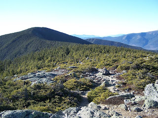
 View to the south over to the Carters and the Sling Shot Slide (top).  View to north of Moriah Shelburne
Route for the day, click here for details

Moriah and Cannon (#30 & #31)

Date of Hike: 1/1/10

Mount Moriah
Carter-Moriah Trail: 9.0 miles (3,550 elevation gain)

Cannon Mountain
Kinsman Ridge Trail: 4.4 (2,200 elevation gain)

Total Miles: 13.4 (5,750 elevation gain)
Click here for trail descriptions

Trip Report:
- With unseasonably warm temps and an imprecise weather forecast predicted I decided to head up Mount Moriah hoping to maybe luck out and steal some views along the way, unfortunately it ended up one of those hikes where the higher you get the more socked in it becomes.
- The drive up from RI went pretty fast, I left at 4am and pretty much cruised controlled through all of NH making a pit stop at Dunkin D's in Gorham, where I ran into Steven (hope I remembered your name correctly!) who recognized me from my blog, nice meeting you!
- On trail 7:45am, summit 10:05am, finished 11:30am. Temps in high 30's to low 40's winds under 15mph, no views above 3,500 feet.
- The White Mountains got hammered with snow just after Christmas but luckily enough the Carter-Moriah trail had been broken out extremely well which was great news because after the first 2.5 miles the trail can become very hard to follow in unbroken snowy conditions.
- I made good time up to Mount Surprise and took in some minor views below to Gorham and into Maine but after that the hike became a slog.
- The warm temps have made the snow heavy, wet, and slippery in spots. luckily I didn't posthole or fall and continued on my way up to the summit, unluckily the last 1.0 miles of this hike dragged and took for what seemed forever.
- Once at the summit I took a picture of the summit ledge rock engulfed in a grey fog turned around and booked it back down the mountain.
- I figured I'd start running into a few hikers on descent but never did. The only highlight was the two big wipeouts I took into the snow!
- Once back at the car I packed my gear and headed south figuring I was done hiking for the day.
- However when I came around the bend on Route 3 into Franconia Notch I noticed the skies were opening up above Cannon and decided to hike up the steep 2.2 miles to the summit. To be safe before I started hiking I gave myself a turnaround time of 3pm.
- On trail at 12:55pm, summit 2:10pm, finished 2:55pm. Very warm temps in the high 40's with very little wind, decent views of Franconia Notch.
- The Kinsman Ridge Trail from the Tramway parking area is steep and pretty unforgiving in the summer. However with the heavy wet snow I figured it be easier with all the rough and rocky footing covered up.
- I was a little bit tired from the Moriah hike so I just tried to keep a good pace and drink lots of water. Luckily to help battle against the steep trail I was able to enjoy pretty awesome views down to Echo Lake and across to Lafayette and Lincoln once in the scrub.
- I thought for sure I'd run into people descending as I hiked up but again I ran into no one!
- Once I got within a half mile of the Observation Tower I was pretty beat up and I could feel my quads weakening. Luckily from here on out it's not as steep and I was able to make my way to the summit observation tower where I took some pics of the cool cloud cover and shot a video (Click here for video).
- The descent was fast and furious! I knew I was going to be able to speed down the trail because of the heavy-wet-padded snow. I took two gnarly slips along the way which were pretty fun and I beat the living crap out of my snowshoes (Tubbs Flex Alps) which after 35 miles of hiking this winter I have never had to adjust them or anything, they are kick ass!

Pictures: Click here for all pictures

Carter-Moriah Trail
 Echo Lake
Franconia Ridge


Wildcat / Carter Traverse

Date of Hike: 9/5/10

Lost Pond Trail: .9 miles
Wildcat Ridge Trail: 5.0 miles
Carter-Moriah Trail: 5.9 miles
North Carter Trail: 1.2 miles
Imp Trail / Bushwhack: 3.0 miles
NH Route 16: 4.0 miles
Total Miles: 20 miles (6,500 elevation gain)

Trip Report:
- This summer I had been hiking all over the Presidential Range and Pemigewasset Wilderness but had yet to venture out to the Wildcat-Carter range so I figured it was time to do a long day hike on the Appalachian Trail.
- On Trail at 8am, finished at 6pm.  Temps in the low 60's below treeline, and high 40's above 4,000 feet with 25 plus MPH wind gusts, with good views.
- The Wildcat Trail always seems to kick my ass pretty good, it is relentlessly steep from Pinkham Notch up to Wildcat "E" Peak. The good news is that there are some pretty fun rock ledges with outstanding views down into Pinkham Notch and even better views across of the Gulf of Slides, Tuckerman, and Huntington Ravine up to Mount Washington and the northern Presidential Range.
- The Wildcat Ski Area lift runs up to the col between "E" and "D" Peak and is a nice place to relax and take in the views before heading along the numerous up and downs across the rest of the Wildcat Ridge. Also the observation deck on Wildcat "D" Peak has been rebuilt so you can take in some great views from there as well.
- From Wildcat "D" across to "A" is a bit of a pain in the butt as you are mostly in the woods traveling up and over "hog-backs" along with rough footing through a narrow trail. Luckily by this time I was able to hike at a good pace and make good time to Wildcat "A" Peak where I enjoyed great views of Carter Notch and the Carter Range.
- The descent to Carter Notch is steep followed by a steep ascent back up to Cater Dome.  While hiking this section all I could hear was the wind above and the loud barks from a dog near the hut below, he barked all the time and was wicked loud, it never shut up, I love dogs but this dogs bark was so bad I skipped out on visiting the hut!
- From Carter Dome I made sure to go up to Mount Height which has some of the best views in the White Mountains.  Views to the east were incredible although views of the Presidential Range were clouded in.  It was very windy and cold on the summit and to stay warm I had to put my hat on while taking a break to relax and refuel.
- The hike over South and Middle Carter was uneventful as usual. South Carter is a wooded summit with no views and Middle Carter has decent views to the east and north.  Both summits have a hand made stick summit sign which are hard to spot but pretty neat.
- The rest of the hike was new to me, I had never been over to North Carter but found it alot of fun, the hiking was pretty fun dropping down to Mount Lethe with good views and a pretty cool section of bog bridges.
- The hike down the North Carter and Imp trails was a drag as I was in the woods and it started to lightly rain.  The highlight was after about two miles on the Imp Trail I bushwhacked over Cowboy Brook southwest to Route 16, it was an easy bushwhack through mostly open and mossy woods.  My original goal was to come out onto the Nineteen-Mile Brook Trail but I didn't go south enough and ended up coming .3 miles north of the trailhead which was good enough.
- Now came the fun part of playing let's not get hike by a car for four miles back to Pinkham Notch Visitor Center.  I tried to hitch a ride for about 15 minutes before it became pointless.  Being labor day weekend the notch was swarming with tourists so I knew they wouldn't stop, so I just enjoyed the walk back to PNVC.
- Back at the car I got my sock full of quarters out and took a nice luke warm shower in the pack room.  The hike over the Wildcat and Carters was a fun hike as  I passed by a few dozen people and a couple of dogs along the way, most of which were having fun.  The hike up to Wildcat "E" Peak is a favorite of mine eventhough it kicked my ass again.  Hopefully someday I'll be able to go back and do the Wildcat-Cater-Moriah Shelburne Traverse and beat feet up to Wildcat "E" Peak!

Pictures: Click here for all pictures

Wildcat Ridge Trail
Looking South to Mount Chocorua
Carter Notch Lake and Wildcat "A" Peak
North and South Baldface

Middle & South Carter, Carter Dome, Wildcat A & D Peak (#18, #19, #20, #21, #22)

Date of Hike: 2/13/10

Nineteen-Mile Brook Trail: 1.9 miles
Carter Dome Trail: 1.9 miles
Carter-Moriah Trail: 6.8 miles
Wildcat Ridge Trail: 2.7 miles
Polecat/Tomcat Ski Trails: 2.5 miles
Total Miles: 15.8 (6,200 elevation gain)

Trip Report:
- Left RI at 3am, on trail at 7am, finished around 3:30
- Temps in the mid teens to high twenty's, wind gusts around 25mph out of the NW above 4,000 feet. Cloudy skies until noon then clear skies with 75 miles plus visibility!
- Made good time up Nineteen-Mile and Carter Dome trails. Carter Dome Trail has a series of seven switchbacks on it which are pretty annoying, two of which are really long and boring!
- At Zeta Pass I switched from microspikes over to snowshoes and booked it over to South Cater, however as soon as I started over to Middle Carter the trail was hard to follow with some snow drifts. Unfortunately the White AT blazes on the trees that you always see when you don't need to see them were few and far between but I stayed on the trail except for one part and was able to get to Middle Carter summit without much of a problem
- Once I got back to South Carter I finally started running into a bunch of people, a dozen over to Carter dome and another eight or so down to Carter Notch
- The hike up to Carter Dome was a struggle at times, the trail was very choppy and narrow and the winds picked up near the summit
- Switched back to microspikes for the hike down to Carter Notch and on the steep parts I glissaded down being careful not to lose control and go into a tree, rock, or over a very long drop!
- Stoped in at Carter Notch Hut to refuel, warm up, and energize myself for the steep climb (1,050 feet in .7 miles) up to Wildcat A Peak
- In the "It really is a small world" outside the hut I bumped into Bill who was the guy who picked me up when I was trying to hitch-hike last month! We then set off for Wildcat and bumped into Jeremy (Rocket 21) who I met on Franconia Ridge in December, and Eric and we all set off to tackle the Wildcat Ridge. Both Jeremy and Eric have done a single season Winter 48 in the past which is a pretty amazing accomplishment!
- The Hike over the Wildcat Peaks was great and the views of the northern presidentials were kick ass!
- Once we got to the Wildcat Ski Area we descended the Polecat trail and enjoyed the close up views of Tucks and Huntington Ravine as skiers and snowboarders zoomed by us
- Back at the Parking lot Jeremy had his truck and let Bill and I get a lift along with him and Eric back to the trailhead which saved us a boring dreadful road walk!

Pictures: Click here for all pictures

Carter-Moriah trail
Carter Dome from Wildcat A Peak
Mount Adams and Madison
Mount Washington from Wildcat Ridge trail
Wildcat Ski Area
Views while hiking down Polecat ski trail
Video: Walking down polecat with skiers going by

Mount Height, Carter Dome, Wildcat A - D

Date of Hike: 11/22/09

Nineteen-Mile Brook Trail: 1.9 miles
Carter Dome Trail: 1.9 miles
Carter-Moriah Trail: 2.6 miles
Nineteen-Mile Brook Trail: .4 miles
Wildcat Ridge Trail: 2.8 miles
Polecat Ski Trail: 2.6 miles
Route 16: 2.5 miles
Total Miles: 14.7 (elevation gain, around 5,000)

Trip Report:
- On trail at 7:45, finished at 3pm. Weather was in low 30's to low 40's, no wind, sunny, no clouds, fantastic 75+ miles views
- All trails in good shape, very little ice on ridges, no blow-downs anywhere
- Carter-Moriah trail to Mount Height becomes very steep
- Views on Mount Height are phenomenal!  You have a clear view of the northern Presidential range including up close views of Tuckerman and Huntington Ravine as well as the Great Gulf, and Madison Gulf, as well as terrific views to the north and east into Maine
- Big group of teenagers at Carter Notch Hut, they had good equipment and must have been part of a hiking club
- The buildings at Carter Notch seem to be newer, lots of improvements seem to have been made over the past few years
- Climb up to Wildcat A was excruciating, elevation gain over 1,000 feet in just .7 miles, the first .4 is up-up-up then comes very annoying switchbacks the last .3 miles
- Met a "hippie type" person on summit of A Peak, he was there with his dog, he and the dog smelled like weed!
- Caught second wind on the ridge over B, C, and A peak
- Killer views from the ski station of Washington, Adams, and Madison
- There was a trail runner there with a can of bear mace, kind of overkill
- Spent a good half-hour at summit stuffing my face with PB&J sandwiches and M&M's!
- Walk down Polecat ski trail was great, had the ravines of Washington in front of me the whole way!
- Walk back on route 16 was tiring, thought about hitching but I gutted it out, fat tourists driving by gave me the weirdest looks!
- Hiked at a quick pace, I did 5,000 feet elevation gain in 5 hours...I slept 11 hours when i got back to RI!

Pictures: Click here for all pictures

Carter Dome from Mount Height

Mount Washington from Mount Height

Carters from Carter Dome

Carter Notch Hut and Wildcat A Peak

View from Wildcat Ski Station

Madison Gulf, Mount Adams & Madison from Polecat Ski Trail

"Trips White" Mount Waumbek, Moriah, and Carrigain in One Day for Completion of the NH White Mountains 48 - 4000's

Date of Hike: 9/6/09

Mount Waumbek
Starr King Trail: 7.2 miles (2,500 elevation gain)
Mount Moriah
Cater Moriah Trail: 9.0 miles (3,400 elevation gain)
Mount Carrigain
Signal Ridge Trail: 10 miles (3,250 elevation gain)
Total Miles: 26.2 (9,150 elevation gain)

Trip Report:
- Solo hike, clear skies, no wind, 75+ mile visibility, temps 45-65 degrees, all trails in great shape
- AT through-hikers on Moriah summit going north to south
- Met a couple on Cater Moriah Trail who were geocaching (People use a GPS to hide and seek containers and find burried treasures) this couple told me they just found some money
- Traffic for Mount Washington Auto Road backed up on Route 16, you could see the sun reflecting off the cars that were at a stand still all the way up to the summit
- Great views from observation tower on Mount Carrigain summit, pretty sure I could see at least 42 of the 48-4000 footers
- First mile down from Carrigain summit was excruciating, ran out of adrenaline and worn down, then caught a 2nd or in this case probably an 8th wind and descended at a good pace
- I've learned this summer on hikes over 20+ miles that stepping in the soft/packed mud that sinks only about a 1/2 inch to an inch is easy on your feet and quite delightful!
- This hike marks the completion of the 48 - 4000 foot mountains of NH

Splits/Temps/Milage:
- Starr King Trailhead 6:10am (211.5 miles) on trail 6:20/summited 7:25/finished 8:50 (temps 45-50)
- Carter Moriah Trailhead 9:10am (18.5 miles) on trail 9:20/summited 11:20/finished 1:00 pm (temps 55-60)
- Signal Ridge Trailhead 2:00pm (34.5 miles) on trail 2:10/summited 4:30/finished 6:50 (temps 50-65)
- 211.5 miles to Mount Waumbek, 53 miles between Waumbek-Moriah-Carrigain, 218 miles home, 482.5 total miles driven
- Left RI at 3am back home at midnight

Pictures: Click here to view all pictures

 View from from summit of Mount Starr KingNorthern Presidential Range
 Looking north from Mount Carrigain Summit to Crawford Notch and the Presidential Range Pemigewasset Wilderness Signal Ridge

Middle Carter (4,610 feet)

Middle Carter from the Carter-Moriah Trail north of South Carter

Middle Cater is located on the Appalachian Trail and has limited views to the east and north from it's mostly wooded summit.  The hike to and from the summit is probably only interesting to peak-baggers looking to knock off one of the 48 - 4,000 footers.  There are a couple of good views of the Presidential Range and surroundings areas between South and Middle and North and Middle Carter.  The two ways to reach the summit of Middle Cater are both off NH16 from the Nineteen-Mile Brook Trailhead via Nineteen-Mile Brook, Cater Dome, and Carter-Moriah Trails, or the Imp Trailhead, via The Imp, North Carter, and Carter-Moriah Trails.

Trip Reports:

August 13th, 2016: MMD 50K 2016

April 17th, 2016: Up NH 16, Camp Dodge Cutoff, Imp Trail, North Carter Trail, across Carter-Moriah Trail and Wildcat Ridge Trail, down Polecat Ski Trail

January 31st, 2016: Up Nineteen-Mile Brook Trail, Carter Dome Trail, across Carter-Moriah Trail, down North Carter Trail, Imp Trail, and Camp Dodge Cutoff

October 4th, 2015: Up Stony Brook Trail, across Carter-Moriah Trail, down Carter Dome and Nineteen-Mile Brook Trail, NH 16 road walk

August 15th, 2015: Up Nineteen-Mile and Carter Dome trails, across Carter-Moriah Trail, down North Carter, Imp, Camp Dodge-Cutoff, and NH16

March 28th, 2015: Up Nineteen-Mile Brook Trail, across Carter-Moriah Trail, down North Carter, Imp, and Camp Dodge Cutoff

January 17th, 2015: Up Nineteen-Mile Brook Trail, across and down Carter-Moriah Trail, up and across Wildcat Ridge Trail, down polecat ski trail, road walk on Route 16

December 22nd, 2014: Up Polecat Ski Trail, across and down Wildcat Ridge Trail, up and across Carter-Moriah Trail, down Imp Trail, Camp Dodge Cutoff, and Route 16

November 10th, 2013: Up and down Nineteen-Mile Brook Trail, Carter Dome Trail, Carter Moriah Trail

June 22nd, 2013: Wildcat/Carter Traverse

May 5th, 2012: Wildcat/Carter Traverse

July 30th, 2011: MMD - More and More Difficult: "Pinkham Notch Loop" Dolly Copp Road, Route 16, Up North Branch of Imp Trail, across Carter-Moriah and Wildcat Ridge, down Polecat Ski Trail, up-over-down Lila's Ledge to Old Jackson Road, Up Tuckerman Ravine and Lion Head to Washington, across Clay, Jefferson, Adams, and Madison via Gulfside, Clay Loop, Jefferson Loop, Isreal Ridge/Lowe's Path, and Osgood Trail, down Daniel Webster-Scout Trail, road walk back to Barnes Field

May 29th, 2011: Moriah/Carter/Wildcat Traverse Traverse

September 5th, 2010: Wildcat/Carter Traverse

February 13th, 2010: Up Nineteen-Mile Brook, Carter Dome Trail, Carter-Moriah Trail (South & Middle Carter), on to Carter Dome, down to Carter Notch, up and across Wildcat Ridge Trail, down Polecat Ski Trail

July 17th, 2009: Up and down Nineteen-Mile Brook, Carter Dome Trail, and Carter-Moriah Trail

Carter Dome (4,832 feet)

Cater Dome and Carter Notch from Wildcat "A" Peak

Carter Dome is the southern most mountain in the Carter Range sitting high above Carter Notch and across from Wildcat 'A' Peak. The summit has obscure views at best, there used to be an old fire tower that was taken down several years ago taking away the magnificent views.  To reach the summit from the west via  Pinkham Notch (Route 16) is by the Nineteenth-Mile Brook Trail and then a steep climb up the Carter-Moriah Trail or hiking the Nineteenth-Mile Brook Trail and Carter Dome Trail. From the East (Wild River Wilderness) the Black Angel Trail and the Rainbow Trail are remote, beautiful, and provide easy grades although longer mileage wise.

Trails I've Hiked

-Nineteeth-Mile Brook Trail and Carter-Moriah Trail: 5.0 miles 3,500 feet elevation gain.  The Nineteenth-Mile Brook Trail has easy to moderate grades and good footing most of the way and is a very popular trail as it ends at the Carter Notch Hut.  The Carter-Moriah Trail asecends north 1.2 miles and 1,550 feet from the Nineteenth-Mile Brook Trail, the trail is very steep at first then ascends moderately and has rough and rugged footing but there are great views down into Carter Notch and across to Wildcat 'A' Peak from outlooks.

-Carter Dome Trail: 5.0 miles, 3,400 feet elevation gain (via Nineteenth-Mile Brook Trail). The Carter Dome trail has easy to moderate grades with good footing, there are a series of several short switchbacks!

Trip Reports:

August 13th, 2016: MMD 50K 2016

April 17th, 2016: Up NH 16, Camp Dodge Cutoff, Imp Trail, North Carter Trail, across Carter-Moriah Trail and Wildcat Ridge Trail, down Polecat Ski Trail

January 31st, 2016: Up Nineteen-Mile Brook Trail, Carter Dome Trail, across Carter-Moriah Trail, down North Carter Trail, Imp Trail, and Camp Dodge Cutoff

March 28th, 2015: Up Nineteen-Mile Brook Trail, across Carter-Moriah Trail, down North Carter, Imp, and Camp Dodge Cutoff

January 17th, 2015: Up Nineteen-Mile Brook Trail, across and down Carter-Moriah Trail, up and across Wildcat Ridge Trail, down polecat ski trail, road walk on Route 16

December 22nd, 2014: Up Polecat Ski Trail, across and down Wildcat Ridge Trail, up and across Carter-Moriah Trail, down Imp Trail, Camp Dodge Cutoff, and Route 16

October 12th, 2014: Up Mount Meader Trail, down Basin Rim Trail, up Black Angel and Carter-Moriah Trail, Down Rainbow and Wild River Trail, up Eagle Link Trail, across Meader Ridge Trail and down Moutn Meader Trail

June 22nd, 2013: Wildcat/Carter Traverse

May 5th, 2012: Wildcat/Carter Traverse

July 30th, 2011: MMD - More and More Difficult: "Pinkham Notch Loop" Dolly Copp Road, Route 16, Up North Branch of Imp Trail, across Carter-Moriah and Wildcat Ridge, down Polecat Ski Trail, up-over-down Lila's Ledge to Old Jackson Road, Up Tuckerman Ravine and Lion Head to Washington, across Clay, Jefferson, Adams, and Madison via Gulfside, Clay Loop, Jefferson Loop, Isreal Ridge/Lowe's Path, and Osgood Trail, down Daniel Webster-Scout Trail, road walk back to Barnes Field

May 29th, 2011: Moriah/Carter/Wildcat Traverse

September 5th, 2010: Wildcat/Carter Traverse

February 13th, 2010: Up Nineteen-Mile Brook, Carter Dome Trail, Carter-Moriah Trail (South & Middle Carter), on to Carter Dome, down to Carter Notch, up and across Wildcat Ridge Trail, down Polecat Ski Trail

November 22nd, 2009: Up Nineteen-Mile Brook, Carter Dome Trail, Carter-Moriah Trail, up and across Wildcat Ridge Trail, down Polecat Ski Trail

August 16th, 2008: Lost Pond Trail, up-across-down Wildcat Ridge Trail, Up Carter-Moriah Trail, down Carter Dome and Nineteen-Mile Brook Trail

Mount Moriah (4,049 feet)

Mount Moriah Summit from the A.T. near North Carter Summit

Mount Moriah is the northern most 4,000 footer that the Appalachian Trail goes over before heading into Maine.  The summit is tiny but is open and offers excellent 360 degree fantastic views of the Presidential Range and the Mahoosuc Notch in Maine.  The most direct route to the summit is hiking up the Carter-Moriah Trail.  Longer approaches can be taken from the Stony Brook Trail or the Rattle River Trail.

Trails I've Hiked

Carter-Moriah Trail: 4.5 miles, elevation gain of 3,400 feet.  The Carter-Moriah trailhead is at the end of Bangor Street off of Route 2 just past the center of Gorham.  The trail has mostly moderate grades with decent footing with a few steep ledge sections.  While most of the hike is in the woods there are decent views of the Presidential Range from the ledge sections around the minor summit of Mount Surprise.

Stony Brook and Carter-Moriah Trail: 4.75 miles, elevation gain of 3,250 feet.  The Stony Brook Trail is located on NH 16 a couple of miles before reaching the center of Gorham.  The trail has great footing and easy grades over the first two miles.  The footing becomes a little rougher and steeper as it gains the ridge but it's still relatively tame compared to White Mountain standards.  Once gaining the ridge the summit can be reached by heading left (north) on the Carter-Moriah Trail for just over a mile.  There are some nice open ledges with terrific views on the way up to the summit.  In my opinion it's a much nicer approach than heading up the Carter-Moriah Trail from Bangor Street.

Trip Reports:

January 17th, 2017: Up and down Carter-Moriah Trail, down Stony Brook Trail, road walk NH16 and RR tracks

August 7th, 2016: Across Highwater Trail, up Moriah Brook & Carter-Moriah Trail, down Kenduskiag Trail & Shelburne Moriah Trails

August 2nd, 2016: Up and down Stony Brook and Carter-Moriah Trail (RUN NH 48 REDUX)

July 5th, 2016: Up and down Stony Brook and Carter-Moriah Trail

June 1st, 2016: Up and down Stony Brook and Carter-Moriah Trail (RUN NH 48) No Report

March 15th, 2016: Up and down Stony Brook and Carter-Moriah Trail

February 15th, 2016: Up and down Stony Brook and Carter-Moriah Trail

December 30th, 2015: Up and down Stony Brook and Carter-Moriah Trail

November 17th, 2015: Up and down Stony Brook and Carter-Moriah Trail

October 4th, 2015: Up Stony Brook Trail, across Carter-Moriah Trail, down Carter Dome and Nineteen-Mile Brook Trail, NH 16 road walk

August 17th, 2015: Across Wild River and Highwater trails, up Moriah Brook Trail, across Carter-Moriah and Kenduskeag trails, down Shelburne, Highwater, and Wild River trails

December 31st, 2014: Up and down Carter-Moriah Trail

March 8th, 2014: Up and down Stoney Brook and Carter-Moriah Trail

September 6th, 2013: Up and down Carter-Moriah Trail

January 21st, 2012: Up and down Carter-Moriah Trail

May 29th, 2011: Moriah/Carter/Wildcat Traverse

January 1st, 2011: Up and down Carter-Moriah Trail

September 6th, 2009: Up and down Carter-Moriah Trail

South Carter (4,430)

South Carter (left) from Carter Dome

South Carter is a wooded viewless summit located on the Carter-Moriah Trail (AT).  If you continue on to Middle Cater there are some decent views of the Presidential Range from an open ledge that the trail runs through for a short section. The hike to and from the summit is probably only interesting to peak-baggers looking to knock off one of the 48 - 4,000 footers. The two ways to reach the summit of Middle Cater are both off Route 16 from the Nineteen-Mile Brook Trailhead via Nineteen-Mile Brook, Cater Dome, and Carter-Moriah Trails or the Imp Trailhead, via The Imp, North Carter, and Carter-Moriah Trails.

Trails I've Hiked

Nineteen-Mile Brook Trail / Carter Dome Trail / Carter-Moriah Trail: 4.6 miles, elevation gain of 3,000 feet.  Nineteen Mile Brook Trail is well defined, has easy grades and good footing while running along the Nineteen-Mile Brook. The Carter Dome Trail has good footing and moderate grades but has about five long boring switchbacks!  The Carter-Moriah Trail is part of the Appalachian Trail and is well blazed, easy to follow has ok footing with decent grades and a short steep section as you approach South Carter summit.

Trip Reports:

December 17th, 2016: Up and down Nineteen-Mile Brook, Carter Dome, Carter-Moriah trails

August 13th, 2016: MMD 50K 2016

April 17th, 2016: Up NH 16, Camp Dodge Cutoff, Imp Trail, North Carter Trail, across Carter-Moriah Trail and Wildcat Ridge Trail, down Polecat Ski Trail

January 31st, 2016: Up Nineteen-Mile Brook Trail, Carter Dome Trail, across Carter-Moriah Trail, down North Carter Trail, Imp Trail, and Camp Dodge Cutoff

December 20th, 2015: Up and down Nineteen-Mile Brook, Carter Dome, Carter-Moriah trails (RUN NH48)

October 4th, 2015: Up Stony Brook Trail, across Carter-Moriah Trail, down Carter Dome and Nineteen-Mile Brook Trail, NH 16 road walk

August 15th, 2015: Up Nineteen-Mile and Carter Dome trails, across Carter-Moriah Trail, down North Carter, Imp, Camp Dodge-Cutoff, and NH16

March 28th, 2015: Up Nineteen-Mile Brook Trail, across Carter-Moriah Trail, down North Carter, Imp, and Camp Dodge Cutoff

January 17th, 2015: Up Nineteen-Mile Brook Trail, across and down Carter-Moriah Trail, up and across Wildcat Ridge Trail, down polecat ski trail, road walk on Route 16

December 22nd, 2014: Up Polecat Ski Trail, across and down Wildcat Ridge Trail, up and across Carter-Moriah Trail, down Imp Trail, Camp Dodge Cutoff, and Route 16

November 10th, 2013: Up and down Nineteen-Mile Brook Trail, Carter Dome Trail, Carter Moriah Trail

June 22nd, 2013: Wildcat/Carter Traverse

May 5th, 2012: Wildcat/Carter Traverse


February 13th, 2010: Up Nineteen-Mile Brook, Carter Dome Trail, Carter-Moriah Trail (South & Middle Carter), on to Carter Dome, down to Carter Notch, up and across Wildcat Ridge Trail, down Polecat Ski Trail

July 17th, 2009: Up and down Nineteen-Mile Brook, Carter Dome Trail, and Carter-Moriah Trail