- Saturday June 16th called for perfect weather and I was lucky enough to get a car spot from Ultra-Runner Adam Wilcox, who would be 'Racing the Sun' as he attempted to complete the traverse during daylight
(click here for his trail run report).
- I took it easy hiking up the Nineteen-Mile Brook trail as the sun set and the woods went pitch black with my headlamp lighting the way for me up to Carter Notch Hut. I arrived at the hut around 10:45p.m., where I was greeted by the hut master at the door and three A.T. thru-hikers sleeping on the floor. I chatted with one of the thru-hikers for a couple of minutes before laying down on a wooden bench. My mind was racing, my confidence was going up and down, and I thought I was going to have a panic attack when I calmly reminded myself that no matter what happens to enjoy the adventure that was about to begin...
- When the clock (Apple Phone) struck midnight I was off, it was time to see if I had what it takes to hike a sub 24 hour hut to hut traverse!
- The hike to Route 16 was a mixed bag, I was making good time but my feet felt weak and my footing wasn't strong leading to a nasty fall which almost broke my trusty camera and did cut my right arm up a little. Once I was on Route 16 I felt better and made the quick road walk to the Great Gulf Trail and crossed the suspension bridge which had a really eerie feel to it at 1:18a.m.
- Like last year I decided to head up the Osgood Trail again because it is much easier to follow in the middle of the night than the shorter Madison Gulf Trail, plus it goes above treeline and this was a perfect night to be above the trees.
- Hiking solo at such a bizarre hour is pretty wild, there are some trails where I feel extremely comfortable and some like the Great Gulf and Osgood Trail (below treeline) which kind of freak me out. I didn’t see any bears, moose, fisher cats, etc., all I saw was a toad on a rock!
- I broke above treeline just after 2:45a.m. and was greeted by clear skies, millions of stars, and no wind! It was an awesome feeling ascending the Osgood Ridge at night as the town of Gorham lit up the ground to the north, the lights of the Mount Washington Observatory could be seen to the south, and dark outlines of the Northern Presidential peaks were looming in front of me.
- When I reached Osgood Junction it was time to cut across the Parapet Trail, I had to do some cairn searching from time to time and I was relieved the weather was perfect because this trail would have been difficult in low visibility.
- I reached Madison Spring Hut at 3:38a.m., filled the camel pack up with water, put Gatorade powder in my hand held bottle and filled that up, downed some muffins, signed the guest book, and headed south.
- As I climbed up from the Madison / Adams col I would turn around every so often and see a faint glow of orange/red/purple colors creeping up from the shoulder of Mount Madison, it was pretty freaking cool.
- I've done this stretch of hiking dozens of times and when I reached Thunderstorm Junction I started to 'rock hop' to the Edmands Col before heading around to the east of Mount Jefferson. I caught an amazing sunrise along the way followed by a ‘sun show’ from the Moticello Lawn at 5a.m. When I reached the Sphinx Col I snapped a really cool picture before smashing my camera on a rock where the lenses popped out. From here until Zealand Falls hut I used my backup camera.
- I hit a little bit of a wall going around Mount Clay and along the Westside Trail below the summit of Mount Washington, luckily the trails have very good footing through these two sections so it didn't crush me and once I hit the Crawford Path I was rejuvenated and started to rock hop/jog the mile down to Lakes of the Clouds Hut and arrived around 6:25a.m.
- The hut crew was busy preparing breakfast as the overnight hikers were waking up and milling around, some inside, some outside while I signed the guest book, refueled, and filled up with water and Gatorade.
- From here the footing gets much better and I felt great as I made my way around Mount Monroe and continued south towards Mount Eisenhower.
- Hiking in the Southern Presidential Range in the early morning was phenomenal and the views were perfect. In just a few hours hundreds of people would be all over the trails, swarms of people would be hopping on the cog up to the summit of Washington, runners would be racing in the Mount Washington Road Race, but you would have never known that as I had the whole range to myslef and there was not another hiker that I crossed paths with while hiking the whole Presidential Range (minus the people in the hut of course).
- From Mount Pierce to Mizpah Springs Hut I went back into rock hopping mode until reaching the hut at 8:11a.m. There were a ton of people inside and outside the hut about to start their day of hiking, breakfast had just been served and it was a zoo! There was a line for the water so I just signed in and got out of there ASAP before getting pulled into a group that was about to embark on their first above treeline experience. Lucky for me I probably smelled like I stepped 'in it' so I was able to escape down the Mizpah Cutoff Trail to safety.
- On the Mizpah Cutoff and Crawford Path I jogged the whole way and made it to the Highland Center at 9:00a.m. I was making great time, had awesome weather, and knew unless I snapped an ankle or blew a knee I was going to hike a sub 24 hour H2H, I was beat up, but still excited.
- The second portion of the hut to hut traverse is daunting, lots of up and downs, mostly in the woods, and it contains the Garfield Ridge. The good news is the footing for the majority is much better.
- My second least favorite part of this hike is leaving the Highland Center and up and down the A-Z Trail, it's not pretty until the very end and is where my injuries caught up to me last year and also where I 'bonked' approaching the Zealand Trail. This year almost had the same results, the ligaments above my left ankle started to hurt and swell just a little bit so I made sure to not push off or land too hard on my left foot. It wasn't getting worse which was good but I did bonk with about a half mile left before the Zealand Trail junction, however since I had been hydrating and eating constantly and I only needed to sit down for a couple of minutes before continuing on and was able to jog the last 0.25 miles to the Zealand Trail and the ankle while tender did not get any worse.
- Once on the Zealand Trail I quickly made my way to the Twinway and up the short steep burst to Zealand Falls Hut at 11:12a.m. Once again at the hut I refueled, filled up my camel pack, dumped the Gatorade powder into my squirt bottle, put a dollar in the basket for a slice of blueberry pound cake, stretched out the left ankle, and had my feet up to circulate the blood a little bit. More importantly I fixed my main camera before pushing on up the Twinway towards Zeacliff.
- From now until Lafayette Place I would run into well over a hundred hikers, it was around noon and hikers were heading in every direction you could imagine.
- The clouds were coming in as I made my way past the Zealand Spur Path but they were still high up so it did not obscure any of the peaks to the west, the Presidential Range now behind me was in and out of the Clouds.
- Breaking above treeline and heading over North Guyot felt great, I had been in the woods since dropping down from Mount Pierce so it was nice to get some views again and this stretch on the Twinway is one of the best in the White Mountains.
- After a few minutes the Twinway heads back into the woods and makes its way up to the summit of South Twin which was the most crowded I have ever seen it. I snapped a few pics, sat down for a couple of minutes to organize my pack for the hellish descent to the most remote A.M.C. hut, Galehead. I rock hopped down to Galehead Hut and the ankle was holding up better than I thought, it was tender and hurting but was not getting worse so I was very relieved.
- I arrived at Galehead Hut at 2:06 smelling like a thru-hiker, while over a dozen hikers relaxed on the hut benches, the rocks, and grass. I went into the hut and did the usual stocking of the water, Gatorade (my last packet), signed the guest book, put two dollars in the tray for some bake good which I stashed away with the rest of my food for the home stretch.
- Now it was the moment of truth, 6.6 miles on the dreaded Garfield Ridge Trail, it's never fun, there are no views until the final mile up the north ridge of Mount Lafayette which has a few demoralizing false peaks. The Garfield Ridge Trail is a roller coaster of PUD’s (pointless ups and downs), it's survival of the hiking fittest for the H2H! I started off strong jogging to the Gale River Trail junction and was able to hike fast to the Franconia Brook Trail junction but then came the steep relentless ascent up to the summit of Mount Garfield. It was slow going, I was looking forward to the waterfall part of the trail...which ended up being a tiny stream!
- I made it the summit of the Mount Garfield and saw that the cloud cover was becoming sparser and knew that the final part of the Garfield Ridge might be a total suffer-fest.
- I quickly descended past the Garfield Pond and into one col, up, then down, down some more, a little up here and there, I was getting beat up and needed to stop, the worst was yet to come from this trail. I was drained and had no energy when I looked up and there was Adam running towards me, remember he started at first daylight (around 4:30a.m.) and had caught up to me with about 7.5 miles to go! Think about that for a second, I started at midnight and was going pretty quick! Incredible stuff.
- When I saw Adam this motivated me to get my ass up and go 'all in', I was able to jog again and even keep Adam in my sight for about a half mile before he turned on the jets.
- I popped up on the north ridge of Mount Lafayette and the sun was beating down and there was no wind. I was beyond exhausted and just kept drinking water every minute or so, this was it - the Garfield Ridge Trail was giving me one final flurry of punches to try to break me and it almost did when I caught a huge break about 0.4 miles from the summit of Mount Lafayette...A nice steady 10 mph breeze came out of the west and saved me and I pushed on up to the crowded summit of Mount Lafayette snapped a picture looked down at my watch, saw that it was 5p.m., and knew that now I was shooting for a sub 20 hour - H2H.
- I don't classify myself as a trail runner, the most I have ever ran continuously on a hike was two weeks ago (2.5 miles in the ADK's on a flat trail), but I pretty much ran down to the Greenleaf Hut from the summit of Lafayette making it there in twenty minutes and did the usual - signed the guest book at 5:22p.m., refilled on water, I was out of Gatorade powder but I was in the clear with that so I downed the last ten ounces in my bottle, saw they had apples for sale and put a dollar in the basket and started my way down to Lafayette place.
- I was thrilled to be eating fruit, except the apple had a worm in it, so I was quick to stop eating it then resumed my running making it to the Old Bridle Path/Falling Waters Trailhead at 6:05p.m.
- My car was right in front of me, I opened it downed some Life Water and took off, I could have dropped my pack to go lighter but it was going to finish this hike with me on my back no matter what.
- Under I-93 I went and across the small field to the Lonesome Lake trailhead through the Lafayette Place Campground. I thought this was 2.5 miles, it's only 1.6, now I had a real chance of a sub 19 hour H2H, I couldn't run or jog anymore so I just put my head down and hiked what seemed like the longest switchbacks east of the Grand Canyon. I made it to Lonesome Lake at 6:40p.m. and went around Lonesome Lake over the bog bridges, I dug down deep and jogged the last half of it, and went up the stairs below the hut and then the stairs up to the door of the hut and touched the hut at 6:47p.m., 18 hours and 47 minutes after I started at midnight, I signed the guest book and was so out of it that I didn't even see Adam sitting there eating some food, he finished in 13 hours and 53 minutes!
- I relaxed at the hut for about fifteen minutes before heading down with Adam, his wife picked him up, I went over to my car, got some clean clothes, walked back under the highway and into the campground to use the quarter operated showers before heading south.
- For the hike I wore La Sportiva Raptors, light weight north face pants, Under Armour t-shirt, REI long sleeve t-shirt and light gloves in the Presidential Range. In the pack I always filled my camel pack to 2.0 to 2.5 liters of water at each hut, had four baggies of gatorade powder which I would put one in the squirt bottle at Madison, Lakes, Zealand, and Galehead huts, 2 EAS protein shakes (these were key to maintaining my strength). For food I had an assortment of crap, but crap that kept me going! mini muffins, a big cookie, four snickers bars, six granola bars, two PB&J sandwiches, (brownie, blueberry pound cake, cookie thingy from the huts). I also brought my first aid trauma kit, winter wind-breaker, hat, mittens, extra long sleeve-t, and UA shirts which never moved from the bottom of the pack!
Splits/Times
12a.m. Carter Notch Hut / 3 hours 38 minutes to Madison Spring Hut (3:38a.m.) / 2 hours 47 minutes to Lakes of the Clouds Hut (6:25a.m.) / 1 hour 46 minutes to Mizpah Springs Hut (8:11a.m.) / 3 hours to Zealand Falls Hut (11:12a.m.) / 2 hours 54 minutes to Galehead Hut (2:06p.m.) / 3 hours 16 minutes to Greenleaf Hut (5:22p.m.) / 1 hour 25 minutes to Lonesome Lake Hut (6:47p.m) - 18 hours 47 minutes.
Cater Notch Hut
Great Gulf Trail Suspension Bridge
Nightime on the Osgood Ridge
Madison Spring Hut
Crescent Moon above Mount Madison
Sunrise from Edmands Col
Monticello Lawn
Sphinx Col
Mount Monroe
Mount Washington
Solar Shower from the Clay/Gulfside Junction Flats
Lakes of the Clouds 'Shark' going for an early morning swim
Lakes of the Clouds Hut
Mount Monroe and Washington from Mount Franklin Flats
Presidential Range from Mount Pierce
Mizpah Springs Hut
Sacco Lake and Route 302
A-Z Trail
Zealand Pond
Zealand Falls Hut
The Twinway
The Twinway
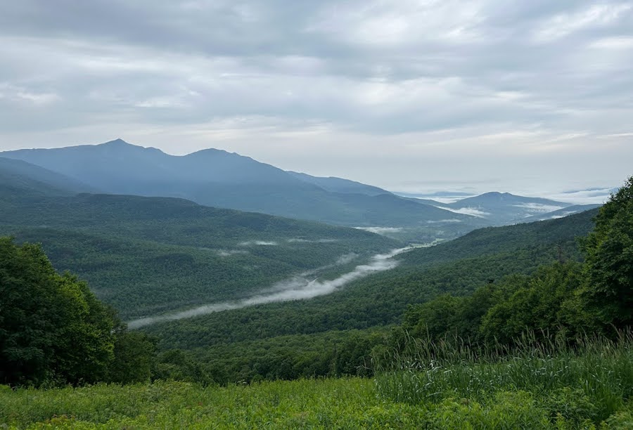
Pemigewasset Wilderness from Guyot area
South Twin Summit
Galehead Hut
Garfield Ridge Trail
The final two stops, Greenleaf Hut and Lonesome Lake Hut (below Kinsman Ridge with Cannon, N. and S. Kinsman)
Greenleaf Hut
Overnighter's about to dig into some apple crisp for dessert at Lonesome Lake Hut
Lonesome Lake Hut