
First up was a Saturday, November 2nd trip to Mount Carrigan. We started at first light before all the weekend warriors came rolling in so we had Sawyer River Road, closed from washouts of the December 2023 storm, and Signal Ridge Trail all to ourselves until halfway back down the mountain. Other than a little rime ice on the summit tower it was smooth sailing, unfortunately Signal Ridge and the summit was in the clouds, so no views were to be had which is a bummer since the summit tower has one of the best views in the White Mountains.

Sarge on an old skidder road which is off trail that cuts off a switchback about halfway up the mountain. Sarge on the summit tower
Sarge and I pushed the pace on Carrigain, finishing the 14-mile 4000' elevation gain in just over three hours so he got Sunday off while I headed to Lincoln to run Owl's Head. Another early start and trails all to myself following the standard route of Lincoln Woods, Black Pond, BP Bushwhack, Lincoln Brook, Brutus Bushwhack and Owl's Head Path. It was cold but comfortable and I was in cruise control enjoying my time alone in the wilderness not seeing a soul until almost back to the Black Pond Bushwhack. All in all it was a terrific morning covering the 16-mile 3250' elevation gain in just over three and a half hours.

Owl's Head as seen from Black Pond Trail
Monday, November 3rd Sarge and I started the week off with a pre-work rock hop up the Rockpile via the Sherburne Ski Trail and Tuckerman Ravine Trail. We started at 6AM and trail conditions were tame and easy with the temperature hovering around thirty degrees with barely any wind. As we passed HoJo's (Hermit Lake) Andrew Drummond caught up to us and we headed up to the summit and back down to the lip together before he speeded off and Sarge and I throttled down enjoying what would be our final Tuckerman Ravine Trail summit of the year!

Sarge heads up the John Sherburne Ski Trail under cotton candy clouds.

Tuckerman Ravine and the now frozen "Falls of a Thousand Streams" lining the headwall

Warm and humid morning in the Willey Range. Sarge waiting patiently in a small clearing just past Mount Avalon and Sarge taking in the views of Crawford Notch from the Mount Willey Outlook
Saturday, November 9th Sarge and I hiked a loop of Mount Passaconaway and Whiteface via Oliverian Brook Trail, Passaconaway Cutoff, Square Ledge Trail, Walden Trail, Dicey's Mill Trail, Rollins Trail, Kate Sleeper Trail, Downes Brook Trail, and X-Country ski trails. A nice 15 mile 4,000' elevation gained route over mostly easy to moderate grades. We got a later than usual start, 9am, to allow for the high winds to die down up high. Unlike the approach from Ferncroft the trails from the Kanc are lightly used and we didn't see anyone until just below the summit of Passaconaway and a few more along Rollins Trail on our way to Whiteface. It was cold but comfortable up high and mild down low as Sarge set a good pace for the day and we completed the loop in three and a half hours.

Sarge standing at the Sandwich Wilderness Boundary on Downes Brook Trail and running in the sun along the cross-country ski trails
Sunday, November 10th we headed to Mount Moosilauke for what was to be a group hike for my friend Ashley's birthday, but everyone dropped out, so it was just the Dood and me. Everyone missed out because it was a stunning morning on Mount Moosilauke. Views from the summit were crystal clear and we could spot the mountains of the Adirondacks in New York. Well worth the long drive from Gorham to have an easy no wind day on the usually windy Moosilauke over bone dry trails!

Sarge on the final approach to Mount Moosilauke's summit

Sarge on South Peak
Wednesday, November 13th, it was back to our usual first light starts as we hiked the Kinsmans from Easton via Mount Kinsman Trail and Kinsman Ridge Trail, 10 miles, 4,000' elevation gained. It was our first hike where we had to tap dance around some ice on both sounds of North Kinsman's summit cone but other than that it was another no traction November morning moving at a good clip along the trails with some decent views from the summits. It was cold above 4K early in the morning but comfortable down low where we ran into a few friendly locals who hike up to Bald Mountain routinely.

Sarge on South Kinsman's throne cairn. From this vantage point it looks like he has a turtle shell, teenage mutant ninja doodle!

Sarge on North Kinsman with Franconia Ridge behind him
Thursday, November 14th I took a PTO day and Sarge and I took the express way up to the Rockpile. Easy conditions as we hiked the swath next to the Cog Railway, no need for traction as we made our way up and down under abundant sunshine and no wind for the win!

The Dood checking out the views of the Northern Presidential Range (Jefferson, Adams, Madison)

Sarge with Mount Jefferson rising high above the Great Gulf
Saturday, November 16th was a day off for the Dood while I headed to Waterville Valley for a favorite loop of mine, Tecumsceolas, over Mount Tecumseh and the Osceola's via Waterville Valley Ski Trails, Mount Tecumseh Trail, Tripoli Road, Mount Osceola Trail, Greeley Ponds Trail, Livermore Trail, and Nordic ski trails. 17 miles and 5,650' elevation gained in just under four and a half hours.
Another early start to the day as I headed up the ski trails to shave off a half mile before ducking back into the woods at an outlook along the Mount Tecumseh Trail. I didn't see another hiker until I spooked someone on the summit, then crossed paths with a few more as I descended the backside of Mount Tecumseh. When I reached Tripoli Road I wasn't feeling great so I throttled down, refueled, and hydrated while keeping an easy pace to Mount Osceola Trailhead and along the first mile of the trail. As I gained elevation, I felt like my normal self again and made good time up over and down the Osceola's to the Greeley Ponds Trail junction.
Along the beautiful and secluded four mile stretch of the Greeley Ponds Trail, I jumped off trail for a mile and headed past an old logging campsite, #5, that was in use from 1915 to the early 1930's where I checked out some old rusted artifacts. This off trail excursion used to be part of the Greeley Ponds Trail before it was washed out just south of the campsite and rerouted up a PUD away from the Mad River

Beautiful morning from the lower slopes of Waterville Valley Ski Area. Mount Tecumseh on the left, Tripyramids on the right
.jpg)
Lower Greeley Ponds

Camp 5 artifacts
Sunday, November 17th Sarge and I headed over Pinkham Notch and down to the Rocky Branch Trailhead for an on and off trail hike of Mount Isolation. We made quick work of the Rocky Branch Trail to the height of land before hopping off trail at the "T" tree where we started the Engine Hill Bushwhack. During the whack we maintained a course along 3250' heading in and out of the many Birch Glades over the next mile. Along the way we saw a huge bull moose who luckily scampered uphill wanting nothing to do with us. After about a mile we dropped down and intersected the Isolation Trail and stayed on this until the Davis Path junction. The Isolation trail was a mix of bare ground, ice, and frozen mud. Unlike the western part of the trail that drops down into the Dry River Valley, the eastern section is not a very attractive or fun trail to travel. Because of this, after summiting we decided to take another bushwhack on the way out.
Isolation Express Bushwhack starts in a small col 0.25 miles from the summit. We were able to follow some tracks in the dusting of snow and once that petered out we were able to stay on course as there was a decent herd path to follow. However, somewhere along the lower half Sarge and I ventured off the normal route to the south and ended up hiking through a semi open plateau before stumbling upon the Rocky Branch where we easily crossed the river and then made our way up a steep embankment where we hooked onto the lower part of the Mount Isolation Trail. We probably saved a third of a mile doing this but saved no time at all. Once back on trail we decided to bypass the Engine Hill Bushwhack and stick to the trails on the way back making for an easy finish to the morning's hike covering the 13 miles and 3600' elevation gained in under four hours.

Sarge posing for a picture as we travel through one of many Birch glades off trail

Windy Mount Isolation Summit with Mount Washington and the Boott Sour in view
Tuesday, November 19th, Sarge and I did a quick hike up to Mount Garfield. Nothing too exciting on trail this day, the summit was windy and in the clouds so we didn't hang around. Trail conditions were pretty good with a dusting of snow starting at 3500' and a fresh couple of inches of snow over the last half mile. We made quick work of Garfield making it up and down before the start of the work day.

Sarge happy to be in the snow at the Mount Garfield / Garfield Ridge Trail junction and enjoying the windy summit of Mount Garfield
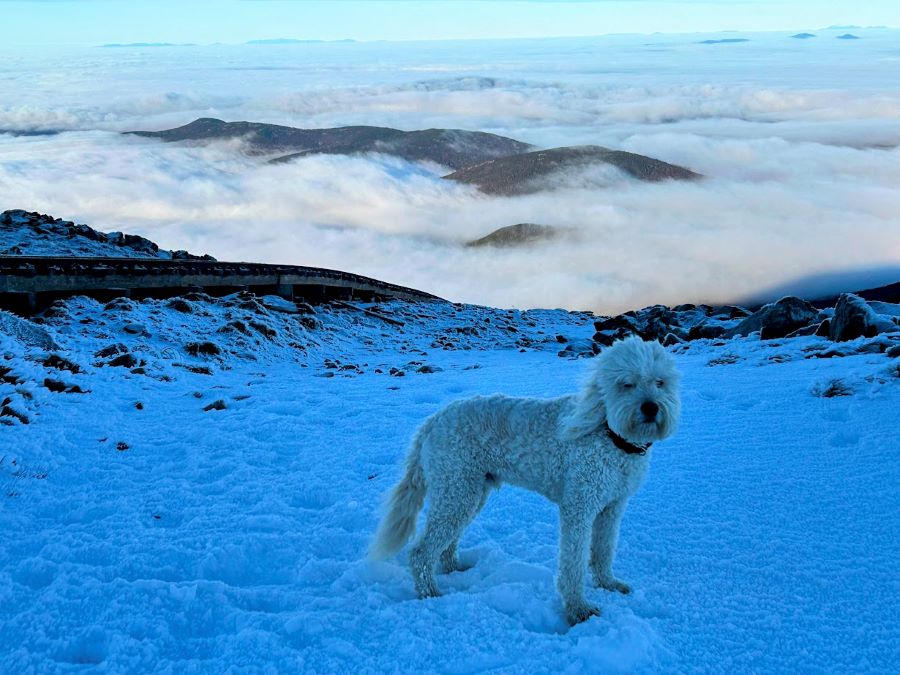
Wednesday, November 20th Sarge and I headed above the clouds for one last no gear hike up the Rockpile until Spring. We had incredible undercast as we headed along the Cog Railway, easy and straightforward hiking while taking in the views and enjoying the mild weather that was already hoovering around freezing. Sage set the pace and we motored up and down in just over two hours. It's been a helluva run on Washington since Memorial Day with Sarge getting up top weekly and we are already looking forward to 5AM June through August starts in t-shirt and shorts in 2025!

Twin Range floating above a sea of clouds

Sarge heads past the warming station where winter Cog riders can get a small taste of the elements

Sarge on trail with undercast blanketing Bretton Woods

Mount Clay and Jefferson

Crossing the tracks along the A.T.

Bright sunshine on the summit of Mount Washington

Sarge on the summit and next to the McAdams & Chadwick memorial cross a few hundred feet from the summit

Sarge basking in the sun on the observation deck

Looking north toward Gorham
One last picture of Sarge and the undercast


