7/6/23
Old Jackson Road: 1.7 miles / Nelson Crag Trail: 3.6 miles / Crawford Path: 1.6 miles / Mount Monroe Loop & Herd Path: 0.6 miles / Crawford Path: 0.4 miles / Old Crawford Path: 1.0 miles / Tuckerman Crossover: 0.3 miles / Tuckerman Ravine Trail: 1.2 miles: Shelburne Ski Trail: 2.3 miles
Total Miles: 12.7 (5,200' elevation gained)
7/7/23
Tuckerman Ravine Trail: 4.2 / Crawford Path: 1.6 miles / Mount Monroe Loop & Herd Path: 0.6 miles / Crawford Path: 0.4 miles / Old Crawford Path: 0.5 miles / Camel Trail: 0.4 miles / Rock Whack: 0.1 miles / Lawn Cut-Off: 0.3 miles / Tuckerman Ravine Trail: 1.2 miles / Shelburne Ski Trail: 2.3 miles
Total Miles: 11.6 (5,050' elevation gained)
7/8/23
Shelburne Ski Trail: 2.3 miles / Tuckerman Ravine Trail: 1.8 miles / Crawford Path: 1.6 miles / Mount Monroe Loop & Herd Path: 0.6 miles / Crawford Path: 0.8 miles / Tuckerman Crossover: 1.0 miles / Tuckerman ravine Trail 1.2 miles / Shelburne Ski Trail: 2.3 miles
Total Miles: 11.6 (5,050' elevation gained)
7/9/23
Tuckerman Ravine Trail: 4.2 miles / Crawford Path: 1.6 miles / Mount Monroe Loop & Herd Path: 0.6 miles / Crawford Path: 0.8 miles / Camel Trail: 0.7 miles / Davis Path: 0.6 miles: Boott Spur Trail: 0.7 miles / Boott Spur Link: 0.6 miles / Tuckerman Ravine Trail: 2.4 miles
Total Miles: 12.5 (5,150' elevation gained)
Trip Report: Thursday, July 6th
- The weather on the Rock Pile finally looked promising enough for a few days of heading up above treeline in the morning and early afternoon before daily thunderstorms came rolling through.
- On day one, Thursday, Todd and I headed across Old Jackson Road to Nelson Crag for a steep hike up to treeline. We started at 10AM and the roots and slab sections were quite greasy below treeline. The weather was disgustingly humid as we sweated our way to the Alpine Zone. Luckily once we broke out of the trees we were greeted with high cloud cover which made above treeline hiking very enjoyable.
Todd maneuvers his way up some slick steep slab below treeline on Nelson Crag Trail
Beautiful above treeline hiking as we passed by Cragway Spring
- Between Agiocochook Crag (5,735') and Ball Crag (6,112') we crossed paths with our friends Gwen and Stacy who were out on their weekly mountain marathon hike. This week's adventure included King Ravine, Great Gulf (Buttress & Wamsutta), Tuckerman & Lion Head, ending with the long descent down the Castellated Ridge. We hiked with them to the summit stopping along the way at the Lizzie Bourne and McAdams and Chadwick memorials located along the Cog Railroad swath.
Gwen and Stacy with Mount Adams and Mount Madison rising up high into the sky behind them
Approaching the auto road and summit cone
Lizzie Bourne and McAdams & Chadwick memorials
Near this spot, Perished January 31st 1932
Earnest Wentworth McAdams, Born 1909
Joseph Benjamin Chadwick, Born 1909
Northern Presidential Range as seen from the observatory
(Clay, Jefferson, Adams, Madison)
- We parted ways with Gwen and Stacy at the summit and headed to Lakes of the Clouds enjoying the views while descending the Crawford Path. At the hut we refilled our water and up Mount Monroe before looping back around the east side of the peak before jumping off trail to follow the original cut of the Crawford Path to try and retrace the steps of two hikers, William Curtis and Allan Ormsbee, who perished while hiking during a snowstorm in June of 1900. Our goal was to find a clump of dwarf spruce where the two hunkered down and the spot where Curtis succumbed to the elements along the old Crawford Path near Lakes of the Clouds. Ormsbee would die higher up the mountain within two hundred feet of the summit, a site which we have visted before where there is a memorial plaque. We struck out trying to find the spruce and Curtis's resting spot but we were determined to study maps and old books that evening and come back on Friday to locate both places.

Descending Crawford Path to Lakes of the Clouds with Mount Monroe in view
Lakes of the Clouds and Mount Washington
Lakes of the Clouds and Mount Washington as seen from Mount Monroe Loop
Southern Presidential Range
Friday, July 7th
- Armed with detailed information, (screenshots from Google Earth and old photos), we headed back up the rockpile at 5AM Friday morning to solve the mystery (to us) of William Curtis's whereabouts. Joining us was our friend Kristina from
White Mountain Endurance Racing.
- We started up the Tuckerman Ravine Trail making quick work up to HoJo's (Hermit Lake) and into The Bowl (Tuckerman Ravine). The last of the snow in the bowl is on life support with only a few patches remaining.
- With all the rain from El Nino over the past month there were plenty of waterfalls flowing everywhere across the headwall.
Kristina and Todd reach Hermit Lake ranger station
HoJo's and Lion Head with Tuckerman Ravine to the left
Heading into Lunch Rocks looking up at the headwall and its "Falls of a Thousand Rivers"
Tuckerman Ravine trail
Todd measures the height of the last of the snow below the falls
Rainbow effect from one of the upper falls.
- Once above the headwall we enjoyed the stellar views as high clouds floated above us against a bright blue sky. Temperature were lovely as we made our way up to the summit and we were thankful to be out of the humidity of the valley below.
Todd and Kristina on Tuckerman Ravine Trail with Boott Spur in the background
Clouds breaking up to the south
Nice mixture of clouds and blue sky early in the morning
Mount Monroe seen behind Todd and Kristina
- We made it to the summit at 7AM to the sound of heavy machinery. The observatory is having two 12,000 gallon water tanks installed so the summit will be quite loud for several weeks. We tapped the summit sign and quickly bolted down Crawford Path to Lakes of the Clouds and Mount Monroe to enjoy more views while traveling the quiet and peaceful trails.
Construction zone
Pretty wild scene up there!
Kristina descends Crawford Path
Todd leads the Way to Lakes of the Clouds
Lakes of the Clouds
Heading up Mount Monroe Loop. What a view!
Kristina heads down Mount Monroe Loop Trail with the Southern Presidential Range in full view
- After summiting Monroe it was time to start our mission. First up was to find the dwarf spruce where Curtis and Ormsbee hunkered down during the storm before trying to continue on. As we curved around the Crawford Path on the eastern side on Monroe we easily spotted the clump of spruce we recognized from
Nicholas Howe's Not Without Peril.
Approaching the clump of dwarf spruce located on the right side of the trail
Kristina hikes past the scrub where Curtis and Ormsbee hunkered down. Notice the small gap in the clump of spruce, that is where they cut branches off and burrowed down.
Todd snaps a picture of me where they huddled up, holding an old tent stake
Todd recreates a photo from Not Without Peril which helped us locate the clump of dwarf spruce
- Next up was to find the final resting place of William Curtis. We knew it was close by on the original cut of the Crawford Path before crossing the Dry River Trail. After a few minutes we were able to find the spot where a memorial plaque used to be. The plaque was stolen by vandals* long ago but the rock that it was bolted into had been chiseled out so it was easy to spot. *A few online ghost stories tell of the plaque being removed and left at Lakes of the Clouds Hut, then returned to the memorial spot, only to be returned to the hut, and finally the hut croo bolting it to the wall of the crew headquarter.
Todd and Kristina at the memorial site for William Curtis
Lakes of the Clouds Hut in view. In 1900 there was no hut so there was no way for the two gentlemen to escape the harsh conditions
The rock where the plaque had been bolted into
Once again Todd Todd recreates a photo which helped us locate the site of the Curtis memorial
- After our mission was complete, we passed by the site of the emergency shelter that was erected after the deaths of Curtis and Ormsbee before jumping onto the Camel Trail. More info on the emergency shelter can be found by
clicking here from a previous trip report.
- Once on the Camel Trail we headed over to Lawn Cut-Off and down Tuckerman Ravine and the Shelburne Ski Trail making it back to Pinkham Notch in time for all of us to drive home (Gorham, Jackson, NoCo) for morning work meetings.
- It was a good start to a Friday and Todd and I were pretty pumped to have been able to retrace the footsteps from this tragic event from 123 years ago.
Kristina and Todd on the old Crawford Path
Site of emergency shelter
Picture of the shelter from Not Without Peril
Hiking along the lightly traveled Camel Trail
Lawn Cut-Off
Descending Tuckerman Ravine Trail
Saturday and Sunday, July 8th & 9th
- Saturday and Sunday Nate joined Todd and I on Washington and Monroe. Saturday was the same route as Friday without the off trail adventure and Sunday we headed out via Boott Spur and Boott Spur Link. Weather on Saturday was already hot and humid when we started at 7:30 so Sunday we were on trail at 5AM and were rewarded with some killer undercast.
- Nothing too exciting to report from either hike except we jumped off trail at the summit of Washington so I could snap a picture of the Allan Ormsbee memorial which I am happy to say is still bolted into a rock.
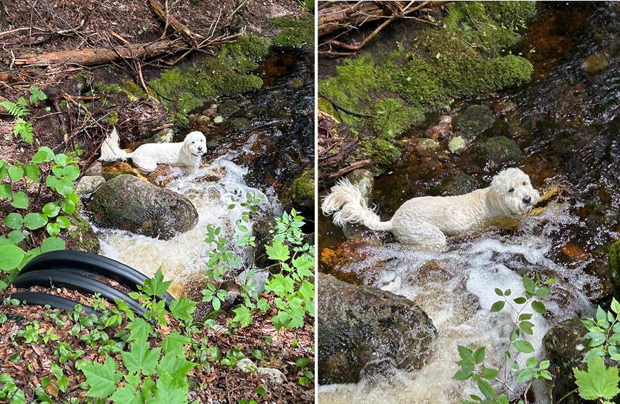
- It was a good four day run of the Rock Pile before the all day rain storms came rolling through Monday and Tuesday. This summer has been never ending subpar conditions so I will be taking advantage of any chance I get to head above treeline like we just had. Hopefully I will be able to get Sarge up for a final Bowl Pawtrol before the last of the snow melts as he was on the DL this week after breaking a claw swimming at Nonna's house :)
Nate and Todd at the Ormsbee memorial. He was so very close to the summit
Memorial
On this spot Allan Ormsbee perished in the great storm of June 30, 1900. Placed by Fresh Air Club of New York
Crystal Cascade furiously flowing after a few inches of rain fell Saturday afternoon and night
5AM start times can be a little rough but once you get above treeline it's easy to get energized with views like this!
Sun rising up and clouds blowing off above Lion Head with undercast blanketing the valley
Clouds blowing across Mount Monroe and Lakes of the Clouds
Undercast fills the notch between the Presidential Range and the Wildcat-Carter-Moriah Range
Pano of Monroe and the Southern Presidential Range
Islands in the sky. 4,000 footers floating above the clouds as far as the eye can see
View from Mount Monroe
Descending Boott Spur
Perfect way to end four days on Washington!
When I got home I took Sarge to Great Glen Trails.
His only objective, find some water. Stay cool Sarge!