Showing posts with label Dry River Trail. Show all posts

Dry River Doodle . . . Webster - Jackson Loop with Sarge

Date of Hike: 7/28/24

Webster Cliff Trail: 6.4 miles / Mount Clinton Trail: 3.0 miles / Dry River Trail: 2.4 miles / Sacco River Trail: 1.6 miles / Webster Cliff Trail: 0.3 miles
Total Miles: 13.7 miles (4,050' Elevation gained)

Trip Report:
- After a double Washington and duel 300th summit of Washington for Todd and I on Friday, it was time to take a break from rock hopping up and down the rockpile and head back to some of the lighter used trails with Sarge. 
- Our route for the morning was to start on the Appalachian Trail at the Route 302 crossing and follow that to Mizpah Spring Hut before dropping down into the Dry River Wilderness along the seldom used Mount Clinton Trail to the Dry River where we'd hook onto the Dry River Trail and then the Sacco River Trail to loop back to the start.
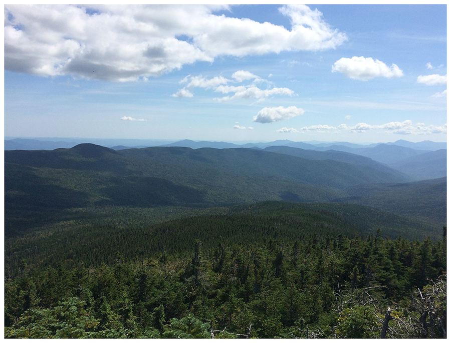
- Webster Cliff Trail (A.T.) wastes no time turning into a rock staircase, it ascends almost 2,000 feet in 1.8 miles to the first open ledge. The gnarly and steep hike up is worth it as one traverses the next 1.5 miles to Mount Webster's summit by passing open ledges with great views of Crawford Notch. 

Sarge, looking thrilled, at the old A.T. sign on 302. I will miss this one when it's replaced.

Webster Cliff Trail, it's a steep staircase in spots

Sarge catching his breath at the first open ledge with Mount Willey in the background

Sarge on along Webster's cliffs

Sarge looking down into Crawford Notch

Taking in the views from Mount Webster's summit

- Next up was the easy hike over Mount Jackson and down to Mizpah Spring Hut. By this time Sarge was muddy and enjoying being up high where it was cooler and not as humid. As we approached the hut we ran into a dozen hikers but from the hut until the end of the hike we would only see one more person, a backpacker who spent the night camping along the Dry River.

One of the few non muddy sections between Webster and Jackson. Sarge already in full mud mode

Dirty Dood on Mount Jackson!

The famous alpine bog just north of Mount Jackson

Sarge sporting some knee high brown boots

Mizpah Spring Hut

- Now it was time for the highlight of the loop, dropping down into the Dry River Wilderness via the Mount Clinton Trail. The trail is a mix of a beautiful soft footing tunnel to a muddy and washed-out semi disaster. Most of the trail descending is easy to follow, only a couple of spots where you have to pay attention closely; one is where there is a huge mud pit, it looks like the trail continues straight but it actually bends to the right up a tiny embankment before straightening out again. The second one is the following water crossing a few minutes later, it's a decent drop down to the brook and the trail on the other side is not easily distinguished as it heads back up the embankment before straightening out again. The third one is always a head scratcher to me, just before the last crossing of Mount Clinton Brook the trail travels along a nice old logging road before veering off down a steep embankment to cross the brook, however the logging road continues straight before petering out, and the turn off the old logging road is barely noticeable, half the time I miss it. The good news is that the drop down to the brook via a short bushwhack is less steep and you're at the water crossing in short order. Finally, is the crossing of the Dry River, the Mount Clinton Trail falls into the river as an old section that parallelled the river has been washed away over the past dozen years. Basically, you have to find the best way of dropping into the river and then walking the river for a few hundred feet before crossing it for good and hooking onto the Dry River Trail. Usually there are a few cairns here and there to help navigate, but do not expect these to be there after any big storm.

Sarge entering the Dry River Wilderness

Nice flowing trail to washed out and rocky

Sarge cooling off at one of the seven brook crossings

Old logging road just before the last brook crossing along the Mount Clinton Trail, and Sarge on a nice flat section of the Dry River Trail later on

Sarge standing where the Mount Clinton trail abruptly falls 10+ feet into the Dry River. We double backed about a hundred feet and found a safe place to drop into the river, or you could parallel the river in the woods heading downstream and drop in where there is not cliff.

Water levels really low so we roam around the river before finally crossing

- Once on the Dry River Trail we made our way past the suspension bridge and to a swimming hole we used to visit near the wilderness boundary, however it is no longer there after the December storm re-arranged the river. We did find an old piece of rail which was a cool find and a nice way to end the day!

Happy to see the suspension bridge still standing after last December's storm

Sarge finds an old rail near a swimming hole that no longer exists

From Friday, Todd and I both summitting Washington for the 300th time!

In and Out of the Dry River Wilderness . . . Mount Pierce & Eisenhower

Date of Hike: 9/5/15

Dry River Trail:  2.9 miles  /  Mount Clinton Trail: 3.0 miles  /  Webster-Cliff Trail: 0.8 miles  /  Crawford Path: 1.2 miles  /  Mount Eisenhower Loop: 0.8 miles  /  Crawford Path: 0.2 miles  /  Mount Eisenhower Trail: 2.7 miles  /  Dry River Trail: 5.2 miles
Total Miles: 17.3 (4,518 feet elevation gained) Garmin 910XT

Trip Report:
- On Saturday morning I met up with my friend Matt (click here for his hiking blog) to do an adventurous hike in the Dry River Wilderness.  The goal for the day was to hike Mount Pierce and Eisenhower by some of the lesser used trails in the White Mountains, the Mount Clinton and Mount Eisenhower trails.
- The Dry River Wilderness sustained major damage in 2011 when Tropical Storm Irene ripped through the northeast, leaving major destruction through the Dry River and the banks along the river.  This was not good for the Dry River Trail as it travels along the river and parts of the trail washed away.  Over the past few years trail crews have tried their best to fix the trail and reroute around the washouts.  Finally, in the fall of 2014 the Dry River and it's trails into and out of the valley were re-opened for business.
- Last October, Whitney and I hiked up the Dry River Trail to Lakes of the Clouds then headed south to Mount Pierce and dropped back down to the floor of the Dry River Wilderness by taking the Mount Clinton Trail.  Little did we know that even though the trail was open it hadn't had seen much trail work over the years and was very overgrown, to this day found I have found it to be the hardest trail in the Whites to follow, we lost it twice, once after a brook crossing were the trail seemed to dead end in a grassy mud pit (the trail was twenty feet away to our right), and then about three quarters of a mile from the bottom of the trail (we kept straight along what we thought was a path on a side hill, when in fact the trail took a sharp right down the hill to the banks and crossed the brook soon after).  Luckily on both occasions we noticed within seconds something was not quite right and we roamed around and found the trail.
-  Since then I had been looking forward to getting back to the trail and hiking up it to see if I could follow it without any issues.  Matt had never been on the trail so he was looking forward to it, too.
- Long story short, we didn't have any issues on the ascent.  The trail crosses the Dry River and hugs the banks for a few minutes to a spot where there is flagging notifying hikers to head into the woods.  The trail is very overgrown in the woods as it parallels a tributary brook for the Dry River, but there is flagging to help lead the way.  The Mount Clinton Trail then heads up to the left of the brook for about a half mile.  The corridor is not too hard to pick out through here, except for a spot where there is a Birch tree blowdown, it's overgrown here and the trail is above the blowdown not below it.  From here the trail was basically more well defined yet narrow in spots.  It crosses the brook several times (almost all have flagging on both ends).  I did notice the spots where we lost trail last year, definitely harder to descend this trail as both spots are tricky not to follow the wrong way.
- The last mile of the trail was in solid shape and dryer with decent footing.  It was fun to get back to the Mount Clinton Trail.  Rumor has it the trail will finally get the TLC it needs within the next year or two.  It'll be fun to see it when it's been cleared and trimmed back but I do hope to get out to it one more time before it's fixed, it's an excellent trail to test your route finding skills
- The rest of the hike was filled with great views above treeline and a nice easy hike back down into the Dry River Wilderness via the Mount Eisenhower Trail.  The Mount Eisenhower Trail is narrow and scratchy over the first half mile but the rest of the trail is in great shape.
- It was a great day for both of us, Matt picked up some red lines (hiking all the trails in the White Mountain Guide).  For me it was another step towards completing the Grid (Hiking all 48 - 4,000 foot peaks in each month).  I have now hiked Mount Pierce and Eisenhower in every month of the year, it took seven years to hike the mountains in every month, and was my 23 time on Eisenhower and 28 time on Pierce.
-  It ended up being a very productive and fun day....AKA the usual!

 The trailhead for the Dry River Trail is just a pullover along Route 302

The trail travels over old railroad grades and passes close by to the Dry River on several occasions

Crossing the Dry River at the start of the Mount Clinton Trail

Looking back down the Dry River Trail (top).  Heading towards the spot where the trail ducks into the woods (bottom)

The Mount Clinton trails treadway is not well defined because it's a lightly used and maintained trail

Matt Crosses one of the lower brook crossings, noticed the flagging

Past one of the smaller crossings is an old chain left behind from the old logging days.

Matt leads the way through another narrow section.  Soon, the trail becomes a little easier to follow

 Another flagged crossing

Headed through some muddy spots.  Somewhere in one of these spots is where Whitney and I lost the trail for a few minutes last fall.  We descended into this and were unaware the trail was just a few feet to our right

 Rock hopping across the brook was very easy with the lack of rain over the past month

Matt maneuvers across the last of seven brook crossings 

As we gain elevation the trail opens up and becomes a much easier and nicer hike

Mizpah Spring Hut

Funny sign in the hut!

From Mizpah Spring Hut we head up Mount Pierce's summit cone and look back south to Mount Jackson

Summit of Mount Pierce

The Presidential Range

Hiking along the Crawford Path to Mount Eisenhower

Looking back to Mount Pierce

Heading up the Mount Eisenhower Loop Trail

Mount Eisenhower Summit

I always like hiking north on the Eisenhower Loop Trail because you get a view of all the intersecting trails and herd paths

Matt heads through the narrow section of the Mount Eisenhower Trail

Looking down into the Dry River Valley

Mount Eisenhower Trail

Matt crosses the Dry River Trail

Heading back out along the old railroad grade of the Dry River Trail

Dry River Bridge

The Dry River

Mount Monroe and Washington

Signs spotted along the way

Route for the day (click here for more details)