
Date of Hike: 7/4/23
Polecat Ski Trail: 2.6 miles / Wildcat Ridge Trail: 2.4 miles / Nineteen-Mile Brook Trail: 2.8 miles / Aqueduct Loop: 1.0 miles / NH16 & Lot C Access Road: 2.0 miles
(10.8 miles, 3,400' elevation gained)
Trip Report:
- With unsettling weather in the forecast on Independence Day I headed to Wildcat Ski Area with the intention of pushing the pace up to the summit of D Peak via the ski trails and heading back down.
- I started out at 7AM and wound my way up the Polecat Ski Trail, which doubles as an UTV access road for ski area workers. The road is in ok shape, crushed rock and dirt with a few eroded spots and a constant steep grade. I was able to trail run at a good clip while enjoying the views of the Presidential Range across the notch.
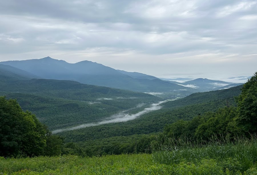
Looking north to Mount Adams and Madison while early morning fog lingers north of the notch hovering over NH16

Looking down the muddy Polecat Ski Trail
- It was a hot and humid morning along the Polecat Ski Trail with a constant threat of rain as clouds quickly started to build as I reached the top of the chairlift and up to the summit outlook platform, making it from bottom to top in 43 minutes and 30 seconds before taking a break to catch my breath. I felt good so I decided to continue on across the ridge through the sloppy wet and muddy conditions from the nonstop month + of rain we have been having here in the White Mountains.
- By the time I reached Wildcat C Peak the Presidential Range across the notch was engulfed in clouds.

Top of the ski slopes with Mount Washington in view

Making my way across the wet and muddy Wildcat Ridge Trail, past some good and not so good bog bridges

By 8AM the clouds overtook Mount Washington and no views were to be had from Wildcat C Peak
- Wildcat Ridge Trail between D & A Peak heads up and down over a series of "Hog Backs" with steep bursts up to C and B summits with a few other PUDs mixed in along the way. It's rocky and rooty with a few obstructed views here and there until reaching the summit of A Peak where there is a grand view of Carter Notch and Carter Dome. Unfortunately, it was almost fogged in while I was there but I was able to snap a decent picture with Carter Dome slightly visible through the fog and clouds.
- There was not much action along the Wildcat Ridge, I ran into a few Appalachian Trail hikers, three NoBo one SoBo, and one day hiker.

Carter Dome through the fog and clouds with Carter Notch barely in view down below
- From the summit of A Peak I steeply dopped 0.7 miles to Nineteen-Mile Brook Trail junction before heading over to Carter Notch. The clouds broke as I reached the notch opening up a nice view up to Wildcat A Peak from Carter Notch Lake.
- It was very quiet at the hut when I arrived. I talked to a trail runner who saw that I was wearing a White Mountain Endurance Racing hat, he had ran the Chocorua Mountain race in the spring of 2022 and was thinking of running Kilkenny Ridge Race this fall. He was at the hut after spending the night with his daughters.
- After filling up with water at the hut I had another conversation with an AMC volunteer/astronomer who was spending a few nights at the hut while sightseeing. He told me about recent research he had done in the new designated International Dark Sky in Maine from a few years ago (details here) all while whittling wood.

Carter Notch Lake and Wildcat A Peak

View from upper Carter Notch Lake looking towards the Ramparts

Carter Notch Hut
- Once I was finished refueling and hydrating, I made my way done the Nineteen-Mile Brook Trail which was mostly a shallow stream from all the rain. It had been a while since I was on this trail with no snow so it was a little shocking to see some of the erosion in places.
- With a mile and a quarter left from the bottom of Nineteen-Mile Brook Trail I jumped off trail at the old dam and hopped onto the Aqueduct Loop, part of the Great Glen Trails, to shave off about two miles of trail and road run.
- At the bottom of the Great Glen trail system I still had a two mile road run on NH 16 back to Wildcat Ski Area, which I made quick work of and got back to my Jeep just as it started to drizzle.
- Today was a good morning on trail and while not the most exciting route around I'm glad I beat the rain and was able to push the pace at times, something I haven't neem able to do much of since I bruised my knee in May. I'm looking forward to upping miles over daily trail runs as the summer continues. Hopefully this awful rainy weather pattern we've had up here will dissipate eventually!

Nineteen-Mile Brook Trail, the upper half is mostly rock with some nice runnable sections mixed in

One sad looking log bridge at the upper water crossing

Nice little cascade at the water crossing. Most summers this is not flowing

This is where I crossed over to the Great Glen Trails system. Nineteen-Mile Brook Trail is on the other side, I crossed over the cement dam on the left. This is one of the best on trail swimming holes around!

Aqueduct Loop is a mix of old woods road and single track

Nice little swimming hole for Great Glen employees to cool off in

Great Glen Trails

NH 16

Signs and interesting points of interest along the way
dailey7779 lives!
ReplyDelete