
Date of Hikes: 9/6 & 9/7
Carter-Moriah Trail: 9.0 miles (3,400 feet)
Eyebrow & Old Speck trail: 7.7 miles (3,000 Feet)
Caps Ridge Trail: 5.0 miles (2,700 feet)
Total Miles: 21.7 (9,100 feet elevation gain)
Trip Report: Moriah
- After leaving Baxter State Park early Friday morning we drove to Saco Maine to a park and ride where the rest of our cars were. I jumped in my Jeep and headed to Gorham and got a hotel room. I arrived earlier than expected so I decided to head and do a quick hike up and run down Mount Moriah.
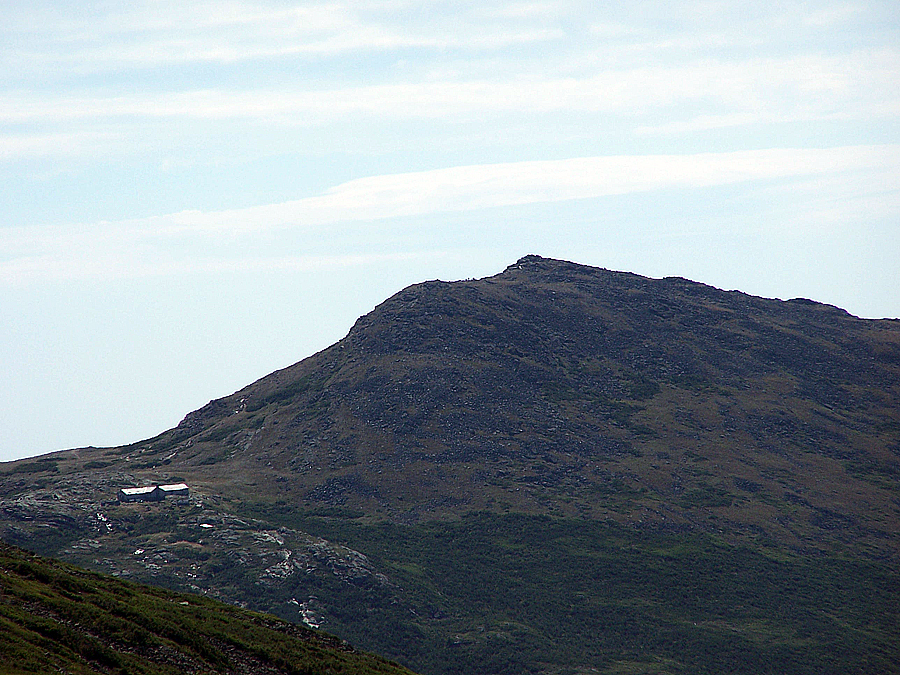
- I saw one person as I headed up, I saw him early on in the hike and then didn't see another hiker. I had the whole mountain to myself. The temps were perfect for a quick hike, high 50's and no wind. There was not a cloud in the sky and the northern Presidential Range was in full view.
- When I got back to the trailhead it ended up being my finish to my fifth round of the 48 - 4,000 footers. First round took 21 years (Washington 88' - Carrigain 09') / second round 20 years (Washington 91' - Carrigain 11') / third round 19 years (Washington 93' - Owl's Head 12') / fourth round 18 years (Washington 94' - Moosilauke 12') / Fifth round also took 18 years (Lafayette 95' - Moriah 13'). I have five or so to go for round #6.
Trip Report: Old Speck & Jefferson
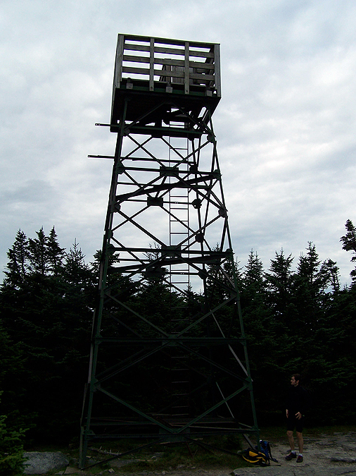
- On Saturday morning I gave a car spot to my friend Tim so he could do a Mahoosuc Range Traverse. After dropping off his car we drove up to Grafton Notch to the Old Speck Trailhead. Grafton Notch is a beautiful place and the hike up to the summit of Old Speck was quick and had some really pretty outlooks along the way. Tim and I hiked up to the summit where there was an old fire tower. There is not much room at the top of the tower, maybe enough for three or four people and the ladder up to it is an old iron rung vertical one. Views from the tower are great!
- From the summit we hiked back to the trail junction where Tim took off for his trail run of the Mahoosuc Range, he ended up doing 32 miles in eleven hour and thirty minutes. Pretty impressive.
- From here I booked it back down to the trailhead and drove over to Jefferson Notch to the Caps Ridge trailhead and started trail running up the Ridge of the Caps so I could catch up with Lee and Dion.
- I finally caught up to them above the third cap at the Cornice / Caps Ridge Trail Junction. From here we hiked up to the summit together, it was pretty windy but temps were in the low 50's so it was perfect for hiking. At the summit we got out of the wind and relaxed and refueled before heading back into the wind.
- The hike down was a lot of fun and by the time we got to the Caps it was warm enough to shed layers again and hike in short sleeves. There were lots of people out on the trail, it's one of the more popular ones on a good weather day since it gets you above treeline relatively quickly.
- It was the first time I descended the Caps in a few years, usually I use the Caps Ridge as a starting point and hike back from the Ammo Trailhead using the Jewell, Boundary Line, and Jefferson Notch Road.
- It was great hiking with Lee and Dion, always enjoy their company and they have a lot of fun on the trails.
- Summer is coming to a quick end in the White Mountains and I was happy to get in a few great weather hikes before it's time to layer up!


Carter-Moriah Trail: 9.0 miles (3,400 feet)
Eyebrow & Old Speck trail: 7.7 miles (3,000 Feet)
Caps Ridge Trail: 5.0 miles (2,700 feet)
Total Miles: 21.7 (9,100 feet elevation gain)
Trip Report: Moriah
- After leaving Baxter State Park early Friday morning we drove to Saco Maine to a park and ride where the rest of our cars were. I jumped in my Jeep and headed to Gorham and got a hotel room. I arrived earlier than expected so I decided to head and do a quick hike up and run down Mount Moriah.
- I saw one person as I headed up, I saw him early on in the hike and then didn't see another hiker. I had the whole mountain to myself. The temps were perfect for a quick hike, high 50's and no wind. There was not a cloud in the sky and the northern Presidential Range was in full view.
- When I got back to the trailhead it ended up being my finish to my fifth round of the 48 - 4,000 footers. First round took 21 years (Washington 88' - Carrigain 09') / second round 20 years (Washington 91' - Carrigain 11') / third round 19 years (Washington 93' - Owl's Head 12') / fourth round 18 years (Washington 94' - Moosilauke 12') / Fifth round also took 18 years (Lafayette 95' - Moriah 13'). I have five or so to go for round #6.
Trip Report: Old Speck & Jefferson
- On Saturday morning I gave a car spot to my friend Tim so he could do a Mahoosuc Range Traverse. After dropping off his car we drove up to Grafton Notch to the Old Speck Trailhead. Grafton Notch is a beautiful place and the hike up to the summit of Old Speck was quick and had some really pretty outlooks along the way. Tim and I hiked up to the summit where there was an old fire tower. There is not much room at the top of the tower, maybe enough for three or four people and the ladder up to it is an old iron rung vertical one. Views from the tower are great!
- From the summit we hiked back to the trail junction where Tim took off for his trail run of the Mahoosuc Range, he ended up doing 32 miles in eleven hour and thirty minutes. Pretty impressive.
- From here I booked it back down to the trailhead and drove over to Jefferson Notch to the Caps Ridge trailhead and started trail running up the Ridge of the Caps so I could catch up with Lee and Dion.
- I finally caught up to them above the third cap at the Cornice / Caps Ridge Trail Junction. From here we hiked up to the summit together, it was pretty windy but temps were in the low 50's so it was perfect for hiking. At the summit we got out of the wind and relaxed and refueled before heading back into the wind.
- The hike down was a lot of fun and by the time we got to the Caps it was warm enough to shed layers again and hike in short sleeves. There were lots of people out on the trail, it's one of the more popular ones on a good weather day since it gets you above treeline relatively quickly.
- It was the first time I descended the Caps in a few years, usually I use the Caps Ridge as a starting point and hike back from the Ammo Trailhead using the Jewell, Boundary Line, and Jefferson Notch Road.
- It was great hiking with Lee and Dion, always enjoy their company and they have a lot of fun on the trails.
- Summer is coming to a quick end in the White Mountains and I was happy to get in a few great weather hikes before it's time to layer up!
Carter-Moriah Trail
Mount Moriah Summit just off to the right
Presidential Range from Mount Surprise
Northern Presidential Range
Carter Range
New bog bridges on the Carter-Moriah Trail
Mahoosuc Range from Mount Surprise
Tim hiking up the cable section of the Eyebrow Trail
Re-bar on the Eyebrow Trail
Re-bar steps along the Eyebrow Trail
In case you weren't sure...the trail goes up and to the right!
Grafton Notch
Old Speck Trailhead
Old Speck
Old Speck Trail
Windmill farm!
Mossy Wall below Old Speck's summit ridge
Views forever into Maine
Old Speck Summit
Looking south to the Presidential Range
Mahoosuc Range
Sunday River
View from the fire tower
Mahoosuc Range
Tim carefully climbing down the tower
Old Speck Fire Tower
AT survey marker
Old Speck Trail
Fall is creeping up on the mountains
Old Speck Trail
Old Speck Trail
Ladder steps along the Old Speck Trail
Mini waterfall just off the trail
Old Speck Trail waterfall
Old Speck trail northern terminus
Old Speck Trailhead
Old Speck Trailhead
Lower Cap on the Caps Ridge Trail
Mount Clay, Washington, and Monroe
Lakes of the clouds Hut and Mount Monroe
Lakes, Monroe, and Lil' Monroe
Looking off towards the Monticello Lawn
Mount Clay and Washington
Brenton Woods, the Twin Range, and Franconia Ridge
Lenticular clouds above the Monticello Lawn
U.F.O. Clouds!
Alpine grass and Mount Washington
Dion heading up to mount Jefferson's Summit
Mount Washington
Lee heading up to Mount Jefferson
Mount Adams
Mount Clay, Washington, and Monroe
The Great Gulf Headwall
Dion trying to get Lee to stand on the highest boulder on top of Mount Jefferson
Lee on Mount Jefferson's summit
Mount Jefferson summit area
Monticello Lawn
Wave of clouds coming in from the southwest
Old marker along the Caps Ridge Trail, this could be part of the survey markers that were put in during the early twentieth century when scouting for a railroad that would have zig zagged across Jefferson and Clay's summit cones on its way up to Mount Washington
Caps Ridge Trail
Castellated Ridge
Lee coming down the Lower Cap
Lee finishing off the Lower Cap
Glacial Pothole Outlook
The Ridge of the Caps!
Glacial Potholes
Dogs on Jefferson!
Ridge of the Caps Black Lab!
Caps Ridge Bog Bridges
Caps Ridge Trailhead
Jefferson Notch
Moose off Base Road
Mamma moose and kid moose off the Base Road
I ENJOYED THE TR AND PICS, BOY YOU'VE BEEN BUSY (YOU HIKED 7 OUT OF 8 DAYS ?), WHEN DO YOU WORK - LOL
ReplyDeleteMARVIN
Thanks Marvin! I had a week of vacation so I spent it up in the mountains!
Delete