
Date of Hike: 1/17/15
Nineteen-Mile Brook Trail: 1.9 miles / Carter Dome Trail: 1.9 miles / Carter-Moriah Trail: 6.0 miles / Wildcat Ridge Trail: 2.8 miles / Ski Trail: 2.3 miles / Access Road & Route 16: 2.8 miles
Total Miles: 17.6 (6,100 feet elevation gained)
Trip Report:
- Whitney was working a double on Saturday, so I decided to do a hike where I could push myself with some decent miles and big elevation gain. The forecast called for temperatures below zero with strong and damaging wind gusts above treeline. Even though I have sufficient gear for that type of adventure I wouldn't enjoy the 'what ifs' that go along with a big solo day in the alpine zone. I eventually decided on heading to Pinkham Notch, staying in the woods, and doing the Carters & Cats.
- I arrived at the Nineteen-Mile Brook Trailhead just before 7:30. The lot was well plowed and only one other car was in it, an SUV, with an Indianapolis Colts flag flying from it, BOO! It was a balmy zero degrees as I put on my microspikes and headed out on the well broken trail.
- The Nineteen-Mile Brook trail sees a tremendous amount of foot traffic since it heads to the Carter Notch Hut which is open year round (Care-taker basis in the winter). The trail has easy to moderate grades so I was able to make good time and stay warm until hooking onto the Carter Dome trail.
- It had been a few years since I was on the Carter Dome Trail, I remember it well as it is one of the few trails in the White Mountains with switchbacks. There are a total of seven of them with # 5 and #7 being the longest. It makes the hike up to Zeta Pass easier as it's never steep, however it has absolutely no views so it's one of those just put your head down and beat feet to the next junction types of trail.
- At Zeta Pass I contemplated switching out to snowshoes but stayed in my microspikes. I felt a little sluggish heading to the summit of South Carter, even though this section has moderate grades the trail had wind swept snow slowing my progress down just a little. When I hit the summit I quickly changed into my snowshoes and felt much better heading over to Middle Carter. I enjoyed this section of trail as the unbroken snow and drifts, along with the sun shining through the woods made for a really picturesque hike down and up to Middle Carter and then back to Zeta Pass.
- At Zeta Pass I finally ran into another hike, none other than Ed Hawkins, who gave me some chocolate. Ed, has hiked the White Mountain 4,000 Footer Grid numerous times and is currently working on another single season winter 4,000 footer list, this time with new knees. It was nice running into Ed, enjoy those new knees and thanks for the chocolate!
- From Zeta Pass I took off to Carter Dome, there were the usual drifting in spots followed by a winter wonderland feel as the trail snaked around snow covered pine trees just before reaching the summit.
- The Carter-Moriah / Carter Dome Trail which coincide for a few tenths of a mile has moderate grades up a 'ramp' like trail corridor from Zeta Pass to the summit of Carter Dome, from the summit down to Cater Notch is totally different story! After a half mile the trail just 'falls down,' it becomes relentlessly steep as it descends to Carter Notch Lake with some fine view points of Wildcat A Peak across the notch. The trail is so steep it's hard to stay on your feet and after a while most say the hell with this and butt slide down a snow luge on and off for a few tenths of a mile before the trail eases up as you reach the lake.
- At Carter Notch Lake I took a short break to fuel up and hydrate before the climb up to Wildcat A Peak which is relentlessly steep as well. It was close to 11:30 so I figured the wind drifted snow up to Wildcat A Peak would be broken out, well it wasn't! The first quarter of a mile until passing the slide was just brutal, drifted snow a few feet deep in spots, this is where I wish I had poles for balance when breaking through snow on such a steep grade. Luckily, once I passed the slide the snow drifts were no more than six to eight inches deep, here I went into steady hike mode as the steep burst up to Wildcat A Peak can be tiring.
- At the summit outlook I took pictures and refueled before heading south on the Wildcat Ridge Trial on what I figured would be a drifted trail. Much to my surprise the trail was already broken back out and in great shape! I was very thankful and made quick time over the 'hogbacks' along the Wildcat Ridge between A,B,C, and D Peaks. I ran into a few other hikers along the way, two were experienced and having fun, two didn't really know what was going on but were enjoying themselves too! Anyway, I made it to the Wildcat D observation tower in pretty good time then hooked onto the PoleCat Ski Trails and booked it down the mountain making sure to stay on the edge of the ski trails as skiers and boarders zoomed on by. The Skiers were all friendly, some said hi on the way by and I saw a family of four navigating an icy patch on the slopes with the dad throwing his daughter over his shoulder and skiing to safety.
- At the bottom of the ski slope I hooked onto the employee access road which dumped me out on Route 16 for an easy twoish mile walk back to the trailhead. Back at the trailhead I instantly froze my fingers up as I fumbled around trying to get my gear into the Jeep and get changed, I hate having constantly cold fingers but it's a price I will gladly pay for hikes on a day like this!
Early morning at the Nineteen-Mile Brook Trailhead
The easy to moderate grades of the Nineteen-Mile Brook and Carter Dome Trails
Carter Dome Trail was packed down and perfect with microspikes
Reaching Zeta Pass and hooking a left onto the Carter-Moriah Trail (A.T.)
Making my way to South Carter's summit
Between South and Middle Carter there were plenty of drifted snow obscuring all previous tracks
Middle Carter in site and the ho-hum side of the trail summit
Heading back to South Carter there are fine views from a small alpine meadow
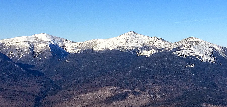
The Northern Presidential Range in full view!
Great view of the Presi's
Mount Washington
Mount Jefferson, Adams, Madison
Up next, Carter Dome. Heading through some minor snow drifts and looking back at my snowshoe track
Heading through a winter wonderland just below the summit of Carter Dome
Carter Dome's summit area. It's partially open from a WWI and WWII era firetower
Next up, Carter Notch!
Wildcat A Peak
Carter Notch Lake
Breaking trail up to Wildcat A Peak
The steep ascent up with a look back to Carter Dome
The sun rising above Wildcat Ridge and shining brightly
The sun is powerful but it's below zero so nothing will melt!
Carter Dome as seen from Wildcat A Peak
Off to hike along the ridge
Mount Washington in full view from Wildcat C Peak
Ravine of the Raymond Cataract
View from Wildcat D observation deck
Skiers having a blast with a view to die for!
Washington - Adams - Madison
Not groomed = fun!
Bottom of the slopes, time to hook onto the access road that will take me to Route 16
Passing the Great Glen Trail system and snow central thingy!
Almost there!
Hiker Ed's SUV and my Jeep, he has a cool plate, I have a goofy one, which I love, UG-3!
Route for the day, click here for details
Nerdy stuff!
You go fast and take amazing photos, plus you never post selfies. Keep up the good work!
ReplyDeleteThanks Brian. It was pretty darn cold out so moving fast kept me warm. As for the pics, years of hiking has given me an idea where to take pics of interesting viewpoints which I hope the reader likes. Currently, I'm using my iPhone so the zoomed in pictures aren't that great but regular point and click shots I've found come out just as good as a digital camera!
ReplyDelete