Showing posts with label Signal Ridge Trail. Show all posts

Happy Dood Year . . . Mount Carrigain

Date of Hike: 1/1/21

Sawyer River Road & Signal Ridge Trail: 14.0 miles / 4,400' elevation gained

Trip Report:

- After a year of compiling miles and elevation gain in the mountains (2,340 / 878,684') I am looking forward to getting back to my normal routine in 2021, hopefully by the summer as the pandemic starts to trend in the right direction. So it's back to trip reports and pics, complete with odd grammar mistakes!
- For the first day of the new year, Sarge and I planned a hike of the Prince of the Wilderness, Mount Carrigain. Joining us were a few of my trail running friends and their dogs for the easy mid-fall conditions hike of Sawyer River Road and Signal Ridge Trail. Conditions were really simple, from a dusting to just enough snow to bury the roots and rocks along the steeps and switchbacks with only a few icy spots that required care.  My studded shoes worked to perfection for the entire fourteen miles.
- We got an early start to avoid the crowds, passing four people and another dog on the way up and having Signal Ridge and the summit tower all to ourselves. Views from the top were surprisingly good as the new snow from the day before made the Presidential Range gleam in vivid white while just a few days before it was a mix of snow and rock and pretty sad looking for winter.
- After spending about ten minutes on the tower taking pictures and relaxing we trail ran back down to Sawyer River Road passing by a dozen or so hikers before reaching the summer trailhead and sprinting the road back to the cars at the winter trailhead off Route 302.
- It was a nice and relatively quiet way to start 2021, hopefully there will be many more days like this!

Sarge on Signal Ridge with the Presidential Range behind him

Sarge on the tower checking out the views

Signal Ridge

Pemigewasset Wilderness, Owl's Head, and Mount Lincoln and Lafayette of the Franconia Ridge

The scarred face of Mount Lowell and the Presidential Range

Looking south over to the Osceola Range

Presidential Range

Snozberry Sarge

Happy Dood Year!

Saturday Morning Stroll Through Spider Webs . . . Mount Carrigain

Date of Hike: 8/22/15

Signal Ridge Trail:  1.7 miles  /  Carrigain Notch Trail:  4.8 miles  /  Desolation Trail: 1.9 miles  /  Signal Ridge Trail: 4.8 miles
Total Miles: 13.25 (4.040 feet elevation gained) Garmin Forerunner 910XT

Trip Report:
- It had been several years since I traveled the section of the Carrigain Notch Trail between the Signal Ridge Trail junction and the Nancy Pond Trail junction.  I remeber it being a beautiful hike and there was one part I was looking forward to getting back to, a short section where the footing on the trail traveled over what could best be described as fish tank pebbles, thousands of thousands of little pebbles for maybe two tenths of a mile on the back side of Mount Carrigain below Carrigain Notch.
- Unfortunately, tropical strom Irene had wiped out that pebble footing I remembered.  It was still a nice hike, the pebble part is now just regular old dirt, but it was not as fun as I remembered it pre-Irene when I hiked it with Chris and Scott's during their 48 - 4,000 footer finish in 2010.
- This approach to Carrigain is very quiet and remote, so if you are looking to avoid the crowds head over and down Carrigain Notch and then hook onto the Desolation Trail. From Desolation you will get a great workout as the trail rises steeply over extremely rough footing for the last three quarters of a mile below the summit.  Also, be prepared to push through dozens of dozens of spider webs between Carrigain Notch and the Desolation Trail junction.  Usually the spiders are tiny in size but every so often you'll come across a big, scary looking one.  Before long you'll be wearing a spider sweater, not fun but it's all part of the wilderness experience!
- Once on top of Mount Carrigain There were hoards of hikers.  I took in the great views from the summit tower and then again along the Signal Ridge.  I don't mind the crowds, I know how to escape them and most of them are extremely nice and happy to be hiking. I counted around three dozen on my way out, everyone was having a great time, and there were even a few friendly dogs out on the trail too.
- As I descended I stayed on the three old sections of trail.  The first one I reached was the top of the reroute around a beaver pond.  What they did was move the Carrigain Notch Trail junction further down the old railroad grade about a quarter of a mile.  The new trail bangs a left and heads around a beaver pond and then hooks into the original trail, I headed through the old trail at this point here and came out at the bottom where the old Carrigain Notch Trail used to split.  This re-route I did once and will probably never do it again, not one of my favorites, so I stick to the old trail.  The next reroute is a short section along Whiteface Brook, it's a little grown in and there's a washout into the brook, the old section avoids a tiny uphill switchback, it's a very short re-route.  The third and final one was the original start of the trail and included a crossing of Whiteface Brook.  It's still easy to follow, the brook became much wider at the crossing after Irene came through so I guess that was the reason for the re-route because the rest of the old trail is in excellent shape.
- All in all it was a fun Saturday morning hike up one of my favorite Mountains.  It also finished my August grid, the first month that I have ever gridded (Grid = hike all the 48 - 4,000 footer in every month).  It only took twenty-seven years, Mount Washington August 31st, 1988 to August 22nd, 2015 Mount Carrigain!
- By year: 1988 (1)  /  1989 (1)  /  2001 (2)  /  2007 (1)  /  2008 (3)  /  2009 (12)  /  2010 (5)  /  2011 (1)  /  2012 (6)  /  2013 (4)  /  2014 (2)  /  2015 (10)

 Hiking along the nice flat Signal Ridge Trail

 Headed up to the height of land on the Carrigain Notch Trail

 Some parts of the Carrigain Notch Trail has a very muddy and wet feeling to it

 Other parts of the trail pass through a beautiful pine grove

 Closing in on the section of trail before the Nancy Pond Trail junction

 Heading to the Desolation Trail junction through another beautiful stretch of woods

The first mile of the Desolation Trail is not too bad.  It's a steady climb but not too steep over descent footing
The second mile of the Desolation Trail is a steep, rocky, and root filled obstacle course!
The Pemigewasset Wilderness from Mount Carrigain's summit
Looking out towards the Franconia Ridge
The Hnacocks (top), Signal Ridge (bottom)
The old fire wardens well
The summit tower and the view up to the tower from Signal Ridge
Carrigain Notch with Vose Spur and Mount Lowell
This is the upper end of the third trail reroute.  The trail goes to the left, the old trail headed right
The old trail is a little washed out in a spot or two but still in great shape.  I prefer it over the re-route
The second Signal Ridge Trail re-route.  This one travels along the brook, there was a washout and it's started to be overtaken by plants.
The first Signal ridge Trail re-route.  It started from Sawyer River Road before the bridge, it travels over the Whiteface Brook.  The new trail starts after the bridge on Sawyer River Road and avoids the water crossing.  The old trail is still easy to follow.
 
Sawyer River Road and Trailhead for Signal Ridge
Signs and an old bottle of Tabasco Sauce!
Route for the day, click here for details

August Grid

Solo Saturday - Mount Carrigain & Mount Jackson

Date of Hike: 12/20/14

Mount Carrigain
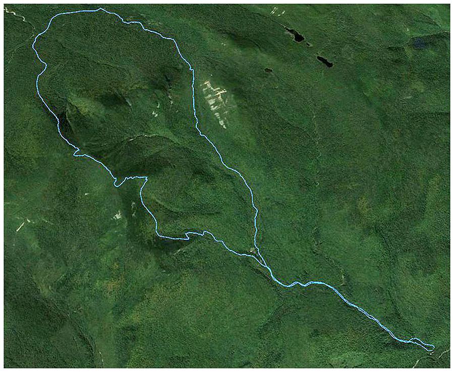
Sawyer River Road:  2.2 miles  /  Signal Ridge Trail: 9.6 miles  /  Sawyer River Road: 2.2 miles
Total Miles: 13.9 (4,440 feet elevation gained) Garmin GPS Forerunner 910XT

Mount Jackson
Webster-Jackson Trail: 5.0 miles (2,300 feet elevation gained)

Trip Report:
- On Saturday, Whitney had to work a double (booo!), but the weather was absolutely perfect (yaaay!), so I drove up Route 302 from North Conway to the Sawyer River Road for a hike up Mount Carrigain to take full advantage of the bluebird day.
- Between the middle of November and April, Sawyer River is closed adding just over two miles to the hike to and from the start of the Signal Ridge Trail.  Out of all the road walks it's my favorite because you get to walk by some of the old foundations that were left over from the town of Livermore. The foundations are just off the road and can be easily spotted in the winter when the leaves from the trees are down.
- There was only one other group heading up Carrigain on Saturday, a group of seven, one of which, Doug, I had hiked with before during my winter Presi Traverse in 2012.  I caught up to Doug's gropu at the beginning of the Signal Ridge Trailhead, took their picture, and continued on my way.
- The first two miles of the Signal Ridge Trail is pretty tame as it travels over old logging roads.  I made good time and I was happy to see the old section of the trail at the Carrigain Notch Trail reroute had seen some use so I took full advantage of that saving close to a half mile of hiking.  I'm not a fan of this reroute, it has a small pud and seems to go too far out of the way.
- After two miles the trail becomes steep as it heads up to Signal Ridge.  The snow depths increased but the trail was still broken out enough that light traction (microspikes) worked fine.  The Signal Ridge Trail takes its sweet time gaining the ridge, unlike most trails in the Whites this one has swithcbacks, so just when you think you're about to hit the ridge, BAM, another switchback!
- Eventually the trail pops out onto Signal Ridge (AKA Burnt Hat Ridge) and the views are incredible.  Right below is a killer view of Carrigain Notch and the slides of Mount Lowell and to the north is a great view of the Presidential Range.
- I put my snowshoes on as the tracks from the day before stopped abruptly and I broke trail the last half mile to the summit tower.  There was about six to twelve inches of snow drifting over the broken trail below.  It was a pretty easy traibreaking and I enjoyed working up a sweat the last half mile.
- On the summit tower I took a bunch of pictures of the Pemigewsset Wildernes; in view was Thoreau and Shoal Pond Valley, Zealand Notch, Whitewall, Hale, Zeacliff, Zealand, Twins, Garfield, Bonds, Owl's Head, and the Franocnia Ridge rising above everything.  I also had a good up close view of the Hancock's and the Osceola's behind them.  To the north I could see the Baldfaces, Wildcats, Carters, and of course most of the Presidnetial Range.
- After taking in the views I headed back down and hiked / jogged my way down the Signal Ridge Trail and then enjoyed the easy walk back to the car along the Sawyer River Road.  I finished the hike around 1:15 p.m. and decided to head up into Crawford Notch and do a quick hike of Mount Jackson and maybe catch sunset from the summit. 
- I ended up making good time up to Mount Jackosn's summit, along the way I saw thirteen other hikers and two happy dogs.  I made it to the summit around threeish so there was no sunset to be had but there was an awesome undercast in Carwford Notch making for some pretty cool views of the Willey Range.  It looked like Mount Willey, Field, and Tom were rising out of a lake with steam coming off the lake, pretty awesome stuff to see.  After taking in the views from the top I bombed it down the mountain and headed back to North Conway to stuff my face full of yummy food.  Not a bad way to spend a solo Saturday!

Sawyer River Road, an old foundation from the town of Livermore, and the Signal Ridge Trailhead 
 Along the Signal Ridge Trail
 Looking up to the summit of Mount Carrigain from Signal Ridge
 Vose Spur
 Heading up to the tower
 Desolation Trail from the tower
 Breaking Trail to the tower
 Bondcliff, Owl's Head, Franconia Ridge and Mount Garfield
 Pemigewasset Wilderness
 Mount Bond
 Zealand Notch with Zeacliff, Hale, and Whitewall
 Mount Lincoln and Lafayette
 Lincoln Slide
 View from the tower looking towards the Presidential Range
 Looking out towards the Hancocks
Signal Ridge
 Signal Ridge, AKA Burnt Hat Ridge
 Osceola's
 Presidential Range
 Webster Cliff through Mount Jefferson
 Presidential Range
 Mount Eisenhower, Monroe, Washington, Clay, Jefferson, Adams
 Mount Monroe and Washington
 Mount Jackson, Pierce, Eisenhower, Clay, Jefferson, Adams
 Baldfaces
 Wildcats and Carters
 Bondcliff Ridge
 Shoal Pond and Throeau Falls Valley
 Whitewall
 Signal Ridge Trail
 The tower
 Signal Ridge
 Mount Lowell Dike
 Webster-Jackson Trail
 Fat Gray Jay!
 Views from Mount Jackson
 Dry River Wilderness
 Southern Presidential Range
 Mount Monroe and Washington
 Monroe and Washington
 Undercast
 Willey rising above the undercast
 Late afternoon int he White Mountains of New Hampshire!
 Willey Range
Descending!
Carrigain Route, click here for details
Route for Jackson, click here for details