
Over the years I have been fortunate to hike some of the more rugged and longer hikes in the northeast. From well known hikes like Presidential and Great Range Traverses, to my own unique routes that I've created while studying the maps. After writing the trip reports and posting pictures I often look at the elevation gains and losses on the graph that is produced from my Garmin Forerunner 910XT. I always like how the elevation profile resembles a roller coaster as it's displayed across the duration of each hike. As of 2015 I live in the White Mountains, and find myself having anywhere from three to five extra hours of time at the end of the weekend from no longer having to drive back to Rhode Island. I've started taking these elevation profiles of some of my favorite hikes while adding graphics and points of interest to them. Below is the final product of several of my favorite 'ultra' one day excursions and one multi-day, hope you enjoy!


24 Four Thousand Footers in 24 hours (peak to peak). Starting from the summit of Mount Flume at midnight, I made my way through the heart of the White Mountains crossing over 24 different 4 thousand foot peaks over the next 62 miles and 23,000 + feet of elevation gained, reaching the summit of Mount Madison at 10:45PM. Total miles trailhead to trailhead 71.5, 26,659' elevation gained in 27 hours. (Trip Report)
My Grid finish (hiking all 48 4000 footers in every month, #66 finisher), and # 1,000 New Hampshire 4,000 footer summitted (60.4 miles, 22,000 feet elevation gained / 65.8 & 23,285 feet overall) Couldn't finish my grid like a sane person so I came up with the ultimate unsupported ultra run/hike. The good news, I avoided the dreaded Garfield Ridge Trail, the bad news, I had to drop down the Lincoln Slide, slog it up and down Owlie slide, then climb back out of the bottom of the Pemi Wilderness during the first half. For the second half I had to drop down into the Dry River Valley and back out on the way to isolation. I don't think I will ever, or want to ever top this one, it was as one friend said my, "Drop the mic moment." :)
(Click here for trip report)
(Click here for trip report)
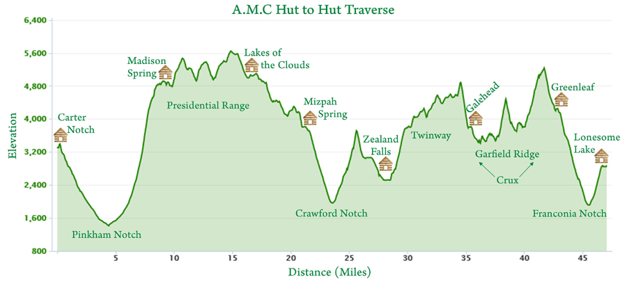
One of my favorites and probably one of the most brutal unsupported 'ultra' hikes in the country. Just under fifty miles and over 16,000 feet of elevation gained while attempting to hike the A.M.C. White Mountain hut system in under twenty four hours. Even though the first half of the hike is over the knee-hammering Presidential Range, the second half is what does in most hikers/runners as the Garfield ridge Trail section can be demoralizing to those not familiar with it. Oh, and the hike in and out form the first hut (Carter Notch) and the last hut (Lonesome Lake) doesn't count as part of the 'timed' route, so add another six miles and 2,000 feet of gain! I've attempted this five times, complementing it four times in 18 hours and 48 minutes, 16 hours and 48 minutes, 15 hours and 14 minutes (Click here for that recent trip report), and my Grid completion adding in Owl's Head and Isolation in 21 hours and 49 minutes, (trip report)
 Is it possible to hike the Presidential Range, get in your car and drive to New York and hike a Great Range Traverse in a single calendar day? The answer is yes! 42 miles, over 18,000 feet of elevation gained, in 22.5 hours including 4.5 miles of driving. (Click here for trip report)
 Same answer to a slightly different question as the Presi vs. Great Range. Only difference was a shorter drive and a brutal second act! The Presidential Range Traverse followed by a Pemi Loop all in a calendar day, 51.5 mile and over 19,000 feet of elevation gained. 20 hours and 3 minutes, including 1 hour 48 minutes of time between hikes (breakfast, driving, gearing up). Click here for trip report
 Putting my own twist on visiting all the huts in one day, from their respective trailheads! Starting at midnight I spent the next 18 hours hiking all the huts and driving around the White Mountains. 50 miles and 18,150' elevation gained with 150 miles driven door to door. Challenging and fun, and very different than anything I have ever done! Click here for trip report
 How do you make a Presidential Range Traverse a little more "isolated" and "wild" ??? You add in the Wildcat Range and a trip to Mount Isolation and loop it all together! 40 miles and 16,000 feet of elevation gained, 13 hours mostly filled with knee hammering rocks, with a small reprieve tossed in while traveling down into and up out of the Dry River Wilderness. (Click here for trip report)
 Nothing like a late night stroll up to Flume for midnight and then hiking until early the next afternoon all the way to Crawford Notch. Who says you can't hike the Franconia Ridge by yourself on a Saturday, well if it's 2AM you sure can! 48.8 miles and 17,210 feet elevation gained. (Click here for report)

43ish miles and over 10,000 feet of elevation gained. This one first came to mind in 2013 and I finally was able to make it happen in 2015. It is one of the more memorable hikes that I've ever done. The drop down into the Pemigewasset Wilderness from the edge of Norcross Pond and the subsequent miles over the old logging roads is rich in history. (Click here for trip report)
 38.6 miles and over 12,000 feet of elevation gained. One of the finest hikes in southern Maine over mostly forgiving terrain and grades, sans A.T. section. The Grafton Notch Loop hike travels over lightly used trails that are very scenic and secluded. The highlight of the hike is the summit of Sunday River Whitecap, located over ten miles from the nearest trailhead and featuring stunning views and all directions. (Click here for trip report)
 I have a soft spot for Mount Isolation. It always seems to get left out while everyone enjoys the peaks in the Presidential Range across the Dry River Valley. This loop made sure to include ISO and the Presi's for a solitude and soft footing hike below the trees to a knee hammering and busy above the trees hike. 34 miles and over 13,000 feet elevation gained. (click here for trip report).

43ish miles and over 10,000 feet of elevation gained. This one first came to mind in 2013 and I finally was able to make it happen in 2015. It is one of the more memorable hikes that I've ever done. The drop down into the Pemigewasset Wilderness from the edge of Norcross Pond and the subsequent miles over the old logging roads is rich in history. (Click here for trip report)
Winter
Trip to Baxter, over four days. Day one and four we pulled our gear
and food in on sled pulks thirteen miles into and out of the park. Day
two we hiked South Turner, breaking trail in a snow storm over four
miles. Day three we got lucky and hiked Hamlin and Baxter peaks on
Mount Katahdin, fourteen miles. A phenomenal winter hiking experience.
I've done tougher and longer hikes but this is the apex of winter hiking in the northeast! (Click here for trip report)
Close to 30 miles and over 10,000 feet of elevation gained. The Maine half of this hike is over very unforgiving terrain, and not just the infamous Mahoosuc Notch portion. The Goose Eye's are worth the aforementioned suffering, an incredible section to hike over. (Click here for trip report)


 AVD : Mount Adams Vertical Day Challenge 2016. Fun day out with other trail runners creating your own path to see how much elevation gain can be accumulated in twelve hours, starting at 6AM and ending at 6PM. 26.3 miles, 14,654 feet elevation gained (Click here for trip report).


Very steep and very rough. Some of the nastiest footing in the northeast can be found between Basin and the Wolfjaws. Around 25 miles with over 9,000 feet of elevation gain. The views throughout the traverse are some of the more dramatic around as steep slides scar the mountains throughout the range. (Click here for trip report)
The classic big traverse in the Whites. Miles and miles of above treeline hiking for hours, wait for a clear day or one with undercast. 24ish miles and close to 10,000 feet of elevation gain. Use the huts to your advantage throughout this hike, but don't linger too long or you might lose your focus on the goal that lies ahead! (Click here for trip report)
31.5 miles and 10,095 feet elevation gained. Spend the day doing one of America's hardest day hikes taking in amazing views from the Bonds, South Twin, Garfield, and the Franconia Ridge along the way! I've been lucky enough to hike this five times and run it twice. When hiking I added on West Bond for even more phenomenal views, 1.0 miles and another 500 feet of gain. (Click here for most recent trip report)
Do you like secluded, lightly used, muddy, and overgrown trails, than this one is right up your alley! The Wild River Loop travels over the lightly used Shelburne, Rainbow, Wild River, and Eagle Link trails along with a eight mile stretch over the Appalachian Trail which is not so lightly used! 29.9 miles, 9,144 feet elevation gained. (Click here for report)
The only hike I've done where my hips were sore the next day. 26 miles and over 9,000 feet of elevation gained. Imagine hiking up and down Wildcat E Peak from Glen Ellis three times in a row, that's what it was like between Indian Head, the Twins, and Plateau. Exhausting but fun! This was before I had my Garmin GPS, so this was taken online from a Devil's Path hike, where I manipulated the graph, added the icons and info to create the hike that I did which was the out and back. I look forward to getting back over to the Devil's Path in the future! (Click here for trip report)
19 miles and just under 8,000 feet of elevation gained. While not as well known as the Presi Traverse just across the notch, it's just as physically demanding as there are more steeper sections mixed in throughout this hike and the terrain is nastier in spots.(Click here for most recent trip report)
25 miles and over 7,000 feet of elevation gained. A real beautiful walk through the woods over several miles with pretty great footing for the most part. Most sections are very quiet and secluded, lots of moose activity. Rogers Ledge has a great view and a perfect last spot to be on before the descent to the end of the hike. (Click here for trip report)
Most of the elevation gain and loss is packed in three short bursts up and down three slides, one of which is an abandoned trail, although still easy to follow for the most part. 20ish miles and about 7,000 feet of elevation gain. (Click here for trip report)
21 miles and over 8,000 feet of gain up and down three of the more steepest ascents and descents in the Presidential Range, one of which is over a trail that was abandoned in the 1960's (Adams Slide Trail). Knee-hammering rocks is the common theme for this tough hike! Created this one myself, pre-GPS. (Click here for trip report)
MMD 50K 2011. 34 miles and around 15,000 feet of elevation gained. This was my first taste of the More and More Difficult ultra trail run, and were my pre-running days so I hiked it. It was a lot of fun, a lot of great views, and very rough on the whole body. After this I kind of got the sense I might be able to hold my own with some of the strongest hikers/runners in the area. Pre-GPS (Click here for trip report)
MMD 50K 2013 & 2017. So you want to run an ultra in the White Mountains of New Hampshire?? Try running down the Madison Gulf headwall and up the Six Husbands Trail and get back to me!! 31.75 miles and almost 15,000 feet of elevation gained. The steep ascents and descents over the nastiest terrain in the White Mountains puts this almost on par with a H2H. Dropping down into and hiking out of the King Ravine twice is extremely difficult but worth it for the scenery! (Click here for trip report)
32.7 miles and over 14,000 feet of elevation gained. Nothing beats spending the morning above and below the Franconia Ridge while spending the afternoon above and below the Kinsman Ridge. The equivalent to being in a pinball machine in Franconia Notch! (Click here for trip report)
31 Miles and just over 10,000 feet elevation gained. Probably one of the more tamer routes for MMD, I tweaked my knee around mile ten and was unable to run for the last twenty miles. A year later I ran this unsupported and injury free! (Click here for trip report)
31 miles and just under 11,000 feet of elevation gained in Evans Notch. This loop travels over two of the most spectacular sub 4,000 foot summits in the White Mountains, the Baldfaces. Part of the route is in New Hampshire and part of it is in Maine, mixing in some popular and less popular trails over generally nice footing with varying degrees of steepness throughout. (Click here for trip report)
MMD 2018, A 50K through the Sandwich Range. One of the more runable routes for MMD with some very fast runners and a very fun time! 31.4 miles, 10,700 feet elevation gained. (Click here for report)
This was part of a Reconnaissance mission for a future hike down the Lincoln Slide. Since I was solo I had to make it back to my Jeep, so I turned it into a big hike in and out of the Pemi. 25ish miles and over 10,000 feet of elevation gain. I took bits and pieces form other hikes over these trails and slide and smooshed them into this, hence the miles not being correct. (Click here for trip report)
26 miles and just shy of 8,000 feet elevation gained over a few lightly used and beautiful trails in the Wild River Wilderness. Rainbow Trail might just have the most beautiful Birch glades in the White Mountains. If you are a grid hiker definitely check out these trails to mix things up on your way up to the Wildcat-Carter Range. Trails used : Mt. Meader, Basin Rim, Black Angel, Carter-Moriah, Rainbow, Wild River, Eagle Link, and Meader Ridge. This hike was done on a perfect autumn day with Whitney, Denise, and Heather & Kali (Click here for trip report)
The Pauper in the Woods to the Prince of the Wilderness, AKA the Pemi Roller Coaster. 45ish miles over mostly old railroad grades through some of the more lightly traveled and beautiful trails throughout the Pemigewasset Wilderness. Ascending the Desolation Trail around mile 40 is a test of physical and mental toughness. September 2016 (Click here for trip report)
South Meadows to Upper Works...maintained trails be damned. This one was an all-day affair with the 'Captain' Tom Diaz. We started just after the sun came up and finished in the dark, hiking over New York's highest point, Mount Marcy, to one of its peaks with phenomenal views, Mount Haystack, before battling the hellish mud monsters of Gray and Cliff peaks! (see said mud monsters below). June 2016 (click here for trip report)
In and above the Zealand and Thoreau Falls (North Fork) Valleys. 38 miles and just over 11,000 feet of elevation gained on a Indian Summer fall day. Highlights of this route include the lightly used Thoreau Falls Trail as it parallels the North Fork, the abandoned Wilderness Trail, and the super huge views from the Bonds. September 2017 (click here for report)
Prince of the Wildeness 50K, AKA Carrigain the long way! The first 23 miles has decent footing and rolling terrain over lightly used trails, perfect for a nice trail run, then comes the absurdly steep ascent up Mount Carrigain from Desolation! 31.6 miles, 6,950 feet elevation gained (Click here for trip report)
When you want to get in the miles but you want to give your feet a break from knee hammering rocks, stay low and on lightly used trails with little erosion and few people. 32 miles and just under 5,000 feet of elevation gained. (click here for trip report)
AVD : Mount Adams Vertical Day Challenge 2017. Fun day out with other trail runners creating your own path to see how much elevation gain can be accumulated in twelve hours, starting at 6AM and ending at 6PM. 30.4 miles and 15,025 feet elevation gained. (Click here for Strava data)
AVD : Mount Adams Vertical Day Challenge 2018. Fun day out with other trail runners creating your own path to see how much elevation gain can be accumulated in twelve hours, starting at 6AM and ending at 6PM. 34.3 miles and 18,873 feet elevation gained (click here for trip report)
2017 Chad Denning Memorial 50K Moosilauke Run. A very fun and scenic route up, down, and around Mount Moosulauke in memory of Chad who was an accomplished and universally liked ultra runner. (September 2017). Click here for run report
My finishing hike to become an Adirondack 46R, becoming the 7,309 person to hike all 46 High Peaks of the Adirondacks. Finished on a beautiful fall day during Columbus Day weekend in 2011. I had Big Slide and Sawteeth left so I decided to see if I could combine them while going over one of my favorite peaks, Gothics. To this day hiking the 46 high peaks in the spring, summer, and fall of 2011 is among one of my favorite adventures. Pre-GPS. (Click here for trip report)
Rocky Peak Ridge between the summit of Rocky Peak Ridge and Bald Peak is a phenomenal hike with great vistas along the way. 16 miles and 6,500 feet elevation gain as an out and back, FYI, with a car spot last year my friend Diaz and I hiked from 73 to 9 (Zander Scott Trailhead to New Russia) 11.5 miles and under 5,000 feet of gain. (Click here for trip report)
I started out at the South Rim and it was 45 degrees, hit 90 plus while heading back through the 'Box' near the bottom of the canyon in the early afternoon. Along with the H2H, this my favorite hike/run I've ever done. 45 miles and over 10,000 feet elevation gain. :) (Click here for trip report)
Rim to Rim to Rim take II & III. In May of 2017, Whitney and I hiked it (same elevation profile as the one above this one), and then a week and a half later I ran one, starting at midnight from South Kaibab and finishing at 11:30AM at South Kaibab. Heading back up South Kaibab was not one of my best ideas as it was brutal! Had a blast and an interesting encounter with dozens of bats throughout the night! (Click here for trip report)
This is awesome and impressive on so many levels! Thanks for posting and the small blurbs for each. Seems like your ADK experience will live with you forever!
ReplyDeleteHi Phillip, glad you liked the profiles and descriptions. The ADK's has a special meaning to me and I always look forward to hiking there or the Catskills the one or two times a year I get out to NY. :)
Deletethis is amazing and definitely sparking some ideas for my next trip up to the northeast
ReplyDeleteThanks, hope you get to try one of them out and you get a good day to do it. One of the best parts for me is stuffing my face full of food after!
DeleteGreat recap of awesome hikes. I didn't know about those ultra races, they look brutal! The slides add interesting twists and huge gain!
ReplyDeleteThanks, Richard. The slides really slow the pace down and can increase a split dramatically during the hikes/runs. This summer I'm hoping to do an ADK "Marshall" loop - Big Slide, Great Range, McIntyre Range that another hiker told me about. I'll let you know if I plan to do it and see if you'd like to join in!!
Delete