
Date of Hike: 9/16/17
Direttissima: 1.0 miles / Glen Boulder Trail: 2.8 miles / Davis Path & Iso Spur: 4.2 miles / Isolation Trail West: 2.4 miles / Dry River Trail: 0.2 miles / Mount Eisenhower Trail: 0.3 miles / Dry River Cutoff: 1.7 miles / Mount Clinton Trail: 0.5 miles / Webster-Cliff Trail: 0.9 miles / Crawford Path: 1.2 miles / Mount Eisenhower Loop: 0.8 miles / Crawford Path & Franklin Herd Path: 1.6 miles / Mount Monroe Loop: 0.7 miles / Crawford Path: 1.6 miles / Gulfside Trail: 1.1 miles / Mount Clay Loop: 1.2 miles / Gulfside Trail: 0.7 miles / Mount Jefferson Loop: 0.7 miles / Gulfside Trail: 1.5 miles / Israel Ridge / Lowe's Path: 0.4 miles / Airline: 0.6 miles / Gulfside Trail: 0.3 miles / Osgood Trail: 3.0 miles / Osgood Cutoff: 0.6 miles / Great Gulf Trail: 0.1 miles / Madison Gulf Trail & Lowe's Bald Spot: 2.3 miles / Old Jackson Road: 1.9 miles
Total Miles: 34.3 (13,107 feet elevation gained) A.M.C. White Mountain Guide Online
Trip Report:
- On Saturday's, I have around twelve hours to get in a hike/run before having to be home for puppy duty. Whitney leaves for work at 3pm and Sgt. Pepper, "Sarge" gets crate training for a few hours, so whatever it is I'm doing I like to be home for 6:30PM at the latest.
- With the weather being unseasonable hot, valley weather above treeline, I looked over the maps in search of a big mile and creative route close to home. I decided to incorporate Isolation with a Presidential Range Traverse looping it all together. Basically it was a day that Isolation, which is known for being a loner, got to hang out with the big boys!
- I started off from Pinkham Notch Visitor Center at 6:40AM, taking the Direttissima a mile to the Glen Boulder Trail. Even though fall was not in the air, the leaves are changing colors fast in the notch making the usually not so attractive hike along the Direttissima and the below treeline section of Glen Boulder Trail a very pretty one.
- The Glen Boulder trail is a real grind over the first two miles, it's steep and the footing is unforgiving, however it is worth it once breaking out above treeline and passing by Glen Boulder and past Slide Peak, with great views in every direction.
- At the top of Glen Boulder Trail I headed south along the Davis Path, dropping back below treeline over to Mount Isolation. The Davis Path is an interesting trail, above treeline it's beautiful, below treeline it's a mixed bag, some spots are in great shape while others spots are quite muddy, especially just north of Mount Isolation, where there are probably the worst bog bridges in the White Mountains, some of which are broken in half and useless.
- Once summiting Mount Isolation, I made my only backtrack of the day heading north to the Isolation Trail West junction, here I dropped down to the Dry River Valley. Isolation Trail West is a lightly used trail with great footing, minus the Tropical Storm Irene washouts near the bottom of the trail.
- After a quick descent, I hooked onto the Dry River Trail for a few tenths of a mile before taking a sharp left onto the Mount Eisenhower Trail which lead me to the Dry River Cutoff . I ascended this trail and the upper section of the Mount Clinton Trail to Mizpah Springs Hut. Just like Isolation Trail West, all these trails are lightly used and a great way to get away from the crowds, which was about to end.
- Up until this point I had seen one hiker, from the hut until Mount Madison's summit, I would see hundreds! Even with the absurd amount of people above treeline, I still enjoyed every step along the range, I never got stuck behind anyone unwilling to move over, or ran into any obnoxious hikers. Moving quickly also meant I could enjoy pockets of trail all to myself, including some of my favorites; the initial drop off of Mount Eisenhower, Presidential Lawn before Mount Franklin (AKA Franklin Flats), Monticello Lawn, and the rise up to Thunderstorm Junction.
- Along the way, the stops at the huts (Mizpah Spring, Lakes of the Clouds, Madison Spring), were filled with spending $2 for some yummy goodies, apple cake, blueberry cake, and lemon poppy cake with frosting! I also stopped at the cafeteria on top of Mount Washington to pick up a Snickers bar and a Powerade. Having these "cheat spots" along the way made it very easy for me to pack light when it came to water and food.
- After traversing the Presidential Range's summits, Pierce-Eisenhower-Franklin-Monroe-Washington-Clay-Jefferson-Adams-Madison, I was back to being alone on the trails for the final seven miles back to Pinkham Notch via Osgood, Madison Gulf, and Old Jackson Road trails, seeing only a group of three at Osgood Junction and couple more hikers below treeline, and no one over the last five miles. I made it back to Pinkham Notch shortly after 5PM and made the short drive home for a nice relaxing night with Sarge.
- It was a tail of two hikes, solitude and sweet footing to knee hammering rocks and coo coo banana tourist hikers, while enjoying ever minute of it! :)
Elevation over distance profile, click here for Strava data
Leaves starting to change colors and blanket the trail along the Diretissima
Hiking up the Glen Boulder Trail
Popping up above treeline and spotting Glen Boulder sticking out along the ridge
Glen Boulder
Views from Glen Boulder and the shoulder of Slide Peak
Looking down to Pinkham Notch, a warm and hazy morning
The Davis Path
About to drop below treeline with the next target, Isolation, a few miles off in the distance
The Davis Path, some sections are nice, others are a complete mess!
Mount Isolation summit
Descending the soft and easy grades of the Isolation Trail West
Crossing the Dry River
Dry River Cutoff, more easy grades and soft footing!
Mizpah Spring Hut and hiking the Webster Cliff Trail up very well placed ladder steps
Last of the clouds clearing off the Presidential Range as seen from Mount Pierce
Hiking the Crawford Path to Mount Eisenhower
Looking back to Mount Pierce
Mount Eisenhower's summit
Red Pond and the intersecting trails as seen from Mount Eisenhower Loop
Hiking north on the Crawford Path while looking south to Mount Eisenhower
Presidential Lawn / Franklin Flats. A beautiful spot along the Crawford Path
Looking down into the Dry River Wilderness from Mount Franklin. This is where I went down into and came out of a few hours earlier
Mount Monroe Loop
Southern Presidential Range
Mount Monroe's summit view
Lakes of the Clouds and Mount Washington
Lakes of the Clouds
Mount Monroe
The Great Gulf Wilderness
Another shot, a little more zoomed-in of the Great Gulf Wilderness
Hiking along the Gulfside Trail towards Mount Clay
Great Gulf Headwall
Hiking along the Mount Clay Loop
Next up, Mount Jefferson
Looking back at Mount Clay and Washington
Monticello Lawn, such a breathtaking spot!
Next up, Mount Adams
Hiking the Gulfside Trail north
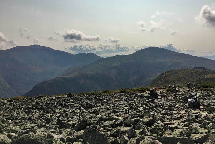
Quintessential theme in the northern Presidential Range, boulder fields!
Thunderstorm Junction
Summit of Mount Adams looking down at sub peak JQ Adams, Star Lake, and Mount Madison
Madison Spring Hut and the summit cone of Madison
The hut, JQ Adams, and Adams
Star Lake and Mount Madison. Clouds starting to slowly build again above the range
Summit of Mount Madison
Osgood Ridge
Hiking the Osgood Trail
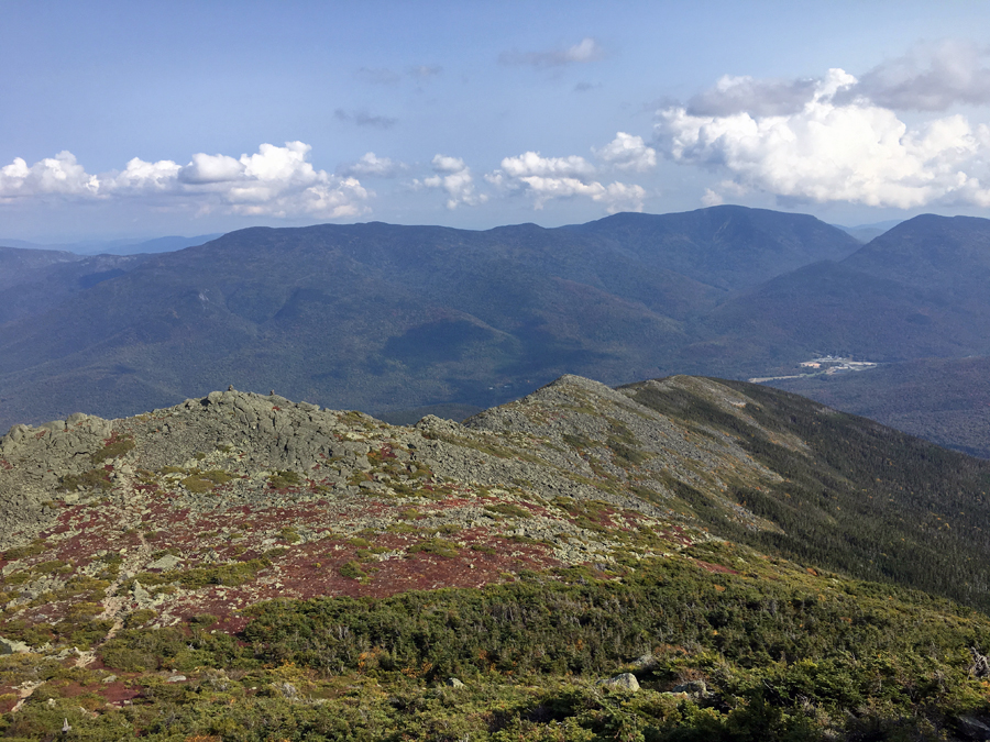
The last section of above treeline on Osgood Ridge, with a nice view of Carter Notch in the distance
Looking back up at Adams and Madison before dipping below the trees for good :)
Back below treeline through the Great Gulf Wilderness to the Auto Road crossing
Pano of Washington, Adams, and Madison, from Low's Bald Spot
A nice last two miles on Old Jackson Road as the leaves fall, great way to end the hike!
Trails signs from Pinkham Notch to Mizpah Spring Hut
Trail signs from Mizpah Spring to Madison Spring Hut
Trail signs from Madison Spring to Pinkham Notch
Sgt. Pepper "Sarge," spent the day gardening (digging for bugs) with mommy, thrilling! Followed by getting cleaned off with the hose and dried off, not so thrilling! :)
No comments:
Post a Comment