Showing posts with label Pierce. Show all posts

Tuckerman Ravine Throwdown / Leaf Peepin' with Sarge / Crawford Notch Loop

Tuckerman Ravine Throwdown & RUN NH48 #47

Tuckerman Ravine Trail: 8.4 miles, 4,250' elevation gained

Fall started off with extended summer weather until the second week of October. My initial plan was to run Mount Lafayette for my RUN NH48 project I have been working on now for ten years. Lafayette would have been peak #47, saving my home mountain, Washington, for #48. However, Andrew Drummond of White Mountain Ski Company & Run the Whites put out a challenge to all trail runners called the Tuckerman Ravine Throwdown. He would give out gift cards to the top ten fastest uphill ascents on Tuckerman Ravine Trail for both men and women between September 19th and October 14th. I wouldn't be able to sniff the top ten, but I thought it would be a blast to incorporate this into my up and down speed run of Washington for #47. 
- I break the Tuckerman Ravine Trail down into two sections, the first is Pinkham Notch to Hermit Lake (Hojo's), 2.4 miles and 1850' elevation gained over moderate grades with a mix of dirt and rocks of all sizes, followed by HoJo's to the summit, 1.8 miles 2400' feet elevation gain with steep grades over a rock staircase and odd sized big boulders.
- My goal for running Mount Washington has always been an under two hours up & down. With perfect conditions I knew I could go under forty minutes on the descent but it was going sub 1:20 on the ascent that would be the make/break point. I set my goal for this ascent at a 1:18, (previous PR was low 1:20's) which should leave me just enough time to break the two-hour mark.
- On Tuesday, September 24th I woke up, packed my running vest, drove ten minutes down the road to Pinkham Notch, and started my run at dawn around 6:30am. It was a nice cool morning, temps were in the mid-forties, perfect for running as I motored up the first 2.4 miles to HoJo's. I passed a couple of early morning hikers in the first half mile then I wouldn't see anyone else on trail until halfway down the mountain. my previous PR to Hojo's was 35:49, last September, this time around I was hoping to knock 90 seconds off, mission accomplished, I huffed and puffed my way to a 33:15 with Hermit Lakes caretaker, Jimmy Rips, popping out of the ranger's cabin and cheering me on. As you can see from the screenshot below, I did not come close to the top ten on this Strava segment but still impressive none the less considering how many people have "ran" Tucks.

Very impressive times, it's mind-boggling to me how fast the top ten covers this first section of Tuckerman Ravine trail

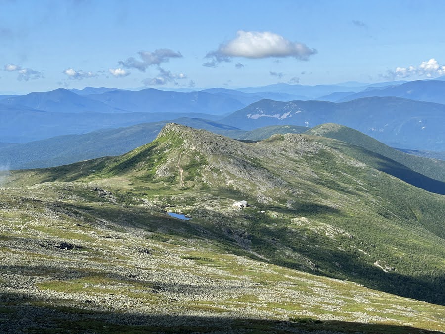
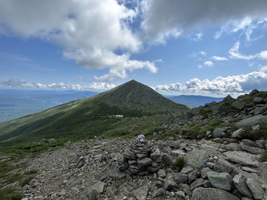
- From HoJo's to the summit is when it gets steep, first up a rock staircase to the first aid cache, 0.6 miles 600', then a short reprieve to Lunch Rocks, followed by another steep rock staircase the parallels the waterfall to the switchback, then the trail steeply rises up to the lip and above it to Tuckerman Junction over rocks of all sizes, some loose and some stable, 0.6 miles 900'. From Tuckerman Junction to the Auto Road it is rock hopping at its finest over boulders of all sizes, 0.4 miles 700', finally it's 0.2 miles and 200' of road/staircase/gravel/summit rock pile.
- I love the second half of Tuckerman Ravie Trail, it's steep and gnarly with breathtaking views. I made good time to the bottom of the waterfall/Lunch Rocks making it to the second rock staircase in about twelve minutes, from there I held on up through the lip to Tuckerman Junction in fourteen minutes, making the turn towards the summit in just under an hour. 
- From Tuckerman Junction to the summit the grade eases ever so slightly, it's still steep but turning over the legs is not as difficult as going through the two staircase sections below the headwall. I covered the last 0.6 miles in about fifteen minutes arriving at the summit in 1:14:52, three minutes ahead of my goal. 

Sub one hour for the elites, let that sink in for a minute, incredible! Not too shabby time for me too!!

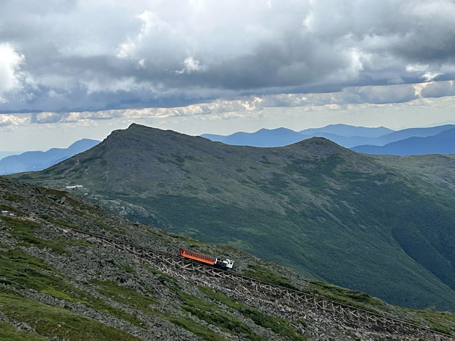
- Sub two was definitely in sight, and as I started rock hopping down I kept picking up the pace, tap dancing through the technical terrain past Tuckerman Junction down the headwall and by Lunch Rocks to HoJo's. The rocks below Hojo's were dry and grippy and I ripped it down. While I can't keep up on the uphill with the elites I'm proud to say I can hang with any of them on the technical descents, trying to navigate quickly downhill over this type of terrain levels the playing field, advantage me! I made it from the summit to the bottom in under 35 minutes easily attaining my round-trip goal with a 1:49:51. A run I will never forget!
- Over the next week Sarge and I would do our usual early morning hikes up the Rockpile and cheer on other runners who we'd see taking part in the TRT Throwdown, it was really great to see trail runners from all over coming up to Pinkham and giving TRT all they had. It was a really cool challenge that Andrew put out there and I hope it becomes an annual tradition, maybe a Lion Head King of the Mountain next fall??!!

I can hang on the descents. For a week I even held the top spot!

Really proud to do a sub two and to be in the top ten, for now!

Washington & Leaf Peeping Sarge: Waumbek, Great Glen, Cabot

- Sarge and I spent the first week of October getting in a few more hikes of Mount Washington and then the second week of October we stayed below treeline as a cold front came through dropping a few inches of snow up high. 
- Foliage was peaking in several spots in the White Mountains which draws a crowd, so we stayed away from the awful traffic areas while getting in some great peeping days. 

Early morning in Tuckerman Ravine

Sarge enjoying the clouds floating high above him as the sun rises

Another spectacular morning for the Dood

Hiking up the Starr King Trail

Starr King Trail blanketed in leaves

Great Glen, That is one happy Dood!

Leaf Peepin' at Great Glen

Bunnell Rock and Cabot Cabin

Bunnell Notch Trail

Crawford Notch Loop
Ethan Pond Trail: 1.6 miles / Willey Range Trail: 3.4 miles / Mount Tom Spur: 1.2 miles / A-Z Trail: 2.3 miles / Crawford Path: 3.1 miles / Webster-Cliff Trail: 7.3 miles / Willey House Station Road: 0.2 miles
Total Miles:  19.1 (7,350' elevation gained)

- Sunday morning I made the drive over to Crawford Notch to get in some miles while staying relatively low as the cold front and high winds still had a stronghold above 5K. 
- I started the day with a steep hike up Mount Willey along the Willey Range Trail. This trail has seen better days as it becomes more eroded each year and the famous ladder section is looking pretty grim with several steps missing making for an adventurous ascent. It's all worth it though as views from the Willey outlook on this early morning were pretty, pretty, pretty good.

Crossing the train tracks at the start of the Ethan Pond Trail (A.T.)

Oooff, looking pretty sad

Awesome early morning view from Mount Willey Outlook

- After Willey I made the not so exciting trek past Field and over to Tom. Both have obstructed views near the summit but the trees have slowly been swallowing those up over the sixteen years I have hiked these peaks.
- From Tom I dropped back down to 302, after seeing two hikers between Field and Tom I now saw over fifty over the final two miles, all happily enjoying their morning on trail.
- Back down to the road I crossed the street and hooked onto the oldest maintain footpath in the United States, the Crawford Path. Trail was pretty crowded heading up but everyone was in high spirits, amazingly I had the summit and the stellar late morning views to myself before dropping down to Mispah Spring Hut to refill my water.

Mount Eisenhower, Monroe, Washington, Clay, and Jefferson. Boott Spur can be seen all the way to the right

Mizpah Spring Hut

- Webster-Cliff Trail was mostly quiet as I headed over to Jackson and then to Webster. The descent off Webster was the part of the day I was really looking forward to, it was around noon and temps had warmed up and I got to enjoy the views from the many open ledges the trail passes by before dropping into the woods for good. The last group I saw on the day also had a Goldendoodle with them so that made my day, Sarge would have been jealous if he had been with me as I told the pup that they were a handsome Dood!
- Once back to 302 I crossed the road and ran uphill back into the tourist zone as there were cars parked everywhere on Willey Station Road, to add to this nonsense was someone during the day decided to stand on my Jeep's bumper, shoe prints on it and hand smudges on my hood, presumably for a foliage picture while on a Jeep??!! This isn't the first time something like this has happened, there has been a time or two in the summer while out hiking that some boob has sat in my Jeep at Pinkham when I had the doors off, or the one time I actually saw some influencer at the Grand Canyon squat in front of my Jeep posing, my Jeep is not "tricked out" or modded, so very strange and a just a bit creepy!

Pano of the loop I did. Willey, Field, Tom on the right, and Pierce and Jackson on the left

View from Mount Webster of Jackson though Washington, with Jefferson peaking out to the left in the background

Looking down to where I began and will end the day

Pano of lower Crawford Notch

Mount Willey looming large over Crawford Notch

Jefferson #100

Date of Hike: 7/20/23

Ammonoosuc Ravine Trail: 2.6 miles / Crawford Path: 0.1 miles / Mount Monroe Loop: 0.7 / Crawford Path: 1.5 miles / Mount Eisenhower Loop: 0.8 miles / Crawford Path: 1.2 miles / Webster-Cliff Trail: 0.2 miles / Crawford Path: 5.4 miles / Gulfside Trail: 1.1 miles / Mount Clay Loop: 1.2 miles / Gulfside Trail: 2.8 miles / Israel Ridge Trail: 0.1 miles / Lowe's Path: 0.3 miles / Airline: 0.6 miles / Gulfside Trail: 0.3 miles / Osgood Trail: 1.0 miles / Gulfside Trail: 2.4 miles / Mount Jefferson Loop: 0.7 miles / Gulfside Trail: 1.9 miles / Cog Railway Path: 2.5 miles
Total Miles: 27.3 miles (10,350' elevation gained)

Trip Report:
- Almost 32 years after summitting Mount Jefferson for the first time in October of 1991, I set out for my 100th ascent of the rugged peak located in the Northern Presidential Range. I made the most of #100 by doing all the Presi peaks along the way with Jefferson being the last one of the day while hiking/running a creative route that would keep me above treeline for 22 of the 27 miles.
- 5AM, I started at Marshfield Station and hopped onto the Ammonoosuc Ravine Trail. Over the past few weeks I had seen pictures and videos of waterlogged trails and impassable crossings but on this day the trail was in great shape and the upper crossing above the falls was as easy as it gets.
- The first 1.5 miles has gentle grades with ok footing until reaching the Gem Pool. From here the trail ascends 1500' in one mile over rough and rugged terrain. Luckily for me the temperature was nice and cool while the rocks were extra grippy as I made my way above treeline to Lakes of the Clouds Hut.

Gem Pool

The steep ascent up the Ammonoosuc Ravine Trail, with a little help from this small ladder

Pano of upper water crossing at the top of the falls. Easy crossing on this day

Nice cascade along the trail

Approaching Lakes of the Clouds Hut with a few A.T. thru-hikers set up after being shut out on crashing at the hut.

- All was quiet as I passed by the hut at 6AM. I refilled my water before making my way over Mount Monroe and south on the Crawford Path. The trails in the Southern Presidential Range are much easier to navigate through than the northern half of the range. Footing is pleasant and I went into cruise control as I made my way over Franklin, Eisenhower, and Pierce.
- Along the way I saw a couple of early morning thru-hikers between Franklin and Eisenhower and started seeing the first day hikers about 0.5 miles from Pierce.

Lakes of the Clouds and Mount Washington as seen from Mount Monroe Loop

On Mount Monroe summit with the early morning sun shining brightly 

Descending Mount Monroe Loop Trail

Mount Franklin summit

Looking back north while crossing over the Presidential Lawn 

Next up, Mount Eisenhower

Easy to see why this peak was once called Pleasent Dome

Mount Eisenhower summit

Descending Mount Eisenhower Loop with Mount Pierce in view

View from Mount Pierce

- With the southern peaks in the range knocked off it was time to turn around and head north on the Crawford Path all the way to the summit of Mount Washington bypassing both Eisenhower and Monroe along the way. My plan was to hopefully nab free leftover pancakes at Lakes of the Clouds Hut but I was denied as the thru-hikers were hogging all the leftovers. I figured they earned it more than me and with Mount Washington only 1.5 miles uphill I could just wait to stuff my face with food other than the usual stuff that was in my running vest. 
- I motored past a few hikers on the way up the Rock Pile, passing by two gentlemen that thought the air quality was awful from the wildfires. I told them they were lucky as it had been ten times worse the previous two days. I actually thought the air quality was fine all day but it hits everyone differently. 
- 9AM, I summited Mount Washington and immediately headed to the cafeteria to stock up on food and drinks while taking a ten minute break. It was a ghost town while I was there with only two other hikers shuffling around the summit area. 

Heading back north on the Crawford Path just south of Franklin with Monroe and Washington in view

On the way back north I stay low and scoot around the summit of Franklin

Lil' Monroe, Monroe, and Washington

Curving around the eastern side of Mount Monroe

Lakes of the Clouds

Clouds start over taking Mount Washington as I head up Crawford Path

Mount Monroe

Looking back down as the clouds start to overtake me

Summit cone of Washington was in and out of the clouds when I was up there

- Now it was time for me to do an out and back of the Northern Presidential Range, starting with Mount Clay. I was in and out of the clouds until descending Clay and then I was in the clear the rest of the day below a high cloud coverage which made hiking ten times easier than if I had been under the sun while rock hopping.
- As I headed down from Clay I felt sluggish for the first time, the sugar high from my frosted lemon pound cake I ate from the cafeteria had worn off, so I had to refuel and make sure to stay on top of hydrating to not bonk at any point throughout the day. I popped some shot blocks in my mouth and within a few minutes I felt back to normal and made easy work around Mount Jefferson to Edmands Col, up to Thunderstorm Junction, and to the top of Mount Adams. 
- Mount Adams was the first summit of the day that was semi crowded but everyone was in good spirits. I snapped a few pictures before jogging down to the Adams / Madison col where I bypassed the hut. My strategy was to just get up and down Madison and take a break back at the hut before the final push back over to Jefferson and out.
- 11:15AM, Mount Madison summit. I was making great time, my goal was to get here by noon so I was ahead of the game and I relaxed knowing I wouldn't have to hurry back across the range to get home to Sargent Pepper. 

The old steam cog train makes one of its only two runs of the day, leaving behind a pretty ugly trail of grossness

Crossing over the Mount Clay Loop

Mount Adams from the shoulder of Mount Jefferson

Lowe's Path / Israel Ridge Trail junction 0.2 miles below Mount Adams

Incredible view of Star Lake and Mount Madison as seen from Mount Adams

Madsion Spring hut and Madison's summit cone

Summit of Mount Madison

Mount Adams and Madison Spring Hut as seen from the Osgood Trail

- At Madison Spring Hut I sat on the steps and took a ten minute break. I had pushed it up and down the summit cone of Madison, so I needed to regroup before heading back out. I refueled on water, ate some food, and prepared my gear for the last 8 miles. 
- The hut's baked goods selection on this day was subpar, one ginger snack bar left for $3 and no lemonade. Was hoping for cookies and lemonade!
- As I started the steep hike out of the col I took my time until the Gulfside Trail leveled out at the Airline trail junction. From here to Thunderstorm Junction the path is easily traveled with nicely placed rocks for a stretch before the long gradual descent over rough terrain to Edmands Col. 
- When I reached Edmands Col I was feeling a little drained. I added two Nuun tablets to my water bladder and scarfed down a brown sugar pop tart. I don't know what was in that pop tart but within minutes I was ready to tackle the steep climb up to Mount Jefferson, reaching the summit at 12:40PM.
- #100 for Mount Jefferson, how did I feel? Same way I always do, just happy to be above treeline on an above treeline day!
- Five miles to go. First was a quick descent down to Sphinx Col before climbing up the side of Mount Clay and over to the Cog Railway swath, easy going. I felt great, my knee was aching as it was my biggest mile and elevation day since late April before bruising it, but no pain.
- As I jogged beside the cog a few trains were heading up, at one point I got my apple phone out to take a quick picture and immediately slipped on my butt. Not one fall or trip all day until the last mile in front of a train full of people, always happens!
- 1:45PM, I was back at the Jeep cleaning off, downing fluids, and eating everything I had left in my running vest just as a few drops of rain started to fall. Perfect timing and a great way to end a fabulous day wandering above treeline!

Thunderstorm Junction. Looks like it's about to live up to its name but those clouds were not threatening at all

On Gulfside Trail heading to Jefferson

Monticello Lawn with Mount Clay and Washington as seen from Mount Jefferson

Cog train with Mount Monroe rising high above

Looking back at Mount Clay, Jefferson, Adams, and Madison

Descending the swath next to the tracks

Trails taken throughout the day

Summit pins and markers

Elevation over miles profile

Sarge at Great Glen Trail, a day before with smokey morning skies