- As the final weeks of summer went by Sarge did the usual; weekly hikes up Mount Washington and picking away at his remaining Summer NH48 4K peaks, finishing on Mount Isolation with a couple of days to spare.
- In September the Dood hiked East and Main peak Osceola, North and South Hancock, Flume, Liberty, Whiteface, Passaconaway, Tom, Field, Willey, and Isolation to wrap up his summer list. He has now hiked all NH48 4K's in summer, fall, and winter with six left in spring to complete his Spring 4K's (Bondcliff, Bond, West Bond, Liberty, Flume, Isolation).
- Weather has been pretty phenomenal as a dry and sunny stretch has lasted the majority of September so far. Trail conditions were close to perfect making for easy hiking for all of the White Mountains. Only downside is daybreak is now after 6AM so the 5AM starts we enjoyed from June until mid-August are a thing of the past, but we were still able to sneak in hikes before work.
- Sarge and I are now looking forward to a few weeks of foliage hikes and runs before stick season settles in.

Sarge at Glen Boulder as he takes the scenic way over to Isolation

Taking in the views from Mount Osceola's old fire tower foundation

Sarge on Tuckerman Ravine Trail looking down at Lakes of the Clouds and Mount Monroe

Early morning on the Rockpile

Mount Willey outlook, Washington off in the distance

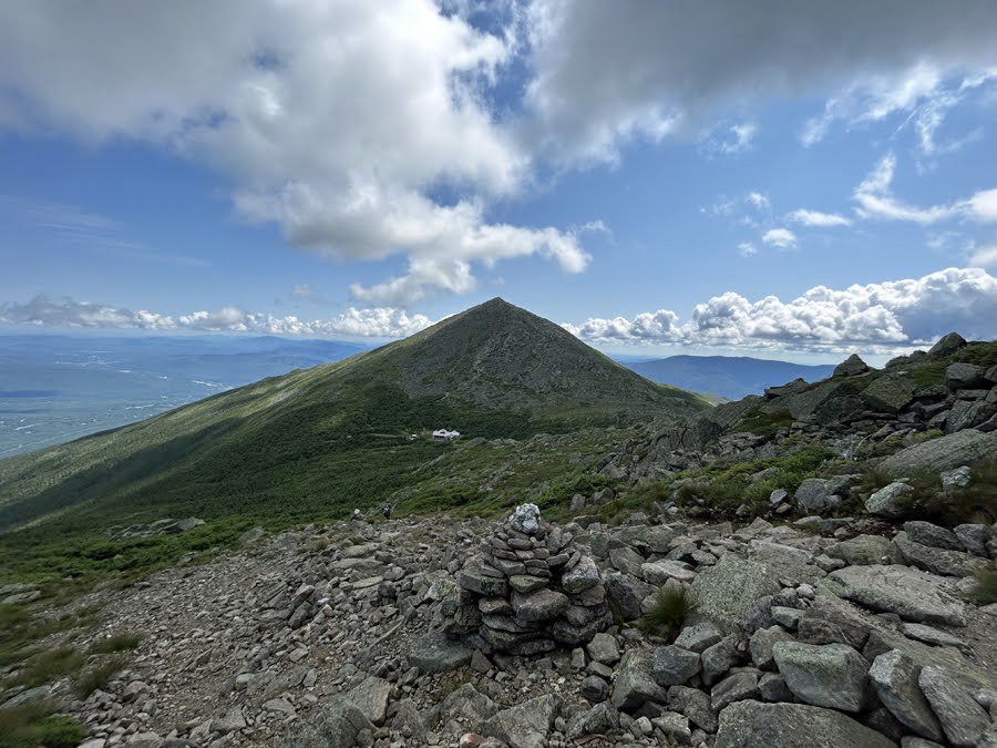
Sarge just north of the summit of Mount Liberty with Lincoln, Lafayette, and Garfield in the distance

Tuckerman Ravine

Leaves starting to change in the Bowl in Tuckerman Ravine

Glen Boulder Trail. Sun rising above Wildcat Ridge

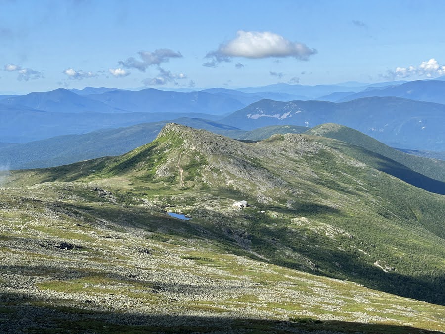
Sarge looking at the Southern Presidential Range from Mount Isolation

Mount Isolation

Summer 48 finish on Isolation!
9/21/24
Total Miles: 24.5 (11,500' elevation gained)
- On the final day of summer I headed to Bowman for a big day out traveling over some of the lighter used trails in the Presidential Range, (Sphinx, Great Gulf, Wamsutta, Buttress, King Ravine, and Israel Ridge).
- I started out with a long approach to Mount Jefferson via the Castle Trail. The trail starts off with good footing and gentle grades for the first two miles before steeply rising to a beautiful knoll through softwoods until just below treeline. The last mile and a half is a mix of steep grades up and along the castellated ridge before heading through a boulder field below the summit cone.

Below treeline on Castle Trail

Looking down at the first Castle along the Castellated Ridge

Watching undercast floating in the Great Gulf from Mount Jefferson's summit
- Sphinx Trail is (or was) my adopted trail, not sure if it still is as I have been trying to give it away for the past five years but the AMC still sends me relevant trail adopter emails. Anyway, the trail is holding up well, the only spots that need some love are above treeline there needs to be one or two small cairns built for a better line of sight for ease of following, just above the mossy wet rock wall ledge some brushing back of the trail is needed, and some water bar clearing midway down the trail.
- The highlight of the Sphinx Trail is it gets you to the floor of the Great Gulf quickly, 1.1 miles, and there are two attractive cascades which were running low with the recent lack of rain. Footing is not great below treeline as there is one section that travels through a brook and other spots have some tricky footing. I'd say only the last quarter mile is pretty tame, so if you like rough and rugged than this trail is for you!

Monticello Lawn

Sphinx Col

Undercast starting to break up as I head down into the Great Gulf

Cascade on the Sphinx Trail. Usually it is more impressive but with the lack of rain it's running quite low
- Next up was the Great Gulf Trail to the summit of Mount Washington. After and easy mile of moderate grades the trail passes by Spaulding Lake where you can get a great view of the huge bowl that makes up the Great Gulf Headwall. From the lake the trail gains around 1600' in just 0.75 miles. It's a steep climb, first up and around huge boulders and then over loose rocks of all sizes. It is a grind but well worth it as views are tremendous.
- The transition from solitude to civilization is a quick one once the trail tops out above the headwall, the Cog Railroad is reached a few hundred feet from where the Great Gulf Trail ends at the Gulfside Trail junction. From here it's just a rock hop skip and a jump to the summit of Mount Washington.

Weetamoo Cascade along the Great Gulf Trail

Spaulding Lake

Loose and steep Great Gulf headwall

Colors changing fast in the Great Gulf with Jefferson, Adams, and Madison rising high above

Undercast floating into the Great Gulf

Summit Observatory

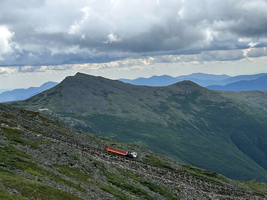
Cog Railway
- At the summit I grabbed some food, refilled water, chugged Gatorade, and warmed up inside. The crowds had not swarmed the summit yet so it was peaceful lounging around for ten minutes before getting back on trail or in this case road as in the Auto Road. Usually, I head down Nelson Crag and Alpine Garden Trail to the Wamsutta Trail but I figured I'd give my legs a break from knee hammering rocks and pounded pavement for 1.5 miles.
- Wamsutta Trail is another lightly used trail that is grown in near the top but is very well maintained for 95% of its length. There are a few gnarly but fun spots to negotiate below treeline but for the most part it is easier than most trails in the Great Gulf.

Mount Washington Auto Road

Descending the Wamsutta Trail with Mount Jefferson directly ahead
- After bottoming out in the Great Gulf for the second time I traveled along the Six Husbands Trail for 0.5 miles and then hooked onto the Buttress Trail for what was the longest 2.2 miles of the day. The trail starts and ends with a bang, great views, but most of the trail is in the woods and feels like a time warp with a few very overgrown spots with tough to see ankle twisting boobie traps. It was the low point of the day for me, energy levels were falling and it was quite warm in the woods. Thankfully, towards the end of the trail I ran into a couple of friendly faces, Sue and Al, and we chatted it up for a few minutes before heading to Madison Spring Hut for baked goods before going our separate ways.

West Branch Peabody River crossing at the start of the Six Husbands Trail. Lowest I've ever seen this crossing.

View of The Great Gulf and Jefferson Ravine from the talus field on Buttress Trail

Me informing Sue about Madison Spring Hut having the best selection of baked goods out of all the huts during the 2024 season!

Star Lake, almost bone dry, wow!
- Feeling rejuvenated I made quick work of the short out and back to Madison's summit, Airline Cutoff, and Airline Trail, before carefully picking my way down the notoriously steep 0.4 miles of the Chemin Des Dames to the floor of King Ravine. At this point I was 9300' of elevation gain into the day so being extra cautious on my last rugged descent on tired legs to avoid a bad fall was the name of the game.
- After safely navigating Chemin Des Dames I was ready for one last gut punch of ascent up King Ravine headwall on my way to Mount Adam's summit, a mere 1.5 miles and 2,200', nothing to it!
- I bypassed the Subway and Ice Cave side links of the trail, as much as I enjoy crawling over, under, and around the boulders, staying on the "Elevated" portion of the main trail was an easy decision to make on tiring legs.
- Just like the Great Gulf headwall, King Ravine has incredible views the higher it goes. Birch tree leaves are quickly changing color leaving a golden pattern woven in with the green pine along the floor of the ravine.
- Once I topped out of the King Ravine I joined the Airline Trail up to the Summit. The final two hundred feet I slowed down quite a bit so when I reached the top I took a much needed ten-minute break to get my strength back before the final 5.5 mile descent back to Bowman.

Mount Madison Summit

King Ravine

The "Gateway" final pitch before gaining the Durand Ridge

Madison Spring Hut

- Last but not least was the final section of my final summer hike/run, Israel Ridge Path. It coincides with Gulfside Trail from Thunderstorm Junction to Adams IV before curving high above Castle Ravine as it slowly drops below treeline. The final three + miles was over forgiving footing through beautiful woods blanketed in fallen Birch leaves. It was a much welcomed finish to the 25 miles adventure over mostly knee hammering rocks, time flew by as I made it back to Bowman just over eight and a half hours after starting.
- Back at the Jeep I cleaned myself off and relaxed for quite a while before heading back to Gorham to relax with the Dood. A perfect way to end another successful summer rock hopping above treeline!

Gulfside Trail / Israel Ridge Path with Mount Jefferson, Clay, and Washington in view.

Israel Ridge Trail, lightly used and heaven on earth for your feet!