
Date of Hike: 9/28/13
Old Bridle Path: 2.9 miles
|
Greenleaf Trail: 1.1 miles
|
Franconia Ridge Trail: 0.3 miles
|
Lincoln Slide: 2.2 miles
|
Lincoln Brook Trail: 1.0 miles
|
Owl's Head Path: 2.4 miles
|
Lincoln Brook Trail: 3.5 miles
|
Franconia Brook Trail: 2.2 miles
|
Garfield Ridge Trail: 4.4 miles
|
Franocnia Ridge Trail: 1.7 miles
|
Falling Waters Trail: 3.2 miles
| |
Total Miles: 25.0 ish
|
Elevation Gained: 10,350 feet
|
- On Saturday I jumped on I-95 in RI at 3:30 a.m. and headed to Franconia Notch for one of my 'Endurance Hikes.' My route for the day would start and finish at Lafayette Place parking for the Old Bridle Path and Falling Waters trailhead. The weather was going to be perfect and in just a few hours the parking lot and I-93 would be lined with cars with hundreds of hikers doing the classic Franconia Ridge Loop.
- The temps were crisp and cool at 6:30 in the morning as I made my way up the Old Bridle Path through the Agonies to Greenleaf Hut. I stopped in at the hut to restock my water, eat some energy gummies, and put on my long sleeve shirt and light mittens. I was pumped to head up to Lafayette's summit early in the morning, I got to enjoy the whole hike up to the summit and the summit itself by myself which is a rarity on a Saturday in the fall.
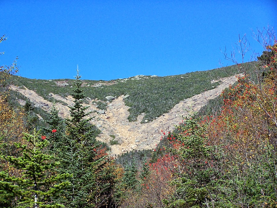
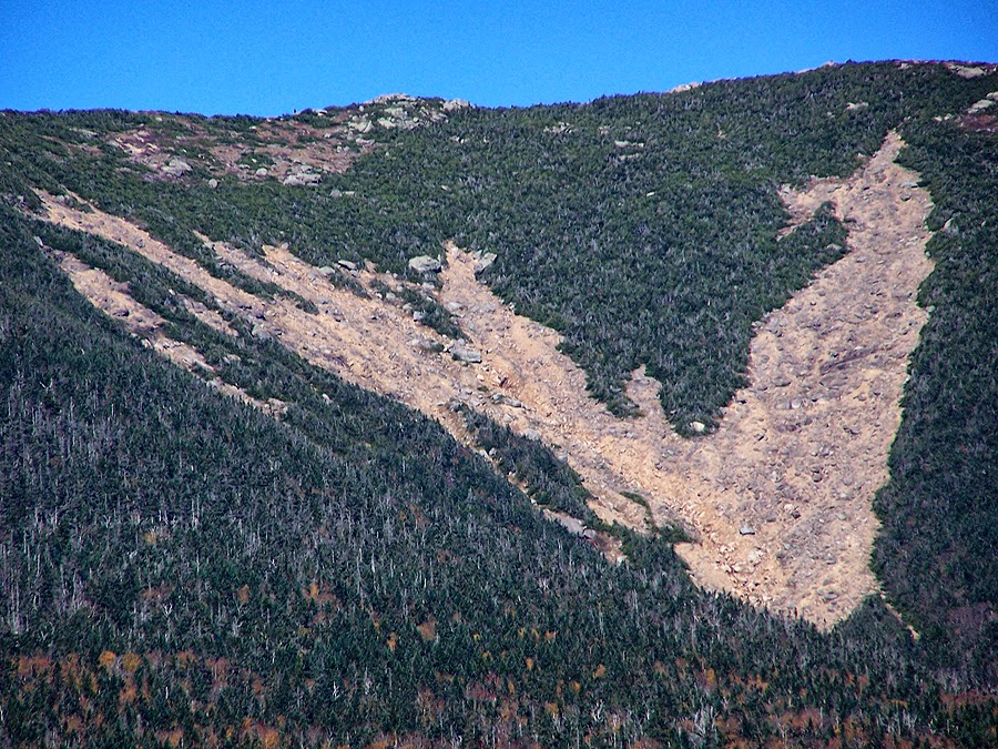
- From Lafayette I headed south on the Franconia Ridge trail toward North Lincoln, AKA Mount Truman. Just before summiting Mount Truman I took a left off the trail and skirted around the scrub and found a decent path that lead me to the top of the Lincoln/Truman Slides.
- The slide was pretty freaking cool, it's a bigger version of the South Slide on Mount Tripyramid with a lot of loose gravel and rocks. Since it doesn't see much use it's always moving under foot in places but it's never dangerous as long as you use caution and a little common sense.- The slide starts out really wide then funnels into a drainage where the loose rocks change to boulders with some slab and a stream begins to flow. When I reached the stream part of the slide I was back in the woods and put on my long pants to avoid getting scratched up while jumping out of the stream into the woods on the bushwhack.
- I basically followed the stream the whole way for my bushwhack. Sometimes I would walk directly in the stream on rocks or to the side of the stream on rocks or the banks. Other times I'd head into the woods anywhere from ten to fifty feet away from the stream. The woods were only thick in a few places and as the stream leveled out the woods opened up and I'd walk freely and even jog through a few sections. I'd always end up dropping back down to the stream to check it out and walk through it where passable.
- I kept close to the stream and then the stream became a brook that was much bigger and the slope of the bank became steeper. I kept diagonally crossing the slope up and down until I looked up and saw a big mound of mass rising high above me and realized, that's Owl's Head! So I dropped down to the brook, which became apparent to me that it was the Lincoln Brook and easily crossed it, went up an embankment for a few minutes until I just stepped out of the woods and onto the Lincoln Brook Trail! It was a much easier bushwhack from the bottom of the slide than I expected, I was able to avoid the swamps that some hikers stumble into and didn't have any issues finding the Lincoln Brook Trail.
- I was happy to be on the Lincoln Brook Trail as I have never been on it north of the Owl's Head Slide to just before the height of land. I was about a mile north of the slide and the trail was much easier to follow than all the horror stories I had heard. Once again, just watching your surroundings and being careful helps navigate lightly used trails like these. I started running into hikers just as I reached the Owl's Head Slide.
- The hike up to the ridge is pretty steep, the views from the slide are unique and beautiful on an autumn day during foliage. Owl's Head is one of my favorite mountains, it gets a bad rep from hikers who only head there once for the 48 - 4,000 footer patch. But if you go back again and again it becomes a favorite of many. The trails out to Owl's Head and the history of the logging that happened in the Pemigewasset Wildernesss during the early twentieth century is pretty amazing. You get to hike into and out of history, deep in the middle of nowhere!
- At the summit I thought about bushwhacking back down to the Lincoln Brook Trail, which I had done back in 2009 but for today I wanted to back track down the slide and hike the rest of the Lincoln Brook Trail that I have never been on before. There was probably only about a half mile of new section of trail for me but it was pretty cool to hike along the Lincoln Brook Trail and wrap around 'Owlie' as I made my way to Thirteen Falls. The Lincoln Brook Trail has had some decent trail work done, there are a couple of new bog bridges, and lots of little trees cut from the trail. The trail is still muddy in spots but compared to, let's say, some Adirondacks trails, it's in great shape!
- At Thirteen Falls I jumped on the Franconia Brook Trail. The trail follows the Franconia Brook through pine and birch trees and was much easier and gradual than I remember. The trail doesn't start to gain serious elevation until about half way through it and even then it never got really steep as it topped out in a col north of Mount Garfield.
- From here is was 4.4 miles on my Kryptonite, the Garfield Ridge Trail. The weather was very warm as I made my way past the dry waterfall section, the tentsite spur, and the Garfield Trail junction on my way to the summit. As I pushed up the last hundred feet or so I was told about three times, "You're almost there buddy." I must have looked like death, I felt fine but probably smelled really bad, those poor people!
- The summit had great views, I didn't stay to long before dropping back down a couple of thousand feet before heading back up a few thousand to Mount Lafayette. The Garfield Ridge Trail ended up being tamer than it has in the past. After years of being abused by it, once when I was nine, my first Hut to Hut attempt, breaking my camera on a Pemi Loop, I have become used to it and it's no longer a pain in the butt. It took twenty-five years but I finally defeated it!
- As I approached Mount Lafayette all I saw was great views and dozens, then hundreds of people hiking up, hiking down, and milling around. I hit Mount Lafayette's summit at 3 p.m. It was a zoo. I didn't even bother to try and keep count but it was probably around two hundred people I passed heading to Little Haystack and then down Falling Water back to the car. I jogged and rock hopped most of it, never running up on anyone and being nice and everyone let me pass. It was a weird way to end a hike, I had seen basically no one from Greenleaf Hut to just below Mount Garfield, not many people along the GRT until closing in on Mount Lafayette and then hundreds of people. I like most of the tourist hikers, since I used to be one. It's nice to see so many people enjoying one of the greatest hikes around!
- Back at the car I stretched for a good half hour, headed to Dunks for a large iced coffee before making my way to Twin Mountain to meet Bob & Geri for an incredible dinner at the Northern Embers. After dinner I made a nice fire at my tent site off Little Haystack road and rested for Sunday's 17 + mile trail run with B&G&D, Denise, and Steve!
Start: 6:35 a.m. / Lafayette: 8:05 a.m. / Owl's Head: 10:25 a.m. / 13 Falls: 12:05 p.m. / Garfield: 1:35 p.m. / Lafayette: 3:00 p.m. / Lincoln: 3:20 p.m. / Finished: 4:35 p.m.

My route for the day: Not an exact track, I added the lines in Photoshop :)

Mount Lincoln from an outlook along the Old Bridle Path

The 'Agonies'

Greenleaf Hut and Mount Lafayette

Eagle Lake and Mount Lafayette

Low clouds north of the Franconia Notch

Cannon Mountain from the Greenleaf Trail just below Mount Lafayette's summit

Lonesome Lake with North and South Kinsman

Echo Lake

Low cloud cover near Bethlehem

Mount Lafayette Summit

Mount Garfield, Galehead, South and North Twin

Rock buddies enjoying the early morning view from the old foundation on the summit

Classic Franconia Ridge Shot

Next stop, Owl's Head!

Top of the Lincoln/Truman Slides

Mount Lincoln from the slide

Looking down the Lincoln slide

The slide narrows and becomes a drainage

Looking up the Lincoln Slide

Loose gravel and jumbled rocks of the slide

The slide becomes a stream

Following the stream into the Lincoln Brook Valley of the Pemigewasset Wilderness

A nice cascade along the stream
Looking back up at the Lincoln / Truman Slides

Truman Branch of the slide

Truman Slide

Bushwhacking off the stream was thick in some spots

Back to hiking in the stream

Bottoming out along the stream

Open bushwhack down low

Another cascade, closing in on the Lincoln Brook

Popping out on the Lincoln Brook Trail!

Lincoln Brook

Owl's Head Path Junction

Bottom of the Owl's Head Slide

Franconia Ridge from the Owl's Head Slide
Lincoln and Truman Slides

Close up on the Truman Slide

Lincoln Brook Valley

Mount Liberty and Flume behind that 'bump' in the Pemi

Hiking along the ridge

Old summit tree

New Summit Cairn

Mount Lincoln is on the left, Mount Truman is in the middle, Mount Lafayette is on the right

Lincoln / Truman Slides

Truman Slide

Owl's Head Slide

Lincoln Brook Trail

Old railroad grades along the Lincoln Brook Trail

Some wet section to be navigated

Beautiful Railroad Grades on the Lincoln Brook Trail

Lincoln Brook Trail

A nice mossy section along the Lincoln Brook Trail

Lincoln Brook Trail

Lincoln Brook Trail

Lincoln Brook Trail

Heading down to Thirteen Falls

A little gorge on the Lincoln Brook

Lincoln Brook

Lincoln Brook

Foliage Blanket!

Thirteen Falls

Franconia Brook

Franconia Brook Trail

Old campsite on the Franconia Brook Trail

Pemi Wilderness Boundary

Garfield Ridge Trail

Owl's Head from Mount Garfield

Mount Lafayette

Mount Liberty and Flume Mountain off in the distance

Galehead and the Twin Range

Galehead Hut

Franconia Brook Valley

Twin Mountain

Mount Garfield Summit Area

Garfield Ridge Trail

Garfield Pond

Garfield Ridge Trail

Hitting the alpine zone on the north shoulders of Mount Lafayette

Hiking up above treeline

Fall in the White Mountains

Garfield Ridge Trail
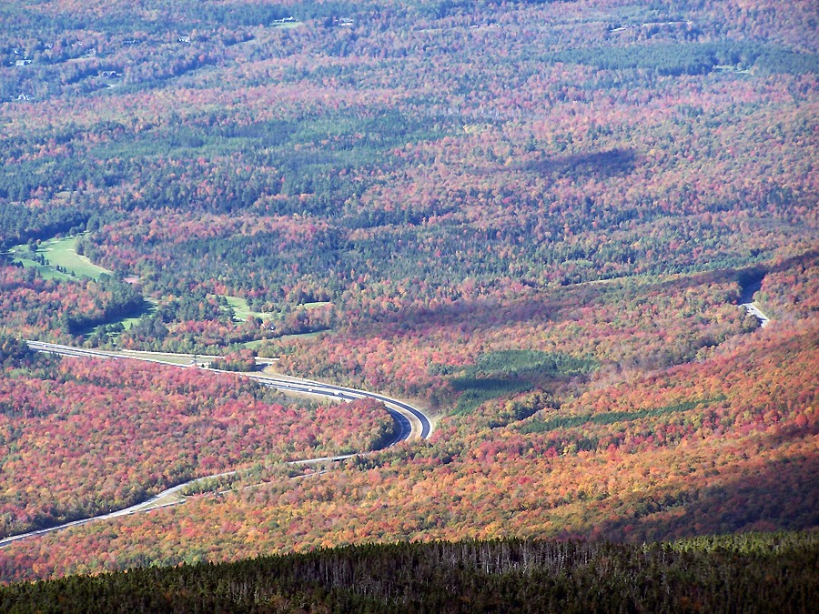
I-93 and Route 3

Twin Range

Bonds

Owl's Head

Greenleaf Hut, Cannon Mountain and the Kinsman Ridge

Mount Garfield to Galehead, to the twin Range

Mount Garfield

Owl's Head

Lincoln Brook Valley

The conga line down the Greenleaf Trail

Mount Lafayette Summit

The Franconia Ridge

Mount Lafayette

Looking down to the swamps of the Lincoln Brook

Top of the Lincoln / Truman Slides

Bottom of the Lincoln / Truman Slides

Mount Lafayette

Owl's Head Slide

Owl's Head

Mount Cannon

Franconia Notch

Franconia Notch

Owl's Head

Lincoln Slide

Mount Lincoln

Mount Liberty and Flume Mountain

Mount Cannon

Greenleaf Hut

North and South Kinsman

Falling waters Trail cascade
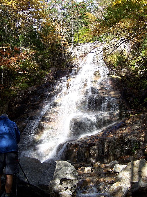
Cloudland Falls

Staircase Falls

Cannon Mountain and the Jeep Bad Ass from the Trailhead!
What a trip! Love the foliage blanket shot
ReplyDeleteThanks Anonymous! My camera is kind of old but still takes great shots. I do have to run it through photoshop to bring out the colors but try to keep it as true as what I see with my eye while hiking.
ReplyDeleteHave a great fall hiking!
Chris, how I envy your endurance! Words like "awesome" and "remarkable" really don't do justice to a feat such as this.
ReplyDeleteYour reports are consistently a pure delight to read.
John
Considering that your adventures and pictures are top notch, I really appreciate the kind words. Your comments always put a smile on my face!
DeleteThanks John!
Wow Chris. Great Trip and Pics. Thanks.
ReplyDeleteLittle Brown Mushroom
Thanks, I'm glad you enjoyed the report and pics!
DeleteAll I can say is amazing ! We live in CT, but love NH - can't wait to do some of that exploring as well. Thanks for taking us along. !
ReplyDeleteWendy
Thanks Wendy! I hope you guys are able to get in some great hiking this fall!, the Pemi is a really great area to get away from it all!
DeleteI went to college in CT, at Quinnipiac University and work out of my house here in RI for a company in CT (H. Pearce Real Estate)
Happy Hiking
-Chris
What a hike, thanks for writing about it. The pics are incredible!
ReplyDeleteThanks Anonymous!
Delete