
Date of Hikes: 6/3/16 & 6/4/16
Santanoni Road: 1.8 miles / Bradley Pond Trail: 1.8 miles / Old/New Express Trail: 1.8 miles / Santanoni Ridge Herd Path: 5.4 miles / Panther Brook Herd Path: 1.8 miles / Bradley Pond Trail: 2.5 miles / Santanoni Road: 1.8 miles
Total Miles: 16.9 (4,779 feet elevation gained)
Van Hovenberg Trail: 8.0 miles / Four Corners Trail: 1.0 miles / Skylight Spur Trail: 1.1 miles / Calamity Brook Trail: 0.3 miles / Gray Herd Path: 0.9 miles / Calamity Brook Trail: 1.7 miles / Cliff Herd Path: 2.5 miles / Calamity Brook Trail: 7.5 miles
Total Miles: 23.2 (5,856 feet elevation gained)
Trip Report:
- During the first weekend of June I drove over to the Adirondack High Peaks Wilderness in New York to meet up with my college roommate from my days at 'The College of the Quinnipiac University,' Tom Diaz. We lucked out and had some great weather, albeit humid with plenty of mud and bugs, the norm for ADK hiking!
- Diaz is working on his 46-R list, going into the weekend he had 23, after the weekend he is at 29. Our first target was the Santanoni Range, which includes three peaks on the list, Santanoni, Panther, and Couchsachraga (pronounced kook-sa-cra-ga, AKA coochie for short). I had not been to this range since 2011 and it was really fun to revisit them. The mud pit in the Coocie Col seemed bigger than in 2011, the bridges on the Bradley Pond Trail were in rough shape, one was totally gone while the other looked like it was about to fall over! The paths up to, along, and down from the ridge seemed the same, while the Bradley Pond Trail seemed muddier. All in all it was an excellent day out with pretty sweet views from Panther's summit ledges.
- Our second hike of the weekend had us hiking from South Meadows to Upper Works via Marcy, Skylight, Gray, and Cliff. Diaz had already hike Marcy, highest point in New York, and I have been up there a few times, but when you have great weather it's a no brainer, you head over the big one!
- The hike was straight forward over Marcy, down to Four Corners, and out and back to Skylight, but when we hit the Gray Herd Path things got mud and would only get more ridiculous! I had hiked Gray twice before, last time was in 2012, it seems a little more eroded than back then. Cliff I had only hiked once, in the rain with Diaz's brother, Chris, back in 2011 during a three day backpack, Diaz was with us but after going up and down Redfield he was spent so only Chris and I headed up Cliff's Cliffs. I remember it being a muddy mess but not too bad considering it had been raining. Well, either I mis-remembered or just forgot, but this herd path is a hell hole...of fun! It's muddy and beyond eroded and Cliff's Cliffs have mud in spots making for some interesting scrambles. We had a blast but this out and back beat did beat us up a little.
- From here we had a seven plus mile hiking death march out to Upper Works. As we hiked out it became apparent that the last mile or two wood be with headlamps, so not wanting to make the hike any longer than it was I unfortunately couldn't take Diaz through Flowed Lands to some of the places I explored off trail back in 2012. Also, his Achilles was in rough shape so I just wanted to get him back to Upper Works. Diaz is tough and battled it out over the final seven miles back to the car no worse for wear.
- We made it back to the car at 9PM and made the long drive back to the the hostel, it was an incredible all day adventure in the High Peaks and we are both looking forward to our next hike in the High Peaks as Diaz continues his quest to become a 46er. :)


 Our second hike of the weekend starts off along a very nice truck road for over two miles. I enjoy this approach better than leaving from the ADK LOJ, it's quieter and free to park. However, space is limited so get to the trailhead early.
 The truck road leads us to Marcy Dam, which was breached in 2011 during Tropical Storm Irene
 Marcy Dam. There used to be a bridge over the top that you could cross, it's no longer than and will not be rebuilt
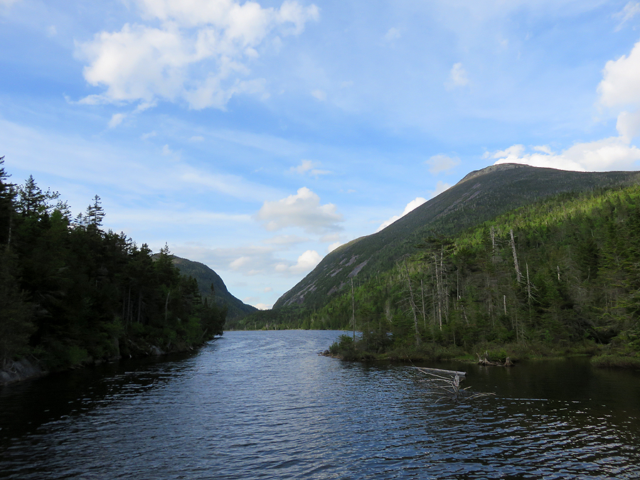
 View of Mount Colden and Avalanche Mountain. This used to be filled with water before the dam was breached. This will eventually turn into a mini Flowed Lands
 A forest ranger stands and admires Wright Peak while we head off along the Van Hovenberg Trail
 Indian Falls, what a great spot with an phenomenal view of the MacIntyre Range
 Me with Wright, Algonquin, and Iroquois peaks behind me (R to L)
 Breaking above treeline for the last half mile up to the highest point in New York. A great section of trail!
 Diaz makes his way up toward the summit
 Looking back at the Great Range
 Diaz heads up the slab covered alpine zone of Mount Marcy. Basin, Saddleback, Gothics, Pyramid, Giant, Rocky Peak Ridge looming behind him
 Mount Marcy's summit is wide open with 360 degree views.
 Gray Peak, I refer to it as Mount Marcy's 'creeper peak' as it just sits there lurking down below!
 Gray Peak and Lake Tear of the Clouds
 Mount Colden and the MacIntyre Range
 Diaz heads down the trail that leads to Four Corners
 Haystack Mountain (top), Mount Skylight (bottom)
 Panther Gorge with Haystack rising steeply above it
 One of my favorite summits, Mount Skylight
 Mount Skylight (top), Gray Peak (bottom)
 Mount Redfield and Cliff Mountain lying low to the west. Santanoni Range is off in the distance, too.

Mount Redfield and it's secluded Moss Pond as seen from Gray Peak's herd path
 The eroded steep mess that is the Gray Peak herd path. I've been here twice, it's much worse than I remember!
 Lake Tear of the Clouds, the highest water source of the Hudson River!
 The cairn marking the split for the Redfield and Cliff herd paths

 Diaz scrambles up and eroded muddy mess of a path
 Diaz scrambling up Cliff's cliffs with a pretty great view directly behind him...wait until you get up here to look!
 One of the best views of the day! From what I can tell, Marcy, Gray, Skylight in view with an un-named sub peak of Redfield directly in front.
 Diaz sliding down some slab covered in mud. This was sketchy going up and even sketchier going down as there is mud under us making footing a little difficult
 More descending the muddy and rocky path
 The lowest cliff on Cliff
 Now that is erosion! The herd path bangs a right directly behind Diaz, the Old Twin Brook Trail continues straight ahead (abandoned in 1986). From what I am told it's one of worst whack's over an old trail around, just littered with horrifying blowdowns.
 After getting back to the trail we had a seven mile hiker death march back to Upper Works. This is a great stretch of trail, very pleasant and pretty as it nears Lake Colden Dam
 Mount Colden, Avalanche Mountain, and Avalanche Pass as seen from the Lake Colden Dam
 One of my favorite places in the Dak's, the Lake Colden Dam.
 Followed by my favorite spot in the Dak's, Flowed Lands!
 Mount Colden as seen from Flowed Lands :)
 Henderson Lake and the Calamity. In the late 1800's a few locals were out prospecting and one was accidentally shot to death here
 Signs spotted from South Meadows to Mount Marcy
 Signs spotted from Mount Marcy to Upper Works
Santanoni Road: 1.8 miles / Bradley Pond Trail: 1.8 miles / Old/New Express Trail: 1.8 miles / Santanoni Ridge Herd Path: 5.4 miles / Panther Brook Herd Path: 1.8 miles / Bradley Pond Trail: 2.5 miles / Santanoni Road: 1.8 miles
Total Miles: 16.9 (4,779 feet elevation gained)
Van Hovenberg Trail: 8.0 miles / Four Corners Trail: 1.0 miles / Skylight Spur Trail: 1.1 miles / Calamity Brook Trail: 0.3 miles / Gray Herd Path: 0.9 miles / Calamity Brook Trail: 1.7 miles / Cliff Herd Path: 2.5 miles / Calamity Brook Trail: 7.5 miles
Total Miles: 23.2 (5,856 feet elevation gained)
Trip Report:
- During the first weekend of June I drove over to the Adirondack High Peaks Wilderness in New York to meet up with my college roommate from my days at 'The College of the Quinnipiac University,' Tom Diaz. We lucked out and had some great weather, albeit humid with plenty of mud and bugs, the norm for ADK hiking!
- Diaz is working on his 46-R list, going into the weekend he had 23, after the weekend he is at 29. Our first target was the Santanoni Range, which includes three peaks on the list, Santanoni, Panther, and Couchsachraga (pronounced kook-sa-cra-ga, AKA coochie for short). I had not been to this range since 2011 and it was really fun to revisit them. The mud pit in the Coocie Col seemed bigger than in 2011, the bridges on the Bradley Pond Trail were in rough shape, one was totally gone while the other looked like it was about to fall over! The paths up to, along, and down from the ridge seemed the same, while the Bradley Pond Trail seemed muddier. All in all it was an excellent day out with pretty sweet views from Panther's summit ledges.
- Our second hike of the weekend had us hiking from South Meadows to Upper Works via Marcy, Skylight, Gray, and Cliff. Diaz had already hike Marcy, highest point in New York, and I have been up there a few times, but when you have great weather it's a no brainer, you head over the big one!
- The hike was straight forward over Marcy, down to Four Corners, and out and back to Skylight, but when we hit the Gray Herd Path things got mud and would only get more ridiculous! I had hiked Gray twice before, last time was in 2012, it seems a little more eroded than back then. Cliff I had only hiked once, in the rain with Diaz's brother, Chris, back in 2011 during a three day backpack, Diaz was with us but after going up and down Redfield he was spent so only Chris and I headed up Cliff's Cliffs. I remember it being a muddy mess but not too bad considering it had been raining. Well, either I mis-remembered or just forgot, but this herd path is a hell hole...of fun! It's muddy and beyond eroded and Cliff's Cliffs have mud in spots making for some interesting scrambles. We had a blast but this out and back beat did beat us up a little.
- From here we had a seven plus mile hiking death march out to Upper Works. As we hiked out it became apparent that the last mile or two wood be with headlamps, so not wanting to make the hike any longer than it was I unfortunately couldn't take Diaz through Flowed Lands to some of the places I explored off trail back in 2012. Also, his Achilles was in rough shape so I just wanted to get him back to Upper Works. Diaz is tough and battled it out over the final seven miles back to the car no worse for wear.
- We made it back to the car at 9PM and made the long drive back to the the hostel, it was an incredible all day adventure in the High Peaks and we are both looking forward to our next hike in the High Peaks as Diaz continues his quest to become a 46er. :)
The two routes for the hikes. I refer to the Bradley Pond Trailhead as 'Middle Works' even though it's not. I just call it that because it's in the middle of the road that leads to Upper Works
Elevation over distance profile for hike #1 (Santanoni Range)
Elevation over distance profile for hike #2 (Mary-Skylight-Gray-Cliff)
For the Santanoni Range hike we start off over an old forest road for the first just under two miles
The old bridges at the beginning of the Bradley Pond Trail over Santanoni Brook have seen better days. As you can clearly see, the first bridge is washed out.
Bridge #2 does not have much longer to live, it's in rough shape!
For the most part the only official trail we were on was muddier and worse than the herd paths.
After another two miles on the Bradley Pond Trail we bang a left and make our way up the Old/New Express Trail which is a herd path. Here Diaz scrambles up some steep slab, which when I was last here in 2011 had a rope for assistance, not anymore!
View from an outlook near Santanoni Peak summit looking down to Bradley Pond
The Seward Range and Seymour to the northwest
Looking down at Couchsachraga, which is almost a thousand feet below Santa's elevation.
Looking across to Panther Peak. The hike between Santa and Panther is pretty easy. Panther has excellent ledges for views.
Diaz makes his way to Times Square, he looks thrilled! Herald Square is just a hundred feet east of this spot. I've wondered at time if they'll ever 'merge' Times and Herald Square, making for one three way junction, not two so close to each other.
The only view from the herd path to Couchie, and it's a good one as the Sward Range, (Emmons, Donaldson, Seward), and Seymour are in view. The remote Ouluska Pass separates Seward and Seymour mountains. The Final section of the Northville-Placid Trail (NPT) travels through the valley below these mountains and ends in the Town of Lake Placid just to the north.
The Couchsahraga mud put. It's famous and well known to all High Peak peakbaggers. Some loathe this spot, I absolutely love it!
Diaz looks for a way around the muck...not happening!
He carefully balances himself with a wimpy stick so he doesn't fall knee deep into the mud
What a mess!
On the way back he finds a sturdier walking stick to help with the balancing act...he makes it out mostly unscathed!
Santanoni Peak (top), Couchsachraga Peak (bottom) from Panther's ledges, a great spot to take it all in and look back from where you have spent the majority of the day.
At 4,600 feet, Santanoni Peak dominates the range
Heading down the herd path in Panther Brook drainage. It's pretty friggan rough and has a PUD mixed in towards the bottom around Bradley Pond
View of the Central High peaks from an obstructed outlook on top of a big boulder heading down the Panther Brook herd path
Beaver swamp, this is where the herd path begins, it leaves at a left from the Bradley Pond Trail at a small cairn
The hike back out was pretty muddy, some newish bog bridges have been installed since the last time I was here in 2011
Diaz taking a well deserved break on the bridge over the Santanoni Brook before heading back to the Jeep
Signs spotted along the way
---------------------------------------------------------------------------------------
Mount Redfield and it's secluded Moss Pond as seen from Gray Peak's herd path
The start of the Cliff herd path, that nice section on the left will look like what is on the right in a few years, when a herd path is not properly maintained as an official trail it has no way of sustaining itself
Damn, this brings back some good memories! Great post!
ReplyDeleteThanks Rick, hope you can get back up there again to enjoy that mud!!
DeleteI still have a big list of things I want to do in the Dacks, so I will most certainly be returning in the next year or three! However, this Fall (early October) I'll be back in the Whites with my buddy Peter again. Really looking forward to that, which reminds me - I might send you a private Facebook message with a shuttle related question if you don't mind?
DeleteSounds good to me, I will happily help out in anyway possible. :)
Delete