
Click on mountain to view report / click here to view image gallery


Date
|
Mountain(s)
|
Trails
|
Miles
|
Elevation Gain
|
12/10/13
|
Glencliff Trail, Moosilauke Carriage Road
|
7.6
|
3,300 feet
| |
12/8/13
|
Hancock Notch Trail, Cedar Brook Trail, Hancock Loop Trail
|
9.8
|
2,700 feet
| |
12/7/13
|
Mount Tecumseh Trail
|
5.0
|
2,200 feet
| |
11/30/13
|
Old Bridle Path, Greenleaf Trail, Franconia Ridge Trail, Falling Waters Trail, Kinsman ridge Trail
|
13.4
|
6,100 feet
| |
11/29/13
|
Crawford Path, Webster Cliff Trail, Webster-Jackson Trail, Route 302
|
8.3
|
2,700 feet
| |
11/16/13
|
Zealand Trail, Twinway, Bondcliff Trail, West Bond Spur, Lincoln Woods Trail
|
19.7
|
4,000 feet
| |
11/11/13
|
Starr King Trail
|
7.2
|
2,650 feet
| |
11/10/13
|
Nineteen-Mile Brook Trail, Carter Dome Trail, Carter-Moriah Trail
|
12.6
|
3,750 feet
| |
11/9/13
|
Lincoln Woods Trail, Franconia Brook Trail, Bushwhack
|
17.2
|
2,250 feet
| |
11/2/13
|
Mount Mitchell Trail
|
12.0
|
3,700 feet
| |
10/21/13
|
Old Bridle Path, Greenleaf Trail, Franconia Ridge Trail, Lincoln Slide Bushwhack, Lincoln Brook Trail, Owl's Head Path, Franconia Brook Trail, Lincoln Woods Trail
|
17.5
|
5,200 feet
| |
10/20/13
|
Brookway Ski Trail, Lower Walking Boss Ski Trail, Upper Walking Boss Ski
Trail, Herd Path, Bushwhack
|
7.0
|
3,000 feet
| |
10/13/13
|
Tuckerman Ravine Trail, Crawford Path, Davis Path, Glen Boulder Trail, Direttissima
|
16.1
|
6,500 feet
| |
10/12/13
|
Valley Way, Osgood Trail, Gulfside Trail, Airline, Lowe's Path, Crawford Path, Monroe Loop Trail, Eisenhower Loop Trail, Webster-Cliff Trail
|
20.0
|
8,400 feet
| |
10/11/13
|
Mittersill-Cannon Trail / Mount Willard Trail
|
8.2
|
3,400 feet
| |
10/8/13
|
North Twin Trail, North Twin Spur, Twinway, Frost Trail, Garfield Ridge Trail, Gale River Trail
|
12.1
|
3,650 feet
| |
9/29/13
|
Zealand Trail, Ethan Pond Trail, Shoal Pond Trail, Carrigain Notch Trail, Desolation Trail, Signal Ridge Trail
|
17.0
|
3,250 feet
| |
9/28/13
|
Old Bridle Path, Greenleaf Trail, Franconia Ridge Trail, Lincoln Slide / Bushwhack, Lincoln Brook Trail, Owl's Head Slide Path, Franconia Brook Trail, Garfield Ridge Trail, Falling Waters Trail
|
25.0
|
10,350 feet
| |
9/23/13
|
Hancock Notch Trail, Cedar Brook Trail, Hancock Loop Trail
|
9.8
|
2,650 feet
| |
9/22/13
|
Mount Tecumseh Trail / Welch-Dickey Loop
|
9.4
|
4,050 feet
| |
9/21/13
|
Zealand Trail, Twinway, Bondcliff Trail, West Bond Spur, Lincoln Woods Trail
|
19.7
|
4,000 feet
| |
9/20/13
|
Ammonoosuc Ravine Trail, Monroe Loop Trail, Crawford Path, Gulfside Trail, Jewell Trail, Base Station Road
|
10.4
|
4,200 feet
| |
9/14/13
|
Flags on the 48: Lincoln Woods Trail, Osseo Trail, Franconia Ridge Trail
|
13.4
|
4,050 feet
| |
9/7/13
|
Old Speck Trail, Eyebrow Trail / Caps Ridge trail
|
12.7
|
5,700 feet
| |
9/6/13
|
Carter-Moriah Trail
|
9.0
|
3,400 feet
| |
9/5/13
|
Martson Trail, Mount Coe Trail
|
12.1
|
3,800 feet
| |
9/4/13
|
Helon Taylor Trail, Knife Edge, Saddle Trail, Northwest Basin Trail, Hamlin Ridge Trail, North Basin Trail, Chimney Pond Trail
|
11.0
|
4,150 feet
| |
9/3/13
|
Appalachian Trail
|
2.0
|
300 feet
| |
9/1/13
|
Gale River Trail, Bushwhack, Garfield Ridge Trail, Garfield Trail, Ski mobile Trails, old logging roads, Gale River Loop Road
|
10.0
|
2,900 feet
| |
8/31/13
|
Lincoln Woods Trail, Bondcliff Trail, West Bond Spur
|
22.8
|
4,800 feet
| |
8/25/13
|
Lincoln Woods Trail, Franconia Brook Trail, Twin Brook Trail, Frost Trail, Twinway, Bondcliff Trail
|
26.3
|
4,850 feet
| |
8/14/13
|
Zealand Trail, Ethan Pond Trail, Bushwhack, Thoreau Falls Trail, East Side Trail
|
17.9
|
1,800 feet
| |
8/10/13
|
Pinkham Road B, Pine Link, Howker Ridge, Osgood, Madison Gulf, Great Gulf, Six Husbands, Jefferson Loop, Gulfside, Ariline Cutoff, Airline, Chemin Des Dames, King Ravine, Lowe's Path, Grey Knob, Hinks, Spur, Randolph, Great Gully, Star Lake, Great Gulf Link, Campground Roads
|
32.0
|
15,000 feet
| |
8/9/13
|
Asquam Ridge, Beaver Brook, Gorge
|
9.5
|
2,600 feet
| |
8/3/13
|
Avalon, A-Z, Mount Tom Spur, Willey Range
|
10.0
|
3,250 feet
| |
8/2/13
|
Greeley Ponds Trail, Mount Osceola Trail
|
7.6
|
3,300 feet
| |
7/21/13
|
Crawford Path, Webster Cliff, Eisenhower Loop, Monroe Loop, Gulfside, Clay Loop, Jefferson Loop, Lowe's Path, Airline, Osgood
|
31.5
|
12,300 feet
| |
7/14/13
|
Greenleaf, Garfield Ridge, Skookumchuck
|
8.9
|
3,500 feet
| |
7/13/13
|
Tuckerman Ravine, Huntington Ravine, Nelson Crag, Great Gulf, Six Husbands, Buttress, Adams Slide, Star Lake, Lowe's Path, Gulfside, Jefferson Loop, Sphinx, Madison Gulf, Old Jackson Road
|
21.0
|
8,300 feet
| |
7/6/13
|
Lincoln Woods Trail, Osseo Trail, Franconia Ridge Trail, Garfield Ridge Trail, Twinway, West Bond Spur, Bondcliff Trail
|
32.5
|
9,500 feet
| |
7/5/13
|
Carter Ledge Trail, Middle Sister Trail
|
8.0
|
2,500 feet
| |
7/4/13
|
Champney Falls Trail, Piper Trail, Liberty Trail, Brook Trail, Bee Line Trail, Bolles Trail
|
10.0
|
3,200 feet
| |
7/1/13
|
Hancock Notch Trail, Cedar Brook Trail, Hancock Loop Trail
|
9.8
|
2,650 feet
| |
6/23/13
|
Avalon Trail, A-Z Trail, Mount Tom Spur, Willey Range Trail, Ethan Pond Trail, Kendron Flume Trail, Railroad Tracks
|
11.1
|
2,850 feet
| |
6/22/13
|
Route 16, Camp Dodge Cutoff, Imp Trail, North Carter Trail, Carter-Moriah Trail, Wildcat Ridge Trail, Ski Slopes
|
17.8
|
6,500 feet
| |
6/16/13
|
Caps Ridge Trail, Jefferson Loop, Gulfside Trail, Clay Loop, Crawford Path, Monroe Loop, Eisenhower Loop, Webster Cliff Trail, Webster-Jackson Trail, Route 302, Mount Clinton Road, Jefferson Notch Road
|
25.0
|
7,000 feet
| |
6/9/13
|
Asquam-Ridge Trail, Beaver Brook Trail, Bushwhack, Moosilauke Carriage Road, Snapper Trail, Gorge Brook Trail
|
9.6
|
2,600 feet
| |
6/2/13
|
Garfield Trail, Garfield Ridge Trail
|
10.0
|
3,000 feet
| |
5/31/13
|
Livermore Trail, Mount Tripyramid Trail
|
11.1
|
3,000 feet
| |
5/30/13
|
Lincoln Woods Trail, Bondcliff Trail, West Bond Spur
|
22.8
|
4,800 feet
| |
5/27/13
|
North Twin Trail, Bushwhack, North Twin Spur, Twinway, Lend-a-Hand Trail, Fire Warden's Trail
|
18.0
|
5,300 feet
| |
5/18/13
|
Tuckerman Ravine Trail, Huntington Ravine Trail, Alpine Garden Trail, Lion Head Trail
|
8.2
|
3,500 feet
| |
5/12/13
|
Mount Major Trail, Major-Straightback Link, Brook Trail
|
4.1
|
1,150 feet
| |
4/28/13
|
Lincoln Woods Trail, Bondcliff Trail, West Bond Spur
|
22.8
|
4,800 feet
| |
4/27/13
|
Old Bridle Path, Greenleaf Trail, Franconia Ridge Trail, Osseo Trail
|
14.5
|
4,750 feet
| |
4/21/13
|
Old Bridle Path, Greenleaf Trail, Franconia Ridge Trail, Falling Waters Trail
|
8.9
|
3,900 feet
| |
4/7/13
|
Greeley Ponds Trail, Mount Osceola Trail
|
7.6
|
3,300 feet
| |
4/6/13
|
Kinsman Ridge Trail, Fishin' Juimmy Trail, Lonesome Lake Trail, Dodge Cutoff, Hi-Cannon Trail, Franconia Notch Recreational Trail
|
14.8
|
5,150 feet
| |
3/9/13
|
Valley Way, Osgood Trail, Gulfside Trail, Lowe's Path, Jefferson Loop Trail, Snow-whack, Clay Loop Trail, Crawford Path, Monroe Loop Trail, Franklin Spur, Eisenhower Loop Trail, Webster Cliff Trail, Webster-Jackson Trail
|
22.5
|
8,660 feet
| |
2/26/13
|
Valley Way, Osgood Trail, Gulside Trail, Airline
|
10.4
|
5,050 feet
| |
2/17/13
|
Hancock Notch (no report)
|
Hancock Notch Trail, Cedar Brook Trail, Hancock Loop Trail
|
7.2
|
1,200 feet
|
2/16/13
|
Bike Path, Basin Bushwhack, Liberty Springs Trail, Franconia Ridge Trail
|
10.0
|
4,050 feet
| |
1/27/13
|
Lincoln Woods Trail, Black Pond Trail, Black Pond Bushwhack, Lincoln Brook Trail, Brutus Bushwhack, Owl's Head Path
|
17.0
|
3,250 feet
| |
1/26/13
|
Avalon Trail, A-Z trail, Mount Tom Spur, Willey Range Trail
|
10.0
|
3,250 feet
| |
1/19/13
|
Logging Roads, North Twin Trail, Mount Hale Fire Warden's Trail, Hale Brook Trail, Zealand Road, Route 302
|
10.0
|
2,000 feet
| |
-
|
-
|
141 'Official' 4,000 footers
|
879.9
|
281,200 feet
|

'The Gateway' - Topping out of King Ravine (August 10th)

The Knife Edge of Mount Katahdin (September 4th)

Hawthorne Falls (September 1st)

Bear Pond in Redrock Ravine (November 9th)

Sunset along the Gulfside Trail (September 20th)

Madison Springs Hut and Mount Madison (March 9th)

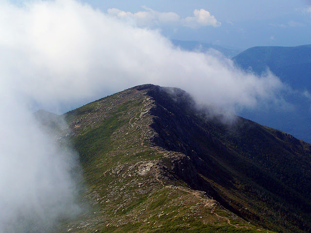
Cannon Mountain, North and South Kinsman above Lonesome Lake as seen from Old Bridle Path (November 30th)

Summit of Mount Mitchell (November 2nd)

Mittersill-Cannon Trail (October 11th)

Mount Eisenhower, Monroe, and Washington (July 21st)

Undercast flowing over the col between Mount Pierce and Eisenhower (October 12th)

Denise and Dusty finish the 48th, 4000 footer on Bondcliff (September 21st)

Webster Cliff Trail northern terminus just below the summit of Mount Pierce (November 29th)

Denise, Smantha, and Whitney charging up the Starr King Trail to Mount Waumbek (November 11)

Huntington Ravine: The Fan, Pinnacle and Central Gully (May 18th)

Lincoln / Truman Slides (September 28th)

Pemigewasset Wilderness: Shoal Pond Brook Valley to Zealand Notch (September 29th)

Isis says hello, cookie please! Carter Dome Trail (November 10th)

Tuckerman Ravine (October 13th)

The open ledges on Welch Mountain (September 22nd)

Leading Cole down the 'Chimney' in the Osceola / East Osceola Col (August 2nd)

Seahorse and Witch Slide from Coe Mountain (September 5th)

The Cog Train on the northern slopes of Mount Washington with Mount Jefferson behind it (July 13th)

Whitney kissing the Owl's Head summit cairn, her 48th and final 4,000 footer! Photo is Whitney's(October 21st)

Flume Mountain Summit, Flags on the 48 (September 14th)

West Bond from Mount Guyot (July 6th)

Lakes of the Clouds Hut and Mount Monroe (June 16th)

West Scar (October 20th)

Cedar Brook Trail (September 23rd)

Mount Guyot from the Twinway (May 27th)

Cole on the Whitewall Slide (August 14th)

Liberty / Brook Trail Junction (July 4th)

Greenleaf Hut and Mount Lafayette (April 21st)

Owl's Head as seen from Black Pond (January 27th)

Diaz scrambling up the North Slide of North Tripyramid (May 31st)

Franconia Ridge as seen from Lonesome Lake (April 6th)

Zealand Road (January 19th)

Cole and Murphy playing at the Hale Brook Trailhead (August 18th)

Franconia Ridge Trail, descending from Mount Liberty's Summit (February 16th)

Alton glissading down a small slide below East Osceola (April 7th)

Mount Tom Summit Area (January 27th)

Weather Warning sign on the Valley Way Trail (February 26th)

Mount Liberty and Flume Mountain from the Franconia Ridge Trail (April 27th)

Bondcliff Trail heading south toward Mount Bond (April 28th)

Beaver Pond off the Franconia Brook Trail (August 25th)

Alton helping Cole cross a small brook (Mount Major, May 12th)

Clouds rushing in over Bondcliff (August 31st)
Cole getting up close and personal on the Garfield Trail (June 2nd)

Bondcliff as seen from Mount Bond (May 30th)

Franconia Brook Valley with Mount Garfield (far right) Mount Lafayette and Lincoln (left side, right to left) November 16th

Moosilauke Carriage Road (A.T.) from the summit of Mount Moosilauke (June 9th)

Carter Notch Hut System as seen from The Carter-Moriah Trail (June 22nd)

Mount Webster from across Crawford Notch at the site of the old Mount Willard Section House (June 23rd)

North Branch of the Hancock Brook on the Cedar Brook Trail (July 3rd)

Cole cooling off in Hobbs Brook (July 5th)

The Garfield Ridge Trail just north of Mount Lafayette (July 14th)

Dion makes a friend at the Avalon / Willey Range Trail Junction (August 3rd)

Baker River on the Asquam-Ridge Trail (August 9th)

Old Speck Summit (September 7th)

Lower section of the North Twin Trail (October 8th)

Carter-Moriah Trail (September 6th)

Lenticular clouds above Monitcello Lawn (September 7th)

Mount Tecumseh Trail (December 7th)

Moosilauke Carriage Road (December 10th)

Amy navigating an icy brook crossing on the Hancock Notch Trail
I love these pics! What are you using for a camera? The glissading one is awesome!
ReplyDeleteHi Grant, glad you like the pics, thanks! I use a Cannon Powershot A3100. I have kind of beaten it up but it still is taking good pictures!
DeleteChris,
ReplyDeleteLove your blog. Your pictures inspired our hike last weekend up to Monroe. You are one of my go to blogs when deciding on where to hike in the White Mountains. Thank you for blogging and for your amazing photos.
Ann
Thanks Ann!
DeleteYour report and pics for your Monroe hike was great, I love that stretch of hiking the Crawford Path between Monroe and Eisenhower!
Your banner picture on top of your blog is not yours. It's Alton's picture from Facebook. You really shouldn't use other people's pictures and say they are yours.
ReplyDeleteHi Anonymous, The picture in question I took from a hike on 1/16/12. Alton has used a picture or two of mine as a Facebook cover photo in the past and has credited me with the picture. Your comment is very rude and I find it kind of pathetic that you are creeping around my blog for that very reason. Please do me a favor and don't view my blog, it's for hikers and friends and you are neither in my mind, and you're obviously not a friend of hers, too.
Delete-Chris