Showing posts with label South Twin Mountain. Show all posts

North Twin, South Twin, and Galehead Loop

Date of Hike: 3/8/15

Little River Herd Path: 1.0 miles  /  North Twin Trail: 4.3 miles  /  North Twin Spur:  1.2 miles  /  Twinway:  0.8 miles  /  Frost Trail:  0.8 miles  /  Garfield Ridge Trail: 0.6 miles  /  Gale River Trail: 3.8 miles  /  Corridor 11 & Corridor 11 Bypass: 5.0 miles
Total Miles 17.5  (4,624 feet elevation gained)

Trip Report ... In Pictures :)

7 a.m. at the end of Little River Road I jump on the herd path and head over to Haystack Road 
 I head along the North Twin Trail, bypassing the first two water crossings and hook onto a well used herd path.  Notice the ski tracks heading across the river, that's where the trail actually goes, I took a left at this spot onto the herd path.
 The Little River is just filled with snow
 With this much snow depth the route heads directly over the river!
 Back onto the North Twin Trail, then making the water crossing over the Little River
 Heading up to North Twin through the woods.  Lot of action in the trees down low, lots of snow up high
 View to the north down to the Sugarloafs
 To the west the sun is in a battle with the clouds!
 The trail corridor up to North Twin is fill to the tops of the trees
 North Twin summit.  The sun still trying to break through
 Hooked onto the North Twin Spur
 View from the North and South Twin col.  North Twin (left), South Twin (right)
 South Twin in the clear as I approach its summit cone
 Cool snow formations on the way to South Twin (top).  Looking back to North Twin (bottom)
 The final stretch to South Twin
 South Twin Summit
 Views over to Guyot and the Bonds (top).  Zealand (bottom)
South Twin Summit 
 Looking to the west across to the Franconia Ridge
 Heading down the Twinway. So much snow!!
 Dropping down back into the woods
 Galehead Hut and Galehead Mountain
 Frost Trail to the summit
 Nice view of South Twin and the hut from the Frost Trail outlook
 The summit of Galehead is still in the woods even with the high snow pack.  Nice view of South Twin near the summit of Galehead
 The descent back down the car via the Gale River Trail
 Trail reroute.  The Gale River Trail was rerouted to avoid two water crossings, this winter the old trail has been broken out
 Old Trail is in yellow, reroute is in red
 The mostly flat walk back to Gale River Loop Road
 I hook onto Gale River Loop Road, 'Corridor 11' and share the road with snowmobilers
 Signs spied along the way!
 Corridor 11 leads back to Haystack Road, I jump on that using the Corridor 11 bypass back to Little River Road
 An old fireplace and cobblestone cellar, the trailhead, and my Jeep :)
  Route for the day, Blue X's form left to right: North Twin, South Twin, Galehead.  Lower right red dot is where I hooked onto Gale River Loop Road, then Corridor 11 and Corridor 11 bypass back to the lower left red dot at the end of Little River Road. Click here for more details

Pemi Loop

Date of Hike: 5/12/12

Lincoln Woods Trail 1.4 miles 
Osseo Trail 4.1 miles
Franconia Ridge Trail 5.0 miles
Garfield Ridge Trail  6.6 miles
Twinway 2.8 miles
Bondcliff Trail 0.4 miles
West Bond Spur 1.0 miles
Bondcliff Trail 6.5 miles
Lincoln woods / Wilderness Trail 4.7 miles
32.5 miles
.
9,500 elevation gain

Trip Report:
- For most recent Pemi Loop, click here
- With almost all the snow gone from the ridges that make up the boundary of the Pemigewasset Wilderness it made Saturday a perfect day for a Pemi Loop.
- The forecast called for sunny skies with increasing clouds and high wind gusts out of the west/north west, temperatures in the 50's above treeline and near 70 in the woods.
- I started hiking at 5am and once again decided to hike it clockwise by heading up the Osseo Trail to the Franconia Ridge.  The Osseo Trail is one of the best maintained trail in the White Mountains, it has very moderate grades with one short steep section above the 'downlook' aided by well placed ladder steps to prevent trail erosion.  Basically the trail is the equivalent of being on a treadmill with the incline set at 10.
- As I ascended closer to Franconia Ridge I could hear the wind above me and as soon as I reached Flume Mountain's summit the wind hit me pretty good.  Luckily Flume and Liberty only have short section not shielded by the wind so it wasn't to bad and by the time I made it to Little Haystack the wind died down a little.
-  Hiking above treeline between Little Haystack to Lafayette early in the morning was a blast, I had the whole ridge to myself and the wind which was between 20-30mph felt refreshing until I reached the Garfield Ridge Trail at Mount Lafayette.  From here until dropping below treeline the wind was directly in my face and the gusts were higher so I stumbled around  a few times but still enjoyed the views.
- The Garfield Ridge Trail is much easier heading north than south and I had no issues at all as I summited Mount Garfield where after thirteen miles of hiking I finally ran into the first two hikers of the day who were relaxing out of the wind in the old fire tower foundation.  I took a nice fifteen minute break and chatted about hiking with them and then took off to my next stop Galehead Hut.
- In the two weeks since my last hike along this section of the ridge a lot has changed, other than the first hundred feet below Mount Garfield all the snow and ice is gone and the 'steeps' below the Garfield Ridge Tentsite is in full water fall mode make for a slippery but refreshing descent.
- Every time I hike the whole Garfield Ridge Trail I try and count the 'PUDS' (Pointless up and downs), usually I get to around five or six puds before I want to claw my eyeballs out so I just make up a number, this time I'll say 19, in honor of Josh Beckett because just like a PUD, him being on the Red Sox at this point is, well, pointless, here's to you 'Texas Toughguy'...you suck!
- I started running into more hikers as I approached the hut which is now open on a care-taker basis.  At the hut there were a bunch of people enjoying the views and relaxing before heading over to Galehead or the Twins.  At the hut I met Brian who was also doing a Pemi Loop as well, he caught sunrise on the Franconia Ridge which must have been a pretty awesome sight, nice meeting you Brian!
- From here I pushed it up the steep Twinway to South Twin's summit, along the way I ran into a father and daughter hiking up the Twinway.  The girl who is probably around five or so was having a blast as she was marching up the Twinway full speed ahead!
- On South Twin I went over to my secret spot out of the wind to have my lunch and stare at the Presidential Range rising high above before heading over toward Guyot and the Bonds.
- Now the clockwise Pemi Loop becomes much easier, once the back breaking ascent up to South Twin it's a breeze, if going counter clockwise the second half of the hike involves the steep ascent up to Garfield and the sufferfest up and over the false summits to Lafayette. On the other hand the clockwise direction involves the full force of the Lincoln Woods/Wilderness Trail at the end of the day but we'll get to that later.
- The Twinway had some dying monorail and slippery snow in places but nothing bad enough to give anyone fits.  Along the way I started running into dozens of hikers, some day hikers, some over-nighters, all enjoying themselves.
- Once I popped out above treeline and hooked onto the Bondcliff Trail over to Guyot the winds started picking up again but it was warm enough that I was able to stay in short sleeves.  One of my favorite sections is heading up to Guyot, views are killer and it's a very remote place. I still think Mount Guyot and Mount Clay for that matter should be official 4,000 footers, it sure seems like they fit within the 200' prominence rule.
- The wind kept getting stronger and stronger and by I made it up to West Bond it almost knocked me over, then as I headed down from Bond to Bondcliff it was blasting 40+ mph at times.  I was feeling the full force of the winds that rake across the ridgeline over Bondcliff...It was awesome!
- On the Boncliff summit flats I got out of the wind to take a nice break and enjoy the views one last time before dropping below treeline for the final part of the hike down the Bondcliff Trail to the Lincoln Woods/Wilderness Trail.
- Heading down the Bondcliff Trail my stomach started to feel bad, I had been eating and drinking but being up for this long and hiking I started craving different foods that would have made me feel better, unfortunately all I had was granola bars left so the five slices of pizza and cold beer I wish I had would have to wait!
- The two previous Pemi Loops I did I was mentally fried and started having conversations with imaginary friends while stubbing my toes along the Lincoln Woods/Wilderness Trail.  This time I felt extremely strong and breezed through to the trailhead with a smile on my face!
- Back at the car I changed up and stretched for a good twenty minutes before heading into town for a meal and a drink before making my way back to RI after an awesome day filled with views while crushing the Pemi Loop!
- On trail at 5am, Flume 6:50am, Liberty 7:20am, Little Haystack 8:05am, Lincoln, 8:30am, Lafayette 9am, Garfield 10:15am, Galehead Hut 11:40am, South Twin 12:25pm, Guyot 1:30pm, West Bond 1:55pm, Bond 2:25pm, Bondcliff 3pm, Lincoln Woods/Wilderness Trail 4:30pm, Finished 5:45pm

Pictures: Click here for all pictures

 Osseo Trail
 Osceola and Scar Ridge as seen from Flume Mountain
 Little Haystack, Mount Liberty and Flume Mountain
 Lonesome Lake and the Kinsman's from Franconia Ridge
 Kinsman's and Cannon Mountain
 Franconia Ridge
Franconia Ridge as seen from Mount Garfield 
 Mount Washington as seen from South Twin Mountain
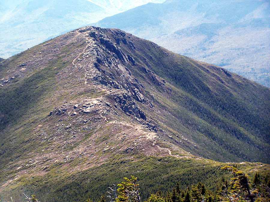
 Bondcliff from West Bond
 Bondcliff Trail
Bondcliff

Garfield, Galehead, South Twin, and North Twin (#37, #38, #39, #40)

Date of Hike: 1/30/11

US 3 / Gale River Road: 1.4 miles
Garfield Trail: 4.8 miles
Garfield Ridge Trail: 3.3 miles
Frost Trail: 1.0 miles
Twinway / North Twin Spur: 4.2 miles
Garfield Ridge: .6 miles
Gale River Trail: 4.0 miles
Gale River Road / US 3: 3.0 miles
Total Miles: 22.3 (6,000 elevation gain)
Click here for trail descriptions

Trip Report:
- After a great week of training I figured Sunday would be a good day for a challenging hike over Garfield, Galehead, South Twin, and North Twin.
- Left Five Corners at 6:15am, Garfield 9am, Galehead 10:45am, South Twin 11:45am, North Twin 12:20pm, Gale River Trailhead 3pm, finished 4:15pm. Temps 5-15 degrees, good views of Pemi Wilderness from Garfield, socked in the rest of the day, breezy on South Twin summit and very cold!
- The Gale River Road is closed in the winter so I started the hike out at 'Five Corners' off US-3 in the dark. I'm not a big fan of road walks but it was a pretty short and quick 1.5 miles over the newly constructed bridges on the Gale River Road to the Garfield trailhead.
- The Garfield Trail was well broken out and the trail ascends gradually with no steep spots.  There are no views along the way but it's a picturesque hike in the snow laden woods.  The only downside to this trail is the semi-annoying switchbacks as the trail gains the ridge.
- Views from Garfield's summit were pretty cool, there was a purplish early morning glow over hovering over the Pemigewasset Wilderness.  I didn't hang around for long because of the frigid temps and what might lay ahead of me on the dreaded Garfield Ridge Trail!
- Going into this hike I had psyched myself up for a trail-breaking sufferfest along the ridge to the Gale River Trail junction. Luckily by some miracle for the first time in weeks there would be no major trail-breaking today!
- The previous day two brave souls (Jeff and Karine) broke trail to the Gale River junction and what's even more impressive is they stayed exactly on trail the entire time which takes some super skills.
- However, the hike to the Galehead Hut was still annoying as ever with numerous PUDS (pointless up and downs), high snow levels, and snow bombs falling from every branch along the way.
- Once past the Gale River Trail junction I was thrilled because the trails would be all broken and packed the rest of the day.
- When I reached the Galehead Hut it was off to the awesomely boring summit of Galehead.  I carefully avoided dead end bushwhacks I made my way to and then up the frost trail where most branches were at face level because of the snow depths. I avoided getting my eyes poked out but got whacked in the face a few times.
- At the summit I put on some dry layers, refueled, and took a picture of the buried summit cairn and got the hell out of there!
- Next was the steep ascent up the Twinway to South Twin, usually I book it to see how fast I can hike the 0.8 miles but today I played it safe and just went at a steady pace all the way up to the breezy low visibility summit of South Twin.  I didn't linger long on the South Twin summit, it was really cold so I hurried over to the North Twin Spur Trail and quickly descended back into the woods and out of the wind.
- I finally ran into the first hiker of the day just before reaching the North Twin summit where of course there were no views.
- The hike back over to South Twin wasn't to exciting but the descent down the Twinway to the hut sure was as it was a slip-slide-speedfest complete with controlled and uncontrolled "white-washes."
- The highlight along the 4.0 miles down the Gale River Trail was the first snowbridge over the Gale River, which If you're zoning out you'd never know your walking over the river.
- Now came the final 3 miles on the Gale River Road back to the car, yes I'm a bit delayed as I could have just headed right instead of left and cut half the mileage off back to Five Corners. I was pretty beat up and cold but it was time to suck it up! I passed a ranger on a snowmobile and got passed by a dozen snowmobilers including a few that pretty much ran me off the road!
- I made it back to the car a little before dark and immediately stuffed thousands of calories of yummy in my face!

Pictures: Click here for all pictures
Mount Lafayette
 Pemigewasset Wilderness
 Owl's Head
 Mount Garfield Summit


Mount Hale, Zealand, South & North Twin Loop

Date of Hike: 9/4/10

North Twin Trail: 1.0 miles
Mount Hale Trail (Fire Warden's Trail): 2.5 miles
Lend-A-Hand Trail: 2.7 miles
Twinway: 6.2 miles
North Twin Spur/North Twin Trail: 5.6 miles
Total Miles: 18.0 miles (5,300 elevation gain)

Trip Report:
- My original plan was to meet up with hikers and take the Caps Ridge up Mount Jefferson and then head over to the Sphinx Trail to do some trail work.  However with high winds forecast for the Presidential Range I figured it would be more enjoyable to find another hike to do and hit the Sphinx on a better day.
- Luckily enough I was invited by Bob and Geri to do the awesome Loop hike over Hale, Zealand, South and North Twin Mountains.  Also joining in on the fun was Mike, Chris, and his girlfriend Christine, since there were three Chris's I was called Chris 3, along with Chris 2, and Ms. Chris!
- On trail at 9am, finished at 5:45pm, Temps in the 60's below treeline, 50's above treeline, light wind, with high clouds and good views.
- Last month while hiking solo I was able to do this hike counter-clockwise because the forecast called for better views early in the day.  This time the forecast was for better views later in the day so the route for the hike was clockwise.
- Our first objective was to find the obscure turn-off for the defunct Fire Warden's Trail, the trick is to locate the strongest little tree on the trail and you'll find the old trail! (click here for picture)
- We made good time up the Mount Hale/Fire Warden's Trail through the beautiful Birch glades.  As we gained elevation fog slowly fell into the trees making for a pretty cool atmosphere.
- At Mount Hale summit we relaxed for a few minutes before heading down the Lend-A-Hand Trail.  While descending the clouds started to lift and the sun started to come out and from here on out we'd be hiking in mostly favorable conditions.
- Once we reached the Twinway we took a break on the rocks above Zealand Falls to refuel and fill up on water before heading up the Twinway to Zealand Mountain.  The views from the outlook into Zealand Notch over to Carrigain Notch were great along the way.
- From Zealand the Twinway drops down into a col then back up to Mount Guyot and over to South Twin. One of my favorite places to hike is the short section above treeline on Mount Guyot looking down into the Pemigewasset Wilderness to Owl's Head with the Franconia Ridge rising high above it.
- We made good time over to South and North Twin and enjoyed the fantastic 360 degree views from South Twin and the terrific views of Galehead and the Garfield and Franconia Ridge from North Twin.
- Now was the long decent back to the river, the first part of the decent was steep but then the grades moderated as we reached the third water crossing.  We decided to use the herd path and bypass the first two crossings as Gerri lead the way setting a good pace as we jogged the remaining mile or so.
- We were all excited to finally be back at the car and having completed such a great hike.  I was also excited to have been able to hike with other people who like to hike at a quick pace and have lots of experience that I can learn from.  Last winter Mike and Bob both completed a single season 48 (Bob twice!), Chris and Christine have completed and are training for a marathon, and throughout this hike Geri was our leader making sure we made good time. Thanks guys fro letting me join in on an awesome hike!!

Pictures: Click here for all pictures

Hiking through the Birch glades
 on the Fire Warden's Trail
View toward Carrigain Notch from the Twinway
Mount Guyot Summit with the
Franconia Ridge off in the Distance 
High Clouds over the Pemigewasset Wilderness
Owl's Head and the Franconia Ridge