
Date of Hike: 1/24/15
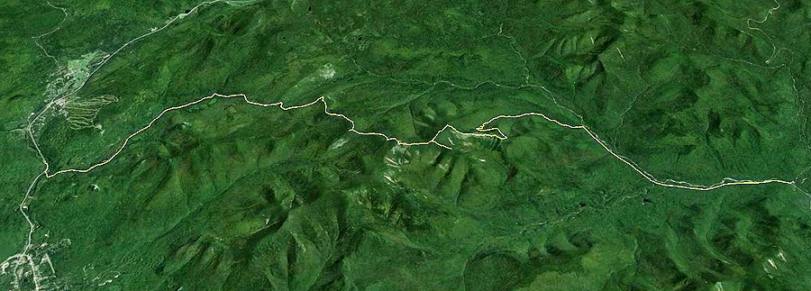
Route 302 & Zealand Road: 4.0 miles / Zealand Trail: 2.5 miles / Twinway: 4.6 miles / Bondcliff Trail: 0.8 miles / West Bond Spur: 1.0 miles / Bondcliff Trail: 7.9 miles / Lincoln Woods Trail: 2.9 miles
Total Miles 24.0 (4,900 feet elevation gain)
Trip Report:
- On Saturday I joined in on a Zealand - Bonds Traverse for Gryffin's 48 - 4,000 footer finish. Gryffin is a Golden Retriever that reminds me of Teddy, he runs up and down the trail wagging his tail with his tongue hanging out as happy as can be. There were three other strong dogs joining in on the hike, Lucy an Australian Shepard, Kibo a Yellow Lab, and Marlie a Terrier Boxer mix. Meanwhile the hikers consisted of Tim, Mark, Jason, Brent (click here for his report and pics), Ian, Matt, Theresa, Holly, Steve, and myself.
- We spotted cars at Lincoln Woods at 5:15 a.m. Believe it or not Lincoln Woods was hopping, as Michael and Monica where leading a group hike of their own over Hale-Zealand-Bonds. We all jumped in and headed north to the Zealand Road winter lot off Route 302 and started hiking around 6:15. The road walk up Zealand Road is the longest of the road walks to bag a 4,000 footer as it is four miles to the start of the Zealand Trail.
- We hiked in our boots up to Zealand Falls Hut and then put on our snowshoes until descending Bondcliff. There were excellent snowshoe conditions above Zeacliff all the way until the highest water crossing of the Black Brook beneath Bondcliff. The group ascended at a good pace as we spread on the ups and stopped at each major junction or summit to regroup.
- Twenty-four miles is a long day for a dog but they all did very well. Temperatures were in the mid to high twenties throughout the day so it was plenty warm enough and the 'balling' of snow on the dogs pads were minimal.
- Even though the hike is twenty-four miles, about eleven of the miles are mostly flat or over easy grades along Zealand Road, the first two miles of the Zealand Trail, and the last five miles along the old Wilderness Trail on the back end (it's now the Lincoln Woods Trail to the Pemi wilderness boundary, and Bondcliff Trail from there). The other thirteen miles has pretty much everything; a steep burst from the hut to Zeacliff, a moderate ascent from Zeacliff to Zealand's summit, then a couple of up and downs over to Guyot, West Bond, Bond, and Bondcliff, followed by a long descent from Bondcliff to the old Railroad grade.
- Between Guyot and Bondcliff are some of the most incredible views in the White Mountains; Owl's Head and the Pemi Wilderness with The Twin Range, Garfield Ridge, and Franconia Ridge rising high above to the west and north. To the south and east is the rugged ridge line of Bondcliff. Way off to the west you can spot the Green Mountains of Vermont, closer to the north is the White capped Presidential Range dwarfing all other mountains.
- We caught the weather just right as we had great views and high clouds until West Bond, then the snow slowly started rolling in on our way to Bond, and snow squalls landed on us as we celebrated Gryffin's finish on Bondcliff, followed by the snow tapering off as we descended Bondcliff. We had a nice enjoyable flat walk out of the Pemi Wilderness as the sun set...Perfectly timed hike with a great group!
Early morning on Zealand Road as we pass by the Hale Brook Trailhead on our way to Zealand Trailhead
The group hikes the bridge as they make there way towards Zealand Pond
Snow is almost burying a footbridge over the Zealand Pond outlet
Making our way to Zealand Falls Hut
Lucy, Gryffin, Brent, and Jason cross over the top of Zealand Falls
The Zeacliff Outlook - Whitewall Mountain, and Zeacliff Pond
Whitewall
Carrigain Notch
The sun trying to shine through a purple haze
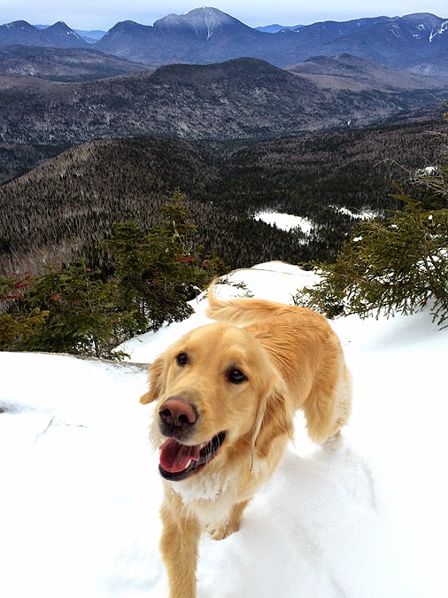
Gryffin!
Heading up to Zealand Mountain
Zealand Mountain summit
Heading to North Guyot
Looking toward Mount Carrigain from North Guyot
Mount Garfield over to Mount Lafayette and Lincoln
Presidential Range as seen from North Guyot
Brent and Jason breaking out of the trees along the Twinway
Lucy getting goofy on Guyot
Gryffin taking in the views
Mark, Marlie, and Ian on North Guyot
Tim and Gryffin with the Presidential Range behind them
Heading to Guyout
The gang hooks onto the Bondcliff Trail over to Mount Guyot
Jason on his way to West Bond
Looking down into the Pemigewasset Wilderness
On the way to West Bond
Gryffin and Lucy on West Bond as Jason makes his way up with Bondcliff in full view from the summit
West Bond sub summit and Mount Garfield
Twinway Slides
Garfield and Franconia Ridge
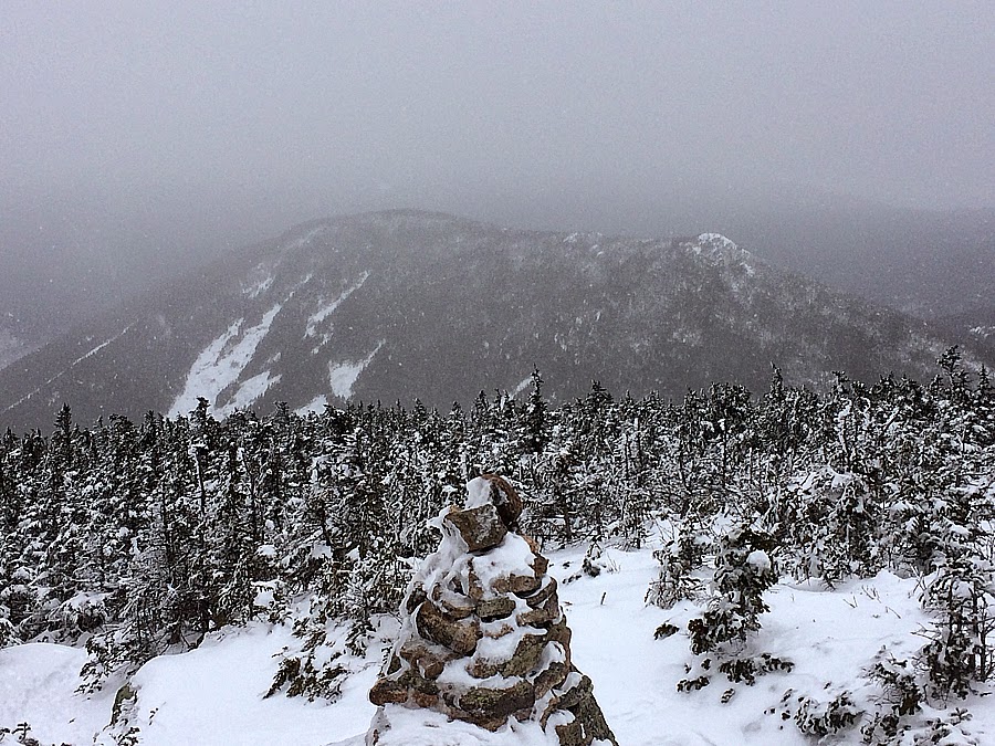
Bondcliff
Heading to Mount Bond
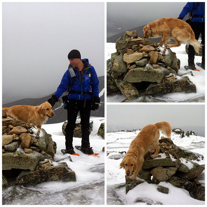
Gryffin on Mount Bond!
Snow moving in over Bondcliff
West Bond from Mount Bond
Dropping down to Bondcliff
Owl's Head with Liberty and Flume behind it
Owl's Head and the Franconia Ridge
Guitar and Monster Slides of West Bond
West Bond from Bondcliff
#48 for Gryffin!
Jason on Bondcliff
Ian and Marlie on Bondcliff
Descending from Bondcliff
Hiking through a snow squall!
Crossing the Black Brook, the Black Brook Trestle from the early 1900's logging Railroad, and the old Bondcliff / Wilderness Trail Junction
Hiking out along the old Railroad grade
Route for the day, click here for details


