Showing posts with label Mount Hale Fire Warden's Trail. Show all posts

A Day Late and a Picture Short . . . Mount Hale Via Fire Warden's Trail

Date of Hike: 10/30/16

North Twin & Herd Path: 1.0 miles  /  Mount Hale Trail: 4.8 miles  /  Herd Path & North Twin Trail: 1.0 miles
Total Miles: 6.8 (2,256 feet elevation gained) Garmin Forerunner 910 XT

Trip Report:
- SNOW came to the White Mountains recently, dropping close to two feet above 6,000 feet on Mount Washington over the past ten days and about a half foot plus around 4,000 feet.  I was hoping to catch snow and ice covered Birch glades along the old Mount Hale Trail (AKA Fire Warden's Trail) but the weather on Saturday turned to rain and warmed up melting away the winter wonderland feeling.  Still, there was about four inches left around 4,000 feet but not much anywhere else.
- Kyle joined me for the hike up the old trail which stopped being maintained in 1957.  However, the abandoned trail is still easy to follow and sees quite a bit of use.  The grade and footing is extremely easy as it follows the old 'tractor' road that the fire warden used to head up to the fire tower on Hale's summit.  There are a few step-over blowdowns here and there but overall the trail is in incredible shape.
- The highlight of the old trail are the Birch glades which are very beautiful, especially during peak foliage and even more so after a fresh snowfall.  Today, it took on a springtime feeling with rotting snow covering the ground.
- The other interesting part of our hike was finding four old telephone poles, a few wire and hooks, and two rails on the North Twin Trail.  The telephone poles ran all the way to the summit tower at one point (I think), the rails were from the Little River Railroad which was in existence between 1893 - 1900.

Just a few feet off the North Twin Trail if you look around you can find a few downed telephone poles and cables and wires 

 Kyle took me to this really unique waterfall about one hundred feet off trail

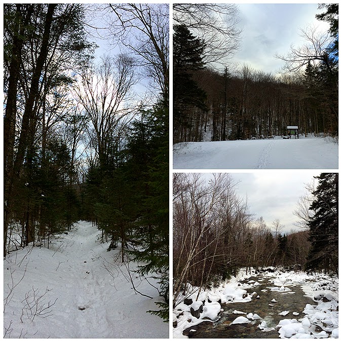
The start of the abandoned Mount Hale Trail.  Notice how easily distinguishable

Around 2,000 feet we finally start to see some snow

Mount Hale Birch glades, a prime spot for back-country skiing! 

Kyle takes a moment to enjoy the view of the glades

Once past the Birch glades the trail heads back into softwoods through a section I refer to as the Pine tree tunnel 

Once gaining the small ridge below a sub-peak of Hale the trail goes through a  section filled with Old Man's Beard

The deepest snow we encountered, 4 inches and melting fast

The always exciting summit of Mount Hale! 

Breaking Out the Birch Glades : Fire Wardens Trail to Mount Hale

Date of Hike: 11/30/14

Herd Path: 1.0 miles  /  North Twin Trail:  1.0 miles  /  Mount Hale (FW) Trail:  4.7  /  North Twin Trail: 1.0 miles  /  Herd Path:  1.0 miles
Total Miles: 8.70 (2,470 feet elevation gained)  GPS Garmin Forerunner 910XT

Trip Report:
- Sunday was a warm day in the mountains which turned the fluffy snow base of the past two days into a heavy and wet base.  I figured I'd hike a lower 4,000 foot mountain so I could leave the snowshoes behind.
- I decided to head to Little River Road and over to Mount Hale via the old Mount Hale Trail, AKA the Firewardens Trail to enjoy the nice gradual ascent through the Birch glades.  When parking at the end of Little River Road, Please do not block the bridge, do not wear spikes on bridge, and respect the the area and the local home owners who let us use their property to access the mountains.
- I started my hike around 11:30 and was surprised there were no other cars to be found and no recent evidence of heavy hiker travel heading along the old logging road on the way to the North Twin trailhead on Haystack Road.
- It's an easy hike to the start of the Fire Wardens Trail, which is located off the herd path that bypasses the first two water crossings along the North Twin Trail. 
- Once I hooked onto the old fire Wardens road I quickly realized that I should have brought my snowshoes as the trail was not broken out and snow depths kept increasing the higher I went.  I wasn't upset because I wanted a workout and not having the snowshoes gave me quite the workout as extra effort had to be made as a major balling up of the snow was happing since the temps were in the 40's.
- The main attraction of the Fire Wardens trail is the huge birch glades it passes through.  After another big snowfall these glades will be a great place to ski and snowboard.  The birch glades transition back to pine as the old trail gains the ridge just north of the summit of Mount Hale.  The Trail passed through trees that were blanketed in 'Old Man's Beard'
- Soon after passing through the Old Man's Beard section the trail drops down and then shoots up to Mount Hale, where the trail ends on the western side of the summit.  I changed into dry layers and ate lunch on the summit, the weather was unseasonably warm for 4,000 feet and above me the clouds were breaking open a little bit which was an added bonus.
- Once done with lunch I took some pictures and high-tailed it out of there and booked it back down the Fire Wardens Trail.  It's one of the easiest descents in the snow of a 4,000 footer, it has an easy grade and is basically like heading down and ramp on a small decline.
- Once back on the North Twin Trail I quickly made my way back to the trailhead and then jumped onto the herd path over the old grade back to the Jeep, but not before stopping at the weird looking fireplace and rock foundation building next to the road, see pic below.

 Route for the day, click here for details
Hiking along the herd path which starts to the left immediately after the bridge
 North Twin trailhead, the lower end of the trail, and the Little River
 The upper right is where the North Twin Trail crosses the Little River for the first time, the herd path that bypasses the first two crossings heads left here, which can be seen on the image on the left
 The beginning of the Fire Wardens Trail can be found at this tree above a small embankment where it takes a left and hooks onto the old tractor road
Mount Hale Trail, AKA Fire Wardens Trail has easy to moderate grades throughout
 Entering the Birch Glades, great place to ski and snowboard when there's a little more snow
The woods transitions back into pine then it gains the ridge just north of Mount Hale's summit where the old trees have an abundance of Old Man's Beard
 Heading up to Mount Hale
  Mount Hale's Summit, there used to be a firetower up here in the World War II era
 Views from the top
Descending back down the Fire Wardens Trail
 Back through the upper section of pine that transitions into birch
 Birch Glades, notice the blue paint on the lower right Birch tree!
Heading back out to the Jeep, along the Little River and herd Path and checking out the old stone fireplace and cellar


Fall, Winter, Spring, and Summer in a Day: Twins - Zealand - Hale Loop

Date of Hike: 5/27/13

North Twin Trail: 4.3 miles  /  North Twin Spur: 1.3 miles  / Twinway: 6.2 miles  /  Lend-a-Hand Trail: 2.7 miles  /
Mount Hale Fire Warden's Trail 2.5 miles  /  North Twin Trail 1.0 miles
Total Miles: 18.0 (5,300 elevation gain)

Trip Report:
- Last year on Memorial Day weekend I was jumping in the East Branch of the Pemi River near Stillwater Junction deep in the Pemigewasset Wilderness.  This year there would be none of that as rain, sleet, and snow came to the White Mountains over Friday, Saturday, and Sunday.  I waited out the storm, enjoyed reading the hikers on two facebook 4,000 footer hiking pages overreact to the weather, and planned my hike for Monday.  I decided a Twins - Zealand - Hale Loop was a perfect hike to play in the mud, water, and snow!
- I arrived at the North Twin trailhead just after 8 a.m., it was already in the low 40's, the sun was out, and the wind was calm.  I was surprised to see six other cars at the trailhead this early but was happy to know there would be other people out there.
- There are three crossings of the Little River before the trail starts to ascend to North Twin.  Usually at this time of year I would do all the water crossings but since they were running high and it was the beginning of the hike I decided to take the herd path bypass and only deal with the final crossing.  However, there was a hiker who was doing all three crossings, good for him!
- When I got to the third crossing I ran into a group of around seven, most of which were taking off their boots and wading across, none of them seemed really thrilled to be doing this.  I just hopped across getting half of my trail runners wet....The hikers probably rolled their eyes when I did this as they stood there freezing their feet off!
- Next the fun began, the trail was a wet muddy mess transforming to snow and running water and then all snow above 3,500 feet.  I took one nasty slip and smashed my left hand on the ground, my left hand which was holding my trusty old camera 'FrankenCamera'.  This time there would be no fixing FrankenCamera as the lens popped out and nothing I did was able to fix it.  So I was now using camera #2.
- I was pretty amazed at the snow on the trail, it was heavy spring snow and the warm temps were melting all the snow off the ferns creating a rain shower in the trail.  I was soaked by the time I got to the outlook just below the summit.  The wind was whipping pretty good, probably around 20-25 mph so I took a few pictures and kept on moving up to the summit and over to the summit outlook.
- There was about three to four inches of snow on the trail but no other tracks so it was pretty fun trudging through the North Twin Spur Trail between North Twin and South Twin.  The rocks and roots were hidden so it was an ankle buster minefield.
- The temperatures were in the 40's but with the wind and the rain shower from the trees I had to keep on moving to stay nice and warm so I didn't linger long on the summit of South Twin. 
- The hike over towards Guyot was more of the same, a little less snow but a couple of blowdowns and some slippery bog bridges under the snow.
- When I popped out into the scrub near the Bondcliff trail junction I was treated to amazing views, unfortunately camera #2 had froze up so now it was onto camera #3, my Apple Phone.
- The wind was still whipping at a decent rate so I couldn't really enjoy the views for too long before heading over to Zealand Mountain.
- The hike down and up to Zealand Mountain was a lot wetter as the snow was started to melt and create puddles under it.  I was soaked and just kept on trucking and not stopping until I made it to the summit.  I took a break at the summit to eat lunch and put on my winter mittens.  Up until this point I had my regular mittens on but they were soaked and my hands were freezing.  I waited for my hands to warm up and took off down towards Zeacliff and then to the Lend-a-Hand Trail Junction.
- I finally ran into the first hikers since the last water crossing of the Little River over six miles ago.  I ended up coming across over a dozen hikers in a short amount of time all heading to Zealand.
- The trail quickly went from snow to mud and standing water.  The lower I dropped the warmer it got and by the time I reached the Lend-a-Hand Trail I was in a short sleeve shirt.
- The Lend-a-Hand Trail started off dry for about the first quarter of a mile but then became wet and muddy with snow up higher.  There was only and inch or two of snow, much less than on the Twinway so it was easier to navigate.
- I made good time up to the summit where there were a few other hikers relaxing and taking in the views...of a pile of rocks, Hale isn't really the most exciting of summits!  I didn't stay long on the summit, maybe ten minutes at most to refuel before I headed down the abandoned Fire Warden's Trail.  The Fire Warden's Trail is a great old trail that sees a lot of use and in my opinion is much more enjoyable than the Hale Brook Trail.  It was very muddy with some boot sucking mud like an Adirondack trail but was a joy to hike down as the Birch glades are beautiful.  I took a fall on my butt and was full of mud but loved every second of it.
- When I hit the North Twin Trail I dipped my muddy feet in the Little River which was cold but refreshing.  I made it back to the car shortly before three and changed out of the muddy mess I had become before heading back home excited that I'll be back in a couple of days with my friend Tom Diaz from our days at 'The College of the Quinnipiac University'!!

Started 8:20 a.m.  /  North Twin Summit 10:10 a.m.  /  South Twin Summit 10:40 a.m.  /  Zealand Summit 11:45 a.m.  /  Hale Summit 1:55 p.m.  /  Finished 2:50 p.m.

North Twin Trailhead
 North Twin Trail
 First Crossing of the Little River
 Hiker making his way across
 If you find this tree bang a left to head up the the Fire Warden's Trail
 Second Crossing of the Little River
 North Twin Trail
 North Twin Trail
 Third Crossing of the Little River
 North Twin Trail
 North Twin Trail
 Approaching the summit of North Twin
 North Twin Trail
 Mount Hale
 Zealand Mountain
 Mount Tom, Field, and Willey
 North twin Trail Outlook
 South Twin
North Twin Summit Area
Mount Hale, Garfield, Lafayette, and Lincoln in some light clouds
North Twin Spur
North Twin Spur 
 North Twin Spur
 North Twin Spur
 North Twin Spur
South Twin 
Mount Washington
 Guyot
 North Twin Spur
 North Twin Spur
 Rime Ice on the South Twin Summit
Twin Range to Guyot 
 Zealand Mountain
 North Twin from South Twin's Summit
 South Twin Summit
 South Twin Summit
 South Twin Summit, Mount Garfield, Lafayette, and Lincoln
 Mount Lafayette and Lincoln
 Franconia Ridge
 South Twin Summit
 Twin Range and Guyot
Mount Guyot, Bond, and Carrigain
Twinway 
 Twinway
Mount Guyot
 Twinway
 Owl's Head and the Franconia Ridge
 Twinway
Pemi Wilderness
 
Twinway
Zealand Mountain Summit 
 Twinway
 Mount Tom with the Presidential Range behind it
 Whitewall Mountain
 Carrigain Notch
 Mount Tom, Field, and Willey
 Mount Hale from the Twinway
Twinway
Rock hop crossing  #2 above Zealand Falls
Rock hop crossing  #1 above Zealand Falls
Lend-a-Hand Trail
 Lend-a-Hand Trail
Lend-a-Hand Trail
Sputnik?
Approaching Mount Hale's Summit
Mount Hale Summit Rock Pile
 Lend-a-Hand Trail
 Fire Warden's Trail
 Fire Warden's Trail
 Fire Warden's Trail
 Fire Warden's Trail
Mud!