
Date of Hike: 5/12/12
Lincoln Woods Trail 1.4 miles
|
Osseo Trail 4.1 miles
|
Franconia Ridge Trail 5.0 miles
|
Garfield Ridge Trail 6.6 miles
|
Twinway 2.8 miles
|
Bondcliff Trail 0.4 miles
|
West Bond Spur 1.0 miles
|
Bondcliff Trail 6.5 miles
|
Lincoln woods / Wilderness Trail 4.7 miles
|
32.5 miles
|
.
|
9,500 elevation gain
|
Trip Report:
- For most recent Pemi Loop, click here
- With almost all the snow gone from the ridges that make up the boundary of the Pemigewasset Wilderness it made Saturday a perfect day for a Pemi Loop.
- The forecast called for sunny skies with increasing clouds and high wind gusts out of the west/north west, temperatures in the 50's above treeline and near 70 in the woods.
- I started hiking at 5am and once again decided to hike it clockwise by heading up the Osseo Trail to the Franconia Ridge. The Osseo Trail is one of the best maintained trail in the White Mountains, it has very moderate grades with one short steep section above the 'downlook' aided by well placed ladder steps to prevent trail erosion. Basically the trail is the equivalent of being on a treadmill with the incline set at 10.
- As I ascended closer to Franconia Ridge I could hear the wind above me and as soon as I reached Flume Mountain's summit the wind hit me pretty good. Luckily Flume and Liberty only have short section not shielded by the wind so it wasn't to bad and by the time I made it to Little Haystack the wind died down a little.
- Hiking above treeline between Little Haystack to Lafayette early in the morning was a blast, I had the whole ridge to myself and the wind which was between 20-30mph felt refreshing until I reached the Garfield Ridge Trail at Mount Lafayette. From here until dropping below treeline the wind was directly in my face and the gusts were higher so I stumbled around a few times but still enjoyed the views.
- The Garfield Ridge Trail is much easier heading north than south and I had no issues at all as I summited Mount Garfield where after thirteen miles of hiking I finally ran into the first two hikers of the day who were relaxing out of the wind in the old fire tower foundation. I took a nice fifteen minute break and chatted about hiking with them and then took off to my next stop Galehead Hut.
- In the two weeks since my last hike along this section of the ridge a lot has changed, other than the first hundred feet below Mount Garfield all the snow and ice is gone and the 'steeps' below the Garfield Ridge Tentsite is in full water fall mode make for a slippery but refreshing descent.
- Every time I hike the whole Garfield Ridge Trail I try and count the 'PUDS' (Pointless up and downs), usually I get to around five or six puds before I want to claw my eyeballs out so I just make up a number, this time I'll say 19, in honor of Josh Beckett because just like a PUD, him being on the Red Sox at this point is, well, pointless, here's to you 'Texas Toughguy'...you suck!
- I started running into more hikers as I approached the hut which is now open on a care-taker basis. At the hut there were a bunch of people enjoying the views and relaxing before heading over to Galehead or the Twins. At the hut I met Brian who was also doing a Pemi Loop as well, he caught sunrise on the Franconia Ridge which must have been a pretty awesome sight, nice meeting you Brian!
- From here I pushed it up the steep Twinway to South Twin's summit, along the way I ran into a father and daughter hiking up the Twinway. The girl who is probably around five or so was having a blast as she was marching up the Twinway full speed ahead!
- On South Twin I went over to my secret spot out of the wind to have my lunch and stare at the Presidential Range rising high above before heading over toward Guyot and the Bonds.
- Now the clockwise Pemi Loop becomes much easier, once the back breaking ascent up to South Twin it's a breeze, if going counter clockwise the second half of the hike involves the steep ascent up to Garfield and the sufferfest up and over the false summits to Lafayette. On the other hand the clockwise direction involves the full force of the Lincoln Woods/Wilderness Trail at the end of the day but we'll get to that later.
- The Twinway had some dying monorail and slippery snow in places but nothing bad enough to give anyone fits. Along the way I started running into dozens of hikers, some day hikers, some over-nighters, all enjoying themselves.
- Once I popped out above treeline and hooked onto the Bondcliff Trail over to Guyot the winds started picking up again but it was warm enough that I was able to stay in short sleeves. One of my favorite sections is heading up to Guyot, views are killer and it's a very remote place. I still think Mount Guyot and Mount Clay for that matter should be official 4,000 footers, it sure seems like they fit within the 200' prominence rule.
- The wind kept getting stronger and stronger and by I made it up to West Bond it almost knocked me over, then as I headed down from Bond to Bondcliff it was blasting 40+ mph at times. I was feeling the full force of the winds that rake across the ridgeline over Bondcliff...It was awesome!
- On the Boncliff summit flats I got out of the wind to take a nice break and enjoy the views one last time before dropping below treeline for the final part of the hike down the Bondcliff Trail to the Lincoln Woods/Wilderness Trail.
- Heading down the Bondcliff Trail my stomach started to feel bad, I had been eating and drinking but being up for this long and hiking I started craving different foods that would have made me feel better, unfortunately all I had was granola bars left so the five slices of pizza and cold beer I wish I had would have to wait!
- The two previous Pemi Loops I did I was mentally fried and started having conversations with imaginary friends while stubbing my toes along the Lincoln Woods/Wilderness Trail. This time I felt extremely strong and breezed through to the trailhead with a smile on my face!
- Back at the car I changed up and stretched for a good twenty minutes before heading into town for a meal and a drink before making my way back to RI after an awesome day filled with views while crushing the Pemi Loop!
- On trail at 5am, Flume 6:50am, Liberty 7:20am, Little Haystack 8:05am, Lincoln, 8:30am, Lafayette 9am, Garfield 10:15am, Galehead Hut 11:40am, South Twin 12:25pm, Guyot 1:30pm, West Bond 1:55pm, Bond 2:25pm, Bondcliff 3pm, Lincoln Woods/Wilderness Trail 4:30pm, Finished 5:45pm
Pictures: Click here for all pictures

Osseo Trail

Osceola and Scar Ridge as seen from Flume Mountain

Little Haystack, Mount Liberty and Flume Mountain

Lonesome Lake and the Kinsman's from Franconia Ridge

Kinsman's and Cannon Mountain

Franconia Ridge

Franconia Ridge as seen from Mount Garfield

Mount Washington as seen from South Twin Mountain

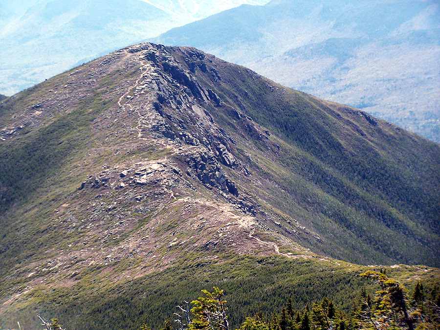
Bondcliff from West Bond
Bondcliff Trail

Bondcliff
Are the pictures of Franconia Ridge from this outing? The reason I ask is that I was up there on Monday and it was pretty much clear of any snow.
ReplyDeleteLove reading your posts.
Jim
Hi Jim
DeleteGlad you like the posts and pics, thanks! Yes all the pictures are from yesterday, there was mixed precip and snow showers last Wed. and Thurs. nights higher up making for some ground cover snow, most of which was melted by mid afternoon. Last weekend when I hiked in the Presi's it was all clear but it was glistening white yesterday in the distance from the Pemi as I hiked.
Wow, awesome pictures! What an outing. A lot is to be said for an early morning start...some really nice lighting from Franconia Ridge. I think most of that snow had melted off by ~2pm.
ReplyDeleteThanks Owen, glad you like the pictures!
DeleteWow! In less than 11 hours? Amazing.
ReplyDeleteDone that POD thing too, a bunch of times. Never remember what number I get. Definitively least interesting part of da Loop.
Alan was up there too yesterday, also clockwise, 1AM start I think. Just to mix things up, back tracked from West Bond over to Zealand and out to Zealand road.
Keep the adventures coming Chris!
11 hours, I wish! It was just under 13, I think I could get down to 11 hours but I may have to run and that would mean missing out on chowing down on my PB&J sandwiches and cookies along the way!
DeleteSounds like Alan had a killer day out there as well, it sure was a perfect day to be out there!
Nicely done - you really kept up the pace! I was wondering about the wind - we were on Cabot (I know, waste of a beautiful day, but lists need to be done!), and while the wind wasn't bad there, we were guessing the wind on anything exposed would be worse.
ReplyDeleteThe wind was fierce at times but fun!
Delete...A hike up Cabot on a nice day still beats staying home and missing out on the mountains!
Holy crap, you were moving. I did 13 miles on Saturday and that took me 8+ hours. But, I was kind of crashing. And, it's funny, I sketched out doing this loop - but, I was thinking about doing a couple of overnights along the way.
ReplyDeleteAnyway, I've been enjoying your posts for a bit. Your brother had sent me the link a bit ago. (I graduated HS with Joe, and I think you graduated with my sister Julie.) Perhaps we'll meet up on the trails one of these days.
Hey Scott,
DeleteSounds like you had a great hike along the Kinsman Ridge, I enjoyed reading your trip report and you took some great pics!
If you do the Pemi as a backpack, hold out for great weather and make sure you stay a night at the Guyot campsite and catch sunset from West Bond, it's an amazing place!
I don't know if Chris Korzen is still trying to put together a Presi Traverse in late June, if so I might join in on that and see you on the trails then.
-Chris
We wondered whether CW is easier or about the same as CCW. See report for 3-day, CCW, Pemi Loop 2 weeks later: http://www.knightway.org/Fred/hiking/PemiLoop2012May26-28/index.html
ReplyDeleteHi Fred, great trip report and pictures, thanks for sending them along. I have done the CCW Pemi Loop in two days and loved it (before I knew people were crazy enough to do it in a day!). I've done the CW one day loop 3X but evenentually I'll do it CCW and see if it's tougher for me that way...I think it will be for me :-x
DeleteHappy Hiking!
Thanks a lot for sharing this experience and the awesome photos too. My gf and I are planning a 3 day / 2 night through the pemi in mid August; are there any decent spot(s)near Mt. Lafayette (other than AMC Greenleaf Hut that requires a 1000 ft. decent) where one could setup tent for the night? The 2nd night, I'd like to stay over at the Guyot campsite. I'd appreciate any feedback, thanks!
ReplyDeleteHi Josh, glad you like the pics and report, thanks!
DeleteAs far as spots near Mt. Lafayette goes, there are no legal spots above treeline up there so you'd have to keep hiking north past the summit of Lafayette on the Garfield Ridge Trail and find a spot once you drop below treeline (1.0 miles), or try finding a spot on the Skookumchuck Trail below treeline(0.8 miles).
You could try to 'stealth' camp above treeline off trail, if a ranger finds you they'll chase you off and tell you to head below treeline and some hikers will give you the evil eye like the world is going to end so take your chances with that.
have a great Pemi Loop!!!
You could try to make it to the Garfield Ridge Campsite on day 1, the lean-to will probably be full but there are tent platforms for $7 a night and a good water source.
DeleteThank you for the reply/tips! Really appreciate it!
DeleteAnother nice report and great pics, Chris. I did the Ammo Trail that day. Got to the Lakes Hut at 4 having started at noon. The winds in the last 1/4 mile were fierce, and due to a misplaced 1/4 mile-to-hut sign and poor marking I lost the trail so bushwacked, postholed and stumbled it to the hut. Per MWObs, the winds were highest for the day at 4, 86 mph gusts, 70 sustained. I'd say it was around 50 sustained with gusts to 70 at the hut. As with the others who'd passed me, descending as I climbed, I opted not to attempt W. Also bailed on Monroe. Just didn't want to fight the winds. Some before me had done Monroe, but no one I saw who went up Ammo did Washington - the three parties which had done it had come from the north, including a couple guys who bailed on an N-S Presi Traverse due to the winds.
ReplyDeleteAfter donning the rain pants and fall jacket, I left the pack at the hut for a bit to go snap some pics southward on the Crawford Path, then made my way back down, this time on the trail - found the mis-placed no camping sign at the 1/4 mile mark by the brook and propped it up in a prominent place.
Anyhow, it was a beautiful day. The views were B+ later in the pm, maybe 50 miles. It was a gorgeous day. I really enjoyed climbing the Ammo, deploying my microspikes in the upper half mile or so, as there was significant snow higher up on its north-facing slope. The waterfalls were many and beautiful.
I got some good pics along the way and have posted them on my Panoramio page - the best of them are on this page: http://www.panoramio.com/user/5078936?comment_page=1&photo_page=8.
Hey Arkie,
Deleteyour hike sounds like one hell of an experience, glad you came out ok and got some good views later in the day. Monroe eventhough it's a short burst is always windy and beats the crap out of you along the way!
Hey Chris- I'm thinking of doing this loop in a couple weeks and was wondering if you know what I should expect weather-wise. I'm going to do it over a couple days- so Summer weight sleeping bag, or hardcore sleeping bag?
ReplyDeleteThanks!
Hey, you should be able to use the summer sleeping bag unless an extreme coldfront comes rushing through (which can happen anytime of the year). I would just monitor the weather leading up to your hike and if overnight temps stay above freezing (which they usually do until mid september) you'll be fine with the summer bag.
DeleteHope this helps and have a great hike!!