
Date of Hike: 7/21/13
Crawford Path 2.9
|
Webster Cliff 0.2
|
Crawford Path 1.2
|
Eisenhower Loop 0.8
|
Crawford Path 1.4
|
Monroe Loop 0.7
|
Crawford Path 1.6
|
Gulfside 1.1
|
Clay Loop 1.2
|
Gulfside 0.7
|
Jefferson Loop 0.7
|
Gulfside 1.6
|
Lowe's Path 0.3
|
Airline 0.6
|
Gulfside 0.4
|
Osgood 1.0
|
Gulfside 0.3
|
Airline 0.6
|
Lowe's Path 0.3
|
Gulfside 1.5
|
| Jefferson Loop 0.7 |
Gulfside 0.7
|
Clay Loop 1.2
|
Gulfside 1.1
|
Crawford Path 1.6
|
Monroe Loop 0.7
|
Crawford Path 1.6
|
Eisenhower Loop 1.2
|
Crawford Path 1.2
|
Webster Cliff 0.2
|
Crawford Path 2.9
|
Total Miles
|
Around 31.5
|
Elevation Gain
|
12,300 feet
|
Trip Report:
- Sunday was my 3rd Annual Double Presidential Range hike. Just like my first year I was hiking solo and that meant on the way back to Pierce from Madison I would re-tag all the summits!
- Left RI at 2:30 a.m. and was on the trail at 6 a.m. with temps in the high 50's and no humidity, a first for July!
- The weather called for clear skies all day but I ended up being fogged in for most of the hike from early morning just north of Lakes of the Clouds until dropping off of Mount Jefferson in the early afternoon.
- Crawford Path has easy grades with decent footing so I was able to make really good time up to treeline. I only saw two other people on my way to the Webster Cliff junction just below Mount Pierce. I made the quick tenth of a mile hike up to the summit just past 7.am. and was greeted with pretty awesome views.
- From Pierce to the Eisenhower Loop the Crawford Path dips in and out of the scrub and up through open ledges. The trail was a little muddy in spots but I did some trail running and made it to the left turn of the Eisenhower Loop Trail and enjoyed the quick ascent up to the summit. Views down towards the Mount Washington Hotel and Brenton Woods are pretty impressive while hiking the first part of the loop.
- When I reached the summit I was greeted with what I call the first 'In your face' view of the Presidential Range. Mount Monroe is directly in front of you with Mount Washington looming large behind it. The descent back to Crawford Path heading north on the Mount Eisenhower Loop Trail is one of the best for views in all of the White Mountains.
- I ran down the Eisenhower Loop and jogged a little of the Crawford Path as it easily ascends and crests an open field just before the Mount Franklin summit. This small hump is my favorite part of the southern presidential range, I refer to it as the 'Franklin Flats' and the trail is outlined with small rocks the whole way and the views stretch as far as the eye can see.
- Once past the flats I took a right on a small beaten herd path to Mount Franklin's tiny but nice summit and hooked back on the Crawford Path and jogged to the Mount Monroe Loop Trail. It was at this time that I noticed the forecast might be off not just a little but a lot. The clouds and what looked like fog was started to come in from the west. Luckily it wasn't humid so I didn't have to worry about thunderstorms, and cloud cover is a good thing when doing a long hike like this anyway.
- I hit Mount Monroe around 8:30 in the morning and up until this point I had only seen a handful of hikers, but from here on out there would be hundreds along the way!
- There was lots of activity at Lakes of the Clouds Hut, I went inside hoping to score some free pancakes but there must have been a lot of fatties staying there because there were none! I took a short break and then headed up to the rock pile. After about a half a mile the fog and clouds rolled in taking away the views, I wasn't bummed because I figured on my return the views would open back up!
- The hike up to Washington went well, the trail is like a sidewalk as it makes its way up to the summit. I enjoyed this section because I knew from Mount Washington to Madison and back to this point the footing would turn from the nice gravel, slab, and meticulously placed rocks to jagged, loose, odd shaped, knee hammering boulders.
- When I hit the summit I went inside and bought a soggy sandwich, a Gatorade, and a cookie/cookie...for $10, highway robbery! The Sandwich tasted awful but I craved the taste of something different than the gels, gummies, brownie bites, and granola bars I had been eating up until this point.
- After a fifteen minute break on Washington I headed off to the Northern Presidential Range. I have lost count as to how many times I have been through the Gulfside Trail and the loop trails over the summits through this section. I remember how my body used to take a beating up here but through the years but with my La Sportiva Raptors I have adapted and now can rock hop most of it. I think I also may have been blessed with strong ankles, it's just luck that they over all the miles I have never rolled into even a minor sprain.
- The theme of the hike north through Mount Adams was down and up over the boulder fields in the fog, every so often I'd see the sun and a break in the clouds only for it to be gobbled back up in a second and back to viewless. along the way I ran into tons of hikers going in every direction. Unless someone asks me I never tell anyone what I am doing, I usually just say hi and say how great the day is and listen to other people tell me of where they are going and I enjoy hearing about other hikers adventures. There were lots of Presi Traverses out and about, I even ran into one guy doing a double as well!
- Finally the views opened up dropping down from Mount Adams and they stayed that way until coming back up to Mount Adams. Heading up Mount Madison I ran into Peter who was descending on his way to Adams, Madison was his 47th peak and Adams would be his 48-4,000. Congratulations on finishing your 4,000 footers and great to meet you!
- I took a nice little break on Madison's summit and watched the clouds roll back in over Mount Madison. I realized once again, I have a long way back to my car! The good news is I had all day, I made really good time to Madison's summit, making it there in around 6 hours and fifteen minutes.
- I rock hopped back to the hut but this would be the last time I would trail run until descending Mount Washington. I kind of hit a wall here and there throughout my hike back over Adams, Jefferson, and until Clay's summit. Along the way I ran into a few hikers who recognized me from this blog which is always nice. It was nice to meet all of you and hike briefly with s few of the groups along the way. One of the hikers I ran into recognized me from my bumble bee sneakers and was doing an impressive Six Husbands to Jefferson and back to his car at Pinkham Notch Loop via the Glen Boulder Trail.
- Finally when I hit Mount Clay the views opened up and I felt much better, when you have views it's easy to break through walls. On Mount Clay's summit I ran into a hiker with his cute little dog that tried to steal my snacks out of my pack.
- Feeling rejuvenated I rock hopped off Clay and hiked fast back up Mount Washington taking some great pics of the cog as it chugged past me.
- At the summit I needed to fulfill another weird craving, I had a hot dog and skim milk. Yup, how gross is that! But it hit the spot and after a short break I ran down to the Lakes of the Clouds hut in about 25 minutes!
- From here the footing changed back to dirt, gravel, and well placed rocks. My body was holding up well and I ran the downs and hiked the ups. I enjoyed the big views along the way, turning back around every few minutes to watch the big fluffy clouds pass over the range to the north. It's an absolute blast hiking / running through here.
- I ran into a big group on Eisenhower that I saw earlier in the day, they were having a blast enjoying their Presi Traverse. I also bumped into fellow North Providence resident Brandon. Him and his friend were doing the traverse as well. It was nice to see you guys.
- Now was the home stretch, the run and hike to Pierce flew by. I took a break on Mount Pierce's summit to take what I just did all in and admire the views one last time before dropping back under treeline after spending the past 25 miles above it.
- The hike back to the car went well, I just hiked out and other than a couple of hikers it was a quiet descent back to the car. I made it back to the Highland Center just before 6:30 p.m., twelve and a half hours after I started. I just sat in the back of the Jeep for a bit with my feet hanging out before I changed into clean clothes and headed back to RI, making it back home at 10:30 p.m., where I took a shower and passed out from exhaustion dreaming about the next big hike!
Start: 5:58 a.m. / Pierce: 7:04 a.m. / Eisenhower: 7:41 a.m. / Franklin: 8:12 a.m. / Monroe: 8:34 a.m. / Washington: 9:22 a.m. / Clay: 10:05 a.m. / Jefferson: 10:43 a.m. / Adams: 11:35 a.m. / Madison: 12:17 p.m. / Adams: 1:05 p.m. / Jefferson: 2:00 p.m. / Clay: 2:39 p.m. / Washington: 3:20 p.m. / Monroe: 4:09 p.m. / Franklin: 4:30 p.m. / Eisenhower: 5:02 p.m. / Pierce: 5:30 p.m. / Finished: 6:25 p.m.
Start: 5:58 a.m. / Pierce: 7:04 a.m. / Eisenhower: 7:41 a.m. / Franklin: 8:12 a.m. / Monroe: 8:34 a.m. / Washington: 9:22 a.m. / Clay: 10:05 a.m. / Jefferson: 10:43 a.m. / Adams: 11:35 a.m. / Madison: 12:17 p.m. / Adams: 1:05 p.m. / Jefferson: 2:00 p.m. / Clay: 2:39 p.m. / Washington: 3:20 p.m. / Monroe: 4:09 p.m. / Franklin: 4:30 p.m. / Eisenhower: 5:02 p.m. / Pierce: 5:30 p.m. / Finished: 6:25 p.m.

Highland Center Parking Lot

Crawford Path Southern Terminus

Early morning on the Crawford Path approaching treeline

Crawford Path

Mount Pierce Summit

Webster Cliff Trail with Mount Eisenhower in view

Some well placed bog bridges along the Crawford Path just north of Mount Pierce

A section that may need bog bridges! Crawford Path in the Pierce / Eisenhower col

Crawford Path heading north toward Mount Eisenhower

A beautiful morning above treeline on the Crawford Path near the Mount Eisenhower Loop Junction

Mount Pierce to the south
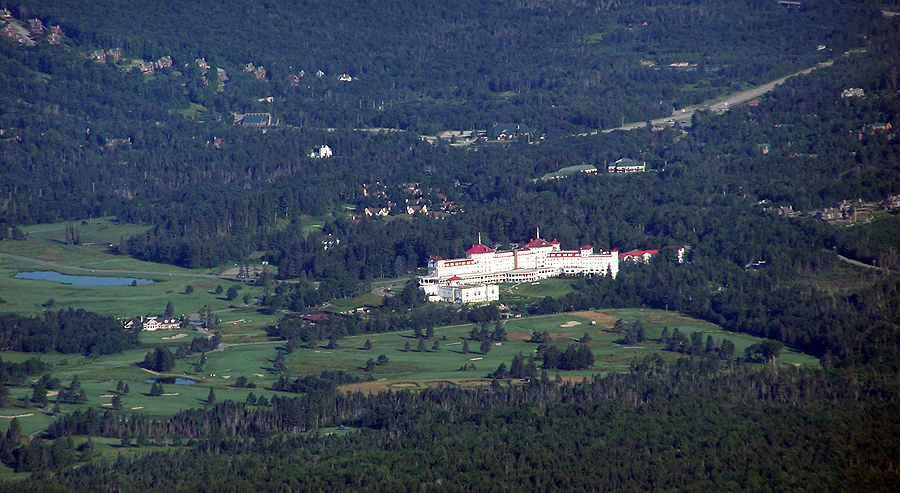
Mount Washington Hotel

Crawford / Eisenhower Loop Junction

Pierce / Eisenhower Col from the Eisenhower Loop Trail

Eisenhower Loop Trail

Mount Pierce summit with Mount Willey rising above across Crawford Notch

Eisenhower Loop Trail

Approaching Mount Eisenhower's Summit

Mount Eisenhower Summit Cairn

Eisenhower Loop Trail

Looking north towards Mount Franklin, Monroe, and Washington

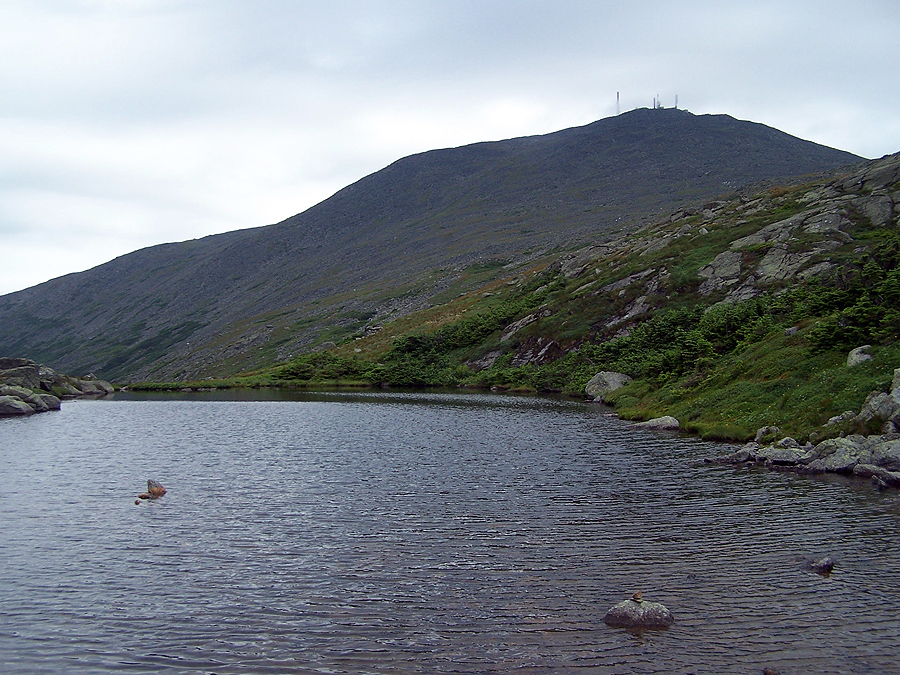
Red Pond at the bottom of the summit cone of Mount Eisenhower

Edmands / Crawford Path Trail Junction

Crawford Path / Eisenhower Trail Junction

Mount Pierce

Crawford Path

Crawford Path just below the 'Franklin Flats'

'Franklin Flats'

Heading north towards Mount Franklin

North on the Crawford Path

Mount Monroe and Mount Washington

Mount Washington

Mount Clay and Jefferson from the Crawford Path

Great section of trail (Crawford Path)

Heading to Mount Franklin

Mount Franklin's Summit

Mount Franklin Spur Path

Looking back towards the 'Franklin Flats'

Southern Presidential Range

Crawford Path just below Mount Monroe

Lil' Monroe

Monroe Loop Trail

Cross Cairn just below the summit of Mount Monroe

Mount Franklin, Eisenhower, and Pierce

Lakes of the Clouds and Mount Washington

Lakes of the Clouds Hut

Lakes of the Clouds

Hikers descending Mount Monroe's Loop Trail

Lakes of the Clouds sitting high above the Ammonoosuc Ravine

Lakes of the Clouds Hut

Weather Warning Sign

The A.M.C. is doing a scientific research on weather
Lakes of the Clouds and mount Washington

Lakes of the Clouds

The old fashioned 'Coal Cog' crawling up Jacob's Ladder

Mount Washington being overtaken by fog

Mount Monroe

Crawford Path and Mount Monroe

Crawford Path, notice how the trail has been built with specific boulders to create a 'sidewalk' effect

Crawford Path, looking south. The fog rolled in and Lakes of the Clouds and Mount Monroe has disappeared

Approaching the summit of Mount Washington

Nature...at its best!

The Cog

Carwford Path northern terminus and Mount Washington's Summit

Observation Tower

The Great Gulf Wilderness being overtaken by clouds

Mount Clay Loop Trail, notice how the trail is now uneven with odd sized boulders

Mount Clay Loop Trail

The Lil' Clay / Big Clay col

Mount Clay's Summit

Looking down off Mount Clay to the Gulfside / Clay Loop Trail Junction

Gulfside Trail heading north approaching the Sphinx Col

Sphinx Col

Gulfside Trail

Heading north to Mount Jefferson

Gulfside / Cornice Trail Junction

Monticello Lawn

Monticello Lawn

Monticello Lawn

Jefferson Loop Trail

Mount Jefferson Summit

Hikers planning their next move at the big cairn on Mount Jefferson

Jefferson Loop Trail

Dogs on Jefferson!

Dropping down to Edmands Col

Popping out of the Edmands Col to the 'Adams Family' range

Gulfside Trail

White A.T. blaze on the Gulfside Trail

Heading to Mount Adams

Thunderstorm Junction in some smoky fog

Looking back down to Thunderstorm Junction

Approaching Mount Adams's summit

Mount Adams Summit

Looking down to J.Q. Adams, Star Lake, and Mount Madison

Durand Ridge, where the Airline Trail travels up

Madison Springs Hut and Mount Madison

Madison Springs Hut

Madison Springs Hut and Mount Madison

Dogs on Madison!

Star Lake and Mount Adams

Star Lake

Approaching Mount Madison Summit

Pinkham Notch, Wildcat Ridge in view

Osgood Ridge

Mount Adams being overtaken by clouds

Osgood Trail with J.Q. Adams in view

Madison Springs Hut and J.Q. Adams

Madison Springs Hut and Mount Adams

Gulfside Trail

Airline Trail up to Mount Adams

Mount Adams Summit

Lowe's Path

Israel Ridge / Lowe's Path Trail Junction

Thunderstorm Junction

Gulfside Trail heading south along the many sub peaks of Mount Adams

Approaching Edmands Col

Edmands Col Cutoff / Gulfside / Randolph Path Trail Junction

Looking down into the Great Gulf

Mount Jefferson Summit

Monticello Lawn

Monticello Lawn

Heading north to Mount Clay

Mount Clay Loop Trail

Hiking along the Mount Clay Loop Trail

Mount Adams and Mount Madison in the clear

Mount Clay Summit

The Great Gulf Headwall

Great Gulf Trail (river / waterfall section)

Great Gulf Irene Slide

Lil' Clay / Big Clay Col

Southern Presidential Range from Mount Clay

Lakes of the Clouds and Mount Monroe

Lakes of the Clouds and Mount Monroe

The cog chugging its way up the tracks

Northern Presidential Range from the Gulfside Trail

The cog

Cog Train, look at the conductor, he seems happy so I passed on mooning him!

The Cog

Another Cog train, this one was empty

The Cog Train

The Cog Railway

Hikers on the Gulfside Trail with Mount Adams rising high above

Gulfside Trail approaching the summit of Mount Washington

Gulfside Trail

Mount Washington's Summit

Inside the observatory

Crawford Path Northern Terminus

Tip Top House

Southern Presidential Range

Lakes of the Clouds and Mount Monroe

Hut Crew bring the goods down to the hut

Crawford Path

Lakes of the Clouds and Mount Monroe

Lakes of the Clouds and Mount Monroe

Crawford Path

Mount Washington's Summit Cone

Crawford Path

Another crew hauling a lot of stuff down to the hut

Mount Monroe

Crawford Path

Lakes of the Clouds

Lakes of the Clouds and Mount Washington

Monroe Loop Trail

Lakes of the Clouds and Mount Washington

Approaching Mount Monroe's Summit

Mount Washington

Descending from Mount Monroe along the Monroe Loop Trail

Looking down to Crawford Path

Crawford Path with 'The Camel's Hump' above

Mount Washington

Heading south along the Presidential Range

Monroe Loop Trail

Lil' Monroe

Mount Monroe and Washington

Crawford Path

Crawford Path

Crawford Path looking back north

Mount Monroe and Washington

Mount Eisenhower

Looking down at a series of paths from the Eisenhower Loop Trail

Looking north at the Crawford Path

Northern Presidential Range

Eisenhower Loop Path

Eisenhower Loop Path

View to the east from Mount Eisenhower

Mount Monroe, Washington, Clay, and Jefferson

Mount Pierce

Eisenhower Loop Trail

Crawford Path

Mount Pierce Summit

Summit of Mount Pierce

Webster Cliff Trail and the Presidential Range

Mount Eisenhower, Monroe, and Washington

Crawford Path

Above Gibbs Falls on the Crawford Path

Crawford Path Southern Terminus

Highland Center and Route 302

Wooden steps at the beginning of the Crawford Path

Highland Center
After over a year of reading your trail reports it was great to finally run into you out on the trail. Awesome job as usual with the pics/report of your double traverse - to see you did it all in under 13 hours is insane. Keep up the great work your blog is the best resource on the web for photos and trail descriptions of so many different hikes in the Whites.
ReplyDeleteHey Brandon!
DeleteGreat to run into you, thanks for introducing yourself and thanks for the kind words about the blog, I'm glad it helps out. Hope you guys had a great rest of your hike!
I'll see you guys on the trail
-Chris
Hi Chris -
ReplyDeleteThanks for the mention, glad I was able to run in to you especially on my 48 finish day. Your blog has been such a valuable resource and a big help in getting me to that point. Thanks again, I look forward to seeing you again, the winter 48 is calling..
BTW, congrats on the double presi traverse - just mind boggling!!
Cheers,
Peter
Great to see you out there Peter, Congrats on your finish!!!
DeleteI saw you twice - both times around Mt Clay (I was a random guy holding a camera like a loaf of bread) - and was wondering if you were up to something crazy like a double traverse. No surprise that you were! I merely did a double traverse of Madison through Washington with a visit to Lion Head thrown in. I can't imagine adding the southern peaks to that.
ReplyDeleteAlways enjoy your blog posts :)
Hi Eric!
DeleteYou got in a killer hike yourself, it was a pretty cool day for it with the weather changing from clear, to fog, then back to clear skies! I'll keep an eye out for you on the trails.
Glad you like the blog, thanks!
-Chris
Hi Chris,
ReplyDeleteCongrats on the amazing hike! It looks like you had a great time out there. I am contemplating taking a similar route in August, maybe starting at the northern end instead though. Your report has really helped to put things in perspective. I am an ultrarunner and a few friends and I may run the route on August 23rd if the weather is cooperating, we have a plan B of running the Wildcats through Moriah traverse as an out and back. Great reports on your blog. Did you hike last year at the MMD (in Evans Notch)? That was my first year running it.
Jesse
Hi Jesse,
DeleteGlad you enjoyed the report. Hope you guys get some good weather for your double run in the Presi's. Starting and finishing at the north end is bad ass! Did not to MMD last year (had a wedding to go to) and haven't been contacted about it this year so looks like I'll miss out on it. Have a great time if you do it again!
- Chris
Thanks, I'm skipping it this year to do this run instead.
Delete