Date of Hikes: February 6,7, & 10, 2016
Zealand Road: 2.8 miles / Hale Brook Trail: 2.1 miles / Lend-A-Hand Trail: 2.6 miles / Twinway: 5.6 miles / Zealand Trail: 2.5 miles / Zealand Road: 3.8 miles
Total Miles: 19.5 miles (4,459 feet elevation gained) Garmin Forerunner 910XT for all hikes
Greeley Pond Trail: 1.2 miles / Mount Osceola Trail: 5.0 miles / Greeley Ponds Trail: 1.2 miles / Hancock Notch Trail: 1.7 miles / Cedar Brook Trail: 0.6 miles / Hancock Loop Trail: 4.2 miles / Cedar Brook Trail: 0.6 miles / Hancock Notch Trail: 1.7 miles
Total Miles: 16.6 miles (5,909 feet elevation gained)
Gale River Loop Road: 1.1 miles / Garfield Trail: 4.8 miles / Garfield Ridge Trail: 0.4 miles / Garfied Trail: 4.8 miles / Gale River Loop Road: 1.1 miles
Total Miles: 12.1 (3,178 feet elevation gained)
Trip Report:
- On Saturday I headed to Zealand Road to hike Mount Hale and Zealand, which when doing both in winter starting and ending at the winter lot off Route 302 is known for the longest road walk in the White Mountains, three miles in and four miles out along Zealand Road. Two of my most exhausting winter hikes have been over this route in previous winters where I had to break several miles of trail along the way. Luckily, on Saturday I had easy conditions with fluffy snow over a hard packed surface making for a quick hike in and out.
- It had been a few winters since hiking the Hale Brook Trail as I have been using the old Mount Hale Trail (AKA Fire Warden's Trail) because of the beautiful birch glades making for a more picturesque hike. The Hale Brook Trail has nothing too exciting along its route, however it's only two miles long so it gets you to the summit relatively quickly.
- The summit of Mount Hale has a big cairn on it where an old fire tower used to stand. If you venture off into the woods near the summit you can find some old relics from the tower, most of which is beneath the snow this time of year but it's fun to explore in the summer and fall.
- From the summit I quickly dropped down the Lend-A-Hand Trail over it's gentle grades and nicely blazed path. I came across the first two hikers of the day about half way down as they were heading up, they like me were happy to be hiking in very tame conditions.
- The Lend-A-Hand Trail ends at the junction with the Twinway right above the Zealand Falls Hut. At the junction I banged a right and headed up the relatively steep Twinway to Zeacliff and caught some unexpected good views over to Carrigain Notch. I was expecting to be in the clouds all day but it was turning out to be a decent day for views.
- After Zeacliff I made my way to the summit of Zealand, the Twinway between Zeacliff and Zealand Mountain's summit has moderate grades with just one short steep burst up some ledges which is aided by a cool ladder step resting against a boulder.
- From the summit I turned back around and had a quick descent back down past Zeacliff, the hut, and out to the top of Zealand Road, where I started the four mile walk back to the car. The temperature was hovering around freezing with no wind which made for a pleasant walk back to the Jeep. For the day I saw six hikers while on the trails and saw several hikers walking up the road heading to Zealand Falls Hut to spend the night.
- Unlike my previous two suffer-fests doing this route in winter where I started at dawn and finished in the dark, I was back to my car before 2PM!
- On Sunday I met up with Kyle at the Greeley Ponds trailhead to do a double hit and run of the Osceolas followed by the Hancocks. The two trailheads are located less than half a mile from each other, and the ranges, which are similar as they both have moderate approaches followed by super steep ascents, are only separated by a couple of miles as well but the conditions couldn't have been anymore different.
- The trail below East Peak of Mount Osceola was covered in sketchy ice under a dusting of snow, Kyle's hillsounds held up well while I had to use extreme caution with my old worn down microspikes. Between the peaks the conditions were better, except for the Chimney which had an evil looking ice flow in it, even the bypass was sketchy, so I used the bypass of the bypass to the Chimney.
- I had my crampons in my pack but didn't put them on, I used the hike to work on my tree-hugging skills to safely descend the treacherous spots on the way out.
- The weather which was supposed to be crummy once again turned out better than expected for as we had decent views from the summit area ledge on the main peak of Mount Osceola.
- Even with the icy conditions we still made good time back to the trailhead just after 10AM, where we changed and refueled before heading up to the hairpin turn where we started hike number two of the day along the Hancock Notch Trail.
- Unlike the Osceola's the conditions on the steep parts of the Hancock's were much better, there was almost no ice just hard packed snow, not enough to butt slide down but more than enough to hide roots, rocks, and any ice. On the way in we ran into Ian and his dog Marley, followed by Hiker Ed.
- Kyle pushed the pace for the whole hike, which I was very happy he did, if I was solo I probably would have taken it easy after yesterday. It was nice to be pushed, even if I felt like and old lion trying to keep up with a young cub at times! Still, on the way out I felt strong as we sprinted back to the trailhead from the summit of North Hancock.
- For the second day in a row my hiking day was finished relatively early, not too shabby!
- With an arctic blast heading into New England over the weekend, Whitney and I decided to get in a nice weather hike on Wednesday up one of the more tamer winter 4,000 footers, Mount Garfield. With it's short road walk, very forgiving and gentle grades all the way up until the last tenth of a mile, we happily hiked our way over the old fire wardens road that is the Garfield Trail.
- We only saw one other hiker during the day, a nice guy from Vermont who is working on his winter 4,000 footers.
- There was a nice fluffy two to four inches of snow over the hard packed older snow making for a pretty hike up as we gained elevation.
- The weather was really nice for our hike, in the high twenties, no wind, the sun was out at times below 3,750 feet, and even though we didn't get any views from the top the summit was very calm and we could enjoy it which for both of us in the winter was a first.






Zealand Road: 2.8 miles / Hale Brook Trail: 2.1 miles / Lend-A-Hand Trail: 2.6 miles / Twinway: 5.6 miles / Zealand Trail: 2.5 miles / Zealand Road: 3.8 miles
Total Miles: 19.5 miles (4,459 feet elevation gained) Garmin Forerunner 910XT for all hikes
Greeley Pond Trail: 1.2 miles / Mount Osceola Trail: 5.0 miles / Greeley Ponds Trail: 1.2 miles / Hancock Notch Trail: 1.7 miles / Cedar Brook Trail: 0.6 miles / Hancock Loop Trail: 4.2 miles / Cedar Brook Trail: 0.6 miles / Hancock Notch Trail: 1.7 miles
Total Miles: 16.6 miles (5,909 feet elevation gained)
Gale River Loop Road: 1.1 miles / Garfield Trail: 4.8 miles / Garfield Ridge Trail: 0.4 miles / Garfied Trail: 4.8 miles / Gale River Loop Road: 1.1 miles
Total Miles: 12.1 (3,178 feet elevation gained)
Trip Report:
- On Saturday I headed to Zealand Road to hike Mount Hale and Zealand, which when doing both in winter starting and ending at the winter lot off Route 302 is known for the longest road walk in the White Mountains, three miles in and four miles out along Zealand Road. Two of my most exhausting winter hikes have been over this route in previous winters where I had to break several miles of trail along the way. Luckily, on Saturday I had easy conditions with fluffy snow over a hard packed surface making for a quick hike in and out.
- It had been a few winters since hiking the Hale Brook Trail as I have been using the old Mount Hale Trail (AKA Fire Warden's Trail) because of the beautiful birch glades making for a more picturesque hike. The Hale Brook Trail has nothing too exciting along its route, however it's only two miles long so it gets you to the summit relatively quickly.
- The summit of Mount Hale has a big cairn on it where an old fire tower used to stand. If you venture off into the woods near the summit you can find some old relics from the tower, most of which is beneath the snow this time of year but it's fun to explore in the summer and fall.
- From the summit I quickly dropped down the Lend-A-Hand Trail over it's gentle grades and nicely blazed path. I came across the first two hikers of the day about half way down as they were heading up, they like me were happy to be hiking in very tame conditions.
- The Lend-A-Hand Trail ends at the junction with the Twinway right above the Zealand Falls Hut. At the junction I banged a right and headed up the relatively steep Twinway to Zeacliff and caught some unexpected good views over to Carrigain Notch. I was expecting to be in the clouds all day but it was turning out to be a decent day for views.
- After Zeacliff I made my way to the summit of Zealand, the Twinway between Zeacliff and Zealand Mountain's summit has moderate grades with just one short steep burst up some ledges which is aided by a cool ladder step resting against a boulder.
- From the summit I turned back around and had a quick descent back down past Zeacliff, the hut, and out to the top of Zealand Road, where I started the four mile walk back to the car. The temperature was hovering around freezing with no wind which made for a pleasant walk back to the Jeep. For the day I saw six hikers while on the trails and saw several hikers walking up the road heading to Zealand Falls Hut to spend the night.
- Unlike my previous two suffer-fests doing this route in winter where I started at dawn and finished in the dark, I was back to my car before 2PM!
- On Sunday I met up with Kyle at the Greeley Ponds trailhead to do a double hit and run of the Osceolas followed by the Hancocks. The two trailheads are located less than half a mile from each other, and the ranges, which are similar as they both have moderate approaches followed by super steep ascents, are only separated by a couple of miles as well but the conditions couldn't have been anymore different.
- The trail below East Peak of Mount Osceola was covered in sketchy ice under a dusting of snow, Kyle's hillsounds held up well while I had to use extreme caution with my old worn down microspikes. Between the peaks the conditions were better, except for the Chimney which had an evil looking ice flow in it, even the bypass was sketchy, so I used the bypass of the bypass to the Chimney.
- I had my crampons in my pack but didn't put them on, I used the hike to work on my tree-hugging skills to safely descend the treacherous spots on the way out.
- The weather which was supposed to be crummy once again turned out better than expected for as we had decent views from the summit area ledge on the main peak of Mount Osceola.
- Even with the icy conditions we still made good time back to the trailhead just after 10AM, where we changed and refueled before heading up to the hairpin turn where we started hike number two of the day along the Hancock Notch Trail.
- Unlike the Osceola's the conditions on the steep parts of the Hancock's were much better, there was almost no ice just hard packed snow, not enough to butt slide down but more than enough to hide roots, rocks, and any ice. On the way in we ran into Ian and his dog Marley, followed by Hiker Ed.
- Kyle pushed the pace for the whole hike, which I was very happy he did, if I was solo I probably would have taken it easy after yesterday. It was nice to be pushed, even if I felt like and old lion trying to keep up with a young cub at times! Still, on the way out I felt strong as we sprinted back to the trailhead from the summit of North Hancock.
- For the second day in a row my hiking day was finished relatively early, not too shabby!
- With an arctic blast heading into New England over the weekend, Whitney and I decided to get in a nice weather hike on Wednesday up one of the more tamer winter 4,000 footers, Mount Garfield. With it's short road walk, very forgiving and gentle grades all the way up until the last tenth of a mile, we happily hiked our way over the old fire wardens road that is the Garfield Trail.
- We only saw one other hiker during the day, a nice guy from Vermont who is working on his winter 4,000 footers.
- There was a nice fluffy two to four inches of snow over the hard packed older snow making for a pretty hike up as we gained elevation.
- The weather was really nice for our hike, in the high twenties, no wind, the sun was out at times below 3,750 feet, and even though we didn't get any views from the top the summit was very calm and we could enjoy it which for both of us in the winter was a first.
To show how the snow levels are at a historical low in the mountains this year, here are two pictures along the Lend-A-Hand Trail. Top is from December of 2010, bottom is from this February!
The winter parking for Zealand Road is about a tenth of a mile east across Route 302. It's a short road walk followed by a long walk up Zealand Road
The Hale Brook Trail. It has moderate grades the whole way, the only problem area is a side hill that can be annoying when buried in snow (upper right)
Turning out to be a nice day as I make it to Mount Hale's summit
Views from the rock pile where the fire tower once stood
Just below the summit cone there is old fire wardens junk off in the woods
The Lend-A-Hand Trail, starts off dropping down through narrow pine and ends up heading through an open Birch glade at the bottom
Whitewall Mountain and the Willey Range (Tom, Field, Willey) from Zeacliff
Whitewall Slide
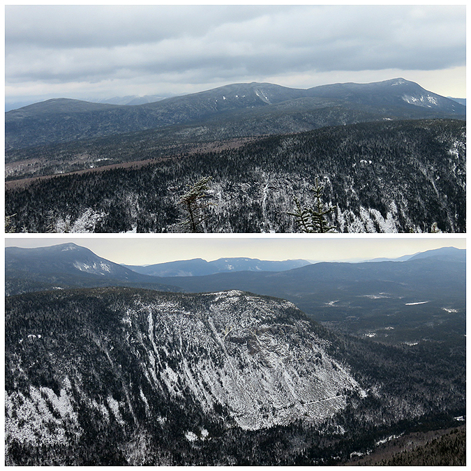
Mount Anderson, Lowell, Vose Spur, and Carrigain (Top). Hancock range (Bottom)
Carrigain Notch
Twinway on the way to Zealand Mountain
Twinway, usually this is buried in snow and at times can be tricky to follow for a few turns
Zealand Falls Hut
Water pump next to the hut
boardwalk along a swampy section of the Zealand Trail
Zealand Road
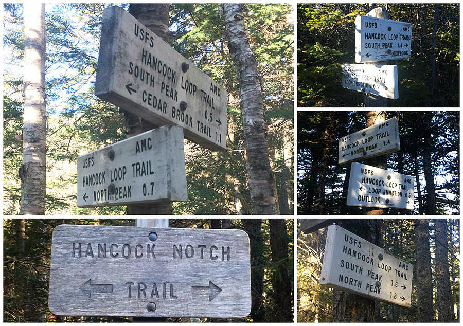
Signs spotted along Zealand Road and up and down Mount Hale
Signs Spotted up to Zealand Mountain and back out
Early morning from just below East Osceola
Mount Osceola
Looking out to the Hancock Range, The hairpin turn is at the bottom of this photo although the turn itself is not pictured
The Chimney, I took the bypass of the bypass to this!
East Osceola
Summit area of Mount Osceola
Signs spotted along the hike over the Osceola's
Heading up Gale River Loop Road
Garfield Trail, it's a nice gentle climb up an old fire warden road
Mount Garfield summit
Heading down from the summit of Mount Garfield
 Hale & Zealand Hike, click here for details


Osceola's and Hancock's hike, click here for details
Mount Garfield hike, click here for details