Date of Hike: 4/17/16
NH 16: 0.5 miles / Camp Dodge Cutoff: 0.3 miles / Imp Trail: 2.0 miles / Carter Moriah Trail: 5.2 miles / Wildcat Ridge Trail: 2.6 miles / Polecat Ski Trail: 2.4 miles
Total Miles: 14.0 miles (5,969 feet elevation gained) Garmin Forerunner 910XT
Trip Report
- Sunday's weather rose well over 50 degrees above 4,000 feet with plenty of sunshine. The continued warm up made the ice rink trails a little easier to contend with, although I still had to step off trail a few spots to down-climb monkey style!
- I parked my car at Nineteen-Mile Brook trailhead and road walked up Route 16 and cut through Camp Dodge on my way to the Imp Trail, which was mostly bare ground until a quarter mile below the junction with the North Carter Trail. The North Carter Trail was almost one continuous ice flow, but with the warm temps and moderate grades it was a walk in the park considering what it must have been like a week prior in colder conditions. I also like to think I have become accustomed to the different kinds of ice on the trail, some I can walk right up, some I have to be very careful and be balanced, while others I shake my head and immediately head off into the woods.
- I took my time gaining the ridge as I was tired from Saturday's yummy Sandwich Range big mile hike. Once I hooked onto the Carter-Moriah Trail the conditions improved, there was some decent snow mixed in the the ice, with even a few bare spots along the way. I had been reading reports of a very territorial male grouse 'attacking' hikers between Middle and South Carter. I spotted him between Mount Lethe and North Carter. He made buffoonish clucking noises while he paralleled me off trail in the woods about teen feet away for a good fifty feet or so. I said out loud "What, I'm not good enough for you??!!". About six years back I remember hearing about a grouse on the rocky Branch Trail 'attacking' people, must be a relative!
- The Carters are not much to write home about, there are some decent outlooks here and there and a beautiful mini alpine meadow but the hiking for the most part is in the woods and not that attractive. What makes up for the trek in the woods is the the short and steep side trip up and over Mount Hight which has expansive and fantastic 360 degree views.
- After Mount Hight I headed up to Carter Dome then made the steep drop down to Carter Notch. Luckily, this side of the mountain gets a lot of sun so it was relatively tame compared to other icy spots. There were only two times I had to veer off trail because I couldn't handle the ice, and once past the Outlook the trail was bare ground until the last two hundred feet.
- Once I bottomed out at Carter Notch it was time to head straight back up again for the 1000 plus feet elevation gain in just 0.7 miles to Wildcat A Peak. I was so happy that it was very warm out or it would have been crampon time. The awkward steep side hill sections must have been pretty tough going up and tougher going down in the colder temps. Luckily, the snow and ice was soft and my microspikes where biting pretty well considering they are becoming a tad worn down from the abuse they have taken over the past three weeks.
- Upon reaching the summit of Wildcat A I took a short break and prepared myself for the sh!t show that was ahead of me. Conditions started off fine between A and B peak and then things got very interesting to down right comical between B-C-D peaks. I have never in my life seen the ice flow that was taking up not only the trail but basically the side of the mountain heading into the Wildcat Col between Wildcat C and D. It was a bout 100 feet of ice that must have been a foot thick. It was really freaking cool and once again I really lucked out, it was close to sixty degrees in the col and the ice monster was easy to bite into, and while I had to go off trail a few times I was able to carefully make my way down most of it. I don't think I'll ever see that kind of ice again on a stretch of trail in the woods for a long time so I'm happy I got to see it and hike it, although once is enough for me!
- After passing through the ice castle I made my way up to the observation deck on Wildcat D's summit where I relaxed for a little while before dropping down the ski slopes where I go picked up by Whitney.
- Not a bad way to finish up my April Grid, 554 down 22 to go over the next three months!
The Imp Trail just before the North Carter junction
The North Carter Trail looked mostly like this, but with the warm temperatures it was a breeze with my microspikes
A nice little alpine bog area heading up to Middle Carter
Moriah and Shelburne Moriah
Mount Washington
The Great Gulf with Jefferson, Adams, and Madison
Looking towards my goal for the day the Carter to the Cats
Along the Appalachian Trail
Ice flow going up Mount Hight
South and Middle Carter as seen from Mount Hight
The Northern Presidential Range
Mount Washington
Next up, Carter Dome
Carter Dome summit
Ice flow down off Carter Dome
Carter Notch, the hut, and Wildcat A Peak
Cater Notch Pond and Wildcat A Peak
Hiking across the small slide on Wildcat A
Looking back down the small slide
Nice little ice flow just below A Peak
Cater Dome riding high above Carter Notch
Decaying snow and blowdowns just off trail
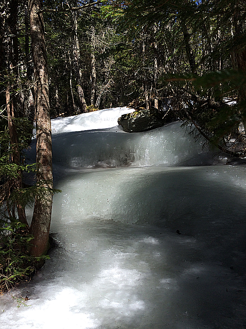
This was incredible to hike through!
gnarly ice flow descent!
Ice flow trail in the Wildcat Col
Mount Washington from Wildcat D Peak
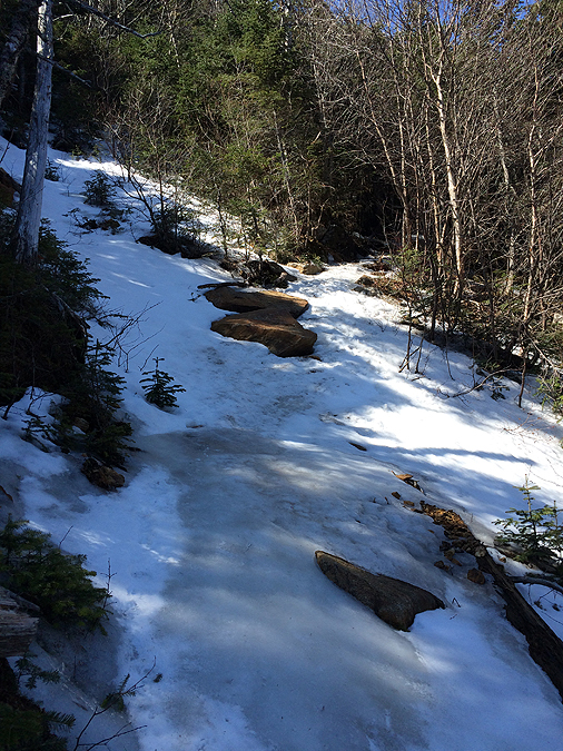
Snow melting away from the Polecat Ski Trail
Elevation over distance profile (click here for more info)