Showing posts with label Mount Hight. Show all posts

Dog Day Afternoon . . . The Carter Range

Date of Hike: 3/8/19

Nineteen-Mile Brook Trail: 1.8 miles  /  Carter Dome Trail: 1.8 miles  Carter Moriah Trail: 5.1 miles  /  North Cater Trail: 1.2 miles  /  Imp Trail: 3.0 miles  /  Camp Dodge Cutoff & NH16: 0.8 miles
Total Miles: 12.6 (5,062 feet elevation gained) Garmin Forerunner 920XT

Trip Report:
- Friday I took a vacation day to join Larisa and Todd for a high snow pack hike of Mount Hight, Carter Dome, South & Middle Carter.  Also joining us were our furry friends Sarge, Toby, and Dylan.
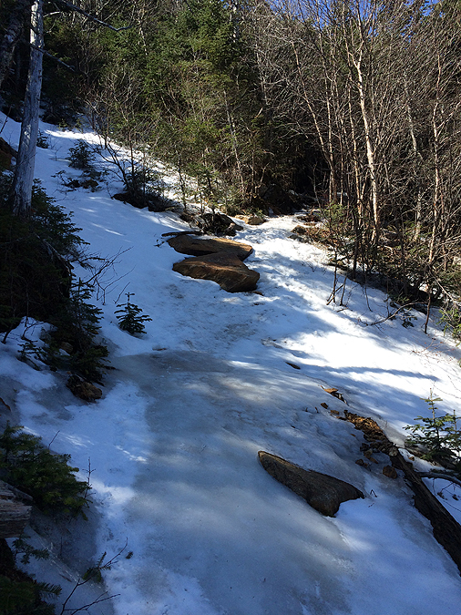
- The weather was in the low thirties with no wind, we wore our snowshoes from start to finish which were needed as the snow was soft along the ridge with wind drifts between Zeta Pass to Middle Carter before running into another pair of hikers.
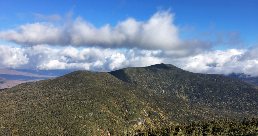
- The two highlights of the day were the amazing views from Mount Hight and the high snow pack above the shrub hike up to Carter Dome revealing views that I have only seen once before almost ten winters ago when the mountains last got hammered all season long with several snow storms and consistent cold temps.
- The high snow meant hiking/fighting through the tops of trees in spots along the ridge but I honestly didn't think it was too bad considering what I had been reading from trail condition reports.  Maybe it's the bushwhacking adventures I have gone on that has muted my response to hiking through a low trail corridor in winter.
- Dylan, Sarge, and Toby had a blast running up ahead of us and playing with each other along the way.  On the way up Mount Hight, Dylan even bushwhacked for a little bit before showing back up behind us on our way up Carter Dome, we have no idea where he went but he seemed to have fun wherever it was!
- This was one of my favorite hikes of the Carter Range to date.  Usually, they are not too exciting but with the high snow levels and the winter wonderland scene it makes it a much more enjoyable hike. :)

 Toby and Larisa hike up to Mount Hight

Sarge on Mount Hight

Sarge close up!

Larisa and Toby with Mount Washington looming large across the notch

Ravine of the Raymond Cataract and Huntington Ravine

Sarge taking in the views :) 

Sage and his permanent old man face!

Leaving Hight and on the way to Carter Dome

Usually we are in the trees here

Awesome view-full hike along the ridge between Hight and Carter Dome 

Making our way along the A.T.

Way a day!

The gang heads north along the A.T.

South Carter summit

Summit treats!

Sarge hikes through the alpine meadow between South and Middle Carter

Chargin' Sarge :)

Hi daddy, do you have any treats for me on Middle Carter??!!

2016 MMD 50K Redux

Date of Run: 10/5/17

Pinkham Road B & NH16: 1.5 miles  /  Imp Trail: 3.1 miles  /  North Carter Trail: 1.2 miles  /  Carter-Moriah Trail: 4.1 miles  /  Rainbow Trail: 2.5 miles  /  Wild River Trail: 1.8 miles  /  Wildcat River Trail: 1.7 miles  /  Nineteen Mile Brook Trail: 0.2 miles  /  Wildcat Ridge Trail: 4.9 miles  /  Glen Boulder Trail: 0.4 miles  /  Direttissima: 1.0 miles  /  Old Jackson Road:  1.9 miles  /  Madison Gulf Trail: 2.1 miles  /  Great Gulf Trail: 2.8 miles:  Great Gulf Link: 0.9 miles:  Bushwhack & Hayes-Copp Ski Trail: 1.2 miles
Total Miles: 31.3 (10,171 feet elevation gained) AMC White Mountain Guide Online & Garmin Forerunner 920 XT

Trip Report:
- In 2016 I tweaked my knee twelve miles into the MMD 50K run in the White Mountains.  The result of the knee injury was I was unable to run and had to hike the remaining twenty miles.  It was pretty demoralizing since I was running really well that day.  So a little over a year later I decided to head back and rerun it to see how I would hold up when healthy.
- MMD is held in early August but the weather on this October day was eerily similar for the start, wet from overnight rain and humid.  Luckily, by the time I reached Mount Hight the clouds blew off and I had some great views.  An added bonus was seeing peak foliage during most of this run, which was especially stunning during the descent of the Rainbow Trail.  The fallen leaves blanketed the trail and hid the rocks and roots, so my downhill speed was a little slower than normal, but I was totally fine with this as I wasn't looking to run too aggressively.
- I only saw four people from the start at Dolly Copp to Glen Ellis Falls, and then about a dozen from Glen Ellis back to Dolly Copp.  Getting to run the Rainbow - Wild River - Wildcat River trails without seeing another person while traveling under all the colors was a really awesome experience.  As much fun as MMD is with the other runners out and about on the trails, there is something special about heading through this area all alone.
- Overall, I had a very successful re-run of the route, my legs were a little heavy as this was my fifth mountain 50K in twenty-six days, but even with tired legs I still finished in just over eight hours (8 hours 4 minutes).  Not a bad way to spend a fall day in the White Mountains!

Elevation over Distance.

Map of route.  This is from last year, this year I had to bushwhack through the woods to the Hayes Copp Ski Trail at the end of the Great Gulf Link as Dolly Copp Campground is closed do to construction.

 I start out just before 7AM and run Pinkham Road B and NH16 to the Imp Trail

Heading up the Imp Trail, it's not one of my favorites as far as being attractive, but during the fall it looks much prettier.

View from the Imp Face of a clouded in Presidential Range 

 Hiking up the North Carter Trail

Along the Carter-Moriah Trail, through an alpine meadow, past Zeta Pass, and over to Hight and Carter Dome

View of South and Middle Carter from Mount Hight

Up next, Carter Dome

Descending the Rainbow Trail, looking back at Carter Dome (bottom left), and looking out towards the Wildcat Range (top left)

Beautiful Birch Glades of the Rainbow Trail

Put the Rainbow Trail on your foliage hiking list!

More bright colors along the Wild River Trail

Wild River Trail

Carter Notch Pond and Wildcat A Peak

Hiking up the steep Wildcat Ridge Trail to A Peak

Carter Range as seen from Wildcat A Peak

Carter Dome

Carter Notch Hut system

Mount Adams and Madison from Wildcat Ski area

Wildcat Gondola and looking down to Pinkham Notch from an outlook on the Wildcat Ridge Trail

Pano of Pinkham Notch

Gulf of Slides

Ellis River, the lowest I've ever seen it!

Hiking up the Glen Boulder Trail and across the Direttissima

Old Jackson Road

Madison Gulf and Great Gulf trails

Trails taken from on the east side of Pinkham Notch (Imp - Glen Ellis)

Trails taken on the west side of Pinkham Notch (Glen Ellis - Dolly Copp)

A day after the hike, Sarge and I headed to Rhode Island for Columbus Day Weekend, where he received A LOT of attention!! :) 

April Ice Fest : The Carters & Cats

Date of Hike: 4/17/16

NH 16: 0.5 miles  /  Camp Dodge Cutoff: 0.3 miles  /  Imp Trail: 2.0 miles  /  Carter Moriah Trail: 5.2 miles  /  Wildcat Ridge Trail: 2.6 miles  /  Polecat Ski Trail: 2.4 miles
Total Miles: 14.0 miles (5,969 feet elevation gained) Garmin Forerunner 910XT

Trip Report
- Sunday's weather rose well over 50 degrees above 4,000 feet with plenty of sunshine.  The continued warm up made the ice rink trails a little easier to contend with, although I still had to step off trail a few spots to down-climb monkey style!
- I parked my car at Nineteen-Mile Brook trailhead and road walked up Route 16 and cut through Camp Dodge on my way to the Imp Trail, which was mostly bare ground until a quarter mile below the junction with the North Carter Trail.  The North Carter Trail was almost one continuous ice flow, but with the warm temps and moderate grades it was a walk in the park considering what it must have been like a week prior in colder conditions.  I also like to think I have become accustomed to the different kinds of ice on the trail, some I can walk right up, some I have to be very careful and be balanced, while others I shake my head and immediately head off into the woods.
- I took my time gaining the ridge as I was tired from Saturday's yummy Sandwich Range big mile hike.  Once I hooked onto the Carter-Moriah Trail the conditions improved, there was some decent snow mixed in the the ice, with even a few bare spots along the way.  I had been reading reports of a very territorial male grouse 'attacking' hikers between Middle and South Carter.  I spotted him between Mount Lethe and North Carter.  He made buffoonish clucking noises while he paralleled me off trail in the woods about teen feet away for a good fifty feet or so.  I said out loud "What, I'm not good enough for you??!!".  About six years back I remember hearing about a grouse on the rocky Branch Trail 'attacking' people, must be a relative!
- The Carters are not much to write home about, there are some decent outlooks here and there and a beautiful mini alpine meadow but the hiking for the most part is in the woods and not that attractive.  What makes up for the trek in the woods is the the short and steep side trip up and over Mount Hight which has expansive and fantastic 360 degree views.
- After Mount Hight I headed up to Carter Dome then made the steep drop down to Carter Notch.  Luckily, this side of the mountain gets a lot of sun so it was relatively tame compared to other icy spots.  There were only two times I had to veer off trail because I couldn't handle the ice, and once past the Outlook the trail was bare ground until the last two hundred feet.
- Once I bottomed out at Carter Notch it was time to head straight back up again for the 1000 plus feet elevation gain in just 0.7 miles to Wildcat A Peak.  I was so happy that it was very warm out or it would have been crampon time.  The awkward steep side hill sections must have been pretty tough going up and tougher going down in the colder temps.  Luckily, the snow and ice was soft and my microspikes where biting pretty well considering they are becoming a tad worn down from the abuse they have taken over the past three weeks.
-  Upon reaching the summit of Wildcat A I took a short break and prepared myself for the sh!t show that was ahead of me.  Conditions started off fine between A and B peak and then things got very interesting to down right comical between B-C-D peaks.  I have never in my life seen the ice flow that was taking up not only the trail but basically the side of the mountain heading into the Wildcat Col between Wildcat C and D.  It was a bout 100 feet of ice that must have been a foot thick.  It was really freaking cool and once again I really lucked out, it was close to sixty degrees in the col and the ice monster was easy to bite into, and while I had to go off trail a few times I was able to carefully make my way down most of it.  I don't think I'll ever see that kind of ice again on a stretch of trail in the woods for a long time so I'm happy I got to see it and hike it, although once is enough for me!
- After passing through the ice castle I made my way up to the observation deck on Wildcat D's summit where I relaxed for a little while before dropping down the ski slopes where I go picked up by Whitney.
-  Not a bad way to finish up my April Grid, 554 down 22 to go over the next three months!

The Imp Trail just before the North Carter junction

The North Carter Trail looked mostly like this, but with the warm temperatures it was a breeze with my microspikes

A nice little alpine bog area heading up to Middle Carter

Moriah and Shelburne Moriah

Mount Washington

The Great Gulf with Jefferson, Adams, and Madison

Looking towards my goal for the day the Carter to the Cats

Along the Appalachian Trail

Ice flow going up Mount Hight

South and Middle Carter as seen from Mount Hight

The Northern Presidential Range

Mount Washington

Next up, Carter Dome

Carter Dome summit

Ice flow down off Carter Dome

Carter Notch, the hut, and Wildcat A Peak

Cater Notch Pond and Wildcat A Peak

Hiking across the small slide on Wildcat A

Looking back down the small slide

Nice little ice flow just below A Peak

Cater Dome riding high above Carter Notch

Decaying snow and blowdowns just off trail

This was incredible to hike through!

gnarly ice flow descent!

Ice flow trail in the Wildcat Col

Mount Washington from Wildcat D Peak

Snow melting away from the Polecat Ski Trail

Elevation over distance profile (click here for more info)