Showing posts with label Humphreys Peak. Show all posts

Top of Arizona . . . Humphreys Peak

10/7/21: Humphreys Trail: 10 miles (3,500' elevation gained)

10/17/21: Humphreys Trail: 6.6 miles  /  Bushwhack: 0.3 miles  /  Ski Trails: 1.9 miles
Total Miles: 8.9 (3,500' elevation gained)

Trip Report:
- While staying in Flagstaff we were able to get up to the highpoint of Arizona twice, both times via the Snowbowl. I was hoping to check out the Weatherford Trail for the second ascent but it was two days after our second R2R2R, so our legs were not ready for another long mile day and there was still plenty of lingering snow left below treeline all the way to the ridge which would have made for slow going on trails we were unfamiliar with.
- Todd an I got up to the summit on the 7th before the snowstorm so below treeline was easy going up through the long and seemingly never ending switchbacks up to treeline.  Above treeline there was some snow and ice from a small higher elevation storm from a previous day but it was easy going above treeline and the winds were almost non existent which is a rarity for Humphreys Peak.
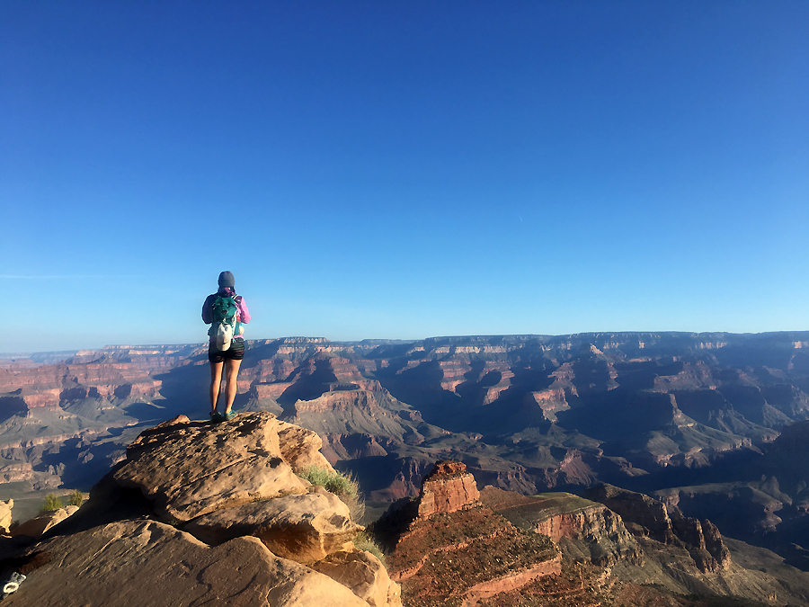
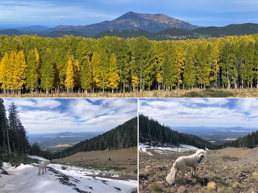
- Views along the ridge and summit were phenomenal and the Aspen trees near peak foliage made the sites even prettier.
- Temps were in the mid to high 40's with sunny skies to begin the day with some high clouds rolling in as we made our way back down.  We trail ran the descent back to the trailhead, with me "Supermaning" on a flat dirt section just a few hundred yards from the Jeep.  Quite the way to end a hike!
- Ten days later we headed back with Whitney.  Temps were a little cooler, in the low 40's, but the wind was whipping making it an invigorating hike at times.
- The hike to treeline was mostly over a slick packed snowy trail which none of us were looking forward to heading back down later in the day.  Once above treeline we battled the wind across the ridge to the summit, luckily there was less snow along the ridge than ten days ago which made rock hopping through the wind easier than anticipated.  The last few hundred feet up the summit cone the wind was howling so once summitting we snapped a few pics and got the heck out of there and made our way back across the ridge to treeline.
- When we reached the switchbacks and the snow covered trails I took us on a shortcut off trail to the ski slopes, this is the same shortcut Whitney and I did in 2017 to avoid the long slog back out over the slick trails.
- The bushwhack was open and easy and we made it to the ski slopes in about ten minutes where we enjoyed a much easier and faster hike back to the Jeep.

Sarge above treeline on the Humphreys Trail

Looking down into the Inner Basin

Todd and Sarge taking in the 360 degree views

Aspens closing in on peak foliage down at lower elevations in the Inner Basin

Summit photo with the pup

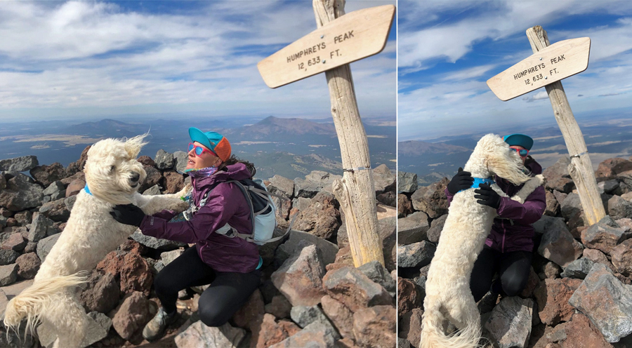
Sarge greats mommy with a kiss at the summit

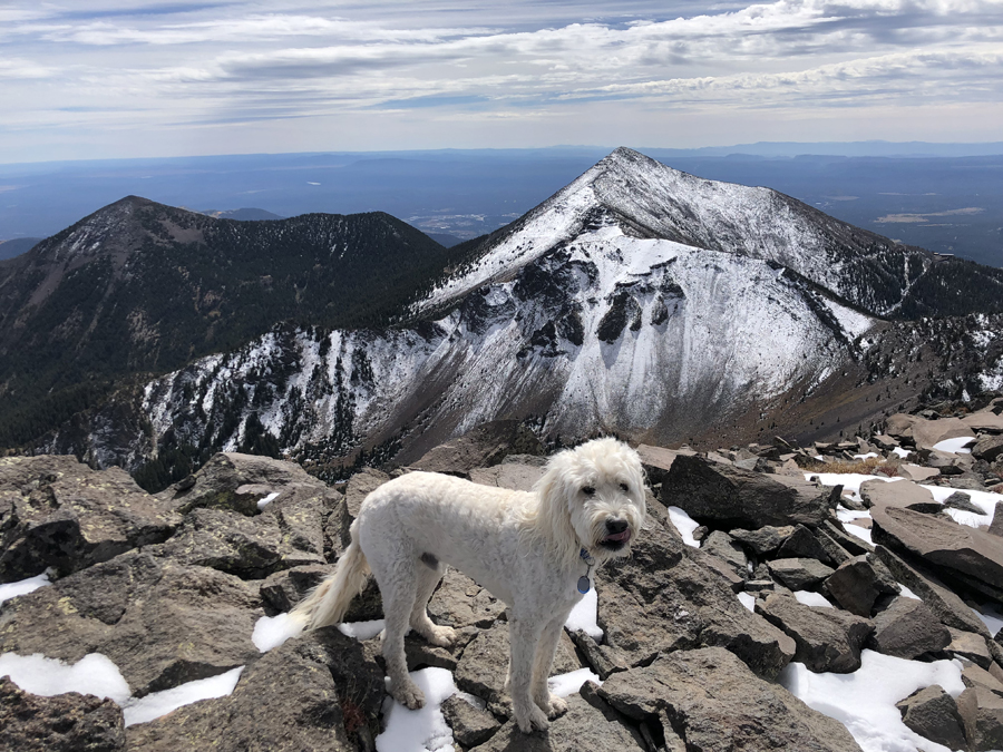
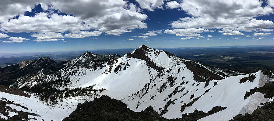
Agassiz Peak in snow and Freemont Peak with almost no snow behind Sarge

Jumping on the ski trails and looking northwest towards Kendrick Peak

Hiking in Arizona

I spent the month of May in Arizona, taking two weeks of vacation while working the other two weeks, getting up at 4:30 - 5AM to start work was a little strange but getting off at 2PM was pretty cool! (telecommuting from pacific time zone to eastern time zone).

The two weeks while on vacation Whitney was with me and my friend Diaz from my old college days joined in for a few days as well.  We had a great time hiking in Sedona, Flagstaff, and the Grand Canyon.  Below are links to the trip reports, I apologize for the grammatical errors, I quickly put these together so there will be edits to correct these soon, enjoy!

Sedona: Devil's Bridge, West Branch, Bear & Doe Mountain, Wilson Mountain

Flagstaff Part I: Buffalo Park, Campbell Mesa, Picture Canyon, Walnut Canyon, Mount Elden

Flagstaff Part II: Humphreys Peak (Hike & Ski)

Grand Canyon Part I: Rim to River & Back (Bottoms Up)

Grand Canyon Part II: Rim 2 Rim 2 Rim (Double Crossing)


 Devil's Bridge

View of Sedona from Wilson Mountain

Bear Mountain looking down into Fay Canyon

Whitney at OOH AAH Point

Zoroaster Temple looming high above the Colorado River

Whitney heading down the North Kaibab Trail during a r2r2r

San Francisco Peaks

Whitney makes her way up to Humphreys Peak

Arizona high point - Humphreys Peak

Whitney enjoying some skiing on her birthday :) 

Hiking in Flagstaff Part II : Humphreys Peak Hike & Ski

Humphreys Peak : Hike + Ski & Snowboarding 

May 21st:  
Humphreys Trail #151: 6.5 miles / Bushwhack & Ski Trail: 2.1 (8.6 miles 3,136 feet elevation gained)

May 22nd 
Wild Turkey / Logjam / Sundance / Spur Catwalk / Upper Bowl / Lower Bowl (5.6 miles, 2,710 feet elevation gained)

Trip Report:
-  On Sunday the 21st, Whitney and I headed to the Snowbowl to hike Arizona's highpoint, Humphreys Peak.  I had hiked this mountain once before, in May of 2014, it was an easy hike as the trail was snow free, this time however was a much different story!
- Humphreys Trail starts off at the bottom of the snowbowl ski area.  It cuts across one of the bunny slopes and heads into the woods and crawls it's way up to the ridge over four very long switchbacks.  Usually this is the easy part as it's in the woods, below treeline, and has easy grades, however after about 1.5 miles the trail was filled with snow along with some nasty side slopes.  Luckily, we both had microspikes, unfortunately one of Whitney's broke, but I was able to use the velcro strap from my hillsounds spikes to repair it enough so it wouldn't fall off.
-  We navigated the snow laden trail quite well, however other hikers we ran into weren't prepared, were getting lost, and having trouble staying upright, most of these hikers bailed at this point.
-  Once above treeline on the ridge, the trail was once again snowfree from abundant sun exposure.  It was a very easy ridge walk to the summit and there was no wind which is an abnormally for a peak that is notorious for high winds.
- At the summit we took a nice break, had lunch, and enjoyed the tremendous views.  It was a little hazy but we could even see the Grand Canyon to the north of us.
- On the way back we deviated from the trail at treeline and made a b-line through the woods to the ski slopes.  It was one of the easier whacks we've done, albeit with some loose rocks and dirt.  In a matter of twenty minutes we popped out on the slopes and had an easy walk back to the trailhead.  
- We also scoped out the ski trails for snow to see if there was enough lingering around for a return trip the next day, which there was, for Whitney's birthday and some late May skiing and boarding.
- For our fun in the snow hike & ski we both had to strap our gear to our backpacks, making them pretty heavy, Whitney had no issues considering she's hiked two 2,000 mile thru-hikes with excessive weight, but for me it was kind of uncomfortable and tiring carrying all that weight.
- We hiked up the ski slopes to the snowfield below Agassiz.  Whitney hiked a few hundred feet and skied back down to where we left our packs, I went about halfway to where she went and boarded back down.  It was kind of choppy so we headed down to a trail called Lower Bowl, and jackpot, we found a really fun run that we then did a few times.  We skied our packs to the bottom of the run, then just hiked up and skied down another couple of times enjoying the seventy degree weather and free skiing! 

 We start off hiking in the woods, through blowdowns and then snow

Looking at Agassiz Peak and the snow left, perfect to ski!

Agassiz peak from the Saddle

San Francisco Peaks (Agassiz, Fremont, Doyle) right to left

 Whitney makes her way up the last one hundred feet to the summit of Humphreys Peak

 San Francisco Mountain Range as seen from Humphreys Peak

Humphreys summit

Hiking back across the ridge and looking back towards Humphreys Peak

Arizona Snowbowl, plenty of snow left, but melting fast!

Hiking back down into the snow then bushwhacking

Nice open woods dropped us out onto the slopes

Not enough snow to ski here but easy to hike out next to it

Hiking back to the trailhead

Whitney hikes up and skis down!

Whitney on her first run of the day in the Upper Bowl!

Me cautiously (plowing) down the Upper Bowl  

The birthday girl :) 

Whitney's second run

Skiing the Spur Catwalk Trail

 Skiing the Lower Bowl

Whitney on another run :) 

Bottom of Lower Bowl

 Me boarding through the Lower Bowl 

If you look closely at the sticker in the upper right it's from Loon Mountain New Hampshire.  No matter where you go skiing you're sure to find something from NH!

Hiking the Grand Canyon and Arizona's Highest Peak / Road Trip

***Click on links to view reports and pictures***

Grand Canyon Marathon - 5/16/14:  South Kaibab / Bright Angel / Plateau Point (25.5 miles, 5,000 feet elevation gained)
 
Humphreys Peak - 5/17/14:  Humphreys Peak Trail #151 (10.0 miles, 3,200 feet elevation gained)

Horseshoe Mesa - 5/18/14:  Grandview Trail / Bushwhack (9.5 miles, 2,750 feet elevation gained)
 
Rim to Rim to Rim - 5/20/14: South Kaibab / North Kaibab / Ribbon Falls / Bright Angel (45.5 miles, 10,600 feet elevation gained)

PNC Park (Pittsburgh Pirates)  /  University of Notre Dame  /  Kaufman Stadium (Kansas City Royals)

 
Black Bridge over the Colorado River on the South Kaibab Trail
Colorado River as seen from Plateau Point
View from Humphreys Peak
 
Humphrey Peak Summit
   Grandview Point
 Horseshoe Mesa
 Split Rock in Horseshoe Mesa 
 Ribbon Falls
Silver Bridge
Plateau Point and the Grand Canyon as seen from the Bright Angel Trail's South Rim
 Go Pirates!  PNC Park, Pittsburgh, PA
 Touchdown Jesus!  University of Notre Dame
Go Royals!  Kaufman Stadium, Kansas City, MO