
Date of Hike: 5/16/14
Rim Trail: 5.0 Miles / South Kaibab Trail: 7.0 Miles / Bright Angel Trail: 5.0 miles / Plateau Point Trail: 3.0 miles / Bright Angel Trail: 4.5 miles
Total Miles: 25.5 (5,000 feet elevation gained)
Trip Report:
- When I was a teenager I was lucky enough to go on vacation to Arizona and hike the Grand Canyon with my parents. I remember how the views where out of this world, mules clopping up and down the trail, the dirt/clay trail turning my sneaker pink/red, and switchbacks...lots and lots of switchbacks!
- Friday, I had toyed around with the idea of doing a rim to rim to rim hike. However, if I did this hike my first day in the canyon I would have wrecked my body and would have to spend a few days after the hike up top with the tourists so I decided to put that off until Tuesday. My hike for the day was to head down the South Kaibab Trail, hook onto the Tonto West Trail over to Indian Gardens, and head back up the Bright Angel Trail.
- I stayed in Flagstaff and drove to the park really early, so early in fact (5:30 am), that there where no rangers at the gate so I got in for free! I drove to the Back County Exchange parking lot and decided to bypass taking the shuttle and take a nice five mile walk on the Rim Trail over to South Kaibab trailhead. The Rim Trail is a tourist trail; it's flat, paved and has many outlooks along the way. It's a nice walk early in the morning, there were a few people out and about to photograph sunrise and I even saw an elk (or a big deer) along the way. Temperatures where comfortable, in the high forty range at the beginning and warmed up to the mid fifties by the time I started my hike into the canyon.
- I was nervous and excited as I descended down the South Kaibab Trail. Within a few minutes I made a few observations, I was amazed how the switchbacks seemed to be carved out of the side of the mountain, the trail work was pretty amazing. Second thing that stuck out was how comfortable the footing was; no rocks, no roots, no bad footing that I am used to dealing with in the White Mountains of New Hampshire. The footing would be this great throughout the day, which is a good thing because there are other factors at play making up for the easy footing...the oppressive heat!
- The South Kaibab Trail drops down below the side of a rim wall for a little over a mile and then all of a sudden opens up as it travels over Cedar Ridge and down past O'Neill Butte. The views are huge and majestic, everywhere to the left, right, and in front of you are phenomenal. Red is the dominant color, with whitish/yellow lines carved into the side of the cliff walls as far as the eye can see with natural amphitheaters carved out into the walls in places. There are plateaus everywhere as well that are covered with shrubs making for a whitish, reddish, green look. This part of the trail was great as there were less swithcbacks, for a little bit anyway!
- The trail drops down from O'Neil Butte by, you guessed it, a series of swithcbacks. As you drop down you can see all the switchbacks, dropping steeply down along a redwall. The trail is all clay at this point and the shoes starting getting really dusty!
- After the swithbacks the South Kaibab Trail comes out to the Tonto Platform which is a nice levelish section with more huge views. I ran into a big black and yellow snake on my way through here. It didn't seem to care much about me as it just slowly slithered in the trail. Now views become even more intense as you look back and see huge walls rising above you and a huge drop off the far end of the platform awaiting you. There where a lot of people on the trail ad there are even bathrooms along the way on the South Kaibab Trail, no water though. I found it funny as there was a line for hikers to use the bathroom at Tonto Platform.
- From here I was supposed to hook onto Tonto West Trail, but I was having just too much fun so I decided I'd head down to the bottom and back up in a day!
- Once past the Tonto Platform the descent into the inner gorge begins. There where hikers and runners out and about as I dropped down on another series of switchbacks. I came across my first mule train of the day. They are a lot bigger than what I remembered from twenty years ago, they are as big as horses! The people riding the horses seem to be enjoying themselves, the mules look like they could care less about this, they just clomp up the trail pee and crap every so often!
- The Colorado River becomes more visible as you descend into the inner gorge below Skeleton Point, it's a vivid green color and you can hear it the closer you get. Next, the Black Bridge makes it's appearance, it looks so close, only about a dozen or so more switchbacks along the way! The Black Bridge is a modern marvel, basically it's built into the side of the canyon wall and suspends over the Colorado River.
- At the other side of the bridge another mule train came by, I watched them traverse over the bridge while taking a break before heading along the river and up to Phantom Ranch to check it out. I had stayed here with my parents about twenty years ago, and it looks exactly the same!
- I restocked on water and relaxed for a little bit before the long nine mile walk up the Bright Angel Trail in the ninety plus degree heat!
- Hikers and runners where everywhere. All types, too, and everyone was friendly. It was around nineish in the morning and I must have seen well over one hundred people. The great thing about the Grand Canyon is there are places filled with people (South Kaibab & Bright Angel Trails) and then there are places where you might not see anyone. It's just like Mount Washington, hike up Tuckerman Ravine and it's a highway, hike in the Great Gulf Wilderness and see very few until the top.
- Next up was to head back across the river over the Silver Bridge. I was expecting the trail to immediately head up into the canyon but was presently surprised as it traveled mostly flat above the Colorado River on a mix of dirt and sand. It was probably my favorite part of the day. The Colorado River looks intimidating as the current is moving really really fast. After about a mile the trail hooks a left and starts up dozens of swithcbacks through the Devils Corkscrew in the Vishnu Schist. The surrounding walls above the trail were narrow at the bottom then opened up a little bit, then got narrow again as I made my way below Plateau Point through the Tapeats Narrows and up to Indian Gardens.
- Indian Gardens was a zoo, as usual. The Temperature in the shade was eighty-five degrees, in the sun it was over ninety. I was having too much fun to head back up so I went out into the scorching heat to Plateau Point. I made sure to constantly drink water, eat my gummies, and lather up the sun block every forty-five minutes or so. At Plateau Point I met a nice couple from Lancaster, PA. Their sons were doing a down and up just like me and they were going to meet them at Indian Gardens and hike back out with them. Plateau Point offers some dramatic and killer views down and up, you can see the floor of the canyon below your feet and the rim walls rising above everywhere.
- Now it was time for the hike out up switchback hell called 'Jacob's Ladder.' I remember this as a young teenager; walking up in the heat with a water bottle and an apple as my white high top sneakers turned pink. Twenty years later I hiked up the switchbacks with my hydration pack and energy gummies as my black and yellow LaSportiva Raptors became dusty and turned gray.
- There are four and a half miles of up in the heat from Indian Gardens to the zoo at the top of the South Rim. There is water at the three mile and mile and a half mark, which comes in really handy. The trail is never steep, actually both the South Kaibab and the Bright Angel Trail are like a ramp, it reminds me of the lower section of the Lonesome Lake Trail.
- It was a fun hike out of the canyon, between the south rim to Indian Gardens is a mix of day hikers, runners, and tourists of all nationalities. I must have seen well over a hundred people in the last three miles or so. Lacking from the trails are dogs, I missed see goofy dogs on the trail like I do in the Whites!
- I finally hit a wall about twenty-five miles into my hike and a quarter mile from the top. I had only planned on doing half that mileage but other than general sourness it was totally worth. At the top there were people everywhere, it was a circus so I quickly made my way over the railroad tracks and back to my car where I realized I was covered in dirt and dust. I was really hot so I just unloaded the water that was left in my camelback all over myself cooling me off instantly. I stretched for a good twenty minutes, ate and drank, then bonked/relaxed in the back of the Jeep for a good half hour before feeling fine again.
- It was a thrilling return to the Grand Canyon and I couldn't have asked for a better day!
The setting moon, early morning along the rim Trail
The sun slowly falling below the south rim
Breakfast for this little guy along the Rim Trail
Looking down from the South Rim
Looking across to the North Rim
The South Kaibab Trail descends this rim wall and out to Cedar ridge
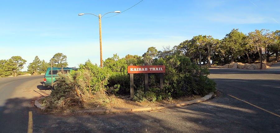
South Kaibab Trailhead
Mules have the right of way!
View from the upper walls of South Kaibab
Switchbacks!
This is where the views start to really open up
Trail turns to clay
Great views while descending along the rim walls
O'Neill Butte
Hiking along Cedar Ridge
South Kaibab Trail
At Cedar Point there is a bathroom
Huge views while dropping down from Cedar Point
O'Neill Butte
Looking back up to Cedar Ridge and up to Yaki Point
Red scarred walls and a red clay trail
The Grand Canyon, looking northwest
Looking back to where I just dropped down from
A nice flat section out in the open...
Before dropping down dozens of swithcbacks
The Colorado River makes it's first appearance!
Holes carved out by weather over millions of years
Looking over to Horseshoe Messa
Half way down!
More walls below the South Rim
Making my way down to Tonto Point
Zoroaster Temple makes it's first apparent
Tonto Point Plateau
Snake!
South Kaibab Trail, looking back up
A nice flat section along Tonto Plateau
A spot for hikers to take a break
Cedar Ridge
Emergency phone
Starting the drop down into the inner gorge
South Kaibab Trail
Looking back up
Skeleton Point
Long way down to the Colorado River
Every step there is a great view of the canyon!
Mule Train!
It's the cavalry!
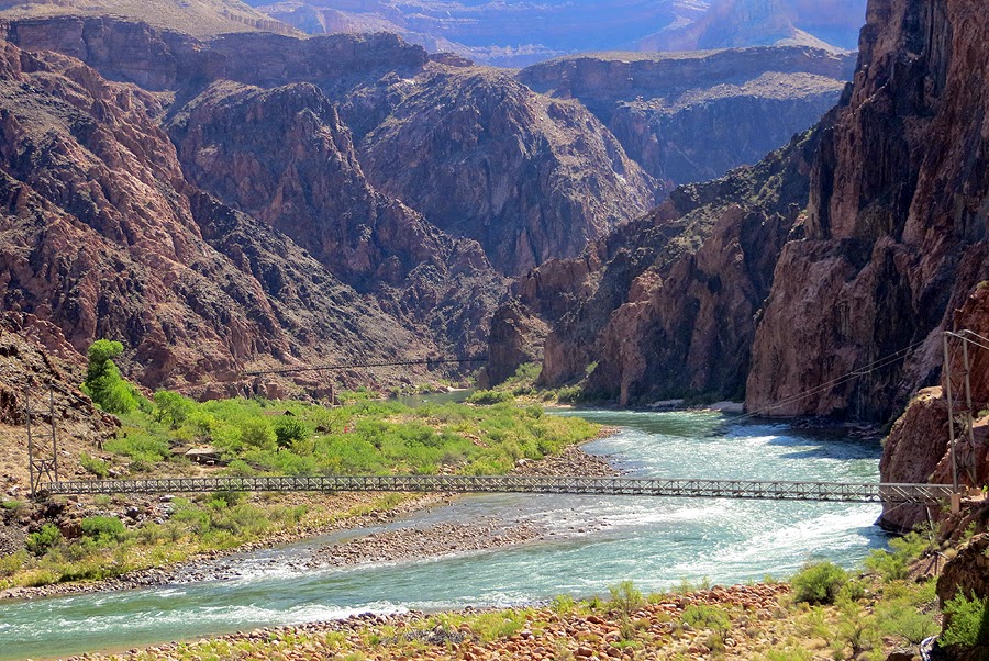
The Black Bridge makes its first appearance
The Black Bridge
Looking down at Bright Angel Campground and the Silver Suspension Bridge
Siler Bridge
Entering the Black Bridge
Pretty cool stuff right here!
Black Bridge
The Colorado River, looking east
The Colorado River, looking west
Colorado River
More mules!
A little history lesson
Black Bridge, notice the mules going across!
Bridge info
A couple of deers cooling off their feet
Mule pen at Phantom Ranch
North Kaibab Trail
Phantom Ranch
Ranch info
Phantom Ranch
Heading back to the South Rim
Bright Angel Creek info
Bright Angel Creek
Bright Angel Campground
Silver Bridge info
Silver Bridge
High rising cliffs along the Colorado River
Colorado River, looking west
Silver Bridge
Colorado River, looking east
The Bottom of the Grand Canyon
Silver Bridge
Sandy portion of the Bright Angel Trail
The Colorado River snakes through the bottom of the ravine
Me on the Bright Angel Trail
The Bright Angel Trail is mostly level as it heads around the lower canyon cliff walls
Emergency phone area
Heading back up into the canyon
An old mine cave
The Bright Angel Trail travels up what it called the Devi's Corkscrew
Everywhere you hike there are natural amphitheaters
Breaking out into the open for a little bit
Heading into the Tapeats Narrows
Hikers making there way to Indian Gardens
Amazingly, in this heat how healthy this tree looks!
It rminds me of the weather warning signs in the Presidential Range
Indian Gardens info
It was hot but not too hot!
Heading out to Plateau Point
Tonto West!
The Colorado River from Plateau Point
At Plateau Point
South Rim
Great views all around
Colorado River
I think this is what is called the 'Battleship'
Zoroaster Temple
Cacti line the trail near Indian Gardens
Heading to the South Rim in the afternoon sun
Water Pipe
Looking back down to Indian Gardens
This wall was covered in lime
Water station
Heading up Jacob's Ladder
Plateau Point and Indian Gardens
Plateau Point
Zoom in of Plateau Point
Bright Angel Trail arrow, just in case the trail isn't obvious!
Top of the South Rim
Route for the day, click here for more details
Amazing pics ! Makes me want to go there some day ! Thanks for posting
ReplyDeleteWendy