Showing posts with label Bunnell Notch Trail. Show all posts

Funnel into the Bunnell . . . Notch : Mount Cabot

Date of Hike: 3/13/16

Bunnell Notch Trail: 2.9 miles  /  Kilkenny Ridge Trail: 3.4 miles  /  Bunnell Notch Trail: 2.9 miles
Total Miles: 9.3 (2,855 feet elevation gained) Garmin Forerunner 910XT

Trip Report:
- After a two day trip to RI and catching the Bruins game on Saturday afternoon, a 3-1 win over the Islanders,  I wanted to take it easy on the trails Sunday morning after getting back home late Saturday night.  I looked at my maps and remaining grid peaks and Mount Cabot fit that criteria perfectly.
-  While not the most exciting mountain when it comes to 4,000 footers, I have grown to like it more and more over the past year.  The previous two times I hiked in from the closed Mount Cabot Trail, so on Sunday I decided to change it up and head in from the fish hatchery on York Pond Road.
- It's a relatively easy to moderate climb into Bunnell Notch over an old logging road for the first mile, followed by a climb through the woods next to a brook that flows down from Bunnell Notch for the following two miles.
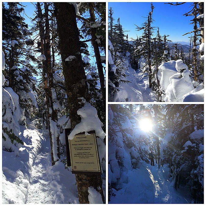
- Conditions this time of year usually include several feet of snow from top to bottom, but since winter never really arrived up in the White Mountains the trails took on a more mid April feel with bare ground, snow, and ice for most of its length.  Good news, this might be a year with very little lingering monorail, if any at all!
-  After three miles the Bunnell Notch Trail ends at the Kilkenny Ridge Trail junction, which is about a mile and a half from the summit of Mount Cabot.  After another few tenths of a mile the trail passes by the junction with the closed Mount Cabot Trail and from here becomes steeper and rougher for about a half mile until Bunnell Rock, where there is a fine view down into the valley and all the way south to Cannon Mountain and Mount Lafayette.  Once past Bunnell Rock the trail isn't as steep but is still a little bit of a grind as you gain the ridge and arrive at the Cabot Cabin and the clearing located just above it where a fire tower used to stand.  From the clearing to the summit is an easy ten minute walk to the wooded and very quiet summit of Mount Cabot.
- Although the calendar still says it's winter it was a great mid-spring feel hike and very enjoyable.  It was also nice to run into Marvin at the summit, kudos for making the long drive back and forth from RI over these past few years in every month, I know what that is like all to well! Also it was a pleasure to run into Karine, Jeff, and Mark.  Jeff & Karine were finishing up the single season Winter NH 48 - 4,000 footers, after already completing a single season Adirondack 46ers just a few weeks back, another impressive accomplishment to add to the many hiking goals they have achieved over the past few years, excellent job you two!

 Hiking along the old logging roads of the Bunnell Notch Trail through some clearings

The trail was bare ground in spots and hard ice where the sun doesn't penetrate through consistently

Goal for the day in sight from down below

There were some sections with snow, but still there wasn't much and most places were just icy

View from Bunnell Rock

Cabot Cabin

Signs spotted along the way, part one

Signs spotted along the way, part two

On my way back trough the town of Berlin I spotted a gang of chickens making their presence known...notice the two cats just playing it cool off to the side! #meow

Cabot-Patch : Mount Cabot

Date of Hike: 2/27/15

Bunnell Notch Trail: 3.0 miles  /  Kilkenny Ridge Trail: 3.6 miles  /  Bunnell Notch Trail: 3.0 miles
Total Miles: 9.6 miles (2,850 feet elevation gained)

Trip Report:
- Cabot, it's in the middle of nowhere and takes forever to drive to, made worse since the lower end of the Mount Cabot Trail has been closed since 2000 by an old crotchety homeowner, word is he spends his days yelling at clouds (click here for file photo).  Anyway, in the past (2010, 2012) I have hiked the closed Mount Cabot Trail but in the winter it's usually not broken out and it's best to head in from the Berlin Fish Hatchery, which is located about a half mile from the Canadian border (just kidding). Even though the trail is twice as long as the Mount Cabot Trail approach, it is a nice little hike with easy to moderate grades.
- Whitney and I got an early start and made great time over the perfectly packed down snowshoe trail.  The first mile is relatively flat as it heads over an old logging road with a nice partial view at times of Cabot and the Kilkenny Ridge.  After a mile the trail bangs a left off the logging road and meanders for a mile and a half through open hard woods as it ascends close by Bunnell Notch Brook before heading into a dense pine forest until reaching the junction with the Kilkenny Ridge Trail.
- The Kilkenny Ridge Trail heads into an open small Birch glade before heading back into the pine forest where it passes by the trail junction for the closed Mount Cabot Trail.  From here the trail gets steeper as it curves around and up past Bunnell Rock and eventually gains the ridge at the Cabot Cabin just below a clearing at the site of the old fire tower which some confuse as the summit, the summit is another 0.4 miles north.
- Whitney and I took a short break in the Cabot Cabin, which if I had to guess is in the same shape as a local meth lab, needless to say we didn't stay long before making our way up to the summit.  The last 0.4 miles to the summit is a gradual climb, it's not tough at all but if the trail wasn't broken out for us it would be difficult to stay on the trail as it looks like it could become a maze around the pine trees through this section.
- The summit of Cabot is wooded and not too exciting.  There used to be a sign that said Mount Cabot with the elevation on it, plus another small sign nailed to the back of a tree fifty feet away at the true summit.  However, some jerk stole both signs, boo!
- The hike back out was great, we took in the views from Bunnell Rock, enjoyed the descent along the brook through the open hardwoods, and spied some recent moose activity along the logging road making it back to the car before noon, and all under bluebird skies!
- This hike got Whitney closer to her single season winter completion (39 of 48).  For me it was the completion of my second winter round and sixth overall round of the 48 - 4000 footers, with only Whiteface and Cabot again before I complete my seventh round. Not a bad way to start the weekend!

 Heading down the Bunnell Notch Trail along and old logging road
 Looking back at our tracks in the early morning sun
Mount Cabot in view as we head along the logging road section of the hike
 Banging a left off the logging road into the woods
Heading up along Bunnell Notch Brook
 The Bunnell Notch Trail heads through some very scenic open hardwoods
 After three miles the Bunnell Notch Trail ends and we hooked onto the Kilkenny Ridge Trail and passed by the Mount Cabot Trail junction and through the pine forest
 Heading up Mount Cabot
 Deep snow above 4,000 feet!
 The trail gains the ridge...at the outhouse!
 Cabot Cabin and the view from the cabin
 Inside Cabot Cabin, it's a little dingy in there!
 Site of the old firetower
 Heading up to the Summit of Mount Cabot
 Behind the curtain of snow is the summit area
 Mount Cabot summit
 Kilkenny Ridge Trail heading north
 Descending off of Mount Cabot
 Waling back out along the logging road
 Trailhead
Route for the day, click here for details

Mount Cabot (#32)

Date of Hike: 1/2/10

Bunnell Notch Trail: 3.0 miles
Kilkenny Ridge Trail: 3.6 miles
Bunnell Notch Trail: 3.0 miles
Total Miles: 9.6 (3,000 elevation gain)
Click here for Trail descriptions

Trip Report:
- With sub-par weather and no views in the forecast I figured it was time to knock off one of my least favorite mountains...Mount Cabot
- On trail at 9:40am, Mount Cabot summit 12:15pm, finished 2pm. Temps in the high 30's to mid 40's, no wind, no good views.
- The highlight of the whole day was the ice covered untreated York Pond Road past the fish hatchery. I came across a sedan that could not turn around on the ice so I got out of my car and helped push it until it was able to grip the road and get out of trouble.
- As for the hike itself it was very uneventful, Bunnell Notch Trail is boring and has moderate grades so it takes forever. Once on the Kilkenny Ridge Trail things get steeper until it reaches Cabot Cabin so the hike goes more quickly eventhough it's harder. Once at the wooded summit I turned right around and started booking it off Mount Cabot-Patch.
- On the descent I ran into a bunch of hikers ascending, one of which (Bob) decided to turn around and hike with me for about 20 minutes or so as we talked about the White Mountains.
- Back at the car I packed my stuff up and navigated safely back out over the icy York Pond Road.

Pictures:
Bunnell Notch Trail
 Mount Cabot Summit
 Cabot Cabin
 Trailhead on York Pond Road


Mount Cabot

Date of Hike: 12/6/09

Bunnell Notch Trail: 3.1 miles
Kilkenny Ridge Trail: 3.8 miles
Bunnell Notch Trail: 3.1 miles
Total Miles: 10 (elevation gain 3000 feet)

Trip Report:
- On trail at 9:15am, finished around 2pm
- Weather was mid twenty's at trailhead, falling to mid teens at summit.  Cloud cover above 3500 feet until later in the afternoon.  2-4 inches of fresh powder on lower elevations and covering week old half foot snow above 2500 feet.  No wind until approaching summit then it was going at a pretty good clip above the trees
- Trails had a few small blowdowns, moved a few out of the way, some to big and had to walk over or around.  Bunnell Notch trail has boot sucking mud hidden beneath fresh snow.  Brook crossing was running high (about a half foot over rock steps) had to cross on a fallen tree about 50 feet up stream
- Cabot Cabin is a pretty cool place, it has a tiny room with a bench table, and a tiny room with four bunks which do not look to comfortable!
- I wanted to do a loop over to Mount Horn back to the car via Unknown Pond Trail, but with limited views, a long ride back to RI ahead of me, and the gate being closed at 4pm I decided not to
- Ran into only two groups of people, a group of about six doing Waumbek and Cabot, and a group of three trying to bag Cabot but were running behind on time
- This hike completed all 48-4,000 footers in the past 6 months.  My goal in the future is to do single season completions, which I think I can do for Spring, definitely Summer and Fall, but probably not Winter because of the long drives from RI, short days, and of course expen$e$!
- First time hiking Mount Cabot since 1993, back then you COULD hike up the Mount Cabot Trail!!

Picures: click here for all pictures

Kilkenny Ridge Trail Junction
Cabot Cabin
View from Bunnell Rock
Kilkenny Ridge from Route 110

Mount Cabot (4,170 feet)

Mount Cabot from "The Horn"

Mount Cabot is the furthest north of the White Mountain 4,000 footers.  It is a wooded summit with no views.  The lower section of the Mount Cabot trail has been closed by a local land owner for more than a decade which means the main route is now via the Bunnel Notch and Kilkenny Ridge Trails.  0.5 miles from the summit is the Cabot Cabin and a small open area just above the cabin where a fire tower once stood with ok views.  This is not as exciting as most other 4,000 foot peaks but great for beginners because of the moderate grades and good footing on the trails.  The surrounding peaks and ponds around Cabot along the Kilkenny Ridge are a very nice area to hike and explore (The Horn, Unknown Pond, Rogers Ledge)

Trails I've Hiked

Mount Cabot Trail: 3.9 miles, elevation gain of 2,700 feet. Be advised the lower section of the Mount Cabot Trail has been closed by local landowners since the 1990's, if you are able to hike the trail it is becoming more and more overgrown and muddy. The Mount Cabot Trail has moderate grades the whole way but the trail below the Kilkenny Ridge is eroding, muddy, and usually a wet mess from a decade of backed up water bars.  Once the Mount Cabot Trail joins the Kilkenny Ridge Trail it becomes a little steeper until passing by Bunnell Rock before gaining the ridge where it passes by Cabot Cabin and gradual makes it's way to the wooded summit.  There is a summit sign posted, a hundred feet beyond the sign is the actual high point with a summit stick nailed to the back of a tree.

York Pond Trail / Bunnel Notch Trail / Kilkenny Ridge Trail: 4.8 miles, elevation gain of 2,900 feet. This is the main route to the summit of Mount Cabot.  The trail has easy to moderate grades with decent footing and since it now gets more use it has been kept in good shape and is pretty easy to follow. The trails to the summit are very ho-hum but there is a lot of moose activity on the lower end along the old logging roads, so keep your eyes out for them early in the morning or late in the afternoon around dusk.

Trip Reports:


July 4th, 2016: Unknown Pond Trail, Kilkenny Ridge Trail, The Horn Spur, Kilkenny Ridge Trail, Starr King Trail

May 22nd, 2016: Bunnell Notch Trail, Kilkenny Ridge Trail, The Horn Spur, Kilkenny Ridge Trail, Unknown Pond Trail

March 13th, 2016: Up and down York Pond, Bunnell Notch, and Kilkenny Ridge Trail

October 23rd, 2015: Up and down the closed Mount Cabot Trail

September 28th, 2015: Up Starr King Trail and across the Kilkenny Ridge Trail (Kilkenny Ridge Traverse)

September 17th, 2015: Up and down the closed Mount Cabot Trail (RUN NH48)

April 25th, 2015: Up and down York Pond, Bunnell Notch, and Kilkenny Ridge Trail

February 27th, 2015: Up and down York Pond, Bunnell Notch, and Kilkenny Ridge Trail

August 31st, 2012: Up and down the closed Mount Cabot Trail

January 2nd, 2011: Up and down York Pond, Bunnell Notch, and Kilkenny Ridge Trail

November 14th, 2010: Up and down the closed Mount Cabot Trail

December 6th, 2009: Up and down Bunnell Notch and Kilkenny Ridge Trail