
Date of Hike: 10/23/15
Mount Cabot Trail: 7.75 miles (2,864 feet elevation gained)
Trip Report:
- On Friday I spent the early afternoon hiking up Mount Cabot from Heath's Gate. It was a quick and very quiet hike as I would see nobody the whole way up and down. My route for the afternoon would be over the old Mount Cabot Trail which is no longer maintained, it's a little muddy and eroded in spots but generally easy to follow. I made sure to not stray from the easement (an old logging road that travels between private property). It's a nice alternative from the hike on the northern side of the mountain from the Berlin Fish Hatchery, it's a little bit shorter mileage wise but pretty much has the same feel to it as they both head over old logging roads before heading through the woods into Bunnell Notch. There are some old blazes here and there, I spotted three, and a sign that reads 'Last Water Before Summit' at the Bunnell Brook crossing. There is a spooky feeling to the old trail, it doesn't see much use and you're just as likely to see a moose on it as you are another hiker. I saw neither, but did hear a dog barking off in the distance, I always hear a dog barking while making my way up the old section, maybe it's a ghost dog!! #boo :)
Starting from Heath's Gate I take the old logging road
If you're not familiar with the old trail it might be a little confusing as the easement crosses the old Kilkenny Railroad, which is now indistinguishable and a private property utility/ATV road
Heading up the old logging road
After three quarter of a mile there is a clearing, the trail heads to the left and into the woods
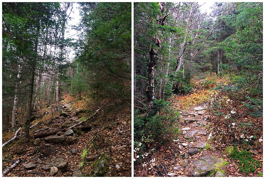
Once in the woods the trail remains a nice hike over the old road but then becomes eroded
It takes on more of a 'path' as the road narrows then turns into a 'trail'
The crossing of the Bunnell Brook, if you look closely at the tree leaning over the brook there is a sign that says Last Water Before Summit. This sign must have been placed here shortly before the trail was closed in 2000 because it is still in excellent shape
Once past the Bunnell Brook the trail finally starts to climb through open woods, in the late spring and summer it's overgrown with hobble bush through here but in the fall it's more open
Old blazes and illegally blazed painted yellow tin discs on trees
After two miles I hook onto the Kilkenny Ridge Trail and ho-humbly make my way up to the summit
View from Bunnell Rock, looking towards Lancaster
Gaining the ridge I make my way past the Cabot Cabin and it's tiny toilet in the woods
Mount Cabot summit area
Summit of Mount Cabot, last time I was here there was no summit marker. Hope this one stays up for awhile
A frosty Mount Cabot summit
I looked in the woods behind the cabin and found some old fire warden junk
Descending back down the old Mount Cabot Trail, another blaze spotted
Flagging, around some of the muddier sections, and old pipes along the way helping with drainage
A very old blowdown just taking on a life of its own along the trail
Reaching the bottom part of the in-the-woods section of the Mount Cabot Trail
Back out into the open section along the old logging road
Heading back by the gated section and along the easement
Heath's Gate
Signs spotted along the way, nothing to see here people :)
Route for the day
Nice pictures. I did this trail 2 years ago. I was amazed at how well it's kept up without any maintenance. On my way back to the car the landowner was waiting for me at that spot where the trail enters the woods (picture #4). He chased me and my hiking partner on an ATV and kept threatening us. It was an interesting day and a story to tell my grandchildren. Based on that experience, I now know what a curmudgeon looks like.
ReplyDeleteJesus, I've heard stories of hikers getting chased a long time ago but I thought he'd moved away or stopped harassing hikers! Talk about 'Old Man Yells at Cloud'.... Sorry you had that experience and you're right it's something you can tell your grandchildren and laugh about looking back. I'd been lead to believe he has no right to chase you away if you stay on the easement as that old road isn't his property. Hopefully I don't ever have to experience his wrath!!
DeleteYou are correct. There are two things against him 1) the easement in the land deed and 2) right of way laws. He's lost cases in court over this (from what I've read). There is a reason the trail is "not maintained" instead of "closed". It's a gamble whether you run in to him or not.... My favorite part was when he pulled out his flip phone and took a picture of me to show the authorities (or so he said). So I pulled out my little point and shoot camera and returned the favor. LOL!
DeleteWow! Way to play it cool with the phone! I can understand him being upset if hikers were being disrespectful or parking where they weren't supposed to but everyone I know who still uses the trail, which isn't many, are very respectful and quietly hike up the old logging road into the woods. A month or so ago my girlfriend and I hiked the Kilkenny Ridge Trail and noticed the York Pond Trail in Willard Notch, which was another trail that was 'closed' by the landowner in 2000, had a homemade sign saying it was now flagged from there to Heath's Gate. I'm hoping to check that out in the future too if possible.
DeleteChris, have you hiked this recently or know any one who has?
ReplyDeleteI haven't hiked up the old trail in a couple of years, and I haven't seen anyone do it recently either. Probably hasn't been hiked on since before the snow started falling in December. Every so often people hike it in the winter, but the tricky part is the parking, there's not much room to park and if the little pull off isn't plowed then I would advice against using it to not upset the land owners on the road.
DeleteGood news, two of my friends hiked past Waumbek yesterday. Here is what they had to say..." Packed trail to Waumbek, no signs of any travel beyond that. Snow cover was mostly breakable crust. Somewhat firm but we regularly punched through... sometimes only a few inches, sometimes nearly a foot. Route finding the trail was tricky with so much open woods - not much corridor to see... but we found blazes regularly. Open woods make it easy enough to bushwhack around obstacles or bypass messy sections.... Trail finding was impossible in several big blowdown patches. Most noteworthy was trying to find the trail from South Weeks towards the col with Middle - appears that section has significant microburst damage - countless trees snapped and down; and trail is impassable - we bushwhacked on its west side on the way down and it’s east side on the way back up. From the South Weeks Summit - just aim for the col... We saw lots of fresh moose sign on the Weeks - and a NH Fish & Game wildlife camera (in the col between middle and north) too. Pretty day out there - nice views from the Starr King and the Waumbek outlook. Tougher conditions than we had “hoped” for, but pleased to get the Weeks without deep trailbreaking... "
Deletei hiked both waumbek & cabot in the same day at the end of february. cabot via the closed trail. plenty of foot/ski traffic on the woods roads, but once it becomes more trail-like and less open road, no evidence of anyone having gone that way. parked on the side of the road, without complaint from anyone.
Delete