
Date of Hike: 6/18/16
Valley Way: 3.8 miles / Osgood Trail: 0.9 miles / Gulfside Trail: 0.3 miles / Airline: 0.6 miles / Lowe's Path: 0.3 miles / Gulfside Trail: 1.5 miles / Jefferson Loop Trail: 0.7 miles / Gulfside Trail: 0.8 miles / Clay Loop Trail: 1.2 miles / Gulfside Trail: 1.1 miles / Crawford Path: 1.5 miles / Monroe Loop Trail: 0.7 miles / Crawford Path: 1.5 miles / Eisenhower Loop Trail: 0.8 miles / Crawford Path & Webster-Cliff Trail: 4.3 miles
Total Miles: 20.0 (8,908 feet elevation gained)
Drive from Highland Center to Rooster Comb Trailhead: US-302, I-93, I-91, US-2, I-89, I-189,
US-7, VT-17, 9N, 7A, 6A, NY-73 (183 miles)
Rooster Comb Trail: 2.7 miles / W.A. White Trail: 3.3 miles / ADK Range Trail: 3.2 miles / State Range Trail: 2.9 miles / Haystack Trail: 1.2 miles / State Range Trail: 0.5 miles / Phelps Trail: 10.1 miles
Total Miles: 24.0 (9,941 feet elevation gained)
Daily Total : 44.0 miles, 18,849 feet elevation gained, 22.5 hours (Presi 6:57 / stretching, drive, gearing up 4:55 / Great Range 10:35) Garmin Forerunner 910XT
*These all day runs/hikes I take on are not affiliated with or recognized as a FKT, I just enjoy pushing myself and traveling through the mountains from sunrise to sunset and writing about my experience and posting pictures.*
Trip Report:
- Every year I try and plan a hike/run that is a little out of the box, last year it was Isolation to Owl's Head in a day (I2O), which was a fun and challenging experience (click here for trip report). This year's route, while not as unique as I2O, was definitely more physically and mentally challenging. During the past couple of months I wondered if it could be possible to do a Presidential Range Traverse and a Great Range Traverse in one calendar day. After looking over the maps and driving logistics I knew it could be done with a little luck, luck being weather and traffic.
- The Presidential Range Traverse and Great Range Traverse are the two signature hikes in each mountain range. Both have a different feel to it, New Hampshire's Presidential Range is exposed to the elements which makes it an adventure when weather comes rolling in. Views are huge while roaming above treeline for a dozen or so miles over knee-hammering rocks. Over in New York, The Great Range is ridiculously steep, rugged, and has some of the most dramatic 'in your face' views as the trail scrambles across the range to Marcy's summit.
- I decided I wanted to attempt this with another hiker, and knowing that Whitney would be away all summer hiking the PCT I had to find someone else who would be excited to take on the challenge, enter Kyle Legg! Kyle is an up and coming trail runner and shares the same enthusiasm towards the mountains and pushing one physical abilities. We hike/run well together, he sets a strong pace early on and I'm able to bring it home which works out to perfection over an all day affair.
- The original plan I had come up with had us driving to New York on Saturday and relaxing before starting at midnight and banging out the Great Range, driving to New Hampshire, and knocking out a Presi. Having done a dozen Presi traverses, while only two Great Range traverses, my thought was we would be more "at home" when we were the most tired, and the Great Range is a more difficult hike, unless there is weather. However, after thinking it over a little bit I concluded it really didn't matter which was done first, and it was just easier to start off with the range located in our backyard so to speak. So now all we had to do was get lucky with the weather to make an attempt, and boy did we ever luck out!
- The weather turned out to be as perfect as it can get. Our Presidential Range hike took place in conditions that might happen only ten times a year up there. Clear and calm, temps in the mid 40's to mid 50's, no wind...at all! We started at Appalachia at midnight and Kyle set a great pace up to Mount Madison under an almost full moon and a million stars, although the stars were muted since the moon was so bright. Around us the summit cones of Madison, Adams, Jefferson, and Washington lined the horizons in the darkness as the moon bounced off the rocks and lit the way. If the northern part of the range wasn't a mess of odd shaped boulders we would have been able to have hiked without headlamps.
- Twilight started creeping in on our way to the summit of Washington around 4:45AM. It was quiet and peaceful on the rock pile, where as in just a few hours hundreds of people would be running the road race to the summit with family and friends cheering them on during the final stretch to the finish line.
- For those familiar with the Presidential Range Traverse, it's almost all down hill from Washington with three easy ups along the way for Monroe, Eisenhower, and Pierce. We caught the sun rising from Mount Monroe, and as we motored through the rest of the range the ground glittered in gold from the sun reflecting off the morning dew, it was a beautiful start to one helluva day!
- Our goal was to do the Presi in 8 hours, we finished in 6 hours and 57 minutes. Phase one accomplished, phase two now began, the drive to New York. Before we hit the road we both stretched for ten minutes, changed our clothes, had a small bite to eat and started drinking coffee, getting on the road around 7:20AM.
- As for the ride to New York, I am familiar with it, just not under these circumstances. However, I had no issue with the drive, having spent several years driving from RI up to the mountains at all hours. Along the way we made a few stops to get a quick bite to eat and to stretch out. We lucked out and hit no traffic on US-7 which leaves Burlington's city limits. We were even lucky enough to catch only one red light through this section, a minor miracle! The drive which was just over 180 miles took 4 hours and 20 minutes, arriving at the Rooster Comb trailhead at 11:40AM. Phase two done, now onto phase three!
- It was quite warm out now but not humid, so unless we screwed up we should be able to pull this crazy 2-for-1 traverse day off. We started up to Rooster Comb at 11:52AM, once again Kyle set a great pace as we started up the range. Rooster Comb and Hedgehog are the two peaks at the lower end of the range, they both have easy footing and are a good warm up before the sh!t hits the fan just below Lower Wolf Jaw, here the trail turns into steep up and downs for the better part of the next 5ish miles before resembling more of a normal trail up to Haystack from the Basin/Haystack col.
- Our pace slowed down but we had plenty of time and were in no rush, we just had to be careful, not push the pace, enjoy the views, and have fun on the really cool parts of the trail, Gothics's cables and Saddleback's cliff scramble.
- For a big hike like this I break it down summit to summit, when on Upper Wolf Jaw I think "We're onto Armstrong," trying not to think about Marcy and what time we might be getting there, when it'll get dark on the way out to the Garden, where we will be when it does get dark, when we'll finish. Breaking it down peak to peak makes focusing easier for me and helps with keeping a steady pace, although at this point it was a slow but determined pace.
- Once making it through the section between Lower Wolf Jaw to Basin / Haystack col, what I refer to as the Garfield Ridge Trail on steroids, the trail becomes much easier again, although still steep at times and it's a grind since the two highest peaks have yet to be summited, the path is not as eroded and tricky as the murderer row of the Wolf Jaws, Armstrong, Gothics, Saddlecback, and Basin.
- After scrambling and climbing up the elevation ladder through the lower Great Range to the upper Great Range, one is rewarded with phenomenal 360 degree views heading up Haystack and Marcy's summit cones. It's quite the sight and a very dramatic one at that, with slides falling steeply down from numerous mountains in the Adirondack High Peaks region.
- We arrived at the summit of Marcy around 7:40PM as the sun was slowly fading down to the horizon on one of the longest days of the year. Unfortunately we could not wait around for almost another hour for it to set, we had a mission to accomplish. The descent to the Garden was not the time to run, jog, or rock hop, it was time to comfortably shuffle, (mountain version of speed walking) back down into Johns Brook Valley.
- 9.5 miles down the Phelps Trail had to be covered in just over four hours, my next goal was to get us to the Hopkins Trail junction along the Phelps Trail before turning on the headlamps. The reason for this was I remember there being a few cruddy sections up higher and two river crossings near Slant Rock and Bushnell Falls where I couldn't remember exactly how the trail went and wanted to get through in daylight, mission accomplished!
- Not too far from the Hopkins junction is the Johns Brook Lodge, from there it was 3.5 miles to the Garden, basically it was all over, time to zombie walk to the finish. I felt pretty decent but was exhausted from lack of sleep. It was now past 9:30PM on Saturday and the both of us had been up since 7AM on Friday (38 hours).
- We made it to the Garden at 10:30PM, finished! 22.5 hours, 42 miles, over 18,000 feet of elevation gained. There was no big celebration because we had to road walk back to Rooster Comb trailhead, luckily it's all down hill, however after the first few tenths of a mile the dirt road turns to pavement and that was really rough. It's about a 40 minute walk, and I felt like I was intoxicated if I didn't look exactly straight ahead and focus. If I looked up at the stars or into the woods my balance would suffer, it was a really strange feeling but kind of cool at the same time since I knew I was just beyond exhausted and would be fine once I was back at the Jeep in a few minutes. What was not fun and really scary was the song that was stuck in my head, so much so, that for a moment or two I thought, "No way that is in my head, someone is actually playing that song from one of these houses along this road." The song was, and I have no idea why, the Buggles, Video Killed the Radio Star, more specifically the last thirty seconds of the song. This is the type of shit that happens when the hike is officially over but you still need to get to the car, that and the odd food cravings, and at this moment it was White Cheddar Cheez-It Grooves, which luckily enough were in my Jeep!
- Anyway, we made it back to Rooster Comb Trailhead just after 11PM, sat on the ground, both had a beer and stuffed our faces before the bugs found us. Now it was time to find a place to sleep, yeah I didn't plan that out, but being familiar with the area I knew that the Keene Valley Hostel was basically right next to the trailhead. So we went there, they had vacancy for tent camping and with that we both took showers and then set up our tents and immediately fell asleep sometime around 12:30AM (41.5 hours of no sleep).
- We both woke up around 6AM, when you sleep in a tent you get up with the sun even if you're exhausted. After about and hour or so of just laying awake we got up and headed across the street to the Noonmark Diner for a well deserved breakfast before leaving the great state of New York and into Vermont where Kyle knew a great place for beers and lunch, the Three Penny Tap Room in Montpelier Vermont, where I had one of the best burgers I have ever had! Kyle not only sets a great pace on the trails but knows the great places to get really good beers and burgers!
- After lunch we drove back into New Hampshire and up to Appalachia and parted ways after an amazing journey through two of the most rugged mountain ranges in one day. I couldn't have had better company for this, thanks you Kyle for being a great hiking/trail running partner out there!

Elevation over miles profile, click here for more info

Route for the Presidential Range

Clock strikes midnight and we're off!

The weather warning sign. On this night we got extremely lucky, amazing weather, it was like a walk through an impressive and rugged rock garden.

The moon shining above JQ Adams

Just a lovely night for a walk above treeline :)

Kyle takes a stroll on the tracks for a few yards

Heading up to the castle (not in) the clouds

The soft glowing light from the sky as the sun lights up the horizon from below

Mount Washington summit

In just a few hours this place would be a zoo!

Heading down the oldest maintained trail in the U.S., the Crawford Path

Mount Monroe and Lakes of the Clouds

Lakes of the Clouds and Mount Washington

Closing in on Lakes of the Clouds Hut

Lakes of the Clouds and Mount Washington
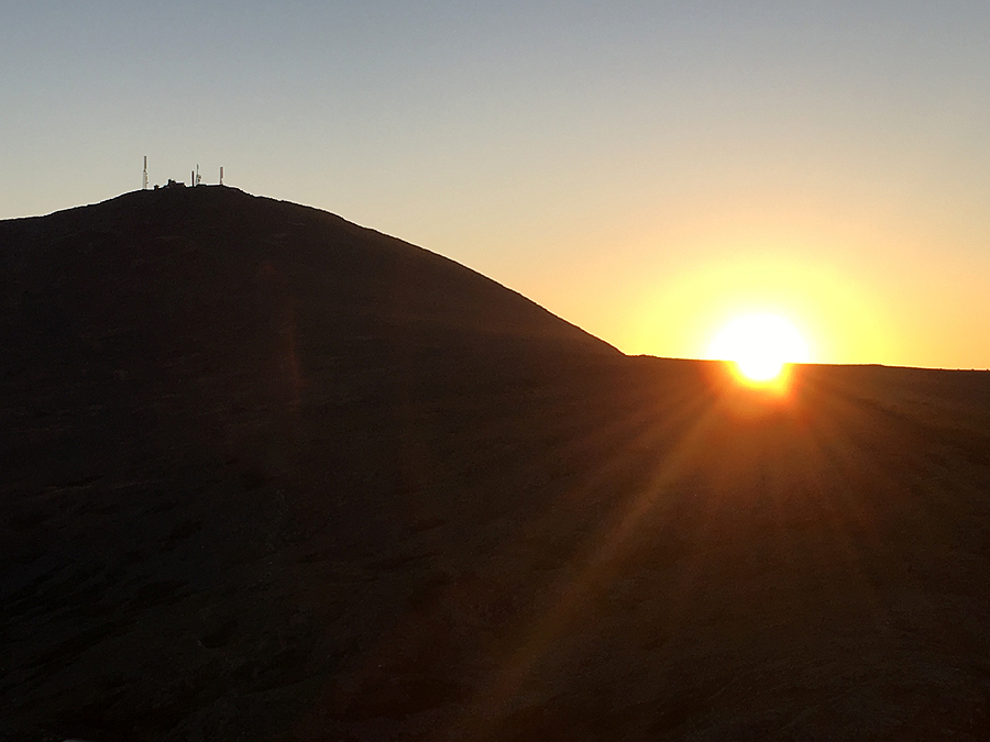
Sunrise over the southern shoulder, the Camel, of Mount Washington

Sunrise from Mount Monroe

Heading through the Southern Presidential Range during a breathtaking morning above treeline

Looking back to Monroe and Washington

Mount Eisenhower basks in the sun's golden rays

Heading across the Franklin Flats, AKA Forefathers Lawn, as the sun lights up the ground with a gold tint

On the way to Mount Eisenhower

The sun becoming more and more powerful by the minute as it rises above the Presidential Range

Kyle runs through the shadow casted by Mount Eisenhower's summit cone

Classic finishing picture from the final Mount Pierce

Next up the drive to Keene Valley, NY from Crawford Notch, NH :)
Look closely at the map, something funny is going on in Lake Champlain! ;) #smackers
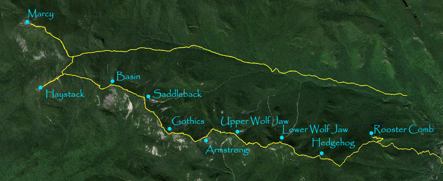
Route for the Great Range!

Rooster Comb Trailhead, and we're off for traverse #2 of the day!

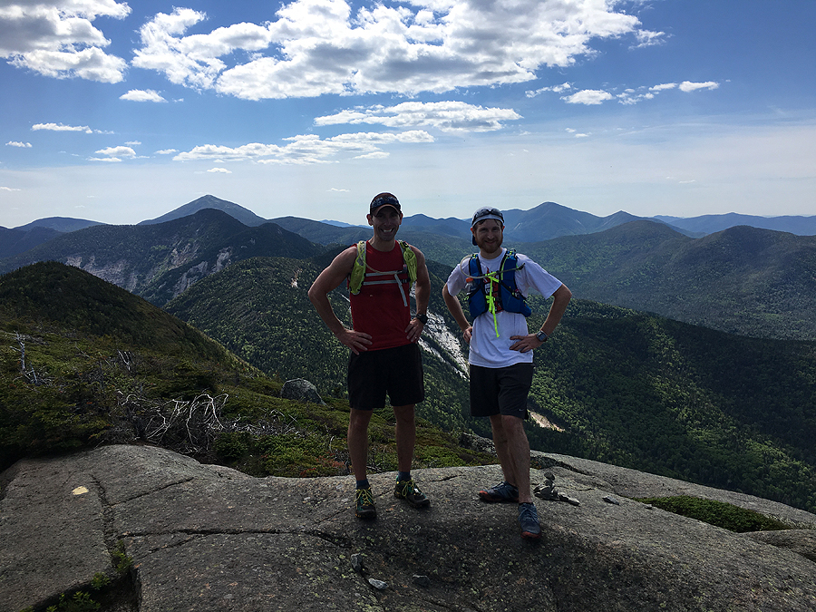
View of the Great Range from Rooster Comb's summit

Giant of the Valley and Rocky Peak Ridge

Well this sin't so bad...

Now this is Adirondack Hiking! Heading up Lower Wolf Jaw

Great Range from Lower Wolf Jaw

Kyle scrambles up a steep section of rock on the way to Upper Wolf Jaw

What I call 'Middle Wolf Jaw' and Lower Wolf Jaw from Upper Wolf Jaws summit

Next up, Armstrong

The famous ladder steps up Armstrong Mountain

Kyle heading up the ladder

Gothics, Saddleback, Basin, Haystack, and Marcy as seen from Armstrong

Saddleback slides
Summit of Armstrong

View from the summit of Gothics

Saddleback and Basin from Gothics

Upper Ausable Lake and the Pinnacle Ridge

Kyle heads down the Gothic cables

What an awesome stretch of trail!!

Here's a random hiker loving life right now!

Looking back to Gothics as we climb Saddleback

Basin's Slides

Basin Mountain, as seen from Saddleback

Kyle navigates through the Saddleback cliff

Kyle descends with Basin in view

Looking up at the lower part of the cliff

I've been through here a few times now. It's the only flat part through the range, an oasis of beauty nestled in-between the scarred walls that make up the Great Range

Looking back at Saddleback as we climb Basin

Saddleback Cliff

The short final scramble up to Basin's summit

And then there were two, Haystack and Marcy as seen from Basin

Kyle maneuvers down the last tricky section of the day to the Basin / Haystack col

What a view!! Basin, Saddleback Gothics with Pyramid in view as we head up Haystack

Mount Marcy dominating the sky as it basks in the late day sun

Lil' Haystack and Haystack

Kyle heading up the last half mile to the summit of Mount Marcy

Looking towards Colden and the Macntryre Range

Haystack as seen from Marcy

On top of New York's high point...it's all down hill from here!

One last look at the Great Range before we dip back below treeline

YUCK, this is why I wanted to get some miles in before darkness came!

Kyle at Slant Rock, last picture of the day. About two miles past this darkness overtook us just past the Bushnell Falls water crossing at the Hopkins Trail Junction. Hope everyone enjoyed the pics :)
Oh my God! That is insane Chris - and awesome! Congratulations to both of you! I can't even imagine trying this. Me and a couple buddies were whupped (but happy) after a Prezzie Traverse in 2010 and me and another buddy had to abort an "enhanced" Great Range Traverse that included Gray and Skylight in 2012 because of an ankle injury he had sustained in Colorado a couple months prior. Doing both in one day just blows my mind.
ReplyDeleteThanks, Rick! It was quite the day Kyle and I had, everything broke just right for us. That enhanced GRT sounds like a nice hike too, ending the day on Skylight would be really awesome. Sorry to hear your friend's ankle injury came into play and you had to abort.
DeleteYeah, it was for the best that we aborted though. It was really hurting him and continuing might have jeopardized the remaining two or three easier days. Actually, what we did was leave his truck at Rooster Comb TH the evening before and get a shuttle to South Meadow with our packs plus tent and sleeping bags. We slept a few hours then left camp at 2 a.m. Went via Marcy Dam and Lake Arnold to Feldspar Brook and up to Gray. Then Skylight, Marcy, and Haystack. Ended up bailing down Shorey Shortcut and Johns Brook just before Basin. Once we were down in the valley I went ahead and managed to catch a ride from The Garden back to the truck and return just as he got out.
DeleteRick: this report renewed my lust to attempt our Great Range Traverse again! Ankle is now surgically reconstructed, so it's plenty ready to be broken down once more ;)
DeleteChris: you guys are AWESOME! I really enjoyed reading this report--thanks for sharing.
Love the attitude and energy about wanting to take on the GRT again, hope you two get to attempt it in the near future!
DeleteAwesome! Love reading about your adventures. We completed our first Presidential Traverse on Saturday the same day as you did this and that was enough for me!
ReplyDeleteThanks, Owen! Saturday was a perfect day to be up there, hope you had a fun traverse and enjoyed all those miles above treeline :)
DeleteI'm constantly amazed by the hikes you pull off. Great job on adding this one to the list.
ReplyDeleteThanks, Adam. Hope you have a great summer hiking on and off trail!
DeleteHi Chris: 1. these are even better than your Hike NH pictures (if that were possible) 2. Now I know Satchboogie's real name! Glad you had such great weather for it, too!
ReplyDeleteHi Beckie, I had no idea about the Hike-NH post, I just went on read Kyle's post, glad he posted it on there for you guys to read. Hope you get to enjoy some long summer days out on the trails in the next few months :)
DeleteAbsolutely incredible journey, great to see hikers out there who push themselves physically while being careful and prepared. Thanks for writing about it and posting so many wonderful photos.
ReplyDeleteStacy & Ben
studs
ReplyDeleteThanks, Steevo!
DeleteI can't believe the guy from the FKT site shrugged you two off when you submitted this for one. Obviously he didn't read this report you submitted or bother to ask any of the north east FKTers about you, who all respect and enjoy your new routes you have been putting together for years!
ReplyDeleteIt would have been a great addition to the site and the response on his end was smug and uncalled for. I really enjoyed the part where he told me what we should have done instead of doing all that driving, which makes him look like a clueless fool considering what else I've done over the years.
DeleteI'm happy to keep my routes to myself and others that know me and/or stumble upon the blog. :)
Hey Chris,
ReplyDeleteLast July I did the Pres. Traverse. This July I'm doing the Great Range. One year of separation between the two seems a little more doable than a few hours. You guys are BadASS!
Anyways. Just a couple questions to ease my mind. I'm going to carry 4 liters of water out of the gate from Rooster Comb which should get me to Marcy. Is there a reliable water source to filter on the way back to Garden?
Looks like there are a couple brooks and such along the Phelps Trail?
Also, I've done the both the Pemi and the Pres. Where would you rate the Great Range as far as comparative difficulty? I got a little scared when you described one of the trails as "The Garfield Ridge Trail on steroids."
Thanks for the wonderful inspiration. Your trip reports always make me want to get after it!
Steve
Hi Steve,
DeleteThere is a reliable source between Basin and Haystack so you can always refill there too. But there are plenty of water sources coming down the Phelps Trail near slant rock, Bushnell Falls, and so on as you're basically paralleling a river on the way out.
As far as the GRT compare to the Presi or Pemi, it's more difficult, but not by much. The trails are more eroded and in much worse shape in spots, especially around the Wolfjaws to Armstrong. Between Upper Wolf Jaw and Basin are consecutive steep bursts up and down that feel like a flurry of punches, more so if it's hot and humid out. The beginning and the end are pretty tame, although the Phelps Trail IIRC was getting pretty eroded dropping off Marcy down to Slant Rock, but other than that it's a breeze.
Have a blast on your traverse, let me know how it goes cdailey@hpearce.com
Good Stuff Chris. Thanks for the info. It's always helpful to get your take. I'll update again after the hike - Looks like a 5 star weather day this Wednesday which definitely will help.
DeleteSteve
Hey Chris,
DeleteAll done. Wheeeew, that was a toughie. I lucked out with a nice, low humid 70 deg. day. Lots of mud out and branch reaching into the trail. You were so right saying "a flurry of punches". That last col after Haystack and upto Marcy had me yelling in frustration. My head just wanted to be up on Marcy with only downs ahead.
I only went through about 3 liters of the 4 I packed plus 3 lemonades at Johns Brook Lodge (which saved the day for my taste buds).
As far as comparative difficulty, I'd say that's definitely harder than the Pres. Traverse. You use your whole body much more on the GRT and it's just harder. There's not any cruising anywhere up to Marcy. It's work the whole way. On the Pres. I can always get into a rhythm. That's not happening on the GRT until about 2-3 miles down the Phelps.
Anyways. Thanks again Chris for putting it all out there.
I come to your sight, read about it, get inspired by the pics and narrative, then go and do it.
Great resource for us all. Please continue!
Steve