
Date of Hike: 3/9/13
Valley Way: 3.8
|
Osgood: 1.0
|
Gulfside: 0.9
|
Lowe's Path: 0.6
|
Gulfside: 1.5
|
Jefferson Loop: 0.7
|
Gulfside: 1.0
|
Bushwhack/Clay Loop: 1.0
|
Gulfside: 1.1
|
Crawford Path: 1.5
|
Monroe Loop: 0.8
|
Crawford Path: 1.5
|
Eisenhower Loop: 0.8
|
Crawford Path: 1.2
|
Webster Cliff: 2.5
|
Webster-Jackson: 2.6
|
.
|
.
|
.
|
-.
|
-
|
Total Miles: 22.5
|
Elevation Gain
|
8,660 feet
|
-
|
Trip Report:
- Saturday was going to be my biggest winter hike to date so I tried to go to bed early, unfortunately I was so amped up I slept a total of thirty minutes! My first winter Presi Traverse would be done on pure adrenaline.
- I left RI at 2 a.m. and pulled into Appalachia, strapped on my snowshoes, which would stay on for the next eleven hours, and hit the Valley Way trail at 6:15 a.m.
- I started at the same time a meet up group of a dozen or so friendly hikers (lead by Michael Blair, click here for the Random Group of Hikers page) were headed up to the Northern Presi's. I excused myself by each one and speeded up the trail making good time to treeline where the views were the best ever, over one hundred miles!
- I took a break outside the hut and chatted it up with some over-nighters before heading up the well broken out Osgood Trail. As I climbed, another presi traverser, Chris, was descending and we would run into each other over the next several miles before he disappeared around the Washington summit cone later in the day.
- The wind was whipping pretty good at the summit but it was already in the high twenty's so I wasn't worried at all. After taking a bunch of pics, (I would take around 350 on the day keeping about 150 as you'll see below), I zoomed back to the hut and took another ten minute break and met a guy who lives a town over from me and is cousins with one of my friends from high school. Small World!
- Next it was up to Mount Adams, it was still early enough that there were only two lightly made tracks in the snow, one was from Chris, and the other was from Adam Wilcox who came through here at dawn on a winter Hut to Hut Traverse, the first ever under 24 hour winter traverse (Click here to read his report).
- I decided to 'back door' Mount Adams, bypassing the Airline and heading in from Thunderstorm Junction and up Lowe's Path where I ran into Chris again. The wind was pretty fast at the summit but within an hour it would start to die down really fast.
- Now it was off to Mount Jefferson. I love this stretch of the Gulfside Trail, views down to the Great Gulf and Mount Washington are amazing and the snow makes the trail easy to hike. I booked it down to Edmands Col where Chris was taking a break. We chatted for about five minutes and he took off, a couple of minutes later I started after him. Chris decided to bypass the snowfield on the eastern side slope of Jefferson, I broke it out as it was drifted in, it was only two tenths of a mile but it was exhausting because of the steepness, luckily when I hit the Jefferson Loop Trail a hiker was descending so I followed his tracks.
- My body felt really strong physically but the lack of sleep was making me feel goofy. It was above freezing so the snow was becoming choppy and the sun was beating down on me. It was pretty rough going and I had to ration my water because there was no where to fill back up.
- Finally I made it to the summit where I ran into Mike, Gina, and Doug. I have hiked with Mike and Gina before and would end up hiking with them from Eisenhower to Jackson later in the day. They took off and I took a break and watched Chris finally make it to the summit. His bushwhack route to the summit was a brutal one but he made it, tapped the summit, and headed south! Impressive!
- Now it was time to count hikers, the trails were flooded with hikers everywhere, it seemed like they were rising out of the snow, I stopped counting at one hundred when on the summit of Washington!
- Before Washington I needed to hit Mount Clay, I thought I'd be smart and back door this one from the Gulfside Trail. Unfortunately I forgot which of the bumps on Clay is the true summit so I over shot it, 'snow-whacked' to the what I refer to the 'Clay - mini Clay' col, headed back north over two bumps, dropped back to the mini col, headed up to the other bumps and realized it was the northern most bump, my quads and hammys hated me for the extra work!
- From here I basically rolled my way back to the Gulfside Trail, took a nice pic of the cog tracks with Monroe behind it and headed to Mount Washington.
- Snow conditions suffered major blows here with the warm temps and bare-booters. I was expecting a hard packed highway, instead it was beginning to turn to a light mashed potato base.
- I hit the tracks, ran into Aaron and a few other hikers I knew and plodded my way up to the summit like it was my first hike ever!
- The summit area was a zoo, tons of hikers and skiers everywhere, yet somehow the observation deck was empty so I sat my ass down for ten minutes, took pictures, and relaxed until I saw a guy at the far end peeing between a hand rail and a rock. Check Please!
- Now it was part two of the hike, the easy part! 1.5 quick miles down to the hut. Passing a bunch of people along the way, most struggling with the mashed potato snow and badly sun burned! I caught up with Mike, Gina, and Doug again at Lakes of the Clouds Hut and took a fifteen minute break before heading up to Mount Monroe.
- Conditions changed rapidly on Monroe and south of Monroe until past Mount Franklin as rocks now where above the snow pack and my snowshoes took a major beating but still held up.
- From Monroe I tagged Mount Franklin, a bump on the side of the Crawford Path named after that dude who flew the kite in that lightening storm.
- The stretch between Franklin to Eisenhower contains a part of trail that includes what I refer to as the 'Franklin Flats'. It's a beautiful part of the trail that is totally flat, no one is ever on, and has magnificent views in each direction of the Presidential Range.
- At this point I kept telling myself I have two more ups, one for Mount Eisenhower and one for Mount Pierce and then I am done! I was exhausted, this was becoming one of the most tiring hike I have ever been on. Physically I was tip top but the no sleep, and the over packing (crampons, Ice axe, lots of cloths), and not much water was killing me slowly.
- I made it to the Eisenhower Loop junction and just fell to my knees in front of Gina, Mike, and Doug and took a nice long break with them before heading up to the summit.
- From here on out I would hike with them, they set a great pace and their presence was just what I needed to keep me from going coo-coo bananas Lincoln Woods - Wilderness Trail style.
- We made it to the summit of Mount Eisenhower, I took some pictures and then we were off. Mike, Gina, and Doug had butt sleds so whenever they could they zoomed down the trail. I played to part of the family dog running after them, panting, and drooling!!!
- The hike to Mount Pierce went well and the view from the summit looking back at the whole range was a sight for sore eyes as we took a ten minute break. This was supposed to be my "one last up" but the gang said we have to go to Jackson so it was time to rally myself for one last slog. Heading down to the Mizpah Springs Hut was easy and fast as we were now traveling along the Webster Cliff Trail. We took another nice break here before heading to Jackson. The trail between the hut and Mount Jackson in winter is never broken out too well. Doug took the lead and broke a great path with Mike and Gina packing it down nicely. I couldn't have done this without them, it was awesome to have the help.
- Along thw way we passed the Mount Jackson Alpine Meadow which was filled in with snow. It's a pretty cool spot and was really pretty with the bright sun slowly lowering over the Willey Range to the west. Finally, after struggling up the steep pitch below the summit I made it to the top and took a well deserved break and changed into dry clothes as I was soaked from falling snow from the trees over the past mile. I drank the last of my water and then we all booked it down the Webster-Jackson Trail. They were able to sled a majority of it and I just wanted to get to pavement ASAP that I found the energy to run down the mountain in my snowshoes!
- When I reached the Webster-Jackson Trail sign on Route 302 (5:35 p.m.) I collapsed and thought of how I would love to have a snack right now, I always loved snacks, and always will....That and I couldn't feel my feet and how I thought the snow would make a nice pillow, clearly I had lost my mind, luckily I didn't say any of this out loud in front of the others.
- It was a wild day and can't wait to do it again next winter! Mike, Gina, and Doug made for an fun last part of the hike and Doug drove me to the Highland Center as there was no way I was road walking that tenth of a mile to the building! I went inside and relaxed with a huge smile on my face and a little while later Gerri (Bob & Gerri) were nice enough to bring my car back to me from Appalchia, Thanks Guys!!!
- Perfect hike to end another season of winter hiking!

Appalachia 6:15a.m.

Valley Way

Valley Way

My favorite little section of the Valley Way in winter

Watson Path Junction

Valley Way

Well broken out Valley Way

Valley Way Tentsite

Valley Way

False summits of the Watson Path

Side slope on the Valley Way

Gaining the ridge

Snyder Ravine

Alpine Zone

Valley Way

JQ Adams peaking out above the scrub

Sun shining bright over the shoulder of Mount Madison

Madison Spring Hut

Osgood Trail

Well broken out path on the Osgood Trail

Osgood Trail swinging to the eastern side of Mount Madison's summit cone

Ascending Mount Madison

Osgood Trail

Mount Washington from the Osgood Trail

Osgood Trail

The final approach to the summit

Mount Madison summit ridge

Mount Madison Summit 8:30 a.m.

Mount Washington

Wildcat Ski Area

Wildcat and Carter Range

Osgood Ridge

Maine!

Mount Adams

Mount Washington and the Great Gulf Wilderness

Mount Adams

Madison Spring Hut and JQ Adams

Hikers ascending the Osgood Trail

Madison Spring flats

Mount Madison

Mount Madison from the Gulfside Trail

Bright sun over the shoulder of Mount Adams

Gulfside Trail South

Gulfside Trail North

King Ravine

Gulfside Trail

Approaching Thunderstorm Junction
Thunderstorm Junction

Lowe's Path to the summit of Mount Adams

Approaching the summit of Mount Adams

Mount Madison from Mount Adams Summit 9:35 a.m.

Mount Jefferson

Mount Washington

Durand Ridge

Descending the summit cone of Mount Adams

Gulfside / Isreal Ridge Trail Junction

Mount Jefferson, Clay, and Washington

Looking back at Mount Adams

Mount Jefferson

Gulfside Trail North

Gulfside Trail South

Mount Jefferson Shoulder and Mount Washington

Along the Gulfside Trail on the way to Edmans Col

Edmands Col

Edmands Col

Mount Adams from Edmans Col

Gulfside Trail

Eastern side slope on Mount Jefferson

Jefferson Loop Trail

Mount Adams

Jefferson Loop Trail

Approaching Mount Jefferson's Summit

The Great Gulf Headwall

Mount Washington

Mount Adams from Mount Jefferson's Summit 10:45 a.m.

View of Mount Clay, Mount Washington and the southern Presidential Range from the Jefferson Loop Trail

Descending Mount Jefferson

Monticello Lawn

Gulfside Trail South

Heading towards Mount Clay

Mount Clay

Sphinx Col

Gulfside Trail

Gulfside Trail

Mount Jefferson

Mount Jefferson and Adams from the Gulfside Trail

Mount Washington from Mount Clay 11:45 a.m.

Cog Railroad and Mount Monroe

Looking back towards Mount Clay

Cog Tracks

Northern Presidential Range

Cog Railway

Approaching the summit of Mount Washington

Mount Jefferson

Mount Washington Summit 12:40 p.m.

Mount Washington Summit Buildings

Mount Washington Observatory

Hikers making their way up the tracks

Moriah-Carter Range

Mount Washington Summit

The Crawford Path

Mount Monroe and the southern Presidential Range

Mount Washington Valley and Brenton Woods

Mount Washington's Summit Cone

Mount Monroe

Dogs on Washington! This dog is named Klaus and he was heading up to his 11th 4,000 footer!

Klaus playing on a side slope

Klaus playing on a side slope

Klaus the dog on his way up to Mount Washington

Mount Monroe

Mount Monroe

Lakes of the Clouds Hut

Lakes of the Clouds and Mount Washington

Hikers ascending Mount Monroe

Lakes of the Clouds Hut

Bright sun above Mount Monroe

Lakes of the Clouds and Mount Washington

Mount Clay and Jefferson

Approaching Mount Monroe

Mike and Gina having fun on the summit of Mount Monroe 1:30 p.m.

Mount Washington

Monroe Loop Trail

Cross Cairn on the Monroe Loop Trail

Descending back to Crawford Path

Crawford Path

Mike, Gina, and Doug heading towards Mount Franklin

Little Monroe and Monroe

Mount Monroe

Mount Franklin 1:50 p.m.

Descending to the Franklin Flats

Mount Monroe, Washington, Jefferson, and Adams

Crawford Path North

Crawford Path south to Mount Eisenhower

Crawford Path

Mount Eisenhower

Crawford Path

Mount Eisenhower Loop Trail

Mount Eisenhower Loop Trail

Mount Eisenhower 2:40 p.m.

Presidential Range

Mike and Gina sledding down the Mount Eisenhower Loop Trail

Crawford Path to Mount Pierce

Mike going for a ride

Mount Eisenhower

Crawford Path

Powerful afternoon sun

Mount Washington Valley

Crawford Path South

Crawford Path North

Summit of Mount Pierce 3:20 p.m.

Webster Cliff Trail

Webster Cliff Trail

Webster Cliff Trail

Mizpah Springs Hut

Mount Jackson Alpine Meadow
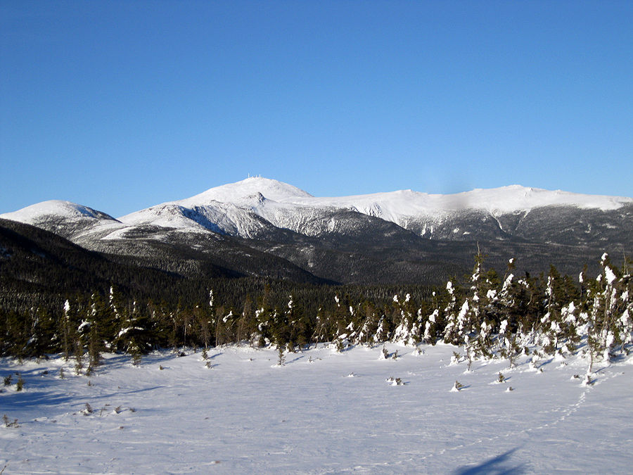
Presidential Range

Approaching Mount Jackson

Sun slowly descending

Alpine Meadow

Presidential Range

Presidential Range

Mount Jackson 4:45 p.m.

Descending from Mount Jackson

Webster-Jackson Trail

Webster-Jackson Trail

Flume Cascade Brook

Webster-Jackson Trail

Route 302 - 5:35 p.m.
Presidential Range Traverse: 6:15 a.m. - Appalachia / 8:30 - Mount Madison / 9:35 - Mount Adams / 10:45 - Mount Jefferson / 11:45 - Mount Clay / 12:40 p.m. - Mount Washington / 1:30 - Mount Monroe / 1:50 - Mount Franklin / 2:40 - Mount Eisenhower / 3:20 - Mount Pierce / 4:45 - Mount Jackson / 5:35 - Route 302
Great trip and great pics. You had the perfect day for that trip.
ReplyDeleteThanks! I had been waiting for a day like this for a looooong time!
DeleteAwesome pics and a great accomplishment! I have difficulty imagining doing this as a Winter dayhike. It took me and a couple buddies 18 1/2 hours in late August.
ReplyDeleteThanks Rickey! I got really lucky with the weather. The good thing about doing it in the winter....no knee hammering boulders to deal with!!
DeleteCongratulations on your first-ever Winter Presidential Traverse ... with only 30 minutes of sleep no less. I hope that we were able to help you get off to a fast start. We saw Geri in Edmunds Col and then saw Bob, Geri, and Alton in the parking lot at the end of the day. Not sure how you ended up with 400 pictures but the the ones you have here do a great job complimenting the awesome write-up.
ReplyDeleteMichael Blair
Thanks Mike, I've been making up the sleep I lost over the past thirty six hours, that's for sure! I always take a bunch of pictures, it ended up being a little over 350 actually. Every couple of minutes I stop and click away the camera does all thw work!
DeleteGlad you guys had a lot of fun up there on Saturday, I'll keep my eye out for you all on the trails this spring!
I love snacks after hikes too. Actually, I love them during them as well!
ReplyDeleteGreat pictures and funny and fabulous trip report!
WOW!!, Your a maniac, an unbelivable speed hiker, and still manage to take exceptional pictures. While you were speeding through the Presis, I was struggling to do less than half the distance and less than 1/3rd the elevation on Iso. Congrats on your great winter traverse. Hope you didn't try to drive back to RI that night.
ReplyDeleteThanks Marvin, no way I was driving back to RI that night. Originally I planned to hike on Sunday too but I came down with a nagging cough after the hike and something else came up that I wanted to take care of.
DeleteHope to see you out there in the spring, congrats on your finish!
This comment has been removed by the author.
ReplyDeleteEven with the aid of my trusty thesaurus, I can't come up with a word any better than AWESOME! So that word will have to do until someone invents a new and better word. :)
DeleteCongratulations not only for the traverse, but also for the excellent write-up, and for the photos which brilliantly capture all the key points of your journey!
John
Thanks John, it ended up being a perfect day up there and loved seeing all the hikers out and about!
DeleteAwesome post and fantastic photos! I was on Washington and Monroe that day. I'm actually in one of your Washington summit pictures (in green). We must have run into each other at some point! Enjoy the last few days of winter!
ReplyDeleteHi Allison! I'm glad you like the pictures, thanks! That was one of my favorite winter days to be up there so much fun. Hope you enjoyed your last weekend on the trails for winter. See you out there!
ReplyDelete-Chris
I'm enjoying your blog. Going to take my first Adirondack trip this July. Would you be willing to offer some advice on a good 3 day back country type hike?
ReplyDeleteSuper pic could you tell me what camera/lens are you using. Also i thought there was nobody else that had to drive as much as i do to get to nh, but you bet me this time!! i live 20 min north from Providence heh.
ReplyDeleteYour time was awesome i hope to get to that speed myself!!
I nightmart,
DeleteI'm glad you like the pics, thanks! I use two cameras, a Kodak Easy share 740Z and right now I'm using a Cannon PowerShot A3100. they work pretty good even though I'm always beating the crap out of them!