Showing posts with label Whitney Alana. Show all posts

Vote Early and Hike Often . . . Mount Lafayette and Lincoln

Date of Hike: 11/8/16

Old Bridle Path: 2.9 miles  /  Greenleaf Trail: 1.1 miles  /  Franconia Ridge Trail: 1.7 miles  /  Falling Waters Trail: 3.2 miles
Total Miles: 8.9 (4,154 feel elevation gained) A.M.C White Mountain Guide Online

Trip Report:
Tuesday, November 8th, 2016 - Election Day!  Did you get out and vote?  I hope you did and then I hope you did something productive, as in doing the complete opposite of sitting down in front of the TV and watching cable news!
- Luckily for Whitney and I the weather in the White Mountains was summeresque, with temperatures above treeline in the low 50's and no wind!  There was some gnarly ice to deal with for a half mile descending Falling Waters Trail from the summit of Little Haystack where our microspikes came in handy, but outside of that it was a perfect day up on the Franconia Ridge :)

***For new hikers to the White Mountains, this is one of the most popular and beautiful loop hikes in the northeast.  The trails are easy to follow with decent footing for the most part, and other than a few short steep sections, the grades a relatively moderate.  However, this time of year the weather is usally unpredicatble, cold, and very windy above treeline.  Expect snow and ice along much of this route between November and early May.

Whitney makes her way up a steep section along Agony Ridge

Agony Ridge up to Franconia Ridge as seen from one of Old Bridle Path's outlooks

Greenleaf Hut and Mount Lafayette

Eagle Lake and Mount Lafayette

Some ice in the shady spots just before reaching treeline

Cannon Mountain and Echo Lake from the Greenleaf Trail

Beautiful day up above treeline!  Kinsman Ridge in view across the notch

The Mount Lafayette spring is closed until late April!

The sun was shining brightly above us all afternoon

This little hundred foot steep stretch can be intimidating and dicey in the middle of winter when a steep snow field forms but today it was easy going

Making our way to the summit

Pemigewasset Wilderness

Looking across the Pemi at Guyot and the Bonds

Classic Franconia Ridge picture

Pano of Franconia Ridge, the notch, and Kinsman Ridge

Looking north towards the Presidential Range

Dogs on Lafayette!

Pemi Wilderness

Heading to Lil' Haystack with Liberty and Flume off in the distance

Pano of Mount Lincoln and the north end of the notch

Cannon and the Kinsmans

Mount Lincoln

Icy descent down Falling Waters Trail

Shining Rock

Cloudland Falls

Stairs Falls

Southwest is Best . . . Hiking Adventures in the Canyons of Arizona and Utah

It's taken me two months but I finally am able to post the report and pics from our hikes in the southwest, Enjoy  :)

In May I made my annual cross country drive to some of the most breathtaking places for hiking in Arizona and Utah.  After hiking solo in the Grand Canyon for two days my girlfriend Whitney flew into Phoenix to join in on the fun.  Below are trip reports with pictures from the hiking adventures we had over the following week.  The weather was unseasonably cool and rainy at times but we got lucky and were able to get in some phenomenal hikes between the storms and wild weather.  Some highlights were hiking to the bottom of the Grand Canyon and back up in a day followed by exploring an old cave and getting pelted with tiny hail the following day.  The wild weather followed us into Utah but we managed to gauge the forecast and hit up a cool little local slot canyon called Peek-A-Boo in Oderville.  Finally, the weather broke and we had three amazing days, first exploring the out of this world hoodoo formations in Bryce Canyon, followed by two days in Zion where on day one we scrambled across the knife edge of Angels Landing and climbed high above the canyon to Observation Point.  This all lead to our final and best hike of our trip, hiking the Narrows, sixteen miles, most of which was walking through a river as canyon walls rose steeply from each side of the river!

Click on the links below to read reports and view pictures

Thursday, May 21st:  Grand Canyon - Rim to River and Back

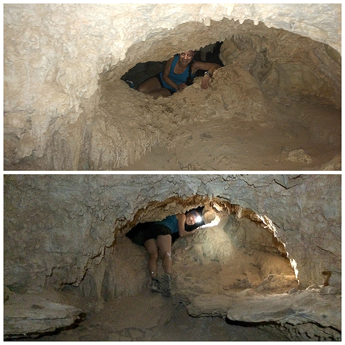
Friday, May 22nd:  Grand Canyon - Cave of Domes

Saturday & Sunday, May 23rd & 24th:  Horseshoe Bend, Rimrock Hoodoos, Peek-A-Boo Slot Canyon, Pink Coral Sand Dunes

Monday, May 25th:  Bryce Canyon

Tuesday, May 26th:  Zion Canyon - Angels Landing & Observation Point

Wednesday, May 27th:  Zion Canyon - Narrows (Top-Down)

Thursday, May 28th:  Lower Antelope Canyon

The Colorado River from the South Kaibab Trail 

 Whitney in the Cave of Domes . . . on her birthday!

 Horseshoe Bend (Whitney's picture)

 Rimrock 'Toadstool' Hoodoos

 Rad Slot Canyon AKA Peek-A-Book Slot Canyon

 The Pink Coral Sand Dunes was kind of lame...so I had some fun! #SMACKERS

 The hoodoos of Bryce Canyon

 Whitney along the knife edge of Angels Landing

 Zion Canyon from Observation Point

The Narrows!

Lower Antelope Canyon

Whitney's Winter 48 Finish - Wildcat & Carters Traverse

Date of Hike: 12/22/14

Wildcat Ski Trail:  2.7 miles  /  Wildcat Ridge Trail: 2.5 miles  /  Carter-Moriah Trail: 5.6 miles  /  North Carter Trail: 1.2 miles  /  Imp Trail: 2.0 miles  /  Camp Dodge Cutoff & Route 16: 0.8 miles
Total Miles: 14.8 (5,550 feet elevation gained) Garmin GPS Forerunner 910XT

Trip Report:
- Whitney kicked off winter with a bang by finishing up her Winter 48 - 4,000 footer list on the summit of Wildcat 'A' Peak.  Going into the day she only had two left, the other being Wildcat'D' Peak.  Joining in on the hike was Kyle, Denise, Kim, Barbara, and Mike.  We also celebrated Kyle and Denise's birthdays on the summit of Wildcat A as well.
- Whitney, Kyle, and myself ended up doing a Wildcats & Carters Traverse, while the other descended back down to the cars after hiking the Wildcats.
- We started off by hiking up the Polecat ski trail at the Wildcat Ski area.  If you are a hiker you now have to pay $10 for slope access to reach Wildcat D Peak.  Passes can be purchased inside the main building.  If you don't want to purchase a pass you can hike up the Wildcat Ridge Trail from Pinkham or do an out and back from Carter Notch avoiding the ski trails.
- We hiked up Lower - Middle - Upper Polecat trails and had pretty great views of the ravines of Mount Washington while ascending.  We started early enough that we didn't see any skiers until the last mile or so.  The conditions for skiing were pretty good as they zoomed by us down the mountain.
- Once we hit the top of the ski slopes we made the short steep burst up to the true summit of Wildcat D where there is an observation deck.  From here we hiked the numerous up and downs along the ridge which were buried in snow with lots of overhanging branches that were weighed down from the snow.  The footing is a lot easier through this section in the winter with all the rocks beneath the snow so we made good time over to Wildcat A.
- At the summit we celebrated Whitney's finish and Denise and Kyle's birthdays with yummy cupcakes before dropping down into Carter Notch.  The descent down is one of the steeper ones in the Whites and we had fun butt sledding in places and quickly made it down to the Nineteen-Mile Brook trail junction where we went our separate ways.
- Before heading up to Carter Dome we took a little break at Carter Notch Hut to warm up.  It had been a long time since I hiked up to Carter Dome, usually I'm descending it, and the first half mile is excessively steep!  With the deep snow pack hikers butt slide down this section.  We ran into a few and made sure to step off the trail letting them slide on down.  Along the way we ran into our friend Inna who was with a meetup group.  From here on out we only ran into one other hiker heading to South Carter so we had the whole ridge to ourselves.  Everything was broken out and packed down well the whole day making for good footing, which was great since this is a butt kicker of a hike with the numerous PUDs and the steep ascent and descent to Carter Notch jammed right in the middle.  The only obstacles of the day were the trees that were hanging all over the trail from being weighed down, Whitney hit her head and so did Mike, who drew blood.  The rest of us took indirect shots but we all made it out ok and had a blast.
- At the end of the day we saved mileage by cutting through Camp Dodge, it's a heavily used shortcut in the winter so consider using it if you are hiking the Carters.
- We made it back to the car just as it got dark and ended up heading to Red Fox for a yummy dinner to celebrate Whitney's Winter finish!

 Route for the day, click here for details
 Wildcat Ski Area
 Heading up the slopes with the Ravines of Mount Washington behind us
 Denise taking in the view over to Mount Madison and Adams
Hiking up the ski trails has a much different feeling than hitting the trails
 Making our way up to Wildcat D Peak
 Mingling with the skiers and heading to the summit tower
 Along the Wildcat Ridge Trail
 Kyle makes his way through the ridge
 Congrats to Whitney and Happy birthday to Kyle and Denise
 Carter Notch
Carter Notch Hut
 Ascending and descending Carter Dome
 Along the Carter-Moriah Trail
 The cool little alpine meadow heading to Middle Carter
 To the east is the Wild River Wilderness and the Baldfaces.  To the west is Pinkham Notch and the Presidential Range
 Middle and South Carter have wooded summits right off the side of the trail.  If you're not familar with the spot you would walk right by them!
 Heading over Mount Lethe to the North Carter Trail Junction
 Descending North Carter and the Imp Trail
 Making out way to Camp Dodge
Camp Dodge