Date of Hike: 9/23/17
Zealand Trail: 2.3 miles / A-Z Trail: 2.7 miles / Mount Tom Spur: 1.2 miles / Willey Range Trail: 3.4 miles / Ethan Pond Trail: 3.5 miles / Thoreau Falls Trail: 5.1 miles / Wilderness Trail: 0.9 miles / Abandoned Wilderness Trail: 0.8 miles / Bondcliff Trail: 6.1 miles / West Bond Spur: 1.0 miles / Bondcliff Trail: 0.80 miles / Twinway: 1.3 miles / Zealand Spur: 0.2 miles / Twinway: 2.9 miles / Lend-A-Hand Trail: 2.7 miles / Hale Brook Trail: 2.2 miles / Zealand Road: 1.0 miles
Total Mile: 38.1 (11,075 feet elevation gained) A.M.C. White Mountain Guide Online & 28th edition guidebook
Trip Report:
- The calendar reads fall but the temperature reads dog days of summer. It has been a two week stretch of hot and humid weather in the mountains, which is good and bad. Good in that you can pack light, usually this time of year I need hat, gloves, long sleeve, and a wind breaker for above treeline, none of which have been needed. The bad, you better be hydrating or you'll be in a world of pain when trying to pull off big mile day hikes, and consistent "trail run" pace becomes tougher to attain without overheating.
- My route for Saturday was another punishing hike/run, this time in and above Zealand Valley and Thoreau Falls (North Fork) Valley. Once again I had a time constraint, having to be home for puppy duty at 6pm.
- I started at 6:40AM from the end of Zealand Road on the Zealand Trail for the first 2.3 miles over relatively flat terrain. The foliage looked pretty good as I made my way to Zealand Pond and even better as I climbed 2.7 miles up to the Willey Range on the A-Z Trail.
- The Willey Range consists of Mount Tom, Field, and Willey. The trail does not have views but the summit areas have outlooks or obstructed views which are nice, although they are even better in winter with high snow pack.
- Descending Mount Willey to the Ethan Pond Trail starts out as disaster, the trail is steep, eroded, and undermined. It's a wild ride for about half mile where a wrong step could trip you up or have you sliding onto your butt over some loose dirt and rocks.
- The trail eases up as it closes in on the junction with the Ethan Pond Trail (Appalachian Trail), where I banged a right, and shortly thereafter I banged my right quadriceps and abdominal muscles as I took a fall over a flat section of trail. I don't fall too often, but when I do it's on a flat or a dirt part!
- After hiking/running the easy 3.5 miles through decent foliage in Zealand Valley, which I think is about a week away from peak, I hooked onto the Thoreau Falls Trail and dropped down to the North Fork where the foliage was spectacular. The trail was blanketed and the leaves were falling as I jogged along the North Fork branch of the Pemigewasset River towards the East Branch of the Pemi.
- At the Thoreau Falls bridge, which its fate is yet to be determined, I took a break to filter water and eat. The bridge needs some serious work, or needs to be replaced as it's in rough shape, however it's a man made structure in a wilderness zone so the powers that be most likely will remove it as the trail does not see much use. Personally, I hope they fix it, as it makes for a safe crossing many miles away from any trailhead during times of normal & high water.
- From the Thoreau Falls bridge I hiked to the Wilderness Trail, which I traveled on for almost a mile before crossing the East Branch at the site of the old Wilderness Trail suspension bridge. Since it has barely rained over the past two months the crossing was very easy, usually I have to wade across part of this crossing. Above the crossing I hopped onto the abandoned Wilderness Trail for 0.8 miles, the old trail is still easily followed, there are a few dozen speed bump blowdowns, but overall the abandoned part is in good shape.
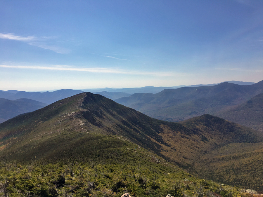
- Next up was the long climb back to 4,000 feet on the Bondcliff Trail, other than one steep burst it's a relatively moderate ascent up to Bondcliff. What made it tougher today was the oppressive heat, I started running into plenty of hikers on my hike up, half were in good spirits and half looked defeated by the heat. The slog and sweat was worth it as the trail breaks above treeline just below the cliffs of Bond, where I enjoyed some of the best above treeline hiking in the White Mountains.
- Views were great as I made the open ridge walk between Bondcliff and Bond, they were a little hazy for this time of year from the mountain heat wave. From Mount Bond I headed towards Guyot, making the short side trip out and back to West Bond to take in some more great views. Guyot, as always, is amazing to hike over, it's a really great spot with sweet views.
- Past Guyot, I reached the Twinway junction where I headed right on the Twinway and over to Zealand Mountain, from here on out I would be back in the woods for the rest of the hike. Along the way I played leap frog with another trail runner who was doing a Zealand-Bonds out and back, it's nice to see other people out enjoying a big day in tough hot weather conditions.
- The only highlight on the way over Zealand and then down to the Zealand Falls Hut is the Zeacliff outlook. It's a great viewpoint, however on this day it was crowded with hikers who had there gear spread out everywhere so I wasn't able to get the usual pictures I like to snap, although I was able to sneak in a decent pano shot.
- As I approached the hut I ran out of water, perfect timing, as I would not have wanted to be without water for more than a short distance considering how hot it was. At the hut I relaxed and prepared my gear for the final climb of the day while chatting with two guys in the midst of a Hut to Hut Traverse, the H2H is one of my favorites so I was a little jealous of them getting to spend the day in the heart of the White Mountains.
- Last but not least, Mount Hale! It's not the most exciting mountain, but the hike up the Lend-A-Hand Trail is nice, and the foliage was very good making it more attractive ascent than usual. I was tired but made decent time up to the summit where I didn't take a break as I was in full let's get home, take the dog out, and stuff my face full of food mode!
- The descent from Hale was via the Hale Brook Trail, it's one of my least favorite trails, mainly because it's a heavily used trail which in recent years has had a problem with hikers crapping right off the side of the trail, tp lingering around, and food wrappers left behind. I'm happy to report that this time this wasn't the case and the trail was free and clear of waste, tp, and trash.
- I made a relatively quick hike down to Zealand Road where I hiked one mile along the road, slightly uphill, back to my Jeep, making it back at 4:55PM. 10 hours 15 minutes after I started.
- I changed out of my clothes, cleaned the mud off of me, and cleaned up the scrapes from the fall I had over flat ground, before making my way back home for 6PM to a very happy to see me Sarge the puppy :)
Leaves changing color quickly along the Zealand Trail
Zealand Pond Swamp
Leaf carpeted A-Z Trail
Beautiful colors through the Birch glades of the A-Z Trail
Hiking up to Mount Tom's summit on the Mount Tom Spur
Pano of Bond, Guyot, Twin Range from Mount Tom
Hiking along the Willey Range Trail over more fallen leaves
View from Mount Field's summit outlooks
Crawford Notch as seen from Mount Willey summit outlook
The famous Willey ladder steps, more are probably needed above and below this because of quick erosion
Willey Range Trail
More picturesque hiking, this time along the Ethan Pond Trail
North Fork crossings, one on the Ethan Pond, and one at Thoreau Falls
The foliage on the Thoreau Falls Trail is beautiful and will be close to peak over the next week
North Fork Pemigewasset River
The Thoreau Falls Trail has a random PUD, filled with a nice pine needle forest and not so nice rotted bog bridges
The final mile walk out over the old railroad grade on the Thoreau Falls Trail
Hiking along the Thoreau Falls Trail
Thoreau Falls bridge
View of the bridge from the middle of the river
It's an rickety old bridge, lots of character!
View of the Bonds from the bridge
Old rotting railroad ties near the end of the Thoreau Falls Trail
Wilderness Trail, leaves are falling here too!
East Branch Pemigewasset River
I crossed here, at the site of the former suspension bridge and railroad trestle. The water was the lowest I have ever seen it!
Troop 64 crossing the bridge back in 1993
Abandoned Wilderness Trail
Black Brook Trestle
The old trail went to the right and crossed a steel footbridge, which has also been removed
Black Brook Trestle
Zoom in of trestle
Hellgate Ravine and its slides
Bondcliff, Bond, West Bond
Left to right; Bemis, Anderson, Nancy, Lowell, Vose Spur, Carrigain, Hancocks
The Hancocks, if you look closely you can see the lines from the skidder roads from the logging era
Hellgate Ravine, Owl's Head, and the Franconia Ridge, (Flume, Liberty, Lincoln, Lafayette)
Bondcliff
Looking out towards the Willey Range with the Presidential Range rising above it
Pano from Mount Bond
Redrock Ravine and South Twin
Bondcliff as seen from West Bond
Franconia Brook Valley
Next up, Mount Guyot
Mount Bond and West Bond from Guyot
Hiking along Mount Guyot, a beautiful spot!
Looking down into the Thoreau Falls (North Fork) Valley
View from Zeacliff outlook. You can see Mount Tom, Field, and Willey on the left
Hiking up Lend-A-Hand Trail
Approaching the summit of Mount Hale
Descending Hale Brook Trail and hiking Zealand Road back to the car
Signs spotted from Zealand Trailhead to the Widlerness Trail
Signs spotted from Bondcliff back to Zealand Road
WOOF squared, that's one happy Goldendoodle puppy!