Date of Hikes: 7/5 & 7/6/15
Long Trail:11.7 miles (3,325 feet elevation gained)
Sunset Ridge Trail: 5.5 miles (2,540 feet elevation gained)
Monroe Trail: 6.5 miles (2,585 feet elevation gained)
Trip Report:
- On Sunday Whitney and I packed up the Jeep and headed to Vermont for two days to hike the remaining four peaks that Whitney had left on the New England 67 highest peak list. Our goal for Sunday was an easy out and back of Abraham and Ellen. The hardest part of the day was probably the steep last few tenths of a mile drive up to Lincoln Gap to the Long Trail parking lot!
- It's a pretty short hike to Mount Abraham, under 2.5 miles and in the woods until the top. There are no steep stretches along this entire route, although there is a significant amount of mud, which is why Whitney refers to the state as Vermud!
- I was in pretty rough shape hiking wise, I was still less than forty-eight hours out from my 46 mile Hut to Hut run and my knee and hip acted up and were aching. I tried to hike as careful as possible to not injure myself.
- Abraham's summit has the best views along this section of the ridge. Unfortunately, it's a very crowded peak so we didn't stay too long on the way through. Just below the summit is a herd path that leads to a crashed cessna plane from 1973. The pilot of the plane was trying to navigate through low visibility and hit the side of the mountain, he lived but a lot of the plane is still laying there in the woods just off the Long Trail.
- From Abraham to Ellen the trail travels along the ridge in the woods with a few gradual up and downs. It passes over Sugarbush ski area and some of the tops of a few lifts. It was a very hazy day so unfortunately we couldn't see the Adirondacks to the west or the Whites to the east but still we had some decent views from the top of the ski slopes and the outlooks along the way. Mount Ellen's summit is just a small cairn in the woods but there is a ski lift just north of it where we took a break,
- From Mount Ellen we retraced our steps back over to Lincoln Gap. We took a break on a nice ledge away from the crowds on Mount Abraham before descending the final couple of mile back to the Jeep. It was an interesting last few miles back to the car, I got extremely sick and Whitney rolled her ankle, ouch squared!
- Once back at the Jeep we drove over to Underhill State Park and spent the night at a campsite. It was such a nice little spot to camp and since it was Sunday it was relatively quiet. We had a fire going and relaxed before calling it a night.
- On Monday we walked from our campsite to the Sunset Ridge Trail. Previously I had hiked Mount Mansfield from the eastern side up the Long Trail, which was pretty steep and not fun until the last scramble section between the 'Chin' and 'Apple'.
- The Sunset Ridge Trail definitely is the way yo go up to the summit, after an easy mile or so hike through the woods the trail climbs up the western exposed arm of the mountain where there are great views all the way up.
- We made it to the summit by 9am and watched the clouds come rolling in and out above and below us. It was pretty quiet on the summit, only a few other hikers around, later on the summit would be a mob scene so it was nice to be up on the summit early in the morning.
- On the descent we originally were going to take the Laura Cowles Trail, but with my knee and hip issue we descended the same way. I didn't mind missing out on the Laura Cowles Trail because it is steep and rugged with no views, where the Sunset Ridge Trail is much more enjoyable descent down the rock slab, plus you have the killer views.
- Once back in the woods we started running into dozens of hikers heading up, we were so happy we beat the crowds and were able to hike up to the summit when it was quiet and peaceful along the trails, another perfectly timed hike for us!
- Next we headed over to the Monroe Trailhead to hike Camel's Hump Mountain for Whitney's finish.
We started around noon and had a pretty easy hike up to the summit. The Monroe Trail is in the woods the whole way and like every other trail we hiked over the past day it has easy to moderate grades and decent footing. Camel's Hump is a bald summit with 360 degree views. There were other hikers up there but it wasn't too crowded and we were able to find a nice spot to sit down and relax for awhile before heading down.
- It was a great peak for Whitney to finish on and she really enjoyed it. I'm happy I got to be there for another hiking goal that she accomplished. Over the past two years I've been lucky enough to hike with here as she finished her first round of the the New Hampshire 48 on Owl's Head, her A.T. thru hike finish on Baxter Peak, and her winter finish on Wildcat A Peak. Pretty impressive hiking she's done over the past two years, you deserve all the praise that goes along with everything you've done, way to go!!!


Between Mount Abraham and Lincoln the Long Trail passes over Lil' Abe!




Long Trail:11.7 miles (3,325 feet elevation gained)
Sunset Ridge Trail: 5.5 miles (2,540 feet elevation gained)
Monroe Trail: 6.5 miles (2,585 feet elevation gained)
Trip Report:
- On Sunday Whitney and I packed up the Jeep and headed to Vermont for two days to hike the remaining four peaks that Whitney had left on the New England 67 highest peak list. Our goal for Sunday was an easy out and back of Abraham and Ellen. The hardest part of the day was probably the steep last few tenths of a mile drive up to Lincoln Gap to the Long Trail parking lot!
- It's a pretty short hike to Mount Abraham, under 2.5 miles and in the woods until the top. There are no steep stretches along this entire route, although there is a significant amount of mud, which is why Whitney refers to the state as Vermud!
- I was in pretty rough shape hiking wise, I was still less than forty-eight hours out from my 46 mile Hut to Hut run and my knee and hip acted up and were aching. I tried to hike as careful as possible to not injure myself.
- Abraham's summit has the best views along this section of the ridge. Unfortunately, it's a very crowded peak so we didn't stay too long on the way through. Just below the summit is a herd path that leads to a crashed cessna plane from 1973. The pilot of the plane was trying to navigate through low visibility and hit the side of the mountain, he lived but a lot of the plane is still laying there in the woods just off the Long Trail.
- From Abraham to Ellen the trail travels along the ridge in the woods with a few gradual up and downs. It passes over Sugarbush ski area and some of the tops of a few lifts. It was a very hazy day so unfortunately we couldn't see the Adirondacks to the west or the Whites to the east but still we had some decent views from the top of the ski slopes and the outlooks along the way. Mount Ellen's summit is just a small cairn in the woods but there is a ski lift just north of it where we took a break,
- From Mount Ellen we retraced our steps back over to Lincoln Gap. We took a break on a nice ledge away from the crowds on Mount Abraham before descending the final couple of mile back to the Jeep. It was an interesting last few miles back to the car, I got extremely sick and Whitney rolled her ankle, ouch squared!
- Once back at the Jeep we drove over to Underhill State Park and spent the night at a campsite. It was such a nice little spot to camp and since it was Sunday it was relatively quiet. We had a fire going and relaxed before calling it a night.
- On Monday we walked from our campsite to the Sunset Ridge Trail. Previously I had hiked Mount Mansfield from the eastern side up the Long Trail, which was pretty steep and not fun until the last scramble section between the 'Chin' and 'Apple'.
- The Sunset Ridge Trail definitely is the way yo go up to the summit, after an easy mile or so hike through the woods the trail climbs up the western exposed arm of the mountain where there are great views all the way up.
- We made it to the summit by 9am and watched the clouds come rolling in and out above and below us. It was pretty quiet on the summit, only a few other hikers around, later on the summit would be a mob scene so it was nice to be up on the summit early in the morning.
- On the descent we originally were going to take the Laura Cowles Trail, but with my knee and hip issue we descended the same way. I didn't mind missing out on the Laura Cowles Trail because it is steep and rugged with no views, where the Sunset Ridge Trail is much more enjoyable descent down the rock slab, plus you have the killer views.
- Once back in the woods we started running into dozens of hikers heading up, we were so happy we beat the crowds and were able to hike up to the summit when it was quiet and peaceful along the trails, another perfectly timed hike for us!
- Next we headed over to the Monroe Trailhead to hike Camel's Hump Mountain for Whitney's finish.
We started around noon and had a pretty easy hike up to the summit. The Monroe Trail is in the woods the whole way and like every other trail we hiked over the past day it has easy to moderate grades and decent footing. Camel's Hump is a bald summit with 360 degree views. There were other hikers up there but it wasn't too crowded and we were able to find a nice spot to sit down and relax for awhile before heading down.
- It was a great peak for Whitney to finish on and she really enjoyed it. I'm happy I got to be there for another hiking goal that she accomplished. Over the past two years I've been lucky enough to hike with here as she finished her first round of the the New Hampshire 48 on Owl's Head, her A.T. thru hike finish on Baxter Peak, and her winter finish on Wildcat A Peak. Pretty impressive hiking she's done over the past two years, you deserve all the praise that goes along with everything you've done, way to go!!!
Heading up the Long Trail from Lincoln Gap
After an easy mile and a half we pass by the Battell Shelter, which sits in a nice hard woods forest just under a mile below the summit
Mount Abraham Summit
Just past the summit of Mount Abraham is the plane crash site from 1973
Between Mount Abraham and Lincoln the Long Trail passes over Lil' Abe!
View from Mount Lincoln, north to Mount Ellen (top). South to Mont Abraham (bottom)
The long Trail passes over the top of the Sugarbush ski area. It makes for some nice views and heads through an area of many different tiny and colorful flowers
The Long Trail along the ridge
Looking down at the ski slopes from one of the outlooks along the way
Holt Hollow is a muddy stretch about a mile before the viewless summit of Mount Ellen
Heading back south along the Long Trail
Signs along the way
Ski area stuff along the way
The colorful flowers that were found along the ski area sections
Early morning on the Sunset Ridge Trail
The Sunset Ridge Trail starts off over nice terrain and stays that way until just before popping out on the ledges
Whitney taking in the views!
Motoring her way up the Sunset Ridge Trail :)
The last mile of the hike up to the summit is over open ledges, definitely the trail to hike up to the top of Mount Mansfield
Views from the top!
Heading back down the Sunset Ridge Trail
Whitney signs us out and we hike back down to Underhill State Park
Signs along the way
The Sunset Ridge Trail is really well maintained and has foot bridges over ever water crossing!
Next up, Camels Hump. Hiking up the Monroe Trail
Congratulations, Whitney AKA Tip-Toe!! :)
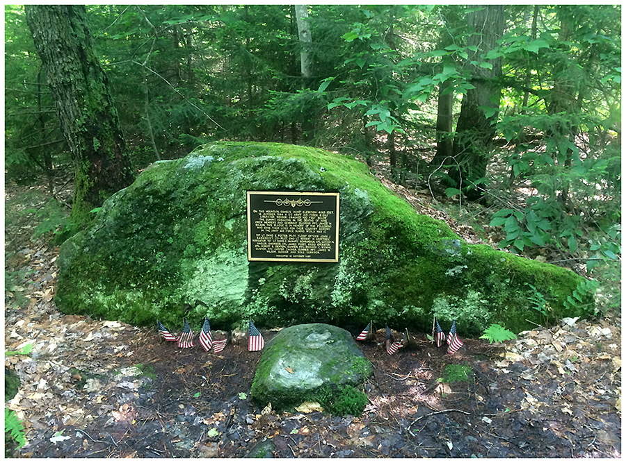
Memorial for the bomber plane that crashed into Camels Hump
Memorial info
Signs spotted along the way
Route for the day, click here for details