
Date of Hike: 7/11/15
Caps Ridge Trail: 1.0 miles / The Link: 1.9 miles / Castle Ravine Trail: 1.0 miles / The Cornice: 0.5 miles / Castle Trail: 0.5 miles / Jefferson Loop Trail: 0.3 miles / Gulfside Trail: 0.6 miles / Sphinx Trail: 2.0 miles / Gulfside Trail: 0.5 miles / The Cornice: 0.5 miles / Caps Ridge Trail: 2.0 miles
Total Miles: 10.7 Miles (5,402 feet elevation gained) Mileage and elevation from STRAVA
Trip Report:
- On Saturday I made a trip over to Jefferson Notch to head up to one of my favorite peaks, Mount Jefferson, before heading over to the Sphinx Trail to do some light trail work.
- My route for the day included a little different route than usual. Most of the time I just head up the Caps Ridge Trail and then head south on the Gulfside Trail to the Sphinx Col, but today I decided to head into the Castle Ravine via The Link, then head up the Castle Ravine, Cornice to the top of the Castle Trail before heading to the Sphinx Col.
- I was pretty surprised at how busy it was at the Caps Ridge trailhead at 8 a.m. The lot was almost full, and there were a lot of Connecticut license plates, maybe it was the Nutmeg state day on Mount Jefferson!
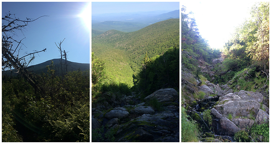
- I passed by several hikers on the first mile up to the trail junction with the Link. From here I wouldn't see another hiker until topping out of the Castle Ravine. The Link for those who are not familiar with it has a reputation as being one of the worst trails in the White Mountains. It begins at Appalachia and ends 7.5 miles later at the Caps Ridge Trail. The trail starts off nice enough but as it approaches the Castle Ravine it becomes filled with roots, rocks, holes, yes holes, and everything is covered in moss. I actually don't mind the trail, it has an enchanted forest feel to it between the Castle Ravine and Castle Trail junctions. Between the Castle and Caps Ridge Trail it is pretty nasty, it's cut like the Parapet Trail except below treeline.
- After hiking along the Link I ascended the Castle Ravine Trail up to the ridge. I have had this trail on my to-do list for years and it did not disappoint. It starts off following closely by the Castle Brook and soon climbs steeply out of the ravine up lose boulders of all sizes. The views become spectacular the higher and steeper the trail gets. It reminded me of a mini version of the King Ravine, just a steep but not as open.
- Once I reached the top of the ravine I hoped on the Cornice over to the Castle and enjoyed the easy grade and above treeline views to the top of the crowded summit.
- From the summit I headed to the Sphinx Trail to do some trail work. My goal for the day was to fix the cairns above treeline, clear any small debris laying in the trail, and take notes on what needs to be done next time through.
- The last two years the trail was in rough shape when I got to it but this year it was in excellent shape! I fixed the cairns above treeline which went quickly, then I dropped down below treeline and at the second brook crossing, where you have to cross over a small cascade, I blocked the herd path to the illegal campsite which had other herd paths running from it down the wrong side of the brook.
- On the rest of my descent down to the floor of the Great Gulf I removed branches, twigs, and other rotting pieces of wood from the trail bed. Finally, I fixed up the last few hundred feet of the trail, the trail isn't well defined and I could tell hikers where stepping off trail for a few yards or so. I put some branches down and cleaned out the trail so if a hiker gets lost on any part of this trail now they should probably just stick to the more popular trails!


Caps Ridge Trail: 1.0 miles / The Link: 1.9 miles / Castle Ravine Trail: 1.0 miles / The Cornice: 0.5 miles / Castle Trail: 0.5 miles / Jefferson Loop Trail: 0.3 miles / Gulfside Trail: 0.6 miles / Sphinx Trail: 2.0 miles / Gulfside Trail: 0.5 miles / The Cornice: 0.5 miles / Caps Ridge Trail: 2.0 miles
Total Miles: 10.7 Miles (5,402 feet elevation gained) Mileage and elevation from STRAVA
Trip Report:
- On Saturday I made a trip over to Jefferson Notch to head up to one of my favorite peaks, Mount Jefferson, before heading over to the Sphinx Trail to do some light trail work.
- My route for the day included a little different route than usual. Most of the time I just head up the Caps Ridge Trail and then head south on the Gulfside Trail to the Sphinx Col, but today I decided to head into the Castle Ravine via The Link, then head up the Castle Ravine, Cornice to the top of the Castle Trail before heading to the Sphinx Col.
- I was pretty surprised at how busy it was at the Caps Ridge trailhead at 8 a.m. The lot was almost full, and there were a lot of Connecticut license plates, maybe it was the Nutmeg state day on Mount Jefferson!
- I passed by several hikers on the first mile up to the trail junction with the Link. From here I wouldn't see another hiker until topping out of the Castle Ravine. The Link for those who are not familiar with it has a reputation as being one of the worst trails in the White Mountains. It begins at Appalachia and ends 7.5 miles later at the Caps Ridge Trail. The trail starts off nice enough but as it approaches the Castle Ravine it becomes filled with roots, rocks, holes, yes holes, and everything is covered in moss. I actually don't mind the trail, it has an enchanted forest feel to it between the Castle Ravine and Castle Trail junctions. Between the Castle and Caps Ridge Trail it is pretty nasty, it's cut like the Parapet Trail except below treeline.
- After hiking along the Link I ascended the Castle Ravine Trail up to the ridge. I have had this trail on my to-do list for years and it did not disappoint. It starts off following closely by the Castle Brook and soon climbs steeply out of the ravine up lose boulders of all sizes. The views become spectacular the higher and steeper the trail gets. It reminded me of a mini version of the King Ravine, just a steep but not as open.
- Once I reached the top of the ravine I hoped on the Cornice over to the Castle and enjoyed the easy grade and above treeline views to the top of the crowded summit.
- From the summit I headed to the Sphinx Trail to do some trail work. My goal for the day was to fix the cairns above treeline, clear any small debris laying in the trail, and take notes on what needs to be done next time through.
- The last two years the trail was in rough shape when I got to it but this year it was in excellent shape! I fixed the cairns above treeline which went quickly, then I dropped down below treeline and at the second brook crossing, where you have to cross over a small cascade, I blocked the herd path to the illegal campsite which had other herd paths running from it down the wrong side of the brook.
- On the rest of my descent down to the floor of the Great Gulf I removed branches, twigs, and other rotting pieces of wood from the trail bed. Finally, I fixed up the last few hundred feet of the trail, the trail isn't well defined and I could tell hikers where stepping off trail for a few yards or so. I put some branches down and cleaned out the trail so if a hiker gets lost on any part of this trail now they should probably just stick to the more popular trails!
The Link between the Caps and the Castle
There is a slide the Link crosses
The link takes on an enchanted forest feel between the Castle and the floor of the ravine
The Castle Ravine Trail travels along the brook for a few tenths of a mile, it crosses a nasty blowdown from Tropical Storm Irene
Heading up the lower end of the Castle Ravine Trail
Looking up from midway up the ravine
The Castellated Ridge and some old orange/redish blazes
Castle Ravine headwall
The Castle Ravine
Topping out of the ravine
Looking north to Mount Adams and the view along the Cornice while heading south
The Cornice
The summit cone of Mount Jefferson along the Castle Trail
Mount Jefferson's summit
Monticello Lawn and Mount Washington
Monticello Lawn
Heading towards Mount Clay and the Sphinx Col
The Sphinx Col
Hiking down the Sphinx Trail, last year I trimmed these sections back and they are holding up well!
Clay Brook cascades
The 'small cascade' water crossing
Irene landslide area
The Sphinx Trail
Along the Sphinx Trail there are still three blue blazes that survived over the years. Since the Sphinx Trail is in a wilderness area all the blazes were removed. The one on the right is barely noticeable but it's there!
I unclogged the rock water bar (top). Passing by and under some wet ledges (bottom)
Above treeline on the Sphinx Trail
Heading back to the Caps Ridge Trail along the Cornice
The Caps Ridge Trail from above the Caps
The Ridge of the Caps
Jefferson Notch - Caps Ridge trailhead
Signs from the Link to the Castle Trail
Signs from the Jefferson Loop to Cornice
Three of my favorite signs
Route for the day
First of all, Chris, thanks ever so much for your trail work, especially for a corridor as remote and challenging as the Sphinx Trail! And secondly (but no less important), you are to be commended for doing such a masterful job of documenting your intense adventures with excellent photography, plus providing a well-written narrative. Bravo!
ReplyDeleteChris,
ReplyDeleteThanks for your trail work. We did a Six Husbands to Jefferson and back on the Sphinx in mid August. On the planning side, the Sphinx was just a convenient exit but it turned out to be just as exciting as Six Husbands. When we reached the crossing in the vicinity of the rogue campsite, we had to look around a bit but we knew the trail did not continue ob that side. Other than that, route finding was trivial, so thanks!
The question I have is, do you think it is possible to reprise this loop in the winter? I've seen trip reports of a winter Six Husbands adventure but seeing the Sphinx trail and that flume-like formation made me wonder what it is like with snow/ice. We'd go equipped but I wonder how practical it really is. I've heard the slope above Jefferson's knee is avalanche prone, so we'd monitor that if it is an issue. Thanks again!
Hi James, glad you guys enjoyed the Sphinx Trail, it really is a steep and fun little trai! As for going in during the winter I have no idea!! I would say during a solid snow year there would be a lot of snow that gets funneled into the the trail most likely leaving a sloping snow drift above flume part. I hope you guys get out there in the winter, if you do let me know how it goes!
DeleteChris, Thanks for your response. We will keep you posted if we go for a winter attempt. Thanks again for the trail work! JIm
Delete