
Date of Hike: 2/21/15
Sawyer River Road: 2.1 miles / Signal Ridge Trail: 9.6 miles / Sawyer River Road: 2.1 miles
Total Miles: 13.7 (4,650 feet elevation gained) Garmin GPS Forerunner 910XT
Total Miles: 13.7 (4,650 feet elevation gained) Garmin GPS Forerunner 910XT
Trip Report:
- Saturday was another below zero day, however, there was low wind out of the southeast and clear skies so I decided it would be a great day to hike the Prince of the Wilderness, Mount Carrigain.
- A little back story on Mount Carrigain's Signal Ridge which I referred to as Burnt Hat Ridge in the trip report title. In the 1870's a group of trampers headed to Carrigain's summit and while up on the ridge the following ensued, "One event of the 1873 hike left a lasting reminder, the name of the ridge just below the summit of Carrigain -- Burnt Hat Ridge. The Portland climbers named it to recall a wind gust that blew Edward Daveis' hat off his head into a fire the group had built. The name has endured." Click here for more information on the whole exploration
- Anyway, back to present day. I arrived at 7am at the end of Sawyer River Road and saw five cars in the lot and thought, yes no trail breaking! While I was getting ready another group of hikers, seven, started arriving. Unfortunately, the first group kept on truckin' past the Signal Ridge trailhead, so 4.5 miles of solo trail breaking laid ahead of me.
- Luckily the first two miles to the old junction with the Carrigain Notch Trail is over relatively flat terrain. When I reached the old junction I decided to hook onto the old trail as I'm not a fan of the Hurricane Irene reroute. This section hadn't seen any travel in quite a while so it was brutal breaking it out but it was only about a quarter of a mile in length so it was worth the challenge.
- After hooking back into the trail it was time to tackle the steep stuff. I usually don't mind trail breaking and steep because it gets you to where you want to go with ASAP, however the Signal Ridge Trail is a different animal. The trail ascends a steep narrow 'ramp' which can get some serious side hill drifting leading to snowshoe slippage off the ramp hindering trail breaking rhythm and momentum. I also do not use poles which hindered my ability to stabilize when going off the ramp.
- Once past the steep narrow section it was onto the switchbacks. This is the part of the trail where you think you're about to gain the ridge but you're never quite there. Eventually you pop out on the eastern section of the exposed ridge and are treated with incredible views down into Carrigain Notch and north to the Presidential Range.
- After the ridge the Signal Ridge Trail dips back down into the woods before winding its way up to the summit. This part had the deepest snow anywhere on the trail, minus the old trail section, and was a real butt-kicker, but I didn't mind since I knew I was only a few minutes from the summit, the tower, and the 360 degree views. The top of the tower was the coldest and windiest part of the hike so I quickly took some pictures before booking it back down and off the summit cone back onto Signal Ridge.
- Eventually I started running into hikers about a quarter to a half mile below the ridge. First was a solo hiker heading up to enjoy the views, followed by the cavalry of seven trudging their way up. Later on below the steep section I ran into Tim C., he was smart getting a late morning start after the stampede had packed down the trail. It was nice catching up with Tim who I always seem to run into or we both notice each others cars at the end of Sawyer River Road when traveling along Route 302.
- After running into Tim I high tailed it back to the road and quickly made my way back to the Jeep. I was still drenched in sweat from breaking trail which was now starting to freeze me up quite a bit. It was nice to get back to the Jeep and warm up before heading on my way. I had hiked Mount Carrigain in the snow in early December over a well broken trail, this time with the trail breaking it took me and hour and ten minutes longer which I was fine with because of the phenomenal views and the killer workout!
Parking lot at the end of Sawyer River Road
The hike to the summer trailhead is an easy two mile walk up the road
Beginning of Signal Ridge Trail and breaking trail along the brook and looking back at my tracks
The Signal Ridge Trail is relatively flat for the first two miles over and old railroad grade
In the winter with the leaves down you can see your destination through the woods
This is where the junction with the Carrigain Notch Trail used to be. The Signal Ridge Trail used to head left here. The Carrigain Notch Trail junction is now further up on the right where the Signal Ridge Trail heads left up and around a beaver pound. I decided to head left here on the old trail.
Small brook crossing on the old trail
Unbroken / Broken
Back on the real trail. It heads through nice open woods for a short distance before . . .
The trail gets steep and drifted. Notice the snow slope which I mentioned int he trip report. Very exhausting stuff!
Heading up to the Signal Ridge
Just before gaining the ridge the trail heads through a dense narrow pine section
Great view down to the Vose Spur and Mount Lowell which make up Carrigain Notch
Vose Spur
Mount Lowell and the 'Chute'
Signal Ridge looking to the summit of Mount Carrigain
Presidential Range to the north
Making it up to the summit tower
Mount Monroe and Washington zoom in
Osceolas
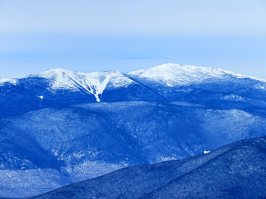
Mount Lincoln and Lafayette
Mount Bond
Bond, Guyot, South Twin
Oakes Gulf with Monroe and Washington
Looking north to Crawford Notch and the Presidential Range
Pemigewasset Wilderness
Looking south to the Hancocks
Signal Ridge
heading back over Signal Ridge
The open face of Signal Ridge
Heading back down over a well packed trail
The old trail is now well packed and cuts about fifteen to twenty minutes off the hike
 Route for the day, click here for more details
Great pictures Chris! One of the great aspects of winter is lack of moisture in the air which enables nice clear pics.
ReplyDeleteThanks, Jim! I agree with the views in the winter, they are crystal clear, and pictures come out more vivid and sharp :)
DeleteThat was me leading up the cavalry of 7. Thanks for breaking out the trail.
ReplyDeleteYou're Welcome, Phil! Thank you to you all for packing it down so well so I could speed down the mountain :)
Deletenice picture, thanks for sharing this kind of write. thanks again
ReplyDeletesee this link