
Date of Hike: 12/30/14
Gale River Road: 1.2 miles / Garfield Trail: 4.6 miles / Garfield Ridge Trail: 3.1 miles / Frost Trail: 1.0 miles / Garfield Ridge Trail: 0.6 miles : Gael River Trail: 4.0 miles / Gale River Road & Route 3: 1.7 miles
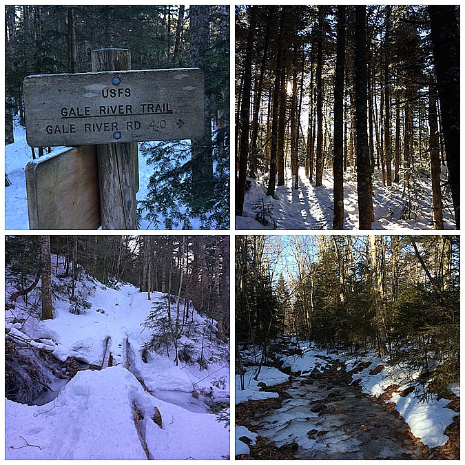
- It was a chilly start but we all kept warm as we set a quick pace along Gale River Road to the summer trailhead. The lower section of the Garfield Trail had minimal snow, bare spots, ice, frozen mud, and water. It was just a messy trail which is so sad considering how much snow coverage there was just two weeks before.
- The Garfield Trail follows and old road that used to give the fire warden access to the summit tower. The grades are easy to moderate which makes the 4.6 mileish hike to gaining the ridge relatively easy. There are a couple of small water crossings which seem to get screwier every year. Today they were just a tad adventurous but not too hard and we all made it across without dunking our boots in.
- There are a handful of long switchbacks along the Garfield Trail which is how the grades stay easy the whole way up tot he ridge. Supposedly there are a few old telephone poles off the side of the trail here and there but I've still not been able to spot them, every time I think I see one it turns out to be an old dead tree, it's turning into my white whale!
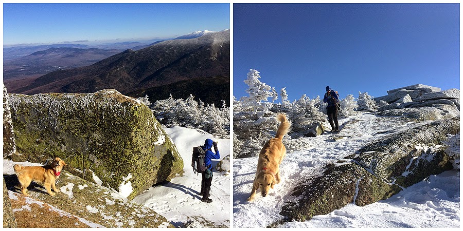
- We didn't stop too many times on the way to the summit because of the temperature but we were holding up well in the sub zero temps. Gryffin did well and didn't seem to mind either but as soon as we reached the open summit we all got knocked back into reality with a cold blast and even Gryffin didn't want to be up there. Thank goodness we didn't do the Z to B Traverse!
- We all quickly headed back to the Garfield / Garfield Ridge Trail junction where Whitney went down ahead of Tim and Kyle so she could make good time and get back before work. I decided to part ways and keep heading along the Garfield Ridge Trail over to to Galehead Mountain.
- The Garfield Ridge Trail is always an adventure, especially in the winter. The trail was packed down nicely to the tent site junction then it became an icy for the steep waterfall section which must have been a blast two weeks ago in the fluffy snow but it was now an ice waterfall. I took to the tree branches and snow on the side of the trail and carefully made my way down the waterfall to solid snow. Over the next few miles to the Galehead Hut the trail was choppy at times with some punching through going on from time to time., wasn't my favorite part of the day but since I've been on this trail dozens of times I knew what to expect.
- I took a nice little break in the sun at the hut and it actually didn't feel too cold...for about five minutes, then it hit me like a ton of bricks so I got going and sped up to Galehead's wooden summit. I kept expecting to run into other hikers but never did, I was lucky enough to have to whole ridge to myself. After Galehead I jetted down the mountain along the Gale River Trail. I had wanted to take the old section of the Gale River Trail on my way out, I'm not a fan of the reroute, it cuts off the two fun water crossings and a nice within ear shot walk near the Gale River. The only plus of the reroute is it crosses Garfield Stream where it is easy to pick up the old trail corridor for the WWII era Gale River trail corridor which takes you up to the secluded Hawthorne Falls. FYI the trail corridor peters out really quickly however, full on bushwhack to the falls.
- The rest of the hike out along the lower end of the Gale River Trail and the Gale River Road went quickly and I was able to stay warm until the last tenth of a mile along Route 3.
- When I got back to the car I changed into dry layers, blasted the heat to high, and headed to North Conway and enjoyed the late afternoon ride along Route 302 where vivid bluebird views of the Presidential Range were to be had driving through Brenton Woods area, not a bad way to end the day!


.jpg)


Gale River Road: 1.2 miles / Garfield Trail: 4.6 miles / Garfield Ridge Trail: 3.1 miles / Frost Trail: 1.0 miles / Garfield Ridge Trail: 0.6 miles : Gael River Trail: 4.0 miles / Gale River Road & Route 3: 1.7 miles
Total Miles: 16.2 (4,350 feet elevation gained)
Trip Report:
- Arctic air has set in over the White Mountains of New Hampshire. Originally, the plan was a Z to B Traverse, short for Zealands - Bonds Traverse for Tim's dog, Gryffin's, 48 - 4,000 footer finish. However, with single digit temperatures at lower elevations and negative temps above 3,000 feet with wind chills hovering around negative twenty we opted for a protected hike. It was decided Mount Garfield was a perfect chilly morning hike, and since it's a relatively easy hike Whitney was able to tag along before heading to work. Also joining in with Whitney, Tim, Gryffin and myself was Kyle D.- It was a chilly start but we all kept warm as we set a quick pace along Gale River Road to the summer trailhead. The lower section of the Garfield Trail had minimal snow, bare spots, ice, frozen mud, and water. It was just a messy trail which is so sad considering how much snow coverage there was just two weeks before.
- The Garfield Trail follows and old road that used to give the fire warden access to the summit tower. The grades are easy to moderate which makes the 4.6 mileish hike to gaining the ridge relatively easy. There are a couple of small water crossings which seem to get screwier every year. Today they were just a tad adventurous but not too hard and we all made it across without dunking our boots in.
- There are a handful of long switchbacks along the Garfield Trail which is how the grades stay easy the whole way up tot he ridge. Supposedly there are a few old telephone poles off the side of the trail here and there but I've still not been able to spot them, every time I think I see one it turns out to be an old dead tree, it's turning into my white whale!
- We didn't stop too many times on the way to the summit because of the temperature but we were holding up well in the sub zero temps. Gryffin did well and didn't seem to mind either but as soon as we reached the open summit we all got knocked back into reality with a cold blast and even Gryffin didn't want to be up there. Thank goodness we didn't do the Z to B Traverse!
- We all quickly headed back to the Garfield / Garfield Ridge Trail junction where Whitney went down ahead of Tim and Kyle so she could make good time and get back before work. I decided to part ways and keep heading along the Garfield Ridge Trail over to to Galehead Mountain.
- The Garfield Ridge Trail is always an adventure, especially in the winter. The trail was packed down nicely to the tent site junction then it became an icy for the steep waterfall section which must have been a blast two weeks ago in the fluffy snow but it was now an ice waterfall. I took to the tree branches and snow on the side of the trail and carefully made my way down the waterfall to solid snow. Over the next few miles to the Galehead Hut the trail was choppy at times with some punching through going on from time to time., wasn't my favorite part of the day but since I've been on this trail dozens of times I knew what to expect.
- I took a nice little break in the sun at the hut and it actually didn't feel too cold...for about five minutes, then it hit me like a ton of bricks so I got going and sped up to Galehead's wooden summit. I kept expecting to run into other hikers but never did, I was lucky enough to have to whole ridge to myself. After Galehead I jetted down the mountain along the Gale River Trail. I had wanted to take the old section of the Gale River Trail on my way out, I'm not a fan of the reroute, it cuts off the two fun water crossings and a nice within ear shot walk near the Gale River. The only plus of the reroute is it crosses Garfield Stream where it is easy to pick up the old trail corridor for the WWII era Gale River trail corridor which takes you up to the secluded Hawthorne Falls. FYI the trail corridor peters out really quickly however, full on bushwhack to the falls.
- The rest of the hike out along the lower end of the Gale River Trail and the Gale River Road went quickly and I was able to stay warm until the last tenth of a mile along Route 3.
- When I got back to the car I changed into dry layers, blasted the heat to high, and headed to North Conway and enjoyed the late afternoon ride along Route 302 where vivid bluebird views of the Presidential Range were to be had driving through Brenton Woods area, not a bad way to end the day!
Gale River Road and the Garfield Trail
Thompson and Spruce brook water crossings
Spruce Brook flash frozen!
Gryffin heads up Garfield!
Along the Garfield Trail
Reaching the summit
Summit foundation and Franconia Ridge
Owl's Head and the Pemigewasset Wilderness
Garfield Ridge trail to Galehead Mountain and the Twins rising high above it
Mount Garfield summit area
Franconia Ridge
Frosted tips!
Along the Garfield Ridge Trail
Garfield Ridge Trail Waterfall
Looking at Galehead Hut and South Twin from the Garfield Ridge Trail
Galehead Hut
Frost Trail to the summit, a small pile of rocks in the woods!
Views from the Frost Trail
Galehead Hut, South Twin, and North Twin
Heading down from Galehead Mountain
Along the Gale River Trail
Garfield Stream and where you can hook onto the WWII era trail corridor for the Gale River Trail
Lower end of the Gale River Trail
The easy road walk back to the car
East and West ends of the Gale River Loop Road
Mount Jefferson, Clay, and Washington in the late afternoon from Route 302
Route for the day, click here for details
No comments:
Post a Comment