
Date of Hike: 10/11/14
Dry River Trail: 9.6 miles / Monroe Loop: 0.7 miles / Crawford Path: 1.8 miles / Eisenhower Loop: 0.8 miles / Crawford Path: 1.2 miles / Webster-Cliff Trail: 0.9 miles / Mount Clinton Trail: 3.0 miles / Dry River Trail: 2.9 miles
Total Miles: 20.9 miles (5,880 feet elevation gained)
Trip Report:
- It had been years since I had been into the Dry River Wilderness. Not since 2010 had I ventured into the remote area, it's not that I haven't wanted to go back but the trails in the Dry River Valley had been closed since Hurricane Irene ripped it to shreds in 2011. Over the past three years the Forest Service has been out there repairing the Dry River Trail as best as they could so they could re-open it to the hiking public.
- I tossed around the idea of a big hike to Whitney and she and her boyfriend Kenny were more than happy to head in there on Saturday for a tour of the Dry River Wilderness.
- The Dry River Trail starts off of Route 302 below Crawford Notch. The first 6.5 miles is relatively flat with some uphill climbing in spots on and off of old logging and railroad grades. It follows the river closely and crosses it over a really kick ass looking suspension bridge just before two miles into the trail.
- After the crossing of the suspension bridge is where the trail took a serious beating in spots. The relocated parts of the trail leave where the RR grades just disappeared into the widened and ravaged Dry River. The relocations all head up embankments and are short, steep, and muddy. It's a good thing the Dry River Trail is lightly used because the relocated sections can barely hold their soil as of right now and will likely erode in spots.
- I can't recall how wide the Dry River was in 2010 but it looks like it might be close to twice the size it once was in spots. The river is a graveyard of decaying tree trunks and jumbled boulders of all sizes. The force of destruction from Irene and Sandy Pants can be seen everywhere in the river from mile zero to around mile five.
- The first 'holy sh!t' moment came when we reached the junction with the Mount Clinton Trail, what a mess! The River wiped out the junction on both sides, there are cairns and flagging heading across the river and up the left banks of the river to help hikers locate the beginning of the trail.
- We took a nice break here before heading further into the valley along more reroutes in some parts until the trail stayed on the old path for good.
- I enjoy hiking with Whitney and Kenny, they both recently completed the A.T. and Kenny finished the Long Trail after the A.T. as well. Their pace is fast which I really like since I can generate heat to keep myself warm throughout a long chilly day. The most impressive site is the ascending by Whitney, which Kenny refers to as 'Whitney Pace'. If I take a picture, just one picture, I have to go into overdrive just to catch up. I absolutely love being pushed physically so I enjoy the sufferfest of catching up!
- The Dry River Trail finally starts to gain elevation after passing the Dry River Shelter #3, which is in great shape and I hope by the time they would want to tear it down like they did with #1 and #2 the rules will be changed and hopefully it will stay there forever. It's a shame as I wonder if anyone who came up with these rules actually have been to this remote lean-to and how low of an impact it has on a huge wilderness area. Yes, there will always be a moron who shits next to the river or burns limbs from trees near it but there's morons in ever walk of life. Stumbling upon a lean-to in bad weather or during an injury can save a life.
- Anyway, after the lean-to we made our way up Oakes Gulf where the views kept getting better and better as we reached treeline. One of the best spots on the trail is the final two tenths of a mile where you crest the ridge and drop down to Lakes of the Clouds Hut, which is closed until next June.
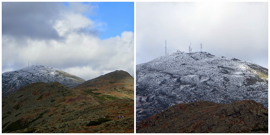
- From the hut we hiked south over Monroe and caught some phenomenal views of a frosted summit cone of Mount Washington to the north.
- Once past Monroe we kept on trucking over Eisenhower and Pierce down to the Mizpah Springs Hut. Originally, we were going to head back down into the Dry River Valley via the Mount Eisenhower Trail but the weather was just too perfect to ditch hiking above the trees. The days of extended above treeline hiking in near perfect weather are dwindling so we took full advantage of it.
- After a nice long break at the hut it was time for the final nice and easy descent back to the Dry River....Wait just a minute, I mean it was time for a three mile descent into hell, two miles of which were an absolute sh!t show. The Mount Clinton Trail after the Dry River Cut-off becomes, narrow and muddy, then become obscure and muddy, then becomes nothingness and muddy. All we had to rely on was the flagging that was located at each water crossing. The trail follows old logging roads in most places. It actually reminded me of the faint RR grade up to Bear Pond in Red Rock Ravine. It was in the exact same condition, meaning not a trail but a faint herd path bushwhack. We initially lost the trail right after a water crossing. I was happy that I was with two strong hikers, so my anxiety didn't start to jump up. I knew if we couldn't get back on trail we could rock hop the brook, no matter how tedious and eventually out to the Dry River to the trail junction. I think I did a pretty decent job of keeping us on the trial proper. After losing it after the crossing we went up an embankment to our right and were back on the logging grade. We lost it again on a side hill where there was a mini blowdown but managed to stay on it as we crossed a tributary which was marked on the map. From here we made another crossing and followed the old grade for awhile, the slope steepened a bit and we lost the trail again. I peaked down the hill to my right at the river and spotted flagging, giddy-up! We trudged downhill and were back on trail. Another few tenths of a mile we made it to the outlet to the Dry River, I kind of figured the trail wrapped around the bend and stayed in the woods over the old grade but I took us out to the Dry River where a few hundred yards downstream Kenny and I spotted flagging. We then rock hopped the river a tenth of a mile, which I actually enjoy and love doing. Eventually we made the crossing, which is wide and would be dangerous in high water.
- Once back on the relatively flat Dry River Trail we high tailed it back to the car and made it out just after sunset. I found out a few days later my friend Mike and Bill ran into the same problems on the Mount Clinton Trail. Also, Ultra-Runner Adam Wilcox ran the same route as us that very day and ran into the same shit show, too. Adam, as always just ran through everything like the speeding bullet!


Dry River Trail: 9.6 miles / Monroe Loop: 0.7 miles / Crawford Path: 1.8 miles / Eisenhower Loop: 0.8 miles / Crawford Path: 1.2 miles / Webster-Cliff Trail: 0.9 miles / Mount Clinton Trail: 3.0 miles / Dry River Trail: 2.9 miles
Total Miles: 20.9 miles (5,880 feet elevation gained)
Trip Report:
- It had been years since I had been into the Dry River Wilderness. Not since 2010 had I ventured into the remote area, it's not that I haven't wanted to go back but the trails in the Dry River Valley had been closed since Hurricane Irene ripped it to shreds in 2011. Over the past three years the Forest Service has been out there repairing the Dry River Trail as best as they could so they could re-open it to the hiking public.
- I tossed around the idea of a big hike to Whitney and she and her boyfriend Kenny were more than happy to head in there on Saturday for a tour of the Dry River Wilderness.
- The Dry River Trail starts off of Route 302 below Crawford Notch. The first 6.5 miles is relatively flat with some uphill climbing in spots on and off of old logging and railroad grades. It follows the river closely and crosses it over a really kick ass looking suspension bridge just before two miles into the trail.
- After the crossing of the suspension bridge is where the trail took a serious beating in spots. The relocated parts of the trail leave where the RR grades just disappeared into the widened and ravaged Dry River. The relocations all head up embankments and are short, steep, and muddy. It's a good thing the Dry River Trail is lightly used because the relocated sections can barely hold their soil as of right now and will likely erode in spots.
- I can't recall how wide the Dry River was in 2010 but it looks like it might be close to twice the size it once was in spots. The river is a graveyard of decaying tree trunks and jumbled boulders of all sizes. The force of destruction from Irene and Sandy Pants can be seen everywhere in the river from mile zero to around mile five.
- The first 'holy sh!t' moment came when we reached the junction with the Mount Clinton Trail, what a mess! The River wiped out the junction on both sides, there are cairns and flagging heading across the river and up the left banks of the river to help hikers locate the beginning of the trail.
- We took a nice break here before heading further into the valley along more reroutes in some parts until the trail stayed on the old path for good.
- I enjoy hiking with Whitney and Kenny, they both recently completed the A.T. and Kenny finished the Long Trail after the A.T. as well. Their pace is fast which I really like since I can generate heat to keep myself warm throughout a long chilly day. The most impressive site is the ascending by Whitney, which Kenny refers to as 'Whitney Pace'. If I take a picture, just one picture, I have to go into overdrive just to catch up. I absolutely love being pushed physically so I enjoy the sufferfest of catching up!
- The Dry River Trail finally starts to gain elevation after passing the Dry River Shelter #3, which is in great shape and I hope by the time they would want to tear it down like they did with #1 and #2 the rules will be changed and hopefully it will stay there forever. It's a shame as I wonder if anyone who came up with these rules actually have been to this remote lean-to and how low of an impact it has on a huge wilderness area. Yes, there will always be a moron who shits next to the river or burns limbs from trees near it but there's morons in ever walk of life. Stumbling upon a lean-to in bad weather or during an injury can save a life.
- Anyway, after the lean-to we made our way up Oakes Gulf where the views kept getting better and better as we reached treeline. One of the best spots on the trail is the final two tenths of a mile where you crest the ridge and drop down to Lakes of the Clouds Hut, which is closed until next June.
- From the hut we hiked south over Monroe and caught some phenomenal views of a frosted summit cone of Mount Washington to the north.
- Once past Monroe we kept on trucking over Eisenhower and Pierce down to the Mizpah Springs Hut. Originally, we were going to head back down into the Dry River Valley via the Mount Eisenhower Trail but the weather was just too perfect to ditch hiking above the trees. The days of extended above treeline hiking in near perfect weather are dwindling so we took full advantage of it.
- After a nice long break at the hut it was time for the final nice and easy descent back to the Dry River....Wait just a minute, I mean it was time for a three mile descent into hell, two miles of which were an absolute sh!t show. The Mount Clinton Trail after the Dry River Cut-off becomes, narrow and muddy, then become obscure and muddy, then becomes nothingness and muddy. All we had to rely on was the flagging that was located at each water crossing. The trail follows old logging roads in most places. It actually reminded me of the faint RR grade up to Bear Pond in Red Rock Ravine. It was in the exact same condition, meaning not a trail but a faint herd path bushwhack. We initially lost the trail right after a water crossing. I was happy that I was with two strong hikers, so my anxiety didn't start to jump up. I knew if we couldn't get back on trail we could rock hop the brook, no matter how tedious and eventually out to the Dry River to the trail junction. I think I did a pretty decent job of keeping us on the trial proper. After losing it after the crossing we went up an embankment to our right and were back on the logging grade. We lost it again on a side hill where there was a mini blowdown but managed to stay on it as we crossed a tributary which was marked on the map. From here we made another crossing and followed the old grade for awhile, the slope steepened a bit and we lost the trail again. I peaked down the hill to my right at the river and spotted flagging, giddy-up! We trudged downhill and were back on trail. Another few tenths of a mile we made it to the outlet to the Dry River, I kind of figured the trail wrapped around the bend and stayed in the woods over the old grade but I took us out to the Dry River where a few hundred yards downstream Kenny and I spotted flagging. We then rock hopped the river a tenth of a mile, which I actually enjoy and love doing. Eventually we made the crossing, which is wide and would be dangerous in high water.
- Once back on the relatively flat Dry River Trail we high tailed it back to the car and made it out just after sunset. I found out a few days later my friend Mike and Bill ran into the same problems on the Mount Clinton Trail. Also, Ultra-Runner Adam Wilcox ran the same route as us that very day and ran into the same shit show, too. Adam, as always just ran through everything like the speeding bullet!
Route for the day, click here for more details
The Dry River Trail
Looking up the foliage filled Oakes Gulf and a frosted Mount Washington
Oakes Gulf Mount Monroe - Washington - The Camel
The Dry River Suspension Bridge
Old Railroad grade, trail relocation, and landslides into the river would be the theme of miles two through five
Destruction in the Dry River
Rock hoping the Dry River and walking through a blowdown section
Dry River Shelter #3 and more sites along the Dry River Trail
Reaching treeline on the Dry River Trail. Kenny spies a glider plane
Gaining the Ridge
The Wilderness Boundary
Lakes of the Clouds
Lakes of the Clouds
Chilly day at Lakes
The 'Dungeon'
Kenny ascending Mount Monroe with the summit cone of Mount Washington rising high above
Mount Washington
Choo Choo descending Jacobs Ladder! The Ridge of the Caps can bee seen in this picture
The Cog
Mount Monroe
View from Mount Monroe
Lakes of the Clouds and Mount Washington
Cross Cairn on the Monroe Loop Trail
Looking back to Mount Washington and Mount Monroe
Washington
Kenny and Whitney head through Franklin Flats
View from Mount Eisenhower
Presidential Range
Brenton Woods
Mount Washington Hotel
Mount Eisenhower
Mount Eisenhower
Mizpah Hut
The Mount Clinton Trail
Mess of blowdowns on the Mount Clinton Trail
Descending the Mount Clinton Trail
Rock hoping to the Dry River
Whitney and Kenny run the river!
Last crossing of the day!
Dry River Suspension Bridge
A look back at where we were throughout the day!
You can hardly see anything at 3.4 mph.
ReplyDeleteHell, when it comes to that Mount Clinton Trail you can hardly see anything if you were crawling down it. So overgrown and mucky!
DeleteWoW!
ReplyDeleteGreat description and stunning pictures. I'm planning a long loop to Jackson and Isolation, it's very helpful to get such a detailed description updating conditions on dry river trail since it reopened. I was hoping to run it while returning to 302 from Isolation but based on this I won't count on keeping a running pace much.
ReplyDeleteSounds like a killer run you have mapped out! Hope you have a great adventure and let me know how it goes. I love hearing about other hikers and runners and the cool routes they come up with!
Deletethese are amazing pics. hoping to join a crew to clear the mt. clinton trail.
ReplyDelete