Showing posts with label Lion Head Trail. Show all posts

Sarge Rock Hops Up & Down the Rock Pile . . . Mount Washington

Date of Hike : 5/24/21

Tuckerman Ravine Trail & Lion Head Trail : 8.6 miles, 4,200' elevation gained

Trip Report:
- As the snow melts away above treeline, I like to take advantage of the abundance of water running on the trails along with the remaining snow fields for an easier accent of Mount Washington for Sarge.  
- We got an early start and saw only a few hikers up Tuckerman Ravine Trail, half were skiers looking to get in a few turns in the bowl. 
- Once on Lion Head Trail we made the steep burst to treeline under abundant sunshine. Luckily temperatures were nice and cool with a slight breeze.
- The remaining snowfields above Lion Head and below the keyhole were half the size they were the previous week but Sarge still took full advantage of running around and eating the snow while drinking up the snow melt along the way.  I give it two more weeks at the most before the snow is completely gone on Lion Head Trail, while snow in the bowl will be around until July.
- Once past the keyhole, Sarge put it in another gear and I had trouble maintaining pace, he'd get ahead and look back down as if to say, "Let's go old man!" 
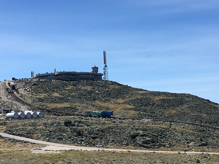
- The summit was really quiet, I only saw a few state park workers as I took the usual summit photo before heading over to the observation deck where Sarge spotted the Cog train chugging up the tracks, which meant time to leave.
- We headed down just as the train made it to the top and jogged back down the mountain seeing about another dozen hikers and a few skiers along the way.
- Towards the bottom we veered off trail so Sarge could take a plunge in what I call the ice box before heading back to Gorham for lunch. :)  

Sarge heads up the wide Tuckerman Ravine Trail then scampers up the ladder steps on Lion Head Trail

Breaking above treeline and taking in the views

Sarge on Lion Head checking out the Bowl

Summit Sarge!

"Daddy, trains coming, can we hitch a ride?"

Sarge observing from the observation deck

New Tucks sign!

Looking out towards Boott Spur

Mount Monroe in the background

Heading back down Lion Head with Wildcat Range in view

Cooling off in the snow

Ice cream treat for lunch!

Ride to the Sky Day on Mount Washington

Date of Hike: 6/15/17

Tuckerman Ravine Trail:  2.4 miles  /  Lion Head Trail: 1.6 miles  /  Tuckerman Ravine Trail: 0.4 miles  /  Nelson Crag Trail: 1.0 miles  /  Alpine Garden Trail: 1.2 miles  /  Tuckerman Ravine Trail: 0.2 miles  /  Lawn Cutoff: 0.4 miles  /  Davis Path: 0.6 miles  /  Boott Spur Trail: 3.4 miles
Total Miles: 11.2 miles (5,077 feet elevation gained) AMC White Mountain Guide Online

Trip Report
- June 15th was Ride to the Sky day on Mount Washington.  The motorcyclists have the auto road all to themselves and head up in droves, vroom vroom!  The weather was perfect so I decided to hike up and check out the bikers driving up.
- With Tuckerman Ravine Trail being closed because of snow on the trail up the headwall, I ascended Lion Head Trail to the upper part of Tuckerman's to the summit.  I started around 10:15AM and made it to the summit at 12PM, enjoying the mid 50's above treeline temperature with light winds  Views were tremendous and it was a great hike up to the rock pile, I counted 57 hikers on my way up, not too bad considering the late start and the "walk in the park" weather.  On the weekend or when summer vacation is in full force and I'd probably triple that number!
- Once at the top I watched the bikers ride up and down, it was very busy at the summit, along with the bikers the Cog Railroad was running three trains at once, but everything seemed very well organized and was not as chaotic as I've seen it during mid-days on normal days.  Hopefully the weather is this good on mini-cooper day so I can check that out too!
- After spending a half hour at the summit I decided to head down Nelson Crag to the Alpine Garden to see the flowers blooming, unfortunately they have still not peeked yet, but it's only a matter of a few days before they do.  There was one kind that was in full bloom, a white flower and they were all over the place, very tiny but very pretty.
- After Alpine Garden I took the Lawn Cutoff over to Davis Path and headed down Boott Spur Trail.  These two trails on perfect weather days should be on your high-priority hike list if you're on Mount Washington.  There is a lot less traffic on both trails and the views are top notch, plus the cairns lining the trail are a thing of beauty.  I saw a total of four people from Lawn Cutoff at Tuckerman Junction to the bottom of Boott Spur Trail, quite a difference from Lion Head Trail!
-  The Boott Spur Trail is pretty rugged and steep, and can beat your body up, but it's worth it for the views.  The below treeline section tends to drag on though, and feels like you're stuck in a time warp, good news is the footing becomes more forgiving near the end.
-  I got back to my Jeep in the early afternoon and made the ten minute drive home, hoping that there will be many more days like this over the summer for quick jaunts up to my favorite mountain :)

Avalanche advisory board at the trailhead

Breaking above treeline on the Lion Head Trail.

Looking at Tuckerman Ravine's headwall from Lion Head

Looking across the ravine at the Boott Spur

The alpine plateau of Lion Head

Lakes of the Clouds and Mount Monroe as seen from the top of the Tuckerman Ravine Trail

Ride to the sky day!

Watching the bikers drive the last mile to the summit from the Observatory

The Cog train and the Northern Presidential Range

Hiking down the Nelson Crag Trail

Looking back up at the observatory

Hiking down from Ball Crag

The top of Huntington Ravine and Wildcat Range across the notch

Looking down at the Alpine Garden

Hiking along the Alpine Garden Trail

I missed the flowers blooming by a few days but it is still always a beautiful spot

The lip of Tuckerman Ravine and the snow that remains

Lawn Cutoff

Mount Washington's summit cone 

Lighthouse cairn on the Davis Path

Washington from Boott Spur

Descending the Boott Spur Trail with a great view of the Wildcat Range

One of the only gradual spots on the Boott Spur Trail

Split Rock

Harvard Rock and Tuckerman Ravine

Ravine of the Raymond Cataract

Tuckerman Ravine

Signs spotted on the way up

Signs spotted at the summit cone

Signs spotted on the way down

Elevation profile for the hike

Huntington Ravine: Following in the Footsteps of Teddy the Golden Retriever

Date of Hike: 5/18/13

Tuckerman Ravine Trail: 1.3 miles 
Huntington Ravine Trail: 2.1 miles  
Alpine Garden: 0.9 miles 
Lion Head Trail: 1.6 miles
Tuckerman Ravine Trail: 2.3 miles
8.2 miles (3,500 elevation gain)

Cutler River

The Fan, Pinnacle, and Central Gully

Huntington Ravine Trail

Pinnacle Gully

The Fan, Pinnacle, and Central Gully

Huntington Ravine Trail

Wildcat Ski Area

Alpine Garden Trail with the Boot Spur in the background

Tuckerman Ravine