
Date of Run: 10/21/17
Baldface Circle Trail: 6.0 miles / Meader Ridge Trail: 2.0 miles / Basin Rim Trail: 1.4 miles / Basin Trail: 2.3 miles / Basin Road: 0.7 miles / Route 113: 0.3 miles / Bickford Brook Trail: 0.7 miles / Blueberry Ridge Trail: 3.0 miles / Bickford Brook Trail: 1.7 miles / Spruce Hill Trail: 1.9 miles / East Royce Trail: 2.0 miles / Royce Connector Trail: 0.2 miles / Royce Trail: 1.4 miles / Basin Rim Trail: 3.9 miles / Mount Meader Trail: 3.0 miles / Route 113: 0.5 miles
Total Miles: 31.0 (10,950 feet elevation gained) AMC White Mountain Guide Online & Guide Book
Trip Report:
- Another Saturday, another unseasonably warm day in the White Mountains. I took advantage of this by heading into Evans Notch and running the 2012 MMD 50K route. On the way to the Baldface Circle trailhead I hid a drop bag in the woods off Basin Road. In hindsight, I should have left another drop bag at the top of the notch as it turned out to be much warmer making this ultra run much more of a grind.
- I started out just before 7:30AM and had the entire Baldface ridgeline to myself, which is a rarity as this is one of the more popular trails in the White Mountains. Even though they are not 4,000 footers, the Baldfaces are a more demanding hike than quite a few of them. The hike up to South Baldface has a steep open slab section with tremendous views, it's quite the grind but well worth the effort.
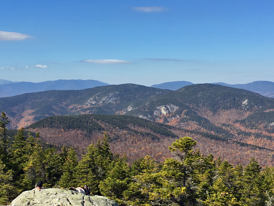
- The peaks of South and North Baldface both have incredible 360 degree views, and the hike along the ridge is spectacular too. Views into the Wild River Wilderness, across to the Carter-Moriah Range with Mount Washington rising above to the west, is what sticks out most to me every time I hike through here.
- Luckily for me the weather was pleasant as I made my way across the ridge, but once I dipped back into the woods the weather started to rise quickly, and by the time I reached Basin Pond it felt like mid-summer. Even with the warm temperatures, I did make great time over the Baldfaces, across Meader Ridge, and down to my drop bag at the entrance to the Basin Recreation Area along Route 113, covering just under 12 miles in just under 3 hours.
- I took a ten minute break to refill my water from my drop bag and then packed the drop bag with my long sleeve shirt, wind breaker, hat and gloves, as it was obvious they weren't needed. Next, I took a short road walk into Maine to the historic Brickett Place, which was a 19th century brick farmhouse.
- The Bickford Trail leaves from the old farmstead, I used this trail and the Blueberry Ridge trail to the summit of Speckled Mountain. It was my first time on these trails and I really enjoyed the views from the ridgeline along the Blueberry Ridge Trail, which were trumped by the excellent views from the summit of Speckled Mountain.
- From the summit of Speckled I made my way over to Evans Notch via the Spruce Hill Trail. It was around this time that I really wished I placed a second drop bag at the East Royce trailhead, as it became clear that I would have to ration my water very carefully to not run out until the final descent about thirteen miles away.
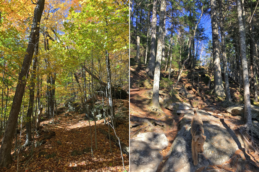
- The run down from Spruce Hill was slower than I would have liked as the trail was filled with leaves, it was beautiful but made for difficult conditions as rocks and roots were buried beneath the leaves. I took my only fall of the day here, resulting in a jammed thumb and a couple of minor scrapes.
- When I reached Evans Notch I was still maintaining a solid pace, around 20 miles in and just over 5 hours. However, I knew from here up to East Royce I was going to get my ass handed to me! It's a steep climb up to East Royce and my pace slowed to a crawl, for a moment I thought my quads might cramp up slightly, a feeling I haven't had since I was chasing my friend Blindt and Darcy up Huntington Ravine in July of 2006 as they were in top shape while training for Mount Rainier!
- It took about 45 minutes to hike the 1.5 miles to the summit, which was well worth the effort as East Royce has a great view. I took a break here to eat, chug the last of my electrolyte drink, and take stock on how much water I had remaining, not much!
- Leaving East Royce I crossed back into New Hampshire and hiked up West Royce, which mercifully was an easier summit push than East Royce, West Royce has switchbacks making the grade easier to deal with. The summit of West Royce is uneventful so I just cruised past it and enjoyed the soft footing and tame up and downs of the Basin Rim Trail to the Rim junction.
- Now, I started my last climb of the day, a moderate to steep 1.5 miles to the Mount Meader Trail junction. Once again I shuffled my way up to the junction slowly, but it was definitely easier than the unforgiving hike up East Royce. Also helping was the fact that I had been on this trail a few times, once earlier in the day descending it, so I knew the ins and outs of it. I also rationed my water perfectly and took my last gulp as I topped out at the junction. With that being said, I should have had a least one more liter of water for this run to keep a more aggressive pace.
- The jog down to Route 113 went well, the first mile has some steep parts with a few perfectly placed swithcbacks, a rarity in the White Mountains. Once past the switchbacks the grades ease and the lower part was surprisingly mostly leaf free making for an quick last mile to the road. Once I reached 113 I walked a half mile back to my car finishing up in 8 hours and 27 minutes.
- What an incredible route this was, definitely more physically demanding than I thought going into it, part of that had to do with the summer temperatures in late October and not having a second drop bag with more water, but mostly it had to do with the steep sections, one sneaky steep half mile at the beginning of the Blueberry Ridge Trail, but especially the steep ass kicker up to East Royce and the encore up to Meader from the Rim Junction.
- What stuck out the most was how the trails were all in great condition, not much erosion, mud, standing water, rotted bog bridges. This made the numerous leave buried sections much easier to deal with and a joy to hike through...for the most part!
- All in all it was another lucky day I got to experience in the White Mountains, filled with views as far as the eye could see!


Baldface Circle Trail: 6.0 miles / Meader Ridge Trail: 2.0 miles / Basin Rim Trail: 1.4 miles / Basin Trail: 2.3 miles / Basin Road: 0.7 miles / Route 113: 0.3 miles / Bickford Brook Trail: 0.7 miles / Blueberry Ridge Trail: 3.0 miles / Bickford Brook Trail: 1.7 miles / Spruce Hill Trail: 1.9 miles / East Royce Trail: 2.0 miles / Royce Connector Trail: 0.2 miles / Royce Trail: 1.4 miles / Basin Rim Trail: 3.9 miles / Mount Meader Trail: 3.0 miles / Route 113: 0.5 miles
Total Miles: 31.0 (10,950 feet elevation gained) AMC White Mountain Guide Online & Guide Book
Trip Report:
- Another Saturday, another unseasonably warm day in the White Mountains. I took advantage of this by heading into Evans Notch and running the 2012 MMD 50K route. On the way to the Baldface Circle trailhead I hid a drop bag in the woods off Basin Road. In hindsight, I should have left another drop bag at the top of the notch as it turned out to be much warmer making this ultra run much more of a grind.
- I started out just before 7:30AM and had the entire Baldface ridgeline to myself, which is a rarity as this is one of the more popular trails in the White Mountains. Even though they are not 4,000 footers, the Baldfaces are a more demanding hike than quite a few of them. The hike up to South Baldface has a steep open slab section with tremendous views, it's quite the grind but well worth the effort.
- The peaks of South and North Baldface both have incredible 360 degree views, and the hike along the ridge is spectacular too. Views into the Wild River Wilderness, across to the Carter-Moriah Range with Mount Washington rising above to the west, is what sticks out most to me every time I hike through here.
- Luckily for me the weather was pleasant as I made my way across the ridge, but once I dipped back into the woods the weather started to rise quickly, and by the time I reached Basin Pond it felt like mid-summer. Even with the warm temperatures, I did make great time over the Baldfaces, across Meader Ridge, and down to my drop bag at the entrance to the Basin Recreation Area along Route 113, covering just under 12 miles in just under 3 hours.
- I took a ten minute break to refill my water from my drop bag and then packed the drop bag with my long sleeve shirt, wind breaker, hat and gloves, as it was obvious they weren't needed. Next, I took a short road walk into Maine to the historic Brickett Place, which was a 19th century brick farmhouse.
- The Bickford Trail leaves from the old farmstead, I used this trail and the Blueberry Ridge trail to the summit of Speckled Mountain. It was my first time on these trails and I really enjoyed the views from the ridgeline along the Blueberry Ridge Trail, which were trumped by the excellent views from the summit of Speckled Mountain.
- From the summit of Speckled I made my way over to Evans Notch via the Spruce Hill Trail. It was around this time that I really wished I placed a second drop bag at the East Royce trailhead, as it became clear that I would have to ration my water very carefully to not run out until the final descent about thirteen miles away.
- The run down from Spruce Hill was slower than I would have liked as the trail was filled with leaves, it was beautiful but made for difficult conditions as rocks and roots were buried beneath the leaves. I took my only fall of the day here, resulting in a jammed thumb and a couple of minor scrapes.
- When I reached Evans Notch I was still maintaining a solid pace, around 20 miles in and just over 5 hours. However, I knew from here up to East Royce I was going to get my ass handed to me! It's a steep climb up to East Royce and my pace slowed to a crawl, for a moment I thought my quads might cramp up slightly, a feeling I haven't had since I was chasing my friend Blindt and Darcy up Huntington Ravine in July of 2006 as they were in top shape while training for Mount Rainier!
- It took about 45 minutes to hike the 1.5 miles to the summit, which was well worth the effort as East Royce has a great view. I took a break here to eat, chug the last of my electrolyte drink, and take stock on how much water I had remaining, not much!
- Leaving East Royce I crossed back into New Hampshire and hiked up West Royce, which mercifully was an easier summit push than East Royce, West Royce has switchbacks making the grade easier to deal with. The summit of West Royce is uneventful so I just cruised past it and enjoyed the soft footing and tame up and downs of the Basin Rim Trail to the Rim junction.
- Now, I started my last climb of the day, a moderate to steep 1.5 miles to the Mount Meader Trail junction. Once again I shuffled my way up to the junction slowly, but it was definitely easier than the unforgiving hike up East Royce. Also helping was the fact that I had been on this trail a few times, once earlier in the day descending it, so I knew the ins and outs of it. I also rationed my water perfectly and took my last gulp as I topped out at the junction. With that being said, I should have had a least one more liter of water for this run to keep a more aggressive pace.
- The jog down to Route 113 went well, the first mile has some steep parts with a few perfectly placed swithcbacks, a rarity in the White Mountains. Once past the switchbacks the grades ease and the lower part was surprisingly mostly leaf free making for an quick last mile to the road. Once I reached 113 I walked a half mile back to my car finishing up in 8 hours and 27 minutes.
- What an incredible route this was, definitely more physically demanding than I thought going into it, part of that had to do with the summer temperatures in late October and not having a second drop bag with more water, but mostly it had to do with the steep sections, one sneaky steep half mile at the beginning of the Blueberry Ridge Trail, but especially the steep ass kicker up to East Royce and the encore up to Meader from the Rim Junction.
- What stuck out the most was how the trails were all in great condition, not much erosion, mud, standing water, rotted bog bridges. This made the numerous leave buried sections much easier to deal with and a joy to hike through...for the most part!
- All in all it was another lucky day I got to experience in the White Mountains, filled with views as far as the eye could see!
Elevation over distance profile
Route for the day
Hiking up the lower section of the Baldface Circle Trail
Baldface lean-to, right before the fun begins!
Hiking up the exposed ledges on the Baldface Circle Trail
As the trail heads up the ledges there are great views to the east
Looking across to North Baldface and Meader Ridge
Above the ledges, Baldface Loop Trail is a beautiful wide open hike
Cairn with a view
Looking west from South Baldface, Mount Washington off in the distance
North Baldface and hiking along the ridgeline
South Baldface as seen from North Baldface
Outstanding views of the Wild River Wilderness and the Carter-Moriah Range
Looking to the north as I make my way towards Meader Ridge
North and South Baldface from Eagle Crag
Meader Ridge and Basin Rim Trail
Basin Pond
Basin Trail
Basin Pond
Pano of Basin Pond
Basin Brook along Route 113
Brickett Place
Route 113 and Brickett Place
Bickford Brook Trail
Blueberry Ridge Trail
View of Basin Rim from one of the ledges along Blueberry Ridge
Beautiful sub alpine walk along the ridge with nice views of Basin Rim to the west and Shell Pond to the southeast
Old fire tower foundations at the summit of Speckled Mountain
The Royces
Bickford Brook Trail
Spruce Hill Trail
Hiking up the East Royce Trail
West Royce as seen from East Royce
Royce Trail on the way to West Royce
Basin Pond
Zoom in of Basin Pond
Mount Meader Trail
The oh so nice footing of the last mile along the Mount Meader Trail
Picture taken from Evans Notch on my drive back home

Trails taken along the way
Signs spotted along Route 113
On Sunday, Sarge and I took a nice easy walk along Pasture Path in Randolph :)


