
July 2nd: Shelburne Moriah & Moriah
Shelburne Trail: 4.0 miles / Kenduskeag Trail: 4.1 miles / Carter-Moriah Trail: 1.6 miles / Stony Brook Trail: 3.6 miles (13.3 miles, 4,200 feet elevation gained)
July 3rd: Mount Washington
Tuckerman Ravine Trail: 4.6 miles / Lion Head Trail: 1.6 miles / Tuckerman Ravine Trail: 2.5 miles (8.7 miles, 4,419 feet elevation gained)
July 16th: Thundersstorm Junction
Airline: 3.2 miles / Chemin Des Dames: 0.4 miles / King Ravine Trail: 0.2 miles / Great Gully Trail: 1.0 miles / Spur Trail: 2.0 miles / Randolph Path: 0.5 / Cliffway: 0.3 miles / Amphibrach: 1.5 miles / The Link: 0.7 miles (9.8 miles, 5,041 feet elevation gained)
Trip Report:
- Quick recap of a couple of stragglers I've procrastinated on writing about over the past few weeks. Whitney is redlining, (hiking all the trails in the A.M.C White Mountain guide) and I tag along, the first and third hikes on this list she was redlining, Shelburne Trail and Great Gully Trail, while the second one was a beat the crowds to the summit of Washington in the morning hike.
- Some highlights, July 2nd, Shelburne Moriah Mountain is a very underrated peak, it doesn't see that much traffic because it's not on the 4,000 footer list and the Appalachian Trail diverges away from it in the Middle Moriah / Shelburne Moriah Col to the west. Views from this summit are pretty spectacular, to the north is the Mahoosuc Range, to the south is the Wild River Wilderness, and to the west is the Moriah-Carter range, plus the Presidential Range. There is a beautiful sub alpine meadow approach to the summit that makes for some great hiking.
- July 3rd, Mount Washington, we wanted to play in the wind on Washington, 55 mph with gusts up to 70mph, wind chill below freezing! We got up early and beat the crowds up Tuckerman Ravine Trail to the summit and had the observatory deck to ourselves and walked through the wind. Whitney was getting blown around pretty good, and it took me a few steps to figure out how to walk through without falling, it was a lot of fun, video is below. On the way down we descended Lion Head Trail and must have seen 150 hikers heading up, most of which had no idea about the conditions above, good luck with that!
- July 16th, Whitney had never hiked the Great Gully Trail, I've done it three times and needed no nudging to hike it a fourth, as I love its remoteness and excessive steepness. To make things a little more interesting we dropped to the floor of King Ravine from Durand Ridge via the Chemin Des Dames, a 0.4 mile stretch of nastiness! Whitney took a couple of slips, including spraining her fingers on the Chemin Des Dames, but toughed it out and continued on up the always adventurous Great Gully!
- Other notes, it has been an extremely wet summer, complete opposite of last year's dry weather, almost every day there is a brief shower or two, and a few times a week there is significant rain. The trails are very slick, muddy and buggy, making for difficult hiking at times, especially descents on steeper and rugged trails. The bugs have been horrible, black flies are still out, deer flies are now out in full force, and mosquitoes await to attack hikers at trailheads. Still, if you study the weather patterns you can squeak in nice hikes above treeline before the storms, or afternoon hikes after they pass on through, which can lead to dramatic views as the clouds clear off or come rolling on in!
Hiking up the Shelburne Trail. The first two miles in along an old logging road / snow mobile Trail
After two miles the Shelburne Trail heads into the woods. Easy grades and good footing until nearing the Howe / Shelburne Moriah Col, then it becomes muddy until the junction
Hiking along the Kenduskeag Trail. Some places there are well place bog bridges, other places are in need of some!
Hiking up to Shelburne Moriah's summit. great views!
Wild River Wilderness
Whitney stops and takes a picture on a sub peak to the east of the summit
Walking along the bog bridges through an alpine meadow
Looking towards Moriah from Shelburne Moriah
Whitney Tip-Toes through a muddy section
Mahoosuc Range
Moriah with the Presidential Range behind it
Signs spotted along the way
---------------------------------------------------------------------------------------------------
Hiking up Tuckerman Ravine Trail
The remaining snow in the bowl!
Looking across the Pinkham Notch from inside Tuckerman Ravine
Windy day on the summit!
Video of wind from the observation deck
Clouds clearing off as we descend
Tuckerman Ravine as seen from Lion Head
Looking back up to the summit cone
Lion Head Trail
---------------------------------------------------------------------------------------------------
 Whitney carefully makes her way down Chemin Des Dames
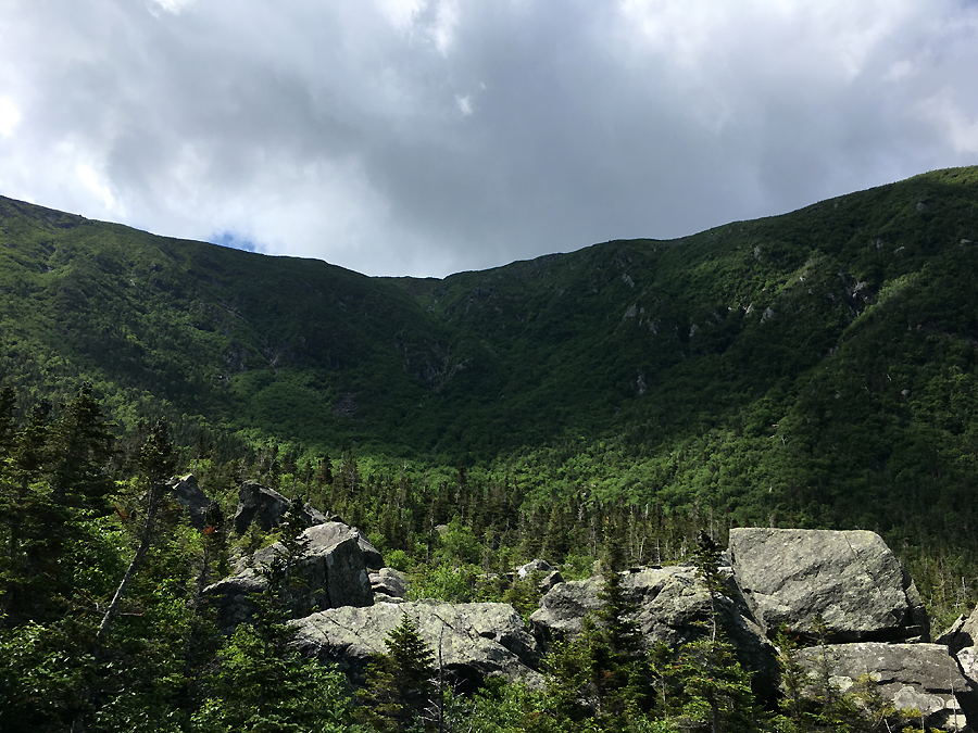
 King Ravine, looking at the Great Gully side
 Whitney heads through the lemon squeezer on the Chemin Des Dames
 Floor of King Ravine
 The Great Gully Trail has a jungle feel to it, a little muddy to overgrown
 Waterfall section of the Great Gully, the trail crosses this twice
 Follow the arrows through the lemon squeezer and up through the scrub!
 Looking down into King Ravine from the top of the trail
 Picture taken from Thunderstorm Junction, where numerous trails converge. If new to the area make sure to study your maps so you know where to go, especially if visibility is low.
 Hiking down the Spur Trail
 Back below treeline passing some mossy brooks along the way
 Signs spotted along the way
---------------------------------------------------------------------------------------------------
WOW!!!!!!!!!!!!!!!!!! NICE!!!!!!!!!! We've been putting off Shelburne Moriah until vacation (or at least 2 days off together). We descended Chemin several years ago when I mixed up the ShortLine/Airline. Thanks for these lovely photos; you've given us a lot to think about for next month. Glad you enjoyed the wind.
ReplyDeleteHave a fun time hiking while on vacation. This week has been dry up here, finally, so hopefully some of the trail will be a little less muddy when you get back up north :)
Delete