Date of Run: 8/10/19
Basin Trail: 2.2 miles / Basin Rim Trail: 1.4 miles / Meader Ridge Trail: 2.0 miles / Eagle Link: 2.7 miles / Wild River Trail: 4.8 miles / Wildcat River Trail: 1.7 miles / Appalachian Trail: 10.9 miles / Kenduskeag Trail: 2.7 miles / Shelburne Trail: 3.2 miles / Wild River Road: 0.6 miles
Total Miles: 32.2 (9,408 feet elevation gained) AMC White Mountain Guide
Trip Report:
- the annual MMD 50K run with a fun group of trail runners took place along some of the most lightly used trails (Eagle Link, Wild River Trail, Shelburne Trail), along with the heavily used Appalachian Trail from Carter Notch past Mount Moriah.
- The weather was nice and cool in the morning with a few showers along Meader Ridge and heading up Carter Dome. The trails were slick so we all used caution, especially for the nasty descent off North Carter which has been the scene of a few bad hiker falls over the years.
- For the first half of the run to Carter Notch Hut I ran with Ben and Hilary, along with Ben's dog Wish. During the second half I ran with Nate and Todd, and Nate's dog Piper.
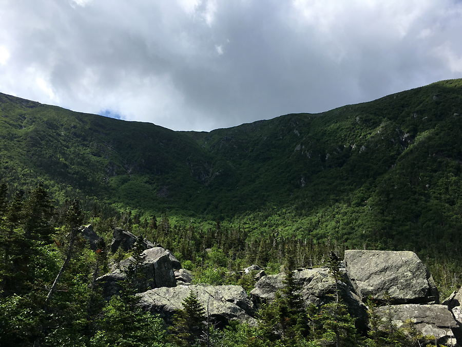
- Some of the highlights of the run; the clouds lifting and staying just above us for some nice views into the Wild River Valley, watching rain showers close in on us from the Presidential Range, the post run BBQ, Kyle meeting me at the finish with Sarge, and waking up the next day with a fun rash on my right leg, most likely Poison Oak, the first time I have ever gotten any rash on or off trail in the Whites!
- For backpackers, hikers or runners, I would definitely suggest checking out the trails branching off from the Wild River. Some of these trails are Eagle Link, which heads up to the Baldfaces / Meader Ridge, between June and late September expect summer growth encroaching the trail. Shelburne Trail which heads to Shelburne Moriah Mountain via Kenduskeag Trail, which is an open summit with tremendous views, much better than 4K Moriah to the south. Moriah Brook Trail, very lightly traveled as you will most likely will not see anyone, it leads up to the Carter-Moriah Trail just over a mile south of Mount Moriah, it can be very muddy and overgrown in spots but still not hard to follow if you pay attention. Black Angel Trail leaving from the Rim Junction this trail heads down and across the Wild River then up to just north of Carter Dome's summit, the trail up to Dome has a very wild feel to it. Wildcat River Trail, the southern terminus of the Wild River Trail, a much quieter and attractive approach to Carter Notch Hut compared to the Nineteen-Mile Brook Trail. Last but not least, Rainbow Trail, this heads up to Carter Dome's summit, traveling through one of the best on trail Birch glades in the White Mountains!


Basin Trail: 2.2 miles / Basin Rim Trail: 1.4 miles / Meader Ridge Trail: 2.0 miles / Eagle Link: 2.7 miles / Wild River Trail: 4.8 miles / Wildcat River Trail: 1.7 miles / Appalachian Trail: 10.9 miles / Kenduskeag Trail: 2.7 miles / Shelburne Trail: 3.2 miles / Wild River Road: 0.6 miles
Total Miles: 32.2 (9,408 feet elevation gained) AMC White Mountain Guide
Trip Report:
- the annual MMD 50K run with a fun group of trail runners took place along some of the most lightly used trails (Eagle Link, Wild River Trail, Shelburne Trail), along with the heavily used Appalachian Trail from Carter Notch past Mount Moriah.
- The weather was nice and cool in the morning with a few showers along Meader Ridge and heading up Carter Dome. The trails were slick so we all used caution, especially for the nasty descent off North Carter which has been the scene of a few bad hiker falls over the years.
- For the first half of the run to Carter Notch Hut I ran with Ben and Hilary, along with Ben's dog Wish. During the second half I ran with Nate and Todd, and Nate's dog Piper.
- Some of the highlights of the run; the clouds lifting and staying just above us for some nice views into the Wild River Valley, watching rain showers close in on us from the Presidential Range, the post run BBQ, Kyle meeting me at the finish with Sarge, and waking up the next day with a fun rash on my right leg, most likely Poison Oak, the first time I have ever gotten any rash on or off trail in the Whites!
- For backpackers, hikers or runners, I would definitely suggest checking out the trails branching off from the Wild River. Some of these trails are Eagle Link, which heads up to the Baldfaces / Meader Ridge, between June and late September expect summer growth encroaching the trail. Shelburne Trail which heads to Shelburne Moriah Mountain via Kenduskeag Trail, which is an open summit with tremendous views, much better than 4K Moriah to the south. Moriah Brook Trail, very lightly traveled as you will most likely will not see anyone, it leads up to the Carter-Moriah Trail just over a mile south of Mount Moriah, it can be very muddy and overgrown in spots but still not hard to follow if you pay attention. Black Angel Trail leaving from the Rim Junction this trail heads down and across the Wild River then up to just north of Carter Dome's summit, the trail up to Dome has a very wild feel to it. Wildcat River Trail, the southern terminus of the Wild River Trail, a much quieter and attractive approach to Carter Notch Hut compared to the Nineteen-Mile Brook Trail. Last but not least, Rainbow Trail, this heads up to Carter Dome's summit, traveling through one of the best on trail Birch glades in the White Mountains!
Map of the route
Elevation profile
Ben and Hilary taking a look over to the Baldfaces
Running Meader Ridge
Eagle Link, it's a jungle in there!
The gang heads up the steep ascent to Carter Dome
Running past the Dome's summit
Taking a break on Mount Hight
Hilary and Nate taking in the views from Hight
Carefully making our way over the slabs along the A.T.
Todd leads the way to Middle Carter
Very well placed but very slick bog bridges
Nate drops in on the nasty descent off North Carter
Piper, Todd, and Nate on Mount Moriah
Piper, his second MMD!
Piper and Todd head up Shelburne Moriah
Leaving Shleburne
We catch up with Justin and cool off in the Wild River
Piper goes for a swim!
Post Run BBQ group pic. In case any of the "old guard" yell at clouds types see this and start to assume a bunch of BS, no we did not run all together ignoring wilderness group size regulations. There were groups of eight that started at 5-6-7AM. which quickly spread out to even less than that. :)
Volunteers did a great job painting the rocks this year for us runners :)
On Monday, Sarge headed into Tucks to take the last turns of the 2018-2019 ski season!
Scoping out a line...about to drop in...
Send it Sarge!!!