
Date of Hike: 8/20/16
Great Gulf Trail: 7.8 miles / Gulfside Trail: 1.1 Trail / Mount Clay Loop: 1.2 miles / Gulfside Trail: 0.7 miles / Mount Jefferson Loop: 0.7 miles / Gulfside Trail: 1.5 miles / Lowe's Path: 0.3 miles / Airline: 0.6 miles / Gulfside Trail: 0.3 miles / Osgood Trail: 1.0 miles / Daniel Webster Scout Trail: 3.5 miles / Dolly Copp Camground & Great Gulf Link: 1.1 miles / Great Gulf Trail: 0.3 miles
Total Miles: 20.1 (8,004 feet elevation gained) AMC White Mountain Guide Online
Trip Report:
- While Huntington Ravine will always be my favorite approach to the summit of Mount Washington, the Great Gulf Trail and more specifically the climb up the headwall from Spaulding Lake is a very close second. The trail runs straight up an excessively steep boulder field, the bottom part through a cascading brook, the middle part through loose talus from a landslide formed by Tropical Storm Irene, and the upper part through ancient boulders as the trail breaches the headwall.
- The hike to Spaulding Lake is long but gradual as it passes by many fine cascades. Once past the Six Husbands Trail and the site of the old Great Gulf Shelter the trail takes on a real remote feeling and also becomes more eroded and wet. At times the trail might be hard to follow, especially at a water crossing right before the Sphinx Trail junction and one flooded section just above Spaulding Lake before popping out above treeline on the headwall.
- The climb up the headwall is the highlight of the hike, the higher you ascend the more phenomenal the views become. Progress up the headwall is slow at best as the footing is tricky navigating through the small cascading brook on the bottom portion. Once past the brook section the footing is slightly better as the boulders are now dry, but the trail is now harder to follow as part of the next section was messed up quite a bit from a landslide in 2011, while there are some cairns the blazes now become non-existent for the next few hundred feet. Once past the landslide section the yellow blazes are back and the trail can be followed with care. My first time on this trail, pre-Irene's landslide, I lost the trail going too far to the left, so if you find yourself not seeing any blazes you're most likely too far over, so keep that in mind.
- Once above the headwall quiet time was over as I headed up to Washington's summit while the Auto Road bike race was going on. I stayed for a half hour, eating lunch while watching bikers finish the last few hundred feet; some where still riding, others were walking next to their bikes, and some were falling over, ouch! It was fun to watch them finish then get in line with their bikes to take a picture by the summit sign.
- From the summit I had to figure out my route back to the Jeep, since the weather was phenomenal I decided to roam north over Presidential Range's summits at an easy pace to make sure I wouldn't re-injure my knee. With my dorky knee brace on and my Ultra Raptors on my feet I felt no pain at all throughout the day, just some general soreness. The Raptors, while not great for speed trail running because of their weight are top notch when it comes to comfort, grip, and protection for hiking.
- The hike across the northern presi's was filled with hundred of happy hikers going every which way, incredibly I only ran into one person I knew, Jim, at Madison Spring Hut.
- Once past the hut I made my way over Madison's summit and down to Osgood Junction where I hooked onto the Daniel Webster Scout Trail and made my way back down below treeline and eventually out to Dolly Copp Campground where I took the Great Gulf Link and back to the Jeep.
- For hikers who are working on their Grid and want to mix things up, or for those who want more seclusion and take the trail less traveled to Washington I encourage you to hike the Great Gulf Trail!
Route for the day
Elevation profile graph
The Great Gulf Trail starts off really nice with good footing and easy grades over the first few miles
Clam Rock, a designated primitive campsite in the Great Gulf Wilderness
Mount Jefferson playing peek-a-boo above the West Branch of the Peabody River
The Great Gulf Trail has a very lush green color to it
Old site of the Great Gulf Shelter, about a quarter mile past the Six Husbands Trail junction. The furthest designated campsite in the Great Gulf Wilderness
Weetamoo Twin Falls
In case you might be unsure the arrow points the way!
Close to the Sphinx Trail junction the trail becomes more eroded and wet
Weetamoo Falls
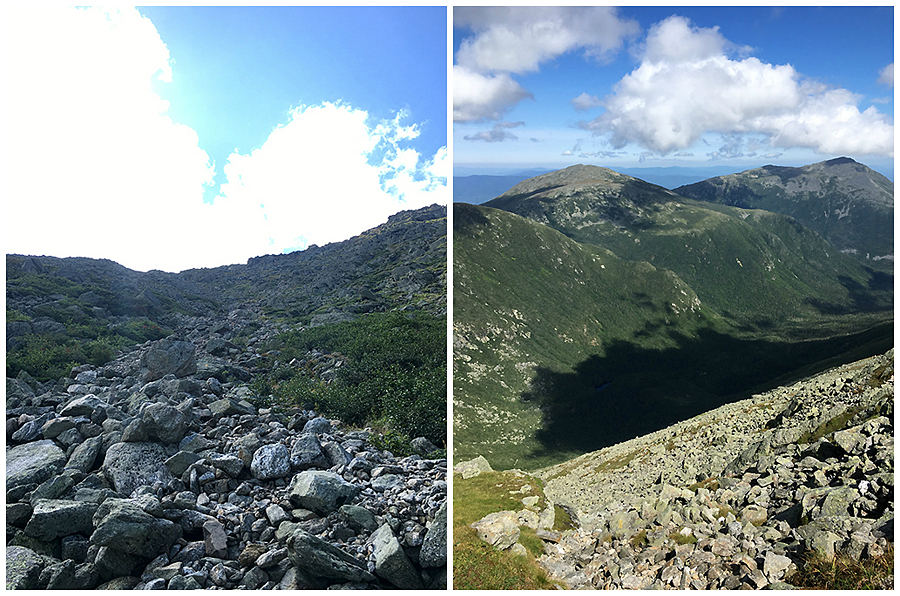
Approaching Spaulding Lake and looking up at the headwall
Spaulding Lake, it's very shallow and quite small
Yup, this is the trail above the lake. For a few hundred yards it's overgrown in parts and flooded in others, just walk through the water, avoid the herd path to the left as you'll just get muddy and wet going that way too!
The cascading brook part of the headwall approach, very refreshing on a hot summer day
Looking up and looking down the headwall, it's steep!
The Great Gulf Wilderness
Looking down from about two thirds up the headwall, back above the slide section where the blazes come back
The final steep approach to the top of the headwall
Mount Jefferson, Adams, and Madison from the Cog Railroad tracks
Heading up to the Observatory
Choo choo!
Bikers finishing up and getting their pic taken at the summit
Feet hanging off the train and taking in the views :)
Along the Mount Clay Loop
On Mount Clay, looking at the true summit (bottom) and then looking at Washington from the true summit (top)
The Great Gulf Headwall. Notice the lighter colored rocks in the middle, that's the slide track from 2011
Next up, Mount Jefferson
Monticello Lawn
Heading up and down the Mount Jefferson Loop
Mount Adams from Jefferson
Dropping down into Edmands Col
Along the Gulfside Trail, heading to Mount Adams (top), looking back to Jefferson, Clay, and Washington (bottom)
Clouds moving in on Thunderstorm Junction
Mount Madison's summit hiding just a tad by the clouds
Durand Ridge and King Ravine
Madison Spring Hut and Mount Madison's summit cone
JQ Adams and Mount Adams from the Osgood Trail
Looking back at Adams from Madison as clouds whisk by
Osgood Ridge
Washington in the clouds and Adams just below them
Looking back up to Madison's summit
Heading to Osgood Junction
The Howks' of Howker Ridge
Great view of the Carter-Moriah Rang (bottom), while clouds start dominating the higher elevations (top)
While the upper half of the Daniel Webster Scout trail is knee hammering rocks the lower part has very forgiving footing
Heading back to the trailhead through Dolly Copp Campground, Great Gulf Link, and back over the Peabody River
Trails taken along the way
Signs and memorials spotted along the way
My dork brace! :)
Dude, your pictures are always great...but this times especially, you captured each scene, sign, boulder, plant and even your brace wonderfully.
ReplyDeleteWhat kind of camera do you use? Please don't say an iPhone. I'm actually in the process of changing over my old point and shoot to my phone because at this point, it's taking better photos...not nearly as nice as what you're publishing.
Karl
Thanks Karl, I was happy the way the pics came out for this hike too!
DeleteFor close up shots without zooming in I use my iPhone 6. When I zoom I use a Cannon Powershot. Sadly the iPhone is now what I use 75% of the time as it takes sharper and more vivid pics.
Saw your report on newenglandtrailconditions.com. Awesome report! Love the photos. I just posted my report, and pics, from my MUCH easier trip over Mt Willey, Field and Tom on Saturday.
ReplyDeleteI'm thinking of doing a similar journey to the one you did (2 night backpacking trip) in October. Thank you for all the details, and trail tips.
Safe hiking.
-Dean
PS. I wear TWO of those braces, one on EACH knee!!
Hi Dean, glad you enjoyed the report and pics, thanks for the kind words :)
DeleteHave a nice backpack in the Great Gulf, plenty of marked primitive tentsites (Bluff, Clam Rock, 0.25 miles past Six Husbands / Wamsutta junction, and usually never anyone in there!
I can't wait to not be wearing the knee brace, don't know how you do it with two on at once!!!
Chris, the tent site is GREATLY appreciated. I will keep you posted if we do the trip or not.
DeleteTwo knee braces is better than not going hiking!
Also, I screwed up on my link to the photos to my last hike. The one I posted to newenglandtrailconditions.com was from my admin page and I can't seem to edit the post. Oh well. However, if you tried to see the post, here's the correct link:
http://www.deancerratiphotography.com/blog/2016/8/the-quest-for-48-continues
And thank you again for the awesome info.
-Dean
Absolutely incredible pictures and great write up! Enjoy your quest for the 48, the best is yet to come :)
Delete