
Date of Hike: 11/15 & 11/16
Livermore Trail: 3.8 / Scaur Ridge Trail: 1.2 miles / Pine Bend Brook Trail: 0.8 miles / Mount Tripyramid Trail: 1.3 miles / Pine Bend Brook Trail: 0.8 miles / Scaur Ridge Trail 1.2 miles / Livermore Trail 3.8 miles
Total Miles: 12.9 miles (3,656 feet elevation gained)
Signal Ridge Trail: 9.4 miles (3,763 feet elevation gained)
Trip Report:
- As I'm working my way to completing the Grid (hiking all 48 - 4,000 footers in every month), I try to keep the hikes interesting by mixing up the trails, running, bushwhacks, slides, old trails, etc. On Sunday I headed up towards Kancamagus Pass and decided to hike the Tripyramids from Livermore Pass via the Livermore and Scaur Ridge trails. I had never hiked the Livermore Trail from the Kanc side so I was really looking forward to heading in from this direction.
- The Livermore Trail begins off Tripoli Road in Waterville Valley and ends at Lily Pond on the Kanc. However, in yesteryear the actual trail was officially called the American Institute of Instruction Path (AKA Livermore Trail). It was Opened in 1879 to replace an old bridle path that connected Waterville at the site of the Waterville Inn (Present day Waterville Valley) to the Sawyer River Station of the Maine Central Railroad in Crawford Notch (present day US 302 at Sawyer River Road. (Information from the 1922 A.M.C Guide to Paths in the White Mountains). Along the way it also passed the Town of Livermore (a town that that was in existence from 1876 - 1951).
- On Sunday I started out around 8:30AM and hiked along an old logging road for just under a mile before dipping into the woods for good. The trail had a dusting of snow in the early morning as I made my way up to the height of land. It was an interesting ascent as I figured the trail would be in decent shape but it was quite eroded in spots up to and just a little past Livermore Pass, which is marked with an old sign nailed high into a tree. Past the pass I made my way over some nasty half frozen mud bogs until Passing Flume Brook and the old Flume Brook Camp where to old forest service road starts. According to the White Mountain Guide pre 1980's, this is where the Livermore Trail officially began as it heads in the direction from where I just came from (towards the Kanc).
- Now that the leaves have fallen there are some really nice obstructed views of the Tripyramids rising high above the woods from the walk along the road. After a mile I banged a left onto the Scaur Ridge Trail which travels up an old logging road for awhile. The grade was easy to moderate and the trail had a good view of the North Slide. It was a real tame hike up to the ridge where I took a right on the Pine Bend Brook Trail and made the easy hike over North and Middle Tripyramid before backtracking.
- On the way back over North Tripyramid I talked about hiking with another hiker who turned out to be Schorman, from the hiking duo Schorman and his main squeeze Lady Di! They both have finished the grid and where out taking advantage of the nice fall weather for a hike in the snow. It was great to run into them and to have a great chat about the mountains with Schorman.
- The hike out went well, the snow was melting fast below 3,000 feet which happens during shoulder season, soon everything will be buried deep under snow but for now the conditions change daily. As I made my way past Livermore Pass I tried find the 'Washington Outlook' described in the old guide books but couldn't find any type of herd path or viewpoint, what i did find was a lot of frozen mud, one of which I stepped shin deep into!
- After the pass I made the descent back down, eventually hooking back onto the old logging road and out to the Kanc where I headed over to North Conway to watch the game where Whitney works.
On Monday I got up really early and hiked Mount Carrigain, another November Grid Peak. I took advantage of the downed leaves to check out a really old abandoned section of the trail I had been spying for a few years. There are three reroutes from the the 2011 tropical storm, (1) is the beginning of the trail, it's been moved to the other side of Whitewall Brook. (2) is about a half mile in, the trail was rerouted up an embankment, the original trail paralleled the brook but it was washed out in two places. (3) is the old Carrigain Notch Trail junction, this has been moved a quarter mile up the trail and involves a PUD, the original trail had some erosion and a pesky water crossing, although no more pesky than most crossings.
- This leads to another reroute which is around 2.25 miles up the trail. I believe it was rerouted in the late 70's but am not quite sure. The trail bangs a sharp left as the old route heads straight up an old logging road above a valley with open woods below. The old section of the trail and the current section are both around a third of a mile long so there's no advantage in taking it but it still was a nice change of pace. Other than one blowdown section the old logging road is very distinguishable and easy to follow.
- As for the hike itself, it was great, I was shielded from the high winds until standing on the summit tower and the views were great.
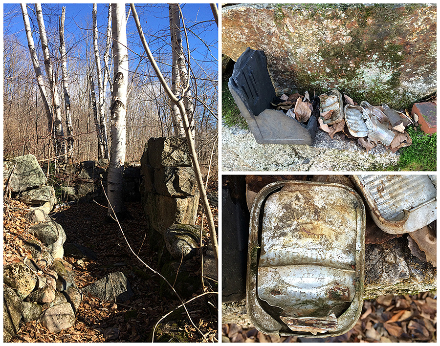
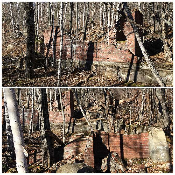
- After the hike I drove back down Sawyer River Road and pulled over to check out the remnants of the town of Livermore. There are some foundations left and a few rock walls overtaken by vegetation but it was an interesting site to walk through. Click on this link for a great overview about the town by Rick Russack, and click here for a very detailed site from the Bartlett Historical Society. I believe I stumbled upon the Brick Power House, which is the most prominent foundation along the road. I also think I might have found the foundation for the schoolhouse, and the Donahue, Goulding and St. George's Hall, but I could be totally wrong.
- At the end of Sawyer River Road at US 302 I think I found the old railroad grade, the brick fireplaces for the depot + engine house, along with the store and office, but again I can't be certain.
- It was really fun to walk through the woods from a town that was around from 1875ish to 1950ish. Not a bad way to start the morning before work!


 Signs spotted along the way


Livermore Trail: 3.8 / Scaur Ridge Trail: 1.2 miles / Pine Bend Brook Trail: 0.8 miles / Mount Tripyramid Trail: 1.3 miles / Pine Bend Brook Trail: 0.8 miles / Scaur Ridge Trail 1.2 miles / Livermore Trail 3.8 miles
Total Miles: 12.9 miles (3,656 feet elevation gained)
Signal Ridge Trail: 9.4 miles (3,763 feet elevation gained)
Trip Report:
- As I'm working my way to completing the Grid (hiking all 48 - 4,000 footers in every month), I try to keep the hikes interesting by mixing up the trails, running, bushwhacks, slides, old trails, etc. On Sunday I headed up towards Kancamagus Pass and decided to hike the Tripyramids from Livermore Pass via the Livermore and Scaur Ridge trails. I had never hiked the Livermore Trail from the Kanc side so I was really looking forward to heading in from this direction.
- The Livermore Trail begins off Tripoli Road in Waterville Valley and ends at Lily Pond on the Kanc. However, in yesteryear the actual trail was officially called the American Institute of Instruction Path (AKA Livermore Trail). It was Opened in 1879 to replace an old bridle path that connected Waterville at the site of the Waterville Inn (Present day Waterville Valley) to the Sawyer River Station of the Maine Central Railroad in Crawford Notch (present day US 302 at Sawyer River Road. (Information from the 1922 A.M.C Guide to Paths in the White Mountains). Along the way it also passed the Town of Livermore (a town that that was in existence from 1876 - 1951).
- On Sunday I started out around 8:30AM and hiked along an old logging road for just under a mile before dipping into the woods for good. The trail had a dusting of snow in the early morning as I made my way up to the height of land. It was an interesting ascent as I figured the trail would be in decent shape but it was quite eroded in spots up to and just a little past Livermore Pass, which is marked with an old sign nailed high into a tree. Past the pass I made my way over some nasty half frozen mud bogs until Passing Flume Brook and the old Flume Brook Camp where to old forest service road starts. According to the White Mountain Guide pre 1980's, this is where the Livermore Trail officially began as it heads in the direction from where I just came from (towards the Kanc).
- Now that the leaves have fallen there are some really nice obstructed views of the Tripyramids rising high above the woods from the walk along the road. After a mile I banged a left onto the Scaur Ridge Trail which travels up an old logging road for awhile. The grade was easy to moderate and the trail had a good view of the North Slide. It was a real tame hike up to the ridge where I took a right on the Pine Bend Brook Trail and made the easy hike over North and Middle Tripyramid before backtracking.
- On the way back over North Tripyramid I talked about hiking with another hiker who turned out to be Schorman, from the hiking duo Schorman and his main squeeze Lady Di! They both have finished the grid and where out taking advantage of the nice fall weather for a hike in the snow. It was great to run into them and to have a great chat about the mountains with Schorman.
- The hike out went well, the snow was melting fast below 3,000 feet which happens during shoulder season, soon everything will be buried deep under snow but for now the conditions change daily. As I made my way past Livermore Pass I tried find the 'Washington Outlook' described in the old guide books but couldn't find any type of herd path or viewpoint, what i did find was a lot of frozen mud, one of which I stepped shin deep into!
- After the pass I made the descent back down, eventually hooking back onto the old logging road and out to the Kanc where I headed over to North Conway to watch the game where Whitney works.
On Monday I got up really early and hiked Mount Carrigain, another November Grid Peak. I took advantage of the downed leaves to check out a really old abandoned section of the trail I had been spying for a few years. There are three reroutes from the the 2011 tropical storm, (1) is the beginning of the trail, it's been moved to the other side of Whitewall Brook. (2) is about a half mile in, the trail was rerouted up an embankment, the original trail paralleled the brook but it was washed out in two places. (3) is the old Carrigain Notch Trail junction, this has been moved a quarter mile up the trail and involves a PUD, the original trail had some erosion and a pesky water crossing, although no more pesky than most crossings.
- This leads to another reroute which is around 2.25 miles up the trail. I believe it was rerouted in the late 70's but am not quite sure. The trail bangs a sharp left as the old route heads straight up an old logging road above a valley with open woods below. The old section of the trail and the current section are both around a third of a mile long so there's no advantage in taking it but it still was a nice change of pace. Other than one blowdown section the old logging road is very distinguishable and easy to follow.
- As for the hike itself, it was great, I was shielded from the high winds until standing on the summit tower and the views were great.
- After the hike I drove back down Sawyer River Road and pulled over to check out the remnants of the town of Livermore. There are some foundations left and a few rock walls overtaken by vegetation but it was an interesting site to walk through. Click on this link for a great overview about the town by Rick Russack, and click here for a very detailed site from the Bartlett Historical Society. I believe I stumbled upon the Brick Power House, which is the most prominent foundation along the road. I also think I might have found the foundation for the schoolhouse, and the Donahue, Goulding and St. George's Hall, but I could be totally wrong.
- At the end of Sawyer River Road at US 302 I think I found the old railroad grade, the brick fireplaces for the depot + engine house, along with the store and office, but again I can't be certain.
- It was really fun to walk through the woods from a town that was around from 1875ish to 1950ish. Not a bad way to start the morning before work!
Leaving the Kanc, the Livermore Trail travels over old logging roads on mostly flat terrain for almost a mile
It turns off the logging road and ascends to Livermore Pass over a more rugged trail at times
As it heads through the pass it becomes a mud bog in places
Site of the old Flume Brook Camp
Flume Brook
After passing Flume Brook the trail opens up and becomes part of the old forest service road
Old Skidder Road Trail junction
Heading down the Livermore Trail it bends around a corner and the Tripyramids come in view
After four miles I hooked onto the Scaur Ridge Trail and head up the moderate grades over an old logging road
View from the North Tripyramid Slide from Scaur Ridge Trail
Heading up the Pine Bend Brook Trail
View from North Tripyramid's summit outlook
Waterville Valley and Mount Tecumsh from Middle Tripyramid's outlook
Photo taken by Schorman. I love this shirt, it's so warm, but I think it's a little too big for me!!
As I head back down the Scaur Ridge Trail the snow starts to vanish from the trail
However, around Livermore Pass there is still some snow left!
Flume Brook
The half frozen trail around Livermore Pass
Livermore Pass
Heading through a bog booby trap and descending back down from the pass
All the snow is now gone from the logging roads on the way out
Heading through an old lumber clearing
The start of the trail from the Kanc
1922 A.M.C Guide's write up of the trail
Route for the day, click here for details
Elevation profile
---------------------------------------------------------------------------------------------------------
Hiking the Signal Ridge Trail, the first two miles is relatively flat
After two miles the trail gets steep and snow starts to cover the trail
Warm days and cold nights = ice!
Above 3,500 feet the trail has a few inches of snow
View of Mount Lowell and Vose Spur from Signal Ridge
Vose Spur and the summit
View from the summit tower of the Pemi Wilderness
Osceola's looking mighty fine in the cool crisp morning air
The sun shining brightly over the Tripyramids
Tom, Field, and Willey
Hancock's (top), looking north to the Presi's blanketed in the clouds
Signal Ridge as seen from the tower's steps
Mount Carrigian's summit tower
An old section of trail, upper relocation about 2.5 miles from the bottom
Old trail goes straight, current trail bangs a left
Old section of the trail about 1.8ish miles from the start
Old water crossing near the old Carrigain Notch Trail junction
Old Carrigian Notch Trail junction
Another old section of the trail. This one had two spots wash into Whitewall Brook
Hard to see but the old trail headed straight, the current trail takes a left and heads up
The final old section of trail I took, this one is the former beginning of the trail over the first few tenths of a mile
The wide 'double crossing' of the Whitewall Brook
Old start of the Signal Ridge Trail off Sawyer River Road. The current trail starts just past the bridge
After my hike I drive back down Sawyer River Road and check out what remains from the old Town of Livermore
I believe this was a school
A few hundred feet down the road I come to another foundation
Then I spot another foundation further down the road
Not much is left, just some old foundations from a few houses
The biggest structure that is left is from an old power house / pumping station
The foundation ran about a few hundred feet
Some of the foundation was in really good shape, just covered with moss
Old power station foundation
Pretty interesting stuff!
The old chimney is half gone and other brick parts have fallen over but look like they haven't fallen in years
At the end of Sawyer River Road I check out a couple of more old structures
Another little odd thing I found
There were two cobble stone fireplaces still in pretty great shape
Looks like an old railroad bed
Route for the day, click here for details. Old trail sections in red
Such a great trip report ! So interesting, the history of the area. Do you know of a book that gives the history of the Livermore area ?? I'd love to do some reading. Great pics, makes me want to get right out there ! Still have the Tripyramids and Carrigain on the list to do. Thanks for taking the time to put together such a great report. - Wendy
ReplyDeleteThanks, Wendy. I haven't searched for a book about the old town but I did stumble upon this link today from the Bartlett Historical Society that has several pages of information that is very interesting!
Deletehttp://www.bartletthistory.org/bartletthistory/livermore.html
http://whitemountainhistory.org/Livermore.html Lots of history - just a mouse click away.
DeleteThat's the link that I posted in my blog post above. I agree, lots of great information!
DeleteDude,. this is an awesome post! I love this area and now even more so. Nicely done :)
ReplyDeleteAndy
Dude,. this is an awesome post! I love this area and now even more so. Nicely done :)
ReplyDeleteAndy
Thanks, Andy! The history that surrounds the trails, notches, and Wilderness areas is very interesting. I'm always learning new facts about the past and am fascinated to stumble upon some of the hidden gems that still remain. :)
Delete