Date of Hikes: 4/9/15 & 4/10/15
Sawyer River Road: 2.0 miles / Signal Ridge Trail: 10.1 miles / Sawyer River Road: 2.0 miles
Total Miles: 14.1 miles (4,476 feet elevation gained)
Rocky Branch Trail: 2.9 miles / Engine Hill Bushwhack: 1.3 miles / Isolation Trail: 1.3 miles / Davis Path: 1.7 miles / Isolation Trail: 2.6 miles / Rocky Branch Trail: 3.7 miles
Total Miles: 13.5 miles (3,703 feet elevation gained)
Trip Report:
- Saturday, Whitney and I headed below the foot of Crawford Notch to the end of Sawyer River Road to hike Mount Carrigain. The forecast was for abundant sunshine, light winds, and temperatures in the mid to high twenties above 4,000 feet.
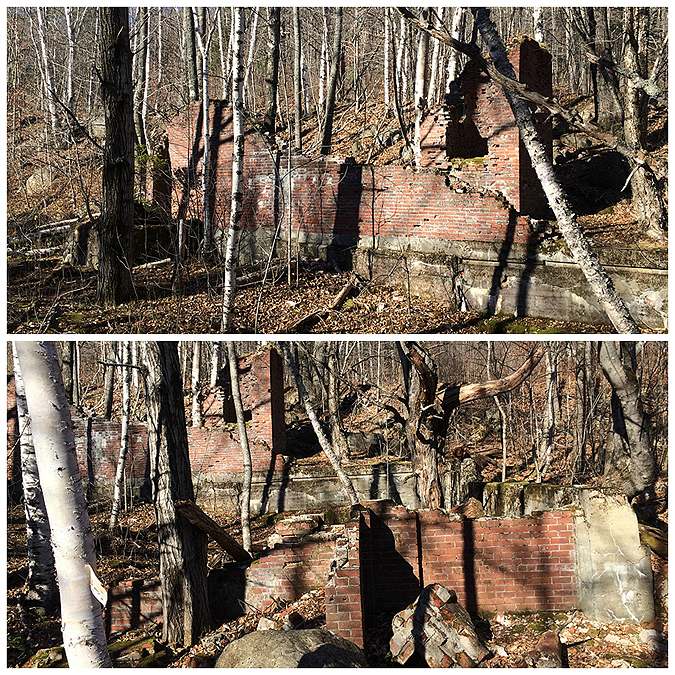
- Sawyer River Road is still closed so we had to road walk two miles to the Signal Ridge Trailhead. It's one of the better road walks as you get to pass by the old town of Livermore and the remaining foundations and old railroad parts from the early to mid twentieth century.
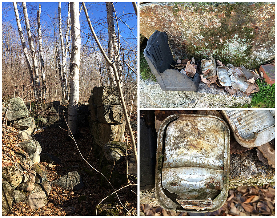
- Once we hooked onto the Signal Ridge Trail we made the gradual climb towards Carrigain Notch for two miles before splitting left at the fork where the old trail use to go. Not being a fan of the new reroute just a little further up trail we stayed on the original cut of the path and made the high but slow current river crossing stepping on submerged rocks with our waterproof trail runners. Soon after hooking back onto the trail proper we stumbled upon an old camp of some sorts that must have been a storage location for the fire warden, or, maybe an old railroad camp. We found some old wire, cans, buckets, shovel, sole of a shoe, and a stove door.
- After checking out the old relics we made our way to the steep part of the trail where it quickly became ice and snow covered, we both put on our microspikes for better traction. Unlike our hike below Sandwich Dome earlier this week we were able to easily, for the most part, make our way up to Signal Ridge where we were greeted with great views.
- Along the ridge we finally ran into a few other hikers with a dog happily making their way down the mountain as we made the final half mile ascent to the summit tower.
- The tower on top of Mount Carrigain has phenomenal views and we could see almost all of the 4,000 footers. The Presidential Range was in the clouds but everything else was free and clear.
- On the way out I tested my crampons with my trail runners while Whitney stayed in her microspikes. The Crampons felt ok on the trail runners but I wouldn't want to wear them for an extended period of time. The good news is, where Whitney had to hug trees on the descent in her microspikes I was able to walk right down for the most part in my crampons.
- Below Signal Ridge we started to come across a few other hikers, a couple who recognized Whitney, one of which owns the Notch Hostel in North Woodstock, (click here for more information). The three girls were hiking with a really friendly Golden Lab who was having a blast!
- After making it through the icy and snowy section on our way down we enjoyed a nice hike out over the lower section of the Signal Ridge Trail, even taking the old trail back out at the very end which drops you out on the road before the bridge. The road walk out was really relaxing as we looked around and spotted old stuff from the railroad and town of Livermore.
- Once back at the car we grabbed some yummy food at the Red Parka before heading back up through the notch.
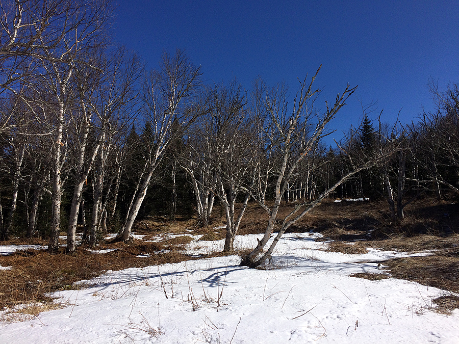
- On Sunday I woke up early and headed to the Rocky Branch trailhead for a quick hike to Mount Isolation. I was expecting to see quite a few hikers out and about but only saw two the whole day. The trail was mostly snow and ice free for the first two miles before it started becoming filled with ice and snow. After three miles, I decided to wander through the Birch glades of Engine Hill, it was the first time I bushwhacked through here when there was basically no snow. I was able to roam around most of the glades before dropping down and coming out on the Isolation Trail where I have in the past. It's definitely a better hike in the dead of winter as the glades are kind of muddy and wet, luckily everything was mostly frozen underneath so I stayed dry. I would really like to walk through here during peak foliage, it must be quite the site.
- Once back on a trail I made my way up to the Davis Path and over to Mount Isolation. It was windy on the summit so I didn't stick around for long but the views were bluebird and spectacular.
- For the hike out I stayed on the Isolation Trail to the Rocky Branch Trail. I had actually never been on the lower end of the Isolation Trail so it was fun to hike it. I enjoyed the water crossing which was a tricky rock hop and I could see some damage from Tropical Storm Irene. When I reached the junction with the Rocky Branch Trail I headed a few hundred feet down trail to check out the site of the old Rocky Branch Shelter #2. All that remains is a charred rectangle of whatever it is they burned down, hundreds of nails, and some junk. Kind of strange, the powers that be tell us about removing man made structures to protect the environment, but then they leave a pile of junk behind, hope they remove it all ASAP because it's an eyesore. Anyway, I'm bummed I never made it back here to see the old shelter before it was taken down.
- After checking out the old site of the shelter I went back up trail, dropped down the river bank and made my last water crossing of the day. The Rocky Branch Trail up to the height of land is a very gradual ascent, the trail is a mixed bag of good footing and roots and half frozen mud pits this time of year. There are some nice open pine woods to the south before making it to the split for the Engine Hill bushwhack, but other than that it's not too exciting.
- Once reaching the height of land I went into cruise control back down to NH 16 finishing around 1:30PM and ending a really great two days of hiking!


Sawyer River Road: 2.0 miles / Signal Ridge Trail: 10.1 miles / Sawyer River Road: 2.0 miles
Total Miles: 14.1 miles (4,476 feet elevation gained)
Rocky Branch Trail: 2.9 miles / Engine Hill Bushwhack: 1.3 miles / Isolation Trail: 1.3 miles / Davis Path: 1.7 miles / Isolation Trail: 2.6 miles / Rocky Branch Trail: 3.7 miles
Total Miles: 13.5 miles (3,703 feet elevation gained)
Trip Report:
- Saturday, Whitney and I headed below the foot of Crawford Notch to the end of Sawyer River Road to hike Mount Carrigain. The forecast was for abundant sunshine, light winds, and temperatures in the mid to high twenties above 4,000 feet.
- Sawyer River Road is still closed so we had to road walk two miles to the Signal Ridge Trailhead. It's one of the better road walks as you get to pass by the old town of Livermore and the remaining foundations and old railroad parts from the early to mid twentieth century.
- Once we hooked onto the Signal Ridge Trail we made the gradual climb towards Carrigain Notch for two miles before splitting left at the fork where the old trail use to go. Not being a fan of the new reroute just a little further up trail we stayed on the original cut of the path and made the high but slow current river crossing stepping on submerged rocks with our waterproof trail runners. Soon after hooking back onto the trail proper we stumbled upon an old camp of some sorts that must have been a storage location for the fire warden, or, maybe an old railroad camp. We found some old wire, cans, buckets, shovel, sole of a shoe, and a stove door.
- After checking out the old relics we made our way to the steep part of the trail where it quickly became ice and snow covered, we both put on our microspikes for better traction. Unlike our hike below Sandwich Dome earlier this week we were able to easily, for the most part, make our way up to Signal Ridge where we were greeted with great views.
- Along the ridge we finally ran into a few other hikers with a dog happily making their way down the mountain as we made the final half mile ascent to the summit tower.
- The tower on top of Mount Carrigain has phenomenal views and we could see almost all of the 4,000 footers. The Presidential Range was in the clouds but everything else was free and clear.
- On the way out I tested my crampons with my trail runners while Whitney stayed in her microspikes. The Crampons felt ok on the trail runners but I wouldn't want to wear them for an extended period of time. The good news is, where Whitney had to hug trees on the descent in her microspikes I was able to walk right down for the most part in my crampons.
- Below Signal Ridge we started to come across a few other hikers, a couple who recognized Whitney, one of which owns the Notch Hostel in North Woodstock, (click here for more information). The three girls were hiking with a really friendly Golden Lab who was having a blast!
- After making it through the icy and snowy section on our way down we enjoyed a nice hike out over the lower section of the Signal Ridge Trail, even taking the old trail back out at the very end which drops you out on the road before the bridge. The road walk out was really relaxing as we looked around and spotted old stuff from the railroad and town of Livermore.
- Once back at the car we grabbed some yummy food at the Red Parka before heading back up through the notch.
- On Sunday I woke up early and headed to the Rocky Branch trailhead for a quick hike to Mount Isolation. I was expecting to see quite a few hikers out and about but only saw two the whole day. The trail was mostly snow and ice free for the first two miles before it started becoming filled with ice and snow. After three miles, I decided to wander through the Birch glades of Engine Hill, it was the first time I bushwhacked through here when there was basically no snow. I was able to roam around most of the glades before dropping down and coming out on the Isolation Trail where I have in the past. It's definitely a better hike in the dead of winter as the glades are kind of muddy and wet, luckily everything was mostly frozen underneath so I stayed dry. I would really like to walk through here during peak foliage, it must be quite the site.
- Once back on a trail I made my way up to the Davis Path and over to Mount Isolation. It was windy on the summit so I didn't stick around for long but the views were bluebird and spectacular.
- For the hike out I stayed on the Isolation Trail to the Rocky Branch Trail. I had actually never been on the lower end of the Isolation Trail so it was fun to hike it. I enjoyed the water crossing which was a tricky rock hop and I could see some damage from Tropical Storm Irene. When I reached the junction with the Rocky Branch Trail I headed a few hundred feet down trail to check out the site of the old Rocky Branch Shelter #2. All that remains is a charred rectangle of whatever it is they burned down, hundreds of nails, and some junk. Kind of strange, the powers that be tell us about removing man made structures to protect the environment, but then they leave a pile of junk behind, hope they remove it all ASAP because it's an eyesore. Anyway, I'm bummed I never made it back here to see the old shelter before it was taken down.
- After checking out the old site of the shelter I went back up trail, dropped down the river bank and made my last water crossing of the day. The Rocky Branch Trail up to the height of land is a very gradual ascent, the trail is a mixed bag of good footing and roots and half frozen mud pits this time of year. There are some nice open pine woods to the south before making it to the split for the Engine Hill bushwhack, but other than that it's not too exciting.
- Once reaching the height of land I went into cruise control back down to NH 16 finishing around 1:30PM and ending a really great two days of hiking!
Lower end of the Signal Ridge Trail was nice and dry...for the most part
Old railroad or fire warden's stuff found just off trail
That's a heck of an ice bulge!
Carrigain Notch
Mount Lowell
Mount Carrigain's summit in view from Signal Ridge
The summit observation tower
Looking down on Signal Ridge
The Pemigewasset Wilderness
Osceola's and Scar Ridge
Hiking along the Signal Ridge Trail
Happy dog!
Whitney makes a new fur buddy :)
Hop, skip, and a jump across the old water crossing
Icy trail on the way out above Whitewall Brook
---------------------------------------------------------------------------------------------------------------------
Heading up the 'top' end of the Rocky Branch Trail
Closing in on the height of land, the trail isn't the most attractive!
The Birch glades of the Engine Hill
Walking though the Engine Hill bushwhack, if you know where to go you can hike through a a few wide open stretches like this
One spot still holing onto snow through the open glades
Rocky Branch uppermost river crossing on the Isolation Trail
An eroded section of the Isolation Trail
A row of 'leaners' before the primitive campsite just below the Davis Path
Summit of Mount Isolation
Boott Spur, Washington, Monroe, Franklin
Mount Washington
Zoom-in of Mount Washington
Heading back out along the Davis Path
First Rocky Branch crossing on the Isolation Trail
Former site of Rocky Branch Shelter #2
Burnt pile of wood, all that is left is nails and some other odd things
Tarp and junk left in the woods
Kind of an eyesore
Rocky Branch crossing located at the junction of the Isolation and Rocky Branch trails