
Date of Hike: 8/29/15
Tuckerman Ravine Trail / Nelson Crag Trail / Old Jackson Road
Total Miles: 10.6 (4,621 feet elevation gained)
Trip Report:
- Mount Washington will always have a special place in my heart. The mountain that beats to a different drum, it's only 6,288 feet above sea level but packs a punch that can snap any hiker back to reality when the weather rapidly deteriorates. I've experienced it all on the mountain over the twenty-seven years I've hiked it; snow, rain, thunder, lightening, fog, clouds, undercast, no visibility, and wind, oh that famous wind!
- On Saturday, I had an easy sunny and low wind day so I decided to go hike the most famous trail up to the rock pile, the Tuckerman Ravine Trail. I made sure to get an early start to beat the crowds up to the summit, as on a sunny weekend day in the summer there are hundreds of people who hike up this trail.
- The trail starts at the Pinkham Notch Visitor Center and easily travels two miles to Hermit Lake Shelter over a very wide access road. I passed by about two dozen hikers as I made my way past Hermit Lakes and then to the floor of the ravine. From here I only saw a handful of hikers and was able to hike up the trail in relative quietness with only the water falling from the headwall as birds chirped as they flew around the ravine.
- Hiking up next to the headwall is a great experience, the massive rock wall is quite the site to hike by, next to, and then above as water splashes down over the rocks from water that gushes out of the earth. While the trail is relatively easy, it's one of the few places where stepping off trail can have grave consequences. Unfortunately, every few summers a hiker will try and hike off trail toward the waterfalls and slip and fall to their death. The trail has been cut into the side of the ravine and even stepping off a few feet to thew left or right in spots can result in a serious injury or worse.
- After topping out above the headwall I made my way to the top over the boulder field that makes up the summit cone of Washington. I made it to the summit around 9:30 a.m. and there were hardly anyone else up there. I even had the summit sign to myself for a few minutes, which was really nice since it marked the fiftieth time I had summited Mount Washington. From the summit I went onto the observation deck and watched the last of the remaining clouds blow off the Northern Presidential Range.
- After taking in the views I took a nice break in the cafeteria and chatted with two guys who road their motorcycles to the summit. They asked me a bunch of questions about hiking and seemed really pumped to get out and try hiking Mount Washington in the near future.
- After eating some food I wandered around the summit a little longer, I headed into the Tip-Top House, went back to the summit sign, took in more views from the observation deck as a couple of the Cog Railroad trains came chugging up the tracks.
- Once the trains come up quiet time on the summit cone disappears and the the rock pile takes on a circus type atmosphere. This was my Q to leave, I have nothing against the swarms of people on the summit, I think it's really great that people get up here, plus I know where to go if I need to avoid the summit crowds, I just was enjoying the peace and quiet of the morning so I moseyed on down the Nelson Crag Trail.
- Within minutes of starting my decent I took another small detour to explore, this time it was just past the road crossing where I spotted and old concrete / boulder foundation and some iron rungs. I want to say this was part of an old military facility / testing hanger but I'm not quite sure as I couldn't find any information online and forgot where I had read about it in the past.
- After exploring I descended down the long exposed ridge the Nelson Crag Trail travels along. I had only descended the trail once before and had forgotten had beautiful the views were while descending. It stays above treeline for a long time before dropping down into the woods and probably has the best views of the Wildcat-Carter Range around. The other cool thing is it descends near the auto road so you get to watch the cars go up and down and see how many of them over heat!
- Once back below treeline I made quick work down to Old Jackson Road and back over to the Jeep in Pinkham Notch.
- It was a really nice morning hiking Mount Washington, I couldn't have asked for a better day for my fiftieth time hiking up the old rock pile. :)
 Heading up the nice wide Tuckerman Ravine Trail. The first few miles are basically over an access road with easy grades
 Heading to Hermit Lake Shelter
 The ranger station at Hermit Lake
 Tuckerman Ravine!
 Past Hermit Lake the trail becomes more what I am accustomed to, rugged-knee hammering rocks
 'The Bowl'
 The Headwall
 Pressure from inside the earth creates year round waterfalls
 Heading up the headwall
 Skirting along the trail to the top of the headwall
 Looking back down into Tuckerman Ravine
 Mount Monroe from the shoulder of Mount Washington
 Summit sign on the rock pile
 50th time on Washington, almost 27 years to the day after my first time :)
 Northern Presidential Range
 Summit info sign, observation deck, cafeteria
 Tip Top House
 Old photo displaying building from the early twentieth century
 Funny old drawing of Abe Crawford and others wrestling bears!
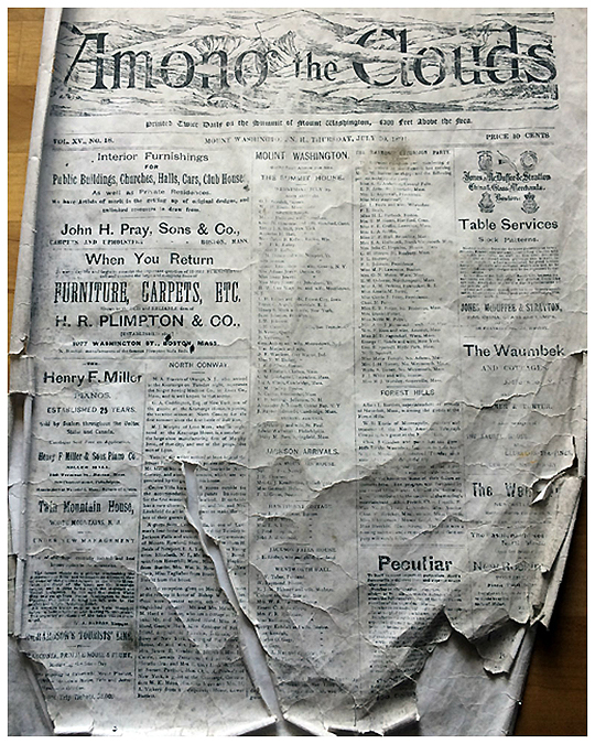 Among the Clouds was a newspaper publication printed from the summit
 Old stove and kitchen space
 All the neat stuff that is in the Tip Top House
 The summit area
 The Cog train and the Lizzie Bourne Memorial. She was one of the first people to perish on the mountain, just a few yards away from the summit
 The Auto Road and the observatory
 Old foundation mixed in with boulders just off the auto road
 Looking back at the area where the foundation was. There is a rectangular shape visible which is what the building covered
 Hiking down the Nelson Crag Trail. It's a long stretch of beautiful above treeline hiking
 Heading down and looking back up towards the summit
 The Mount Washington Auto Road. The Nelson Crag Trail skirts along the road at a bend but never crosses it
 Great day to hike above treeline
 Wildcat Range and ski area
 Back in the woods on the Nelson Crag Trail and Old Jackson Road
 Signs spotted along the way to the floor of the ravine
 Signs spotted above the headwall and back to PNVC
 Route for the day, click here for details
Tuckerman Ravine Trail / Nelson Crag Trail / Old Jackson Road
Total Miles: 10.6 (4,621 feet elevation gained)
Trip Report:
- Mount Washington will always have a special place in my heart. The mountain that beats to a different drum, it's only 6,288 feet above sea level but packs a punch that can snap any hiker back to reality when the weather rapidly deteriorates. I've experienced it all on the mountain over the twenty-seven years I've hiked it; snow, rain, thunder, lightening, fog, clouds, undercast, no visibility, and wind, oh that famous wind!
- On Saturday, I had an easy sunny and low wind day so I decided to go hike the most famous trail up to the rock pile, the Tuckerman Ravine Trail. I made sure to get an early start to beat the crowds up to the summit, as on a sunny weekend day in the summer there are hundreds of people who hike up this trail.
- The trail starts at the Pinkham Notch Visitor Center and easily travels two miles to Hermit Lake Shelter over a very wide access road. I passed by about two dozen hikers as I made my way past Hermit Lakes and then to the floor of the ravine. From here I only saw a handful of hikers and was able to hike up the trail in relative quietness with only the water falling from the headwall as birds chirped as they flew around the ravine.
- Hiking up next to the headwall is a great experience, the massive rock wall is quite the site to hike by, next to, and then above as water splashes down over the rocks from water that gushes out of the earth. While the trail is relatively easy, it's one of the few places where stepping off trail can have grave consequences. Unfortunately, every few summers a hiker will try and hike off trail toward the waterfalls and slip and fall to their death. The trail has been cut into the side of the ravine and even stepping off a few feet to thew left or right in spots can result in a serious injury or worse.
- After topping out above the headwall I made my way to the top over the boulder field that makes up the summit cone of Washington. I made it to the summit around 9:30 a.m. and there were hardly anyone else up there. I even had the summit sign to myself for a few minutes, which was really nice since it marked the fiftieth time I had summited Mount Washington. From the summit I went onto the observation deck and watched the last of the remaining clouds blow off the Northern Presidential Range.
- After taking in the views I took a nice break in the cafeteria and chatted with two guys who road their motorcycles to the summit. They asked me a bunch of questions about hiking and seemed really pumped to get out and try hiking Mount Washington in the near future.
- After eating some food I wandered around the summit a little longer, I headed into the Tip-Top House, went back to the summit sign, took in more views from the observation deck as a couple of the Cog Railroad trains came chugging up the tracks.
- Once the trains come up quiet time on the summit cone disappears and the the rock pile takes on a circus type atmosphere. This was my Q to leave, I have nothing against the swarms of people on the summit, I think it's really great that people get up here, plus I know where to go if I need to avoid the summit crowds, I just was enjoying the peace and quiet of the morning so I moseyed on down the Nelson Crag Trail.
- Within minutes of starting my decent I took another small detour to explore, this time it was just past the road crossing where I spotted and old concrete / boulder foundation and some iron rungs. I want to say this was part of an old military facility / testing hanger but I'm not quite sure as I couldn't find any information online and forgot where I had read about it in the past.
- After exploring I descended down the long exposed ridge the Nelson Crag Trail travels along. I had only descended the trail once before and had forgotten had beautiful the views were while descending. It stays above treeline for a long time before dropping down into the woods and probably has the best views of the Wildcat-Carter Range around. The other cool thing is it descends near the auto road so you get to watch the cars go up and down and see how many of them over heat!
- Once back below treeline I made quick work down to Old Jackson Road and back over to the Jeep in Pinkham Notch.
- It was a really nice morning hiking Mount Washington, I couldn't have asked for a better day for my fiftieth time hiking up the old rock pile. :)
#50! That's awesome! You're right about it packing a punch. When I was in my best hiking shape, that mountain still killed me. Great job on illustrating your journey through the pictures!
ReplyDeleteBTW - Off topic, are you tracking your redlining in the Whites?
Thanks,
Karl
Hi Karl!
DeleteI'm have not started tracking my red-lines yet. I'll probably end up doing what I did with the Grid, fill it out in a few years and if I'm around 70% I'll start hiking new trails. Whitney is red-lining so I'm sure I'll hike a bunch of new trail miles with her over the next few years as she completes it :)