Date of Hike: 8/30/17
Old Jackson Road: 1.8 miles / Nelson Crag Trail: 3.6 miles / Gulfside Trail: 0.9 miles / Westside Trail: 0.9 miles / Davis Path: 0.4 miles / Tux X-Over: 0.8 miles / Crawford Path: 0.8 miles / Mount Monroe Loop: 0.7 miles / Crawford Path: 1.6 miles / Tuckerman Ravine Trail: 4.3 miles
Total Miles: 15.8 (6,736 feet elevation gained) A.M.C. White Mountain Guide Online
Trip Report
- Wednesday, I had some free time to sneak in a hike before having to be back home for noon. I woke up early and headed to Pinkham Notch to quick hike Mount Washington and Mount Monroe. I decided to ascend Washington via Old Jackson Road and Nelson Crag Trail. Old Jackson Road is an easy hike with easy grades, it's not too exciting but it goes by quick until the real hiking begins on the Nelson Crag Trail. The trail is rough and steep to treeline, it's a real butt-kicker, but it's worth it as the views are great once above treeline. The trail is also less traveled, so even in the summer you're not likely to see many hikers. It does go by the auto road at Cragway Spring, so there will be some commotion there, but overall it's mostly a quiet hike up the Crags. Since I was on the trail at 6:40AM, there were only a few Auto Road workers on the road when I passed by just before 8AM.
- I reached the summit just before 9AM, I had the summit sign all to myself and took a five minute break sitting underneath it while eating a snack before continuing on. It's not very often you can lounge around the summit sign undisturbed for as long as you please, so it was a pretty cool moment.
- Next I continued on, taking a less than direct route to Mount Monroe via Gulfside, Westside, Davis Path, Tuckerman Crossover, Crawford Path around Mount Monroe, then Mount Monroe Loop over the summit from the south. It was a fun and different way of dropping down to Monroe.
- From Monroe's summit I headed down to Lakes of the Clouds and then back up to Mount Washington's summit arriving back on top at 10:42AM. This time there were hikers and tourists out and about, but it was still relatively quiet, there was one couple taking a picture at the summit sign, so I went back up again and enjoyed a moment alone at the sign after they left.
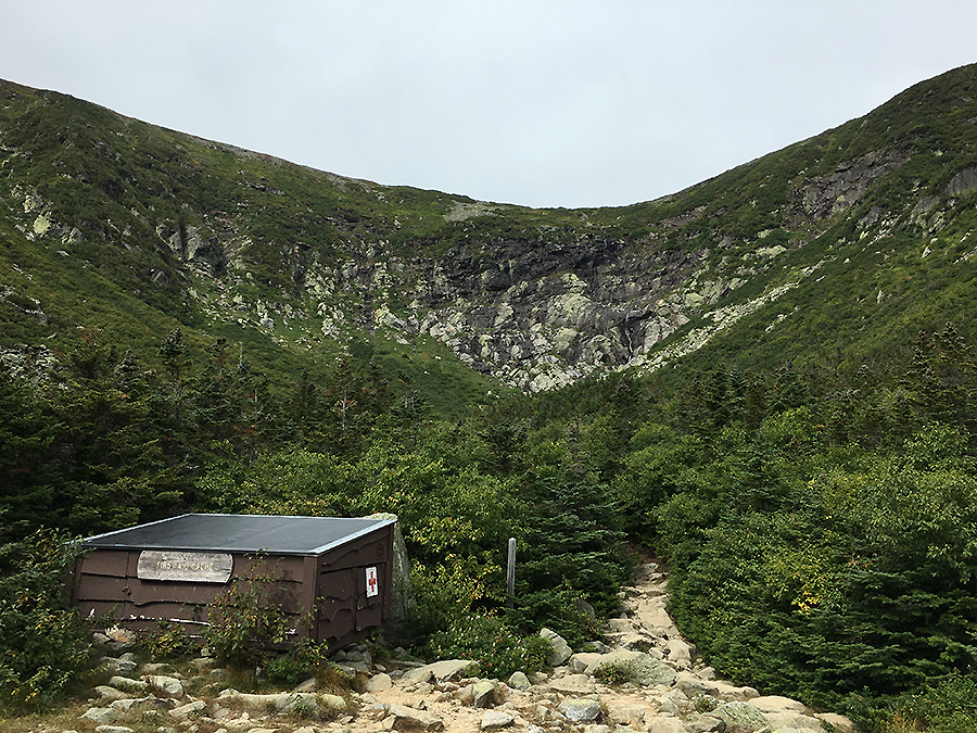
- Now it was time to head back home, since I wanted to be back for noon, I "ran" down the Tuckerman Ravine Trail. For the most part, the trail is not runnable until passing by the first aid cache at the floor of the ravine, so pace is determined on rock-hopping, where you have to be very careful to pick and choose boulders, not smaller rocks that move, to "tap dance" down. From the first aid cache the trail can be trail run at a decent pace, keeping in mind to be courteous to hikers and not running up on or into them.
- Since conditions were favorable, (dry rocks) it was a quick "run" down to PNVC, making it to my jeep in fifty minutes, and then making the ten minute drive back home, arriving a few minutes before noon. It was the second straight year I was able to hike Mount Washington on the anniversary of my first hike of the rock pile back in 1988, hopefully I can make this an annual occurrence since moving up to the White Mountains in November of 2105. I am very lucky to have been able to spend an absurd amount of time on this mountain, something I am always grateful for. :)


Old Jackson Road: 1.8 miles / Nelson Crag Trail: 3.6 miles / Gulfside Trail: 0.9 miles / Westside Trail: 0.9 miles / Davis Path: 0.4 miles / Tux X-Over: 0.8 miles / Crawford Path: 0.8 miles / Mount Monroe Loop: 0.7 miles / Crawford Path: 1.6 miles / Tuckerman Ravine Trail: 4.3 miles
Total Miles: 15.8 (6,736 feet elevation gained) A.M.C. White Mountain Guide Online
Trip Report
- Wednesday, I had some free time to sneak in a hike before having to be back home for noon. I woke up early and headed to Pinkham Notch to quick hike Mount Washington and Mount Monroe. I decided to ascend Washington via Old Jackson Road and Nelson Crag Trail. Old Jackson Road is an easy hike with easy grades, it's not too exciting but it goes by quick until the real hiking begins on the Nelson Crag Trail. The trail is rough and steep to treeline, it's a real butt-kicker, but it's worth it as the views are great once above treeline. The trail is also less traveled, so even in the summer you're not likely to see many hikers. It does go by the auto road at Cragway Spring, so there will be some commotion there, but overall it's mostly a quiet hike up the Crags. Since I was on the trail at 6:40AM, there were only a few Auto Road workers on the road when I passed by just before 8AM.
- I reached the summit just before 9AM, I had the summit sign all to myself and took a five minute break sitting underneath it while eating a snack before continuing on. It's not very often you can lounge around the summit sign undisturbed for as long as you please, so it was a pretty cool moment.
- Next I continued on, taking a less than direct route to Mount Monroe via Gulfside, Westside, Davis Path, Tuckerman Crossover, Crawford Path around Mount Monroe, then Mount Monroe Loop over the summit from the south. It was a fun and different way of dropping down to Monroe.
- From Monroe's summit I headed down to Lakes of the Clouds and then back up to Mount Washington's summit arriving back on top at 10:42AM. This time there were hikers and tourists out and about, but it was still relatively quiet, there was one couple taking a picture at the summit sign, so I went back up again and enjoyed a moment alone at the sign after they left.
- Now it was time to head back home, since I wanted to be back for noon, I "ran" down the Tuckerman Ravine Trail. For the most part, the trail is not runnable until passing by the first aid cache at the floor of the ravine, so pace is determined on rock-hopping, where you have to be very careful to pick and choose boulders, not smaller rocks that move, to "tap dance" down. From the first aid cache the trail can be trail run at a decent pace, keeping in mind to be courteous to hikers and not running up on or into them.
- Since conditions were favorable, (dry rocks) it was a quick "run" down to PNVC, making it to my jeep in fifty minutes, and then making the ten minute drive back home, arriving a few minutes before noon. It was the second straight year I was able to hike Mount Washington on the anniversary of my first hike of the rock pile back in 1988, hopefully I can make this an annual occurrence since moving up to the White Mountains in November of 2105. I am very lucky to have been able to spend an absurd amount of time on this mountain, something I am always grateful for. :)
The bottom of the Nelson Crag Trail, rough and steep, below treeline White Mountain hiking at its finest
Breaking above treeline on the Nelson Crag Trail
Once above treeline there is a great view across the notch of the Wildcat Range
An Auto Road worker driving up to the summit early in the morning
Looking to the south out of Pinkham Notch
Heading up the Crags, Ball and Nelson, with Washington
The final push to the summit of Mount Washington
Nelson Crag Trail terminus at the summit
Top of the northeast!
Hiking over the tracks along the Gulfside Trail
The Great Gulf Wilderness and the Northern Presidential Range
(Jefferson, Adams, Madison)
Mount Monroe and the Southern Presidential Range from the Westside Trail
The beautiful layout of the Davis Path
Tux X-Over junction
Looking down at an odd clearing, which is a spot where the original cut of the Crawford Path went through, I do believe this is where horses were tied to hitching posts.
Mount Monroe
Crawford Path southbound below Mount Monroe
Looking at Mount Washington from 'Monroe Bend.' The first train of the day, the old coal cog train's smoke can be seen.
Monroe and Washington as seen from Little Monroe
Lakes of the Clouds and Mount Washington
Hiking down Tuckerman ravine Trail
Tuckerman Ravine, the bowl
Tuckerman Ravine, the headwall
Crystal Cascade
Trail signs spotted from Pinkham Notch Camp to Mount Washington's summit
Trail signs spotted from Washington's summit until the end at Pinkham