
Valley Way: 3.8 miles
|
Osgood Trail: 1.0 miles
|
Gulfside Trail: 0.3 miles
|
Airline: 1.2 miles
|
Gulfside Trail: 0.3 miles
|
Valley Way: 3.8 miles
|
Total Miles: 10.4 miles
|
5,050 feet elevation gain
|
Trip Report:
- So far this winter I had yet to get up to the Northern Presidential Range. With a promising forecast I decided to join Scott who is working on his single season winter 48 - 4,000 footers. Today Mount Madison and Adams would be peaks number 40 and 41 for him. Click here to track his progress.
- I left RI at 3 a.m. and arrived at my favorite trailhead, Appalachia, at 6:30 a.m. where Scott was starting to gear up. We hit the trail around 6:45 a.m. and made our way up the Valley Way with bluebird skies above us and Mount Madison and Adams in the clear.
- A couple of minutes into the hike we were passed by a solo hiker attempting a one day Presidential Traverse. It seemed like the perfect day for it with the higher summits calling for in and out of the clouds.
- The Valley Way is a heavily used trail so it was well broken out and we both barebooted for the first two miles before putting on microspikes.
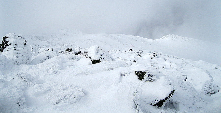
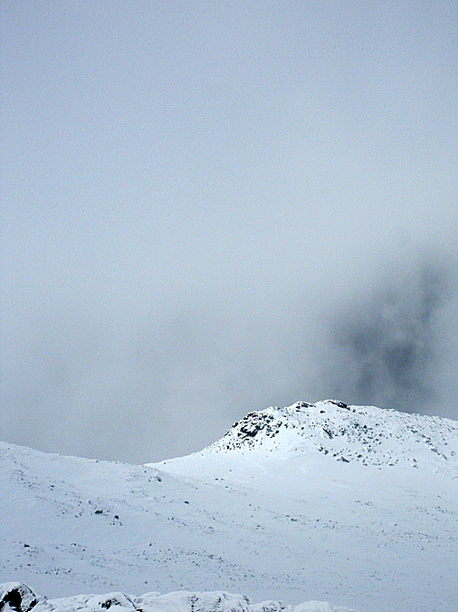
- As we ascended the bluebird skies quickly disappeared. The weather forecast was way off, a thick fog came rolling in and just sat on the Presidential Range above treeline. Luckily there was no wind so whiteout conditions would not come into play.
- The Valley Way Trail gets steeper as it climbs closer to Madison Spring Hut. I ended up putting on my snowshoes just below treeline and kept them on the the rest of the day.
- We made it to Madison Spring Hut just before 10 a.m. and took a nice break to refuel and layer up before the exposed hike up the summit cone of Mount Madison. Scott put on his snowshoes and noticed that the hook the strap connects to was missing so he used an EMS clip to hold the strap on.
- It was eerie hiking up the Osgood Trail, there was almost no wind and the visibility was low. The trail was a mix of choppy snow, small drifts, boulders, and hidden boulders. The snowshoes took a beating up to the summit but we made it there with no issues and Scott's snowshoe was holding up perfectly.
- We made a quick descent back to the hut where we relaxed before heading south on the Gulfside Trail to the Airline on our way up to Mount Adams. The Gulfside Trail was easy to follow and there were a couple of barebooters and one snowshoe track that we followed up out of the Madison / JQ Adams Col.
- Unfortunately, the tracks stayed straight ahead on the Gulfside Trail towards Thunderstorm Junction instead of banging a left up the Airline. The other hikers were 'back-dooring' Adams which I prefer to do in the summer (yikes, that line just sounds dirty!). The Airline has small cairns where the Gulfside to Thunderstorm Junction and Lowe's Path to the summit from there have much better cairns.
- Since there was absolutely no wind I wasn't worried even with the very low visibility. Other than one spot we could always find the next cairn. It was a pretty freaking cool ascent up the summit cone of Mount Adams, it felt like we were on the moon.
- We plodded up one step at a time and made it to the completely viewless and windless summit. To get a better understanding of how rare it is to have no wind on Mount Adams, you're lucky if it's 'howling.' You can count the windless winter days on one hand.
- We took a nice break on the summit, long enough to catch a glimpse of some views down into Jefferson Ravine and Mount Sam Adams and Abigail Adams (formerly known and Adams IV) but it never broke open. Another hiker who was doing a time lapse from he summit made his way up just before we headed down.
- Descending the Airline is never too fun, I almost took us off the trail at first but kept us on track back to the Airline / Gulfside Junction. From here we dropped back down to the hut. Along the way we ran into Hiker Ed who was looking to catch up with one of his friends on his way to Mount Admas.
- We made great time back to the car, the Valley Way Trail is built for speed in the winter. As we got closer to the trailhead we veered off onto one of the scenic bypasses where we ran into the family from Deliverance and passed by a shack which I had never seen before.
- We made it back to the car a little before 3 p.m. It was a great hike and is just what I needed. Thanks Scott for a fun day in the Northern Presi's!


- I left RI at 3 a.m. and arrived at my favorite trailhead, Appalachia, at 6:30 a.m. where Scott was starting to gear up. We hit the trail around 6:45 a.m. and made our way up the Valley Way with bluebird skies above us and Mount Madison and Adams in the clear.
- A couple of minutes into the hike we were passed by a solo hiker attempting a one day Presidential Traverse. It seemed like the perfect day for it with the higher summits calling for in and out of the clouds.
- The Valley Way is a heavily used trail so it was well broken out and we both barebooted for the first two miles before putting on microspikes.
- As we ascended the bluebird skies quickly disappeared. The weather forecast was way off, a thick fog came rolling in and just sat on the Presidential Range above treeline. Luckily there was no wind so whiteout conditions would not come into play.
- The Valley Way Trail gets steeper as it climbs closer to Madison Spring Hut. I ended up putting on my snowshoes just below treeline and kept them on the the rest of the day.
- We made it to Madison Spring Hut just before 10 a.m. and took a nice break to refuel and layer up before the exposed hike up the summit cone of Mount Madison. Scott put on his snowshoes and noticed that the hook the strap connects to was missing so he used an EMS clip to hold the strap on.
- It was eerie hiking up the Osgood Trail, there was almost no wind and the visibility was low. The trail was a mix of choppy snow, small drifts, boulders, and hidden boulders. The snowshoes took a beating up to the summit but we made it there with no issues and Scott's snowshoe was holding up perfectly.
- We made a quick descent back to the hut where we relaxed before heading south on the Gulfside Trail to the Airline on our way up to Mount Adams. The Gulfside Trail was easy to follow and there were a couple of barebooters and one snowshoe track that we followed up out of the Madison / JQ Adams Col.
- Unfortunately, the tracks stayed straight ahead on the Gulfside Trail towards Thunderstorm Junction instead of banging a left up the Airline. The other hikers were 'back-dooring' Adams which I prefer to do in the summer (yikes, that line just sounds dirty!). The Airline has small cairns where the Gulfside to Thunderstorm Junction and Lowe's Path to the summit from there have much better cairns.
- Since there was absolutely no wind I wasn't worried even with the very low visibility. Other than one spot we could always find the next cairn. It was a pretty freaking cool ascent up the summit cone of Mount Adams, it felt like we were on the moon.
- We plodded up one step at a time and made it to the completely viewless and windless summit. To get a better understanding of how rare it is to have no wind on Mount Adams, you're lucky if it's 'howling.' You can count the windless winter days on one hand.
- We took a nice break on the summit, long enough to catch a glimpse of some views down into Jefferson Ravine and Mount Sam Adams and Abigail Adams (formerly known and Adams IV) but it never broke open. Another hiker who was doing a time lapse from he summit made his way up just before we headed down.
- Descending the Airline is never too fun, I almost took us off the trail at first but kept us on track back to the Airline / Gulfside Junction. From here we dropped back down to the hut. Along the way we ran into Hiker Ed who was looking to catch up with one of his friends on his way to Mount Admas.
- We made great time back to the car, the Valley Way Trail is built for speed in the winter. As we got closer to the trailhead we veered off onto one of the scenic bypasses where we ran into the family from Deliverance and passed by a shack which I had never seen before.
- We made it back to the car a little before 3 p.m. It was a great hike and is just what I needed. Thanks Scott for a fun day in the Northern Presi's!
Valley Way
Ascending the Valley Way Trail
Winter Wonderland
View from the Valley Way Trail
Scott on the Valley Way Trail
Approaching treeline
Alpine Zone
Weather Warning Sign
Madison Spring Hut
Madison Spring Flats
Madison Spring Hut
Madison Spring Hut
Madison Spring Hut
Scott popping out above treeline
Scott approaching the hut
Osgood Trail
Scott ascending the Osgood Trail
Osgood Trail
Mount Madison Ghost!
Madison Summit Ridge
Mount Madison
Mount Madison Summit
Madison Spring Hut
Madison Spring Hut
Madison Spring Hut
Gulfside
Ascending the Gulfside Trail
Airline
Airline
Scott Ascending the Airline
Airline
Scott looking for the best route
Rime Ice blasted Boulders
Rime Ice
Feathered Rime Ice
Scott approaching the summit of Mount Adams
Mount Adams
Mount Adams Summit
Mount Adams Summit
Myself on the Summit of Mount Adams
Scott striking a pose!
Mount Abigail Adams bump on the lower right
Mount Abigail Adams
Jefferson Ravine
Lowe's Path
View from Mount Adams
Mount Abigail Adams
Mount Abigail Adams
Scott descending the Airline
Airline
Airline / Gulfside Junction
Abigail Adams
Over the lip down into the Madison / J.Q. Adams Col
Gulfside
Madison Spring Haunted Hut
Madison Spring Hut
Madison Spring Hut
Madison Spring Hut
Valley Way
Old shack near the Maple Way Trail and the power lines
???
Power Lines before the trailhead
Old Boston to Maine Railroad
Really enjoyed both your write-up & photos of your hike up Madison & Adams. My son & I did a similar hike (Adams via Valley Way) on 2/22. On that day, we also had NO WIND and clear skies once we got above tree line. Although you hike a little fasted than I do (we started from Appalacia at 6:00 A and returned by 4:30 P) your notes & photosbrought back happy memories from a great day in the Presidentials. Please keep hiking & writing.
ReplyDeleteGlad you and your son had a great day up there!
Delete