Showing posts with label Mount Hayes. Show all posts

Homeward Bound Loop

Elevation over distance profile (Strava Link)

 
9/20/25

Road Walk & Logging Road: 1.0 miles  /  Stony Brook Trail: 2.8 miles  /  Carter Moriah Trail: 1.2 miles  /  Kenduskeag Trail: 1.4 miles  /  Rattle River Trail: 4.3 miles  /  Road Walk: 0.7 miles  /  Centennial Trail: 3.1 miles  /  Mahoosuc Trail: 3.8 miles  /  Road Walk: 0.5 miles  /  Coos Trail Network: 1.2 miles  /  Pine Mountain Trail: 2.4 miles  /  Ledge Trail: 0.6 miles  /  Pine Mountain Road: 0.8 miles  /  Pine Link : 2.4 miles  /  Watson Path: 0.3 miles  /  Osgood Trail: 0.5 miles  /  Daniel Webster Scout Trail: 3.3 miles  /  Hayes-Copp Ski Trail & Pinkham B Road: 1.5 miles  /  Snowmobile Trail & Bushwhack: 4.5 miles
Total Miles: 36.3 (11,700' elevation gained)

Trip Report:
- On the last full day of summer, I took advantage of the cool and crisp weather to do a loop that started and ended at my home.
- At first light, I walked out my front door, crossed NH16, and bypassed the first mile of the Stony Brook Trail by walking through the neighborhood and an old logging road, intersecting the trail after the first water crossing. 

Early morning walking through the Stony Brook neighborhood. Pine Mountain in view

- Stony Brook Trail is not exciting, it has no views, and takes its sweet time to gain the ridge where it comes to the junction with the Carter Moriah Trail. Once on the Carter Moriah Trail, it is 1.2 miles to the summit of Mount Moriah. Along the way, the trail ascends over a couple of open ledges with great views of the Carter Range to the south and the Northern Presidential Range to the west.

Mount Adams and Madison to the left and Pine Mountain, where I will be later in the day, on the right, looking like a small lump!

A.T. blaze cairn with the Presidential Range off in the distance

Mount Moriah summit. Carter Range and Presidential Range in view. Beautiful, crystal-clear day for views!

- From the summit of Mount Moriah, I descended Kenduskeag and Rattle River trails, both part of the Appalachian Trail. Kenduskeag has several bog bridges, which made for easy travel over the usual muddy sections that are bone dry because of the summer drought. Rattle River Trail drops steeply for 1.5 miles before a gradual, excellent footed descent over the final 2.5 miles. Along the way, it passes by the Rattle River shelter, which appeared to be empty. 

Well placed bog bridges on the Rattle River Trail

Nice and cushy descent of the lower half of the Rattle River Trail

Rattle River shelter

- Rattle River Trail ends on U.S. Route 2. From the trailhead I had a 0.75 mile road walk on Route 2, North Road, and Hogan Road. It's an easy road walk with a nice view from the hydro dam bridge over the Androscoggin River.

Mount Madison's Osgood Ridge (right), and Mount Washington (left) from the dam

- Part II of the day was to continue along the A.T. up to Mount Hayes before dropping down to Main Street in Gorham. The hike up to the junction with the Mahoosuc Trail is over gradual grades and decent footing. I passed a few Thru-Hikers along the way and wished them luck as they headed into Maine.
- At the junction, I parted ways with the A.T., headed over Mount Hayes, past the ledges, and quickly made my way down the mountain and into town.
- Originally, my plan was to head to Irving to stock up on water and some tasty treats, but they had just started renovations on the building, and the only items available to buy were beer, energy drinks, and scratch tickets. To make sure I had water, I stashed a gallon at the trailhead Friday evening. 
- Before I walked through town, I took a short break, refilled my water bladder, ate some snacks, and organized my pack.

Appalachian Trail marker on the Centennial Trail

Mahoosuc Trail junction at the north peak of Mount Hayes

Soft cushy trails along the summit of Mount Hayes

Town of Gorham as seen from Hayes ledges. Most of my route can be seen in this picture, Moriah to the left, Pine is the little lump on the right, with Madison rising high above it.

Hydro dam on the Androscoggin River located on Hogan Road

ATV/Bike/Pedestrian bridge over Route 16 in Gorham

- Part III; Up and over Pine Mountain. I made my way across the Gorham airfield, hooked onto the Coos Trail network, and intersected the Pine Mountain Trail. Pine Mountain Trail has good footing with easy grades, and I was able to quickly make my way to Chapel Rock, Horton Center, the summit, the ledges, and down to Pine Mountain Road on my way to Pinkham B Road and the Pine Link Trailhead.
- I started to feel a little wonky during the road walk, so when I reached the Pine Link trailhead, I took a short break to stuff my face with a cinnamon bun and chug some Gatorade, instantly feeling better.

Gorham Airfield

Coos Trail Network

Chapel Rock

Horton Center

Pine Mountain Ledges (Madison on the right, Carter/Cats on the left)

- Part IV: The crux of the loop, ascending the steep and rough Pine Link and Watson Path to Mount Madison's summit. I throttled down to conserve my energy as Pine Link Trail until the Howker Ridge Trail junction is a real slog. The two trails coincide for about a half mile and then Pine Link shoots straight for the west side of the summit cone, reaching treeline in short order and the junction with the Watson Path. 
- Once I hit treeline, I had a rush of energy as the breeze and cool temps made the hike much more enjoyable than it had been just moments before when I was in the trees.
- I carefully made my way up the final 0.3 miles to the summit on the Watson Path and reached the summit at 2PM. 
- At the top, I sat down and enjoyed the views of the Great Gulf, Mount Adams, Washington, etc, before a half-mile descent along the Osgood Trail followed by a steep drop down to Dolly Copp Campground via Daniel Webster Scout Trail.
- The DWS trail is rough and rugged for the first 1.5 miles, traversing well below Osgood Ridge at an odd angle on jumbled boulders before dropping below treeline, where mercifully the trail becomes much easier to navigate.
- When I got within 0.3 miles of the end of the trail and the campground, I banged a left onto the Hayes-Copp ski trail to Pinkham B Road for the last part of my Homeward Bound Loop along a snowmobile corridor

Heading up the Pine Link Trail to Mount Madison

Adams and Washington as seen from Mount Madison's summit

Osgood Ridge

Along the Daniel Webster Scout Trail looking back at where I came from. The Pine Link Trail travels up the ridge in the forefront, Pine Mountain below that in the middle right, and Mount Hayes at the top right

- Part V: Snowmobile & Bushwhack solitude. The final four miles were a relatively easy trek along the snowmobile trail that parallels the Peabody River about a quarter to half mile to the west of the river. 
- The snowmo trail has some small rolling hills to deal with, but the path is clear and only gets a little brushy right before I jumped off and started my bushwhack.
- The whack is relatively short-lived, 0.25 mile before steeply dropping down to the river, followed by 0.25 mile of easy river walking back to my home, arriving at 4PM, just under ten hours after I started.
- Starting and ending at my home made for a fun experience, and I'm looking forward to creating another home-to-home loop involving the Wild River Wilderness and the Carter Range next summer.

The snowmobile trail travels through a wide-open field with a unique view of Mount Madison

Junked truck from the 1950's along the snowmobile trail. Soon after this, I jumped off the trail and made my way to the river

Peabody River, a few minutes upstream from my home :) 

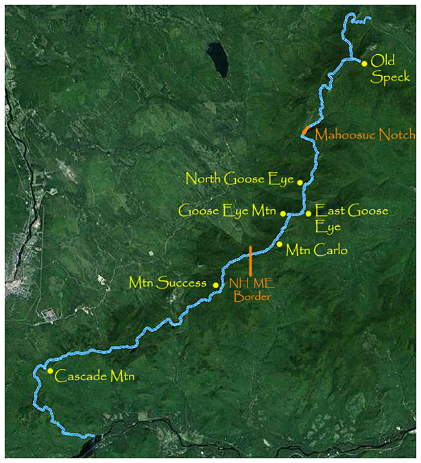
Mahoosuc Range Traverse

Date of Hike: 6/14/15

Old Speck Trail: 3.2 miles  /  Mahoosuc Trail: 22.6 miles  /  Centennial Trail: 2.8 miles
Total Miles: 28.6 miles (10,285 feet elevation gained) Garmin Forerunner 910XT
 31.2 miles (10,750' gained) White Mountain Guide Book


Trip Report:
- For the past four years I've been itching to do a one day Mahoosuc Range Traverse but just never could make it happen.  From a logistic standpoint it's tougher to make this hike happen, you need a car spot and you have to head into Maine so it's a haul.  Most important you need decent weather as the trails are very rough and unforgiving.
- Finally this past Sunday everything came together, car spot, weather, two other strong hiker/runners (Kyle and Tony).  This was going to be a fast hike but with minimal running, as I had never been on any of the trails south of Old Speck's summit, and wanted to take it all in and document it for the blog and familiarize myself with the terrain.
- We met at McDonald's in Gorham where Tony informed us he was going to sit this one out, the day before he hiked the Tripyramids and his calve muscle was giving him issues and he did not want to chance it over 30 brutal miles.  It was unfortunate that he couldn't make it but extremely nice of him to give us a car spot off Route 2 on Hogan Road and driving us over to Grafton Notch, saving us close to two hours of driving after the hike was over, huge thanks to Tony!
- Kyle and I started up the Old Speck Trail just after 7 a.m.  The weather was perfect, temperatures were in the 50's, there was a calm breeze, under mostly sunny skies. We made good time up the Old Speck Trail, it has some steep short bursts mixed in with moderate grades but nothing we are not used to.  The footing is decent to rough as it heads through the woods until it gains the ridge a few tenths of a mile short of Old Speck's summit and it's tower.  At the summit we climbed the tower where we had great views, including one looking south over the route we were about to tackle.
- From the summit we headed south on the Mahoosuc Trail to Speck Pond Campsite.  The trail down to the campsite was slab, rocks, and roots, it was wet in spots but not too bad overall.  There were a few tent platforms with hikers breaking down camp and one guy sound asleep in his sleeping bag in the lean-to.  The Mahoosuc Trail then headed around the eastern rocky banks of Speck Pond before reaching its outlet where we had a great view of the pond.  From the pond the trail ascended steeply up to Mahoosuc Arm where there were some great views from rocky ledges, to the north we could see Old Speck and to the east we could see Sunday River ski area.  After topping out on the arm the trail descended at a ridiculously steep grade over very brutal footing of slick slab followed by some nasty boulders before reaching the foot of the infamous Mahoosuc Notch.
- The Mahoosuc Notch has been branded the "Hardest Mile on the A.T."  It's a mile long minefield of boulders where care is required in order to navigate over, under, and around car to house sized boulders out the other side of the notch.  Going in I thought it was going to be a tougher version of the Subway and Ice Caves in the King Ravine.  After going though it I can honestly say it's not as physically demanding as those, just longer.  Still it was a tremendous amount of fun heading through the notch.  We also lucked out as the trail crew had come through and cleaned out a massive amount of blowdowns over the last third of a mile through the notch, incredible trail work.  There must have been a huge storm burst over the Mahoosuc Range recently because over the next fifteen miles there were cleared blowdowns on half of the trail!
- After passing through the notch we banged an immediate left and started the steep climb up to the Full Goose Campsite.  This site was pretty cool as it sits on a small shelf on the northern shoulder of North Goose Eye Mountain.  Above and below the campsite is pretty steep terrain, just past the campsite there is a section of iron wrungs to help hikers up a steep wet mossy slab section.
- The next few miles of the hike were my absolute favorite of the day, hiking over North, East, and the main peak of Goose Eye Mountain.  The Mahoosuc Trail travels in and out of the scrub and though a beautiful alpine meadow between the peaks over moderate grades of slab with one steep burst north of East Goose.  The trail had one curve ball as we headed along the alpine meadow...waist deep mud pits which luckily I had been warned about from Whitney who hiked through here last August during her A.T. thru-hike.  Thankfully we were able to stay on the bog bridges and navigate around the worst mud pits only going in ankle deep once or twice.  I consider this a win!
- After Goose Eye, the trail took on a 'Garfield Ridge' type feel to it, up and downs with rough footing as we headed over Mount Carlo, down to the Carlo Col, across the state line, and up to Mount Success where we took a much needed break to enjoy our last great view spot of the day.
- From Mount Success the Mahoosuc Trail heads through another alpine and scrub section before heading into the woods for good as it starts the long descent down to the Austin Brook and Gentian Pond.  I was not a fan of this descent, it became rough and steep and I could not get into a good hiking pace, it became tiring to shift into different speeds over some really crummy footing.  I hit my only wall of the day through here, the water I filtered in the North/East Goose Eye col was not refreshing anymore.  Luckily the Austin Brook was flowing at a good rate and we both filtered some much needed cold/refreshing water and fueled up before heading up to Gentian Pond and then by Dream Lake.
- After Dream Lake the trail started to get a little overgrown and narrow in spots as we headed up past a decent outlook at Wocket Ledge.  From here the trail eased up quite a bit footing wise.  It became mostly dirt with only a few short boulder or slab sections.  However, the trail workers had yet to make it this far south and the blowdowns were now in the trail.  Luckily there weren't too many bad spots and the trail was easy to pick up on the other side of the blowdowns.  The worst spot was in the woods just north of Cascade Mountain's summit.
- From Cascade Mountain we could see Mount Hayes, which would be our final high point of the day before booking it down the Centennial Trail to Hogan Road, bypassing the final 2.5 miles of the Mahoosuc Trail and the nasty bugs that eat hikers alive on the lower end of that section.
- The hike between Cascade and Hayes was pretty tame, the footing was good and the grades were easy to moderate and we made it to the Centennial Trail junction just after 5:30 p.m.  From here we ran down to Hogan Road and made great time and really finished with a flurry.  With a quarter mile to go I tripped and crashed to the ground, it was my worst fall ever in the White Mountains but was on dirt so I got off lucky with just a bruised ring finger and a nasty raspberry burn on my shoulder and upper bicep.  After the fall, I got up, dusted myself off, and we ran it in to the trailhead finishing the Mahoosuc Traverse in 10 hours 59 minutes and 48 seconds!
- We quickly jumped in our cars to escape the most vicious mosquitoes I have ever encountered!  I was covered in dirt and blood from my fall so we headed to Gorham and jumped in the small public man made pond that has a sandy beach on Route 16.  It felt good to cool off and clean all the dirt, sweat, and blood off of me.  After relaxing in the pond we headed to Mr. Pizza to stuff our faces before going our separate ways.
- The Mahoosuc Traverse was definitely tougher than a Presi Traverse or a Pemi Loop.  I still prefer the other two because of the views but this one is right up there for hikers/runners who want an extreme challenge.  I am looking forward to getting back and hiking some of the trails up to the Mahoosuc Range, especially those that go up to the Goose Eyes, plus I want to find the downed plane a little further south on Mount Success as well.
- I'll eventually do another one day traverse but not in the foreseeable future.  I'm grateful I got to enjoy it with my friend Kyle, he's a very strong hiker / runner who set a great pace for the whole day and didn't mind me throttling down to take hundreds of pictures along the way.
- The hike went better than expected and I am happy to check another bucket-list hike off my to-do list!

Old Speck Trailhead in Grafton Notch

The Old Speck Trail travels by Cascade Brook which has some nice little falls and cascades along the trail

 The trail passes by a few ledgy outlooks where you can spy the summit of Old Speck

 The Old Speck Trail has the usual rocky footing as it gains the ridge

 Old Speck summit tower

 A sign and a welded signature located at the bottom of the tower

 Sunday River 

 View to the east from the top of the tower

 Our route for the day, south along the Mahoosuc Range

 Heading to Speck Pond Campsite

 Speck Pond

The trail up from Speck Pond to Mahoosuc Arm.  Looking back you can see Old Speck Mountain

 Looking down to Mahoosuc Notch

 The rough and rugged descent to the foot of the notch

Kyle makes his way through Mahoosuc Notch

 The trail goes under and over huge boulders

 Kyle navigates a ledge and an icy section

 Heading through Mahoosuc Notch

 The last few tenths of a mile was blowdown city!

 After the notch we head up to Full Goose Campsite.  Along the way we head through a nice alpine meadow

 Beautiful stretch of the Mahoosuc Trail

 Full Goose Shelter

 Using the rebar for a helping hand!

Traveling through the picturesque alpine meadow along the Goose Eyes 

 Kyle heads to East Goose Eye

 East Goose Eye

 East and main peak of Goose Eye

 East and main peak (top), North Goose eye (bottom)

 Descending East Goose Eye with Goose Eye in sight

 Looking back north to East Goose Eye, Mahoosuc, and Old Speck (top).  Looking south to Carlo and Mount Success (bottom)

 Kyle makes his way through the steep descent off of Goose Eye

 The A.T. along Mount Carlo

Back in NH!

 Mount Success summit

 Great hiking and view just south of Mount Success

 Back into the woods heading down to Austin Brook

 Along the Mahoosuc Trail.  This is either Gentian Pond or Dream Lake. I can't remember

The trail starts to take on a more dirt path than the tedious boulder and rock bed 

 Kyle heads along a muddy section and a bog bridge section 

 Page Pond

 Heading up past Trident Pass

 Making our way to Cascade Mountain with the Moriah - Carter Range coming into view

 The trail got really narrow in spots 

 Other spots of the trail had some blowdowns to navigate

 Mount Hayes from Cascade Mountain

 Kyle makes his way up Mount Hayes where we bang a left before the summit and descend the Centennial Trail back to Hogan Road

 Trail signs from Grafton Notch to Speck Pond

 Trail Signs from Speck Pond to the NH border

 Trail signs from NH Border to Hogan Road

Route for the day, click here for details

Mileage, time, and elevation data

Splits