
Date of Hike: 7/5/14
Van Hovenburg Trail: 1.0 miles / Algonquin Trail: 2.1 miles / Wight Peak Spur: 1.0 miles / Algonquin Trail: 1.0 miles / Iroquois Herd Path: 1.4 miles / Algonquin Trail: 1.1 miles / Lake Colden & Avalanche Pass: 3.3 miles / Van Hovenburg Trail: 2.3 miles
Total Miles 13.0 (GPS 14.1 miles, 4,750 elevation gained)
Trip Report:
- After a long time away from hiking in the Adirondacks I finally made it back for two incredible days of hiking in the High Peaks Wilderness. On Saturday I drove up to Keene Valley to meet Erin for one of my favorite hikes, Wright, Algonquin, and Iroquois of the Macintyre Range. The hike involves over a mile of above treeline hiking with some of the most stunning views in the Adirondacks.
- We got on the trail pretty early, just after 8 a.m. Since it was a holiday weekend the trailhead at the Adirondack Loj was jammed packed with cars, the most I had ever seen. We were stopped by the ranger who forced us to sign in at the kiosk. For some reason this really annoyed me! In the past the rangers just asked where I was going and never hassled me, I've usually signed in only when going to remote peaks.
- Anyway, we jogged the first mile or so past the conga line heading up to Mount Marcy before veering off on the Algonquin Trail. From here the number of hikers dropped and we would run into people here and there. We were on the trail early enough that it was never too crowded on the trails or the summits.
- The trail to the Wright Spur Path starts off nice and gradual with good footing over dirt, then it becomes filled with rocks and roots while getting a little steeper, then it transitions to rock slab just before hitting the spur trail.
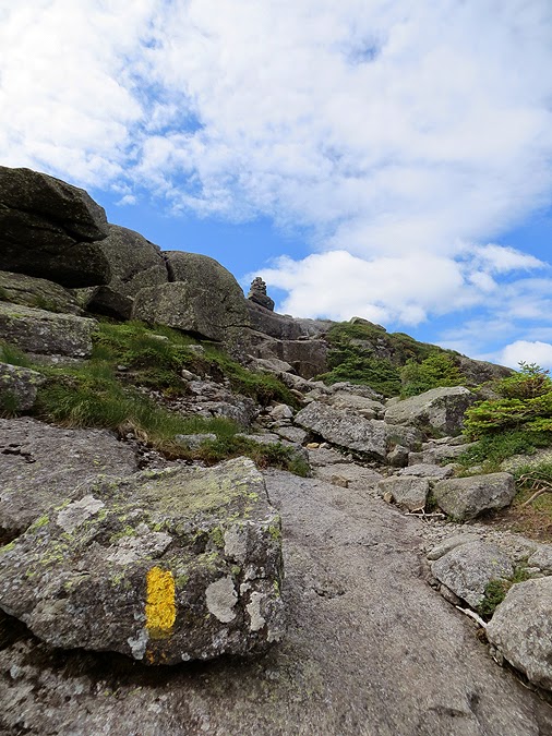
- The Wright Spur Path has one of the steepest bursts of trail up a summit cone in the Adirondacks. It's all slab marks with yellow paint and cairns, one of which is the best looking cairn in the Adirondacks! Wright Peak also has another thing going for it, it's extremely windy! Erin and I both had to put on long sleeves, and remove our hats or they would have blown off into the abyss down towards Avalanche Pass.
- At the summit we got out of the wind for a few minutes and talked to the summit steward who was a very nice young girl who spends most days up on the summit between 10 and 4. After warming up and refueling we headed over to the airplane wreckage from where the bomber flew into the mountain fifty years ago before escaping the wind back into the woods.
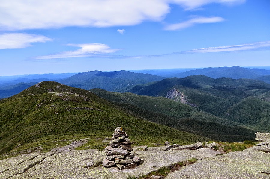
- Next up was the steep ascent up to the summit of Algonquin. Amazingly, it was not as windy on the summit which was a great so we could enjoy the tremendous views, the most dramatic of which is Mount Colden, it's slides, and the Trap Dike. Other views from where we took a break were of the Great Range to the east and Lake Colden along with Flowed Lands a few thousand feet below and to the south.
- From the summit we jogged down to the col where we headed over Boundary Peak on our way to Iroquois. I was really looking forward to this part as I heard they had installed bog bridges over the nasty mud sections. One of my first High Peaks hikes I remember navigating this mud pit where I fell in shin deep, it was my first up close and personal experience with the ADK mud. The bridges are well placed and there were only a few minor mud sections, Erin had one of her trail runners fall into a small mud patch, I told her it was a right of passage to hiking here!
- Views from Iroquois were just as excellent as Wright and Algonquin. I consider the views for this hike the equivalent of the Franconia Ridge in the White Mountains.
- The next part of the hike is the drop in elevation to Lake Colden. It's very steep and the footing is extremely rough for the majority of the mile descent. The trail travels over a brook bed with awkward boulders and roots. There are some attractive mini cascades along the way, one section you get to hike over the slab before heading back into the woods before reaching the bottom of the trail.
- At the bottom we took a break on a footbridge before heading into Avalanche Pass where we got an up close and personal look at the Trap Dike rising high above Avalanche Lake. From here we hiked over the 'Hitch Up Maltidas' and through the boulder section along the shore over old ladder steps and wooden planks. I haven't been through here in almost three years so it was a real treat to be back. Avalanche Lake and the pass were absolutely breathtaking with the clouds floating high above Mount Colden and Avalanche Mountain.
- After Avalanche Pass we jogged to Marcy Damn and took in the final views of the day before the boring last couple of miles back to the car which luckily went by quickly because we were both starving.
- When we got back to the trailhead we changed into clean clothes and headed to Lake Placid to enjoy a much needed late lunch and a couple of drinks at Delta Blue. The food hit the spot and the town of Placid was swarming with holiday traffic. It was a lot of fun to people watch while grabbing a bite to eat.
- Afterwards I dropped Erin back at her car and I crashed at the Keene Valley Hostel and sat by the fire with the other hikers/climbers spending the night. It was a perfect way to rest up for my next days hike of the Great Range. Click here to view that report and pictures!


Van Hovenburg Trail: 1.0 miles / Algonquin Trail: 2.1 miles / Wight Peak Spur: 1.0 miles / Algonquin Trail: 1.0 miles / Iroquois Herd Path: 1.4 miles / Algonquin Trail: 1.1 miles / Lake Colden & Avalanche Pass: 3.3 miles / Van Hovenburg Trail: 2.3 miles
Total Miles 13.0 (GPS 14.1 miles, 4,750 elevation gained)
Trip Report:
- After a long time away from hiking in the Adirondacks I finally made it back for two incredible days of hiking in the High Peaks Wilderness. On Saturday I drove up to Keene Valley to meet Erin for one of my favorite hikes, Wright, Algonquin, and Iroquois of the Macintyre Range. The hike involves over a mile of above treeline hiking with some of the most stunning views in the Adirondacks.
- We got on the trail pretty early, just after 8 a.m. Since it was a holiday weekend the trailhead at the Adirondack Loj was jammed packed with cars, the most I had ever seen. We were stopped by the ranger who forced us to sign in at the kiosk. For some reason this really annoyed me! In the past the rangers just asked where I was going and never hassled me, I've usually signed in only when going to remote peaks.
- Anyway, we jogged the first mile or so past the conga line heading up to Mount Marcy before veering off on the Algonquin Trail. From here the number of hikers dropped and we would run into people here and there. We were on the trail early enough that it was never too crowded on the trails or the summits.
- The trail to the Wright Spur Path starts off nice and gradual with good footing over dirt, then it becomes filled with rocks and roots while getting a little steeper, then it transitions to rock slab just before hitting the spur trail.
- The Wright Spur Path has one of the steepest bursts of trail up a summit cone in the Adirondacks. It's all slab marks with yellow paint and cairns, one of which is the best looking cairn in the Adirondacks! Wright Peak also has another thing going for it, it's extremely windy! Erin and I both had to put on long sleeves, and remove our hats or they would have blown off into the abyss down towards Avalanche Pass.
- At the summit we got out of the wind for a few minutes and talked to the summit steward who was a very nice young girl who spends most days up on the summit between 10 and 4. After warming up and refueling we headed over to the airplane wreckage from where the bomber flew into the mountain fifty years ago before escaping the wind back into the woods.
- Next up was the steep ascent up to the summit of Algonquin. Amazingly, it was not as windy on the summit which was a great so we could enjoy the tremendous views, the most dramatic of which is Mount Colden, it's slides, and the Trap Dike. Other views from where we took a break were of the Great Range to the east and Lake Colden along with Flowed Lands a few thousand feet below and to the south.
- From the summit we jogged down to the col where we headed over Boundary Peak on our way to Iroquois. I was really looking forward to this part as I heard they had installed bog bridges over the nasty mud sections. One of my first High Peaks hikes I remember navigating this mud pit where I fell in shin deep, it was my first up close and personal experience with the ADK mud. The bridges are well placed and there were only a few minor mud sections, Erin had one of her trail runners fall into a small mud patch, I told her it was a right of passage to hiking here!
- Views from Iroquois were just as excellent as Wright and Algonquin. I consider the views for this hike the equivalent of the Franconia Ridge in the White Mountains.
- The next part of the hike is the drop in elevation to Lake Colden. It's very steep and the footing is extremely rough for the majority of the mile descent. The trail travels over a brook bed with awkward boulders and roots. There are some attractive mini cascades along the way, one section you get to hike over the slab before heading back into the woods before reaching the bottom of the trail.
- At the bottom we took a break on a footbridge before heading into Avalanche Pass where we got an up close and personal look at the Trap Dike rising high above Avalanche Lake. From here we hiked over the 'Hitch Up Maltidas' and through the boulder section along the shore over old ladder steps and wooden planks. I haven't been through here in almost three years so it was a real treat to be back. Avalanche Lake and the pass were absolutely breathtaking with the clouds floating high above Mount Colden and Avalanche Mountain.
- After Avalanche Pass we jogged to Marcy Damn and took in the final views of the day before the boring last couple of miles back to the car which luckily went by quickly because we were both starving.
- When we got back to the trailhead we changed into clean clothes and headed to Lake Placid to enjoy a much needed late lunch and a couple of drinks at Delta Blue. The food hit the spot and the town of Placid was swarming with holiday traffic. It was a lot of fun to people watch while grabbing a bite to eat.
- Afterwards I dropped Erin back at her car and I crashed at the Keene Valley Hostel and sat by the fire with the other hikers/climbers spending the night. It was a perfect way to rest up for my next days hike of the Great Range. Click here to view that report and pictures!
Algonquin Trail starts off nice and gradual
Then it gets a little steeper. Erin scrambling up
A nice little gem pool along the way
Weather warning sign around 3,500 feet
Erin makes her way up a wet and steep ledge section
Heading up into the bright sun on the Wright Spur Path
Erin gets a good handhold on the ledge that takes you above treeline
Looking down at Heart Lake
Mount Whiteface
Lake Placid
The 1980 Olympic Ski Jumps
Looking down at the steep Wright Spur Path
Heading up the summit cone of Wright Peak
Algonquin Peak rising high above to the south
The majestic cairn on Wright Peak
Erin hiking by the six foot tall cairn
The Great Range is seen to the west
Mount Colden with Marcy behind it
Airplane wreckage
Memorial Plaque
Some small parts of the crash remain
Another part, maybe a hydraulic for the landing gear
Bog Slide Mountain looming off in the distance
Heading back down the Wright Spur Path
Erin trail running down the steep slab as the clouds pass overhead
Wright / Algonquin Trail Junction. Time for new signs!
Heading up to Algonquin Peak
Entering the Alpine Zone
Hiking up the north ridge of Algonquin Peak
View to the southwest to the Seward Range
Wallface, a mountain climbers happy place
Street and Nye Peaks
Looking back down the trail. Wright Peak in view, notice how far below it is compared to Algonquin Peak
Cascade and Pitchoff Mountains
McNaughton and the Seward Range
McNaughton / Wallface Ponds
Summit of Algonquin Peak
Mount Colden
The Trap Dike and the slides of Colden
The Great Range
In this picture are the cliffs of Saddleback on the right and the summit of Gothics and its scarred walls
UFO clouds above Mount Marcy and Grey Peak
Flowed Lands
Lake Colden, Flowed Lands and Allen Peak
Rock family on the summit of Algonquin
Descending Algonquin Peak. Boundary and Iroquois Peak in view below
Algonquin Trail above treeline
Looking back to Algonquin Peak from the Iroquois Herd Path
Erin makes here way up to the summit
Trap Dike and Hurricane Irene Slide
Flowed Lands and Allen Mountain
Lake Colden and Mount Colden with the Great range behind it
Mount Marshall
Erin on Iroquois with Mount Colden behind her
Lake Colden
Flowed Lands
Gothics and Armstrong
Wallface
Sweard Range (Emmens, Donaldson, Seward, and Seymour)
Algonquin Peak
Looking down on the Boundary bog bridges
One misstep off this and you're going in a foot plus!
This looks safe...descending to Lake Colden
a nice little gem pool on the Algonquin Trail
Erin heading down the slab and mini cascade section
Mini cascade
Algonquin Brook
Heading into Avalanche Pass
Avalanche Lake
The Trap Dike
Hikers climbing up the dike's waterfall section, the crux of the climb, notice they are using a rope!
Hikers above the waterfall section of the dike
The beautiful Avalanche Lake
Trap Dike
Erin on the Hitch up Matilda's
Vegetation will grow just about anywhere!
Erin walking the planks
Avalanche Lake
Heading down an old rickety ladder
Ladder steps, make the way a little bit easier!
The end of Avalanche Lake
A collection of bog bridges and planks to keep you out of the mud
A nice little section along the walls of Colden
Marcy Dam mud flats, used to be a pond before the Damn was ruined
Marcy Damn
Marcy Damn
New bridge down stream from Marcy Damn
Map of Route, click here for more details
No comments:
Post a Comment