
Date of Hike: 9/4/13
Helon Taylor Trail: 3.2 miles / Knife Edge: 1.1 miles / Saddle Trail: 0.8 miles / Northwest Basin Trail: 1.0 miles / Hamlin Ridge Trail: 1.5 miles / North Basin Trail: 0.3 miles / Chimney Pond Trail: 3.1 miles
Total Miles: 11 miles (4,150 feet elevation gain)
Trip Report:
- About a month ago I was invited by Tim Lucia to join in for a trip to Baxter State Park. I was thrilled to be invited and jumped at the opportunity to head back to one of my favorite places I have ever hiked, Mount Katahdin and the Knife Edge!
- I would be joining six others on the trip Tim and Roberta who I hiked with up Isolation in the winter of 2012, Mike who I've ran into on the trails a few times over this past summer, his girlfriend Stefanie, and Whitney.
- We stayed at the Big Moose Cabins just a few miles from the park entrance. The cabin was a nice change for me as I had spent the past three nights in my tent off Little River Road in the rain! The cabin had a bunch of bunk beds, a kitchen, a screened in porch, bathroom, and a loft with more beds. It was a cozy cabin stocked with plenty of beer for post hike fun!
- We timed our hike perfectly as the rainy weather had finally passed through over night and as we climbed the clouds would clear off the mountain. We were on the trail just before 7a.m. at the Roaring Brook Campground trailhead.
- Out route for the day would take us up the Helon Taylor Trail, which I had descended twice but never ascended so I was pumped to be going up this way and cutting across the Knife Edge a different way.
- The seven of us hiked together up to treeline then we spread out while taking picture and stopping to enjoy the view up to Pamola Peak and Chimney Peak. The climbing was similar to the southern Presidential Range, lots of boulders mixed with gravel, transforming into all boulders found in the northern Presidential Range.
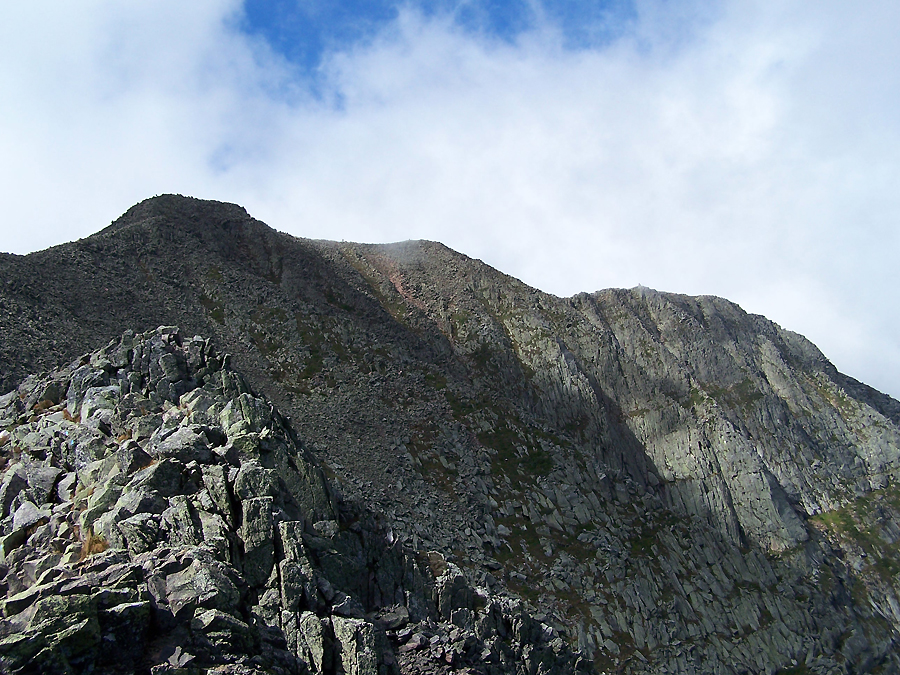
- Tim, Whitney, and myself motored our way up to Pamola Peak just as the clouds blew off the Knife Edge. What an incredible site, a gothic masterpiece of a razor edge filled with dramatic cliffs falling a thousand feet into an abyss called the Great Basin. I haven't been this taken back since 2009 when I first laid my eyes upon Bondcliff.
- As we waited for the others I watched other hikers slowly stagger there way across the Knife Edge only to have clouds come rushing back through and engulf the whole ridge hiding them from site. After a few minutes the clouds would blow off again and the whole ridge would be in the clear. Luckily for us the Knife Edge would stat in the clear until we reached South Peak.
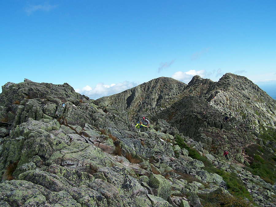
- As we started our trek across the Knife Edge the wind was roaring constantly in the 30 mph range with gusts into the mid to high 40 mph. It made for an intense trip down and up the Chimney to Chimney Peak. After that we skirted around then over the 'backbone' of the Knife Edge, which included a few crawling sections and 'no fall zones' where one fall would send you down to near Chimney Pond over 1,500 feet below.
- I never felt frightened by the Knife Edge, it was the third time I have done it. Once when I was around eleven years old and another time when I was twenty-seven. I don't remember much of those hikes other than this huge mountain rising out of nowhere deep in the Maine wilderness.
- We took our time crossing the Knife Edge, I spent most of the hike from South Peak to Baxter Peak hiking with Whitney. We were buried in the clouds at this point but it cleared up as we summited Baxter. There were several thru-hikers finishing their A.T. hike. It was a great site to see them standing on the back of the summit sign, there final stop on their 2,150 mile journey.
- We hung around Baxter Peak for awhile before we all started to get chilled and then started on our way off to Hamlin Peak. Heading down into the col was a gradual descent over northern presi type footing. Along the way you descend to what is called the 'Tableland' in the saddle between both peaks. The Tableland is filled with beautiful green, red, and purple colored rocks which resemble a rock shoreline along an ocean. It was great hiking through here and the views to the north of the Brothers and back behind us of the Knife Edge rising high above were majestic and phenomenal.
- The hike to Hamlin Peak was very easy, it was never steep, just really exposed. The amount of above treeline on Mount Katahdin is vast and the whole range seems as big as the whole Presidential Range but this is just one mammoth of a mountain. Pretty impressive sight to see.
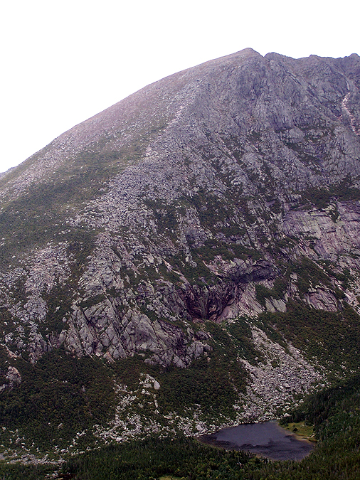
- The hike down Hamlin Ridge was reminiscent of the Osgood Ridge except with bigger views. Pamola, Chimney, South, and Baxter Peak loomed large above us with the Knife Edge and it's cliffs looking frighteningly impressive from below.
- Once back below treeline it was time for the relatively tame hike back to the car along the Chimney Pond Trail. We all made it back to the car withing fifteen minutes of each other close to twelve hours after we started. We each had an ice cold refreshing beer and snacks before heading back to Big Moose Cabins where Mike and Stef made a huge yummy dinner for everyone as we drank and ate the night away talking about the powerful awesomeness that is Mount Katahdin!


Helon Taylor Trail: 3.2 miles / Knife Edge: 1.1 miles / Saddle Trail: 0.8 miles / Northwest Basin Trail: 1.0 miles / Hamlin Ridge Trail: 1.5 miles / North Basin Trail: 0.3 miles / Chimney Pond Trail: 3.1 miles
Total Miles: 11 miles (4,150 feet elevation gain)
Trip Report:
- About a month ago I was invited by Tim Lucia to join in for a trip to Baxter State Park. I was thrilled to be invited and jumped at the opportunity to head back to one of my favorite places I have ever hiked, Mount Katahdin and the Knife Edge!
- I would be joining six others on the trip Tim and Roberta who I hiked with up Isolation in the winter of 2012, Mike who I've ran into on the trails a few times over this past summer, his girlfriend Stefanie, and Whitney.
- We stayed at the Big Moose Cabins just a few miles from the park entrance. The cabin was a nice change for me as I had spent the past three nights in my tent off Little River Road in the rain! The cabin had a bunch of bunk beds, a kitchen, a screened in porch, bathroom, and a loft with more beds. It was a cozy cabin stocked with plenty of beer for post hike fun!
- We timed our hike perfectly as the rainy weather had finally passed through over night and as we climbed the clouds would clear off the mountain. We were on the trail just before 7a.m. at the Roaring Brook Campground trailhead.
- Out route for the day would take us up the Helon Taylor Trail, which I had descended twice but never ascended so I was pumped to be going up this way and cutting across the Knife Edge a different way.
- The seven of us hiked together up to treeline then we spread out while taking picture and stopping to enjoy the view up to Pamola Peak and Chimney Peak. The climbing was similar to the southern Presidential Range, lots of boulders mixed with gravel, transforming into all boulders found in the northern Presidential Range.
- Tim, Whitney, and myself motored our way up to Pamola Peak just as the clouds blew off the Knife Edge. What an incredible site, a gothic masterpiece of a razor edge filled with dramatic cliffs falling a thousand feet into an abyss called the Great Basin. I haven't been this taken back since 2009 when I first laid my eyes upon Bondcliff.
- As we waited for the others I watched other hikers slowly stagger there way across the Knife Edge only to have clouds come rushing back through and engulf the whole ridge hiding them from site. After a few minutes the clouds would blow off again and the whole ridge would be in the clear. Luckily for us the Knife Edge would stat in the clear until we reached South Peak.
- As we started our trek across the Knife Edge the wind was roaring constantly in the 30 mph range with gusts into the mid to high 40 mph. It made for an intense trip down and up the Chimney to Chimney Peak. After that we skirted around then over the 'backbone' of the Knife Edge, which included a few crawling sections and 'no fall zones' where one fall would send you down to near Chimney Pond over 1,500 feet below.
- I never felt frightened by the Knife Edge, it was the third time I have done it. Once when I was around eleven years old and another time when I was twenty-seven. I don't remember much of those hikes other than this huge mountain rising out of nowhere deep in the Maine wilderness.
- We took our time crossing the Knife Edge, I spent most of the hike from South Peak to Baxter Peak hiking with Whitney. We were buried in the clouds at this point but it cleared up as we summited Baxter. There were several thru-hikers finishing their A.T. hike. It was a great site to see them standing on the back of the summit sign, there final stop on their 2,150 mile journey.
- We hung around Baxter Peak for awhile before we all started to get chilled and then started on our way off to Hamlin Peak. Heading down into the col was a gradual descent over northern presi type footing. Along the way you descend to what is called the 'Tableland' in the saddle between both peaks. The Tableland is filled with beautiful green, red, and purple colored rocks which resemble a rock shoreline along an ocean. It was great hiking through here and the views to the north of the Brothers and back behind us of the Knife Edge rising high above were majestic and phenomenal.
- The hike to Hamlin Peak was very easy, it was never steep, just really exposed. The amount of above treeline on Mount Katahdin is vast and the whole range seems as big as the whole Presidential Range but this is just one mammoth of a mountain. Pretty impressive sight to see.
- The hike down Hamlin Ridge was reminiscent of the Osgood Ridge except with bigger views. Pamola, Chimney, South, and Baxter Peak loomed large above us with the Knife Edge and it's cliffs looking frighteningly impressive from below.
- Once back below treeline it was time for the relatively tame hike back to the car along the Chimney Pond Trail. We all made it back to the car withing fifteen minutes of each other close to twelve hours after we started. We each had an ice cold refreshing beer and snacks before heading back to Big Moose Cabins where Mike and Stef made a huge yummy dinner for everyone as we drank and ate the night away talking about the powerful awesomeness that is Mount Katahdin!
Wilderness info sign at Roaring Brook
Chimney Pond Trail Sign
Trail info sign at Roaring Brook
Helon Taylor Trail info
Rainbow climbing out of the Great Basin
Helon Taylor Trail in the scrub approaching treeline
Looking down the Helon Taylor Trail
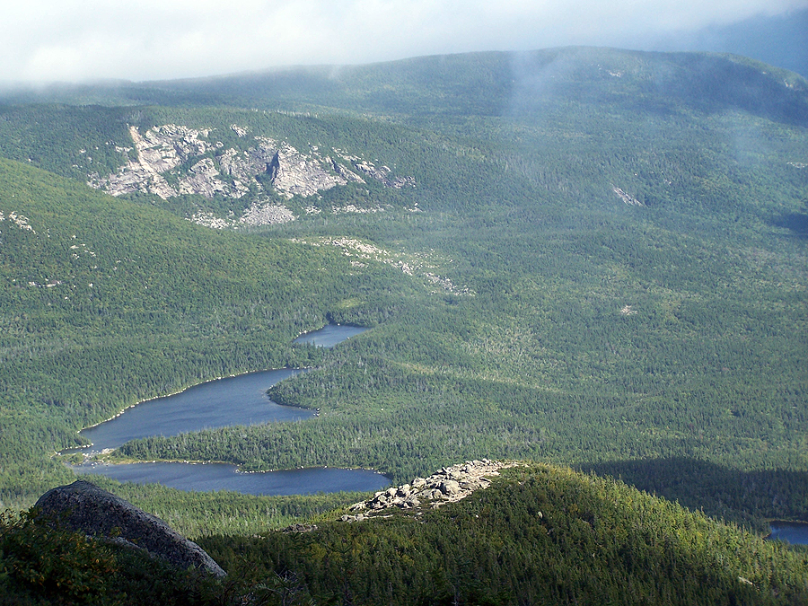
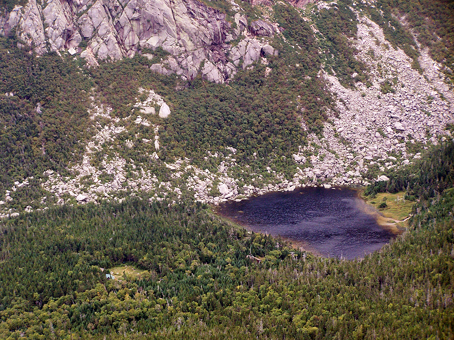
Basin Ponds
Katahdin Lake
First view of Chimney Peak
Pamola, Chimney Peak, and the beginning of the Knife Edge
First clear view of the Knife Edge
Helon Taylor Trail above treeline is a mixture of rocks, boulders, and gravel
Clouds rushing in over the Keep Ridge
Hiking up to Pamola Peak
Beautiful day to be above treeline!
Chimney Peak
Early morning sun battling with the clouds above Keep Ridge on the Helon Taylor Trail
The group making its way along the Helon Taylor Trail
Horizontal clouds and vertical clouds intertwining
Cool clouds above Keep Ridge
Helon Taylor Trail
Clouds swirling above Keep Ridge
A hiker in red tackles the Chimney
Keep Ridge
The knife Edge from Pamola Peak
Knife edge half covered in clouds
Pamola Peak
Pamola Peak summit
Knife Edge
Looking over to South Peak
Hikers climbing up the Chimney
Whitney makes her way off Pamola Peak
Two hikers from Maryland coming off of Pamola Peak
Mike and Stef 'down climbing'
Make and Stef descending Pamola Peak
Mike and Stef carefully making their way down into the Chimney / Pamola col
Mike and Stef carefully planning their next move
Looking back up to Pamola Peak
Pamola Peak
Hikers weaving their way off of Pamola Peak
Pamola Peak
The Knife Edge from Chimney Peak
Two hikers making their way across the spine of the Knife Edge
The Knife Edge is a jumbled narrow mass of rock that goes for a mile
Tim and Whitney lead the way
Roberta and Mark approaching the backbone
Chimney and Pamola Peaks
Slow going along the Knife Edge
South and Baxter Peaks
Roberta and Mark making their way through a short no fall zone section
Tim heads across a tough spot on his butt
Whitney and Tim battling the wind on the Knife Edge
Hiking across the Knife Edge, a couple of feet to the right is a 1,500 foot drop off
Chimney Pond
Look ma no hands!
Roberta making her way across a Razor Edge
The Knife Edge
Knife Edge to Baxter Peak
Sling Shot 'Y' Slide below the Tableland
Baxter Peak summit cairn
Baxter Peak
The Great Basin and Chimney Pond
Chimney Pond
Baxter Peak
Knife Edge
Knife Edge
Knife Edge
Mike making his way through the Knife Edge
The Knife Edge in full view
Knife Edge
Kinfe Edge from South Peak
Knife Edge from South Peak
Knife Edge
Knife Edge
Knife Edge
Pamola and Chimney Peak
Knife Edge from South Peak
The Knife Edge
Knife Edge
More of the same, the Knife Edge
Pamola and Chimney Peak
Knife Edge
The Knife Edge
Chimney Peak
Looking down into the Great Basin
Mount Katahdin Summit Plaque
The Knife Edge from Baxter Peak
Chimney Pond and the Great Basin
Chimney Peak
Saddle Trail Sign
The Sign
Dogs on Katahdin!
North Brother
Mount Coe
Double Top
Knife Edge
Knife Edge
Pamola and the Chimney
Group Photo!
Saddle Trail
Descending to the Saddle and Tableland
Hamlin Peak
Tableland
Hamlin Peak
Looking off towards Doubletop
Doubletop
Whitney leading the way through the Tableland
Baxter Peak Cut-Off Junction
Saddle Trail Junction
Saddle Trail info
Saddle Trail
Looking back up to Baxter Peak area
At the Saddle and Tableland
Pamola Peak
Pamola and Chimney Peaks
The Great Basin
Index Rock on the Dudley Ridge
Dudley Ridge
Saddle Trail
Northwest Basin Trail
The Chimney
Pamola and the Chimney
Dudley Ridge and the beginning of the Knife Edge
Pamola and Chimney Peak
Pamola and Chimney Peak
Dudley Ridge
The Great Basin
Chimney Pond
Chimney Pond cabins
South Turner Mountain
Looking back towards Baxter Peak
Tableland
Knife Edge
Baxter Peak
Knife Edge
Knife Edge
Knife Edge
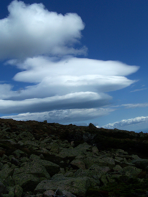
Lenticular Clouds
Looking down into the valley from the northwest Basin Trail
Trail info sign
Northwest Basin / North Peaks Trail Junction
View from Hamlin Peak
Dudley Ridge, Pamola Peak, Chimney Peak, and the Knife Edge
Baxter Peak
The Tableland
Baxter Peak
Knife Edge
Dudley Ridge
Howe Peaks
Looking down Hamlin Ridge to Basin Ponds
Knife Edge
Knife Edge
Basin Ponds
Hamlin Ridge
Dudley Ridge
A Waterfall in the Great Basin
Knife Edge and the Great Basin
Baxter Peak
Hamlin Ridge and Basin Ponds
Chimney Pond
Knife Edge and the Great Basin
Dudley Ridge
Moss and algae rock face in the Great Basin
Dudley Ridge
Dry Pond
The Great Basin
Knife Edge
Waterfall in the North Basin
Chimney Pond Trail and Roaring Brook
Flooded Chimney Pond Trail
Boardwalk along the Chimney Pond Trail
Hamlin Ridge from Basin Pond
Great shots! Hamlin Ridge is definitely one of my favorites on Katahdin.
ReplyDeleteThe picture you labeled as Millinocket Lake is actually Katahdin Lake.
Thanks, Glad you like the pics and I appreciate you helping me out on the mis-labeled lake!
DeleteChris:
ReplyDeleteUnbelievable pictures, not sure why I even bother snapping shots now - LOL
I especially liked the pictures of your group and others scrambling up and down the chimney and along the knife's edge. My pictures don't really capture how hard it is because there are no people around to get a perspective. I had about a 4-5 hour jump on you guys because I started at 0400 at Chimney Pond and went up Dudley. By the weather in the pictures, I was probably off Baxter when you guys were on Pamola, but we must have finished very close at Roaring River (I had to stop at Chimney pond for the rest of my gear). My GPS says I hit RR at 1915 and your TR suggets you guys were there near 7 pm also. There was a large grouop signing out at the RR ranger station when I completed, maybe that was you. I think I recognize the dog in your pictures. I gave the owner (from W. Virginia I think) and dog a lift into Millinocket on Friday. He had just finished the last leg of his AT section hiking and needed to go into town to call someone for a lift back at his car at the start of the 100 mile wilderness. Dog's arent allowed BSP but the guy said they turn a blind eye to AT finishers.
Nice! I was wondering what the story was behind the doggy. I figured the A.T. Dogs get a free pass to head up to Baxter Peak!
DeleteVery interesting,good job and thanks for sharing such a good blog.your article is so convincing that I never stop myself to say something about it.You’re doing a great job.Keep it up.
ReplyDeleteLobuche Peak Climbing